You’ll find Kentucky’s best spring ghost towns in the Big South Fork region, where Blue Heron’s metal silhouettes and Barthell’s restored coal camp offer immersive mining history from March through May. Paradise’s cemetery stands amid reclaimed lands once choked by power plant emissions, while Creelsboro’s natural arch overlooks a drowned river port. Bells Mines‘ regenerated forests harbor rare species in 7,574 acres of wilderness. April’s 55-65°F temperatures provide ideal conditions for photography, hiking, and exploring these atmospheric sites where Appalachian heritage meets scenic revival.
Key Takeaways
- Blue Heron offers outdoor metal shell structures, audio programs, and a 6.5-mile scenic loop accessible by car or railway.
- Barthell features fifteen restored company houses for overnight stays, guided mine tours, and accessible scenic railway access in spring.
- Creelsboro showcases the seventh-largest U.S. natural arch near a submerged river port town accessible off Highway 379.
- March through May provides ideal 55-75°F temperatures, optimal lighting, and full park services for ghost town exploration.
- Paradise Cemetery remains amid former coal plant site, while Golden Pond displays moonshine history at Land Between the Lakes.
Blue Heron: A Recreated Coal Mining Camp Along Big South Fork River
Deep in the Appalachian wilderness along the Big South Fork River, the ghost town of Blue Heron stands as a haunting tribute to Kentucky’s coal mining past.
This former coal community, also known as Mine 18, thrived from 1937 until its 1962 closure. Today, you’ll find open metal shells recreating the original structures—a coal tipple, railroad depot, school, and miners’ homes—positioned exactly where they once stood.
No original buildings survived, but photographic exhibits and audio programs bring the isolated mining town back to life. You can explore America’s largest interpretive collection of historic coal mining, experiencing what feels like historical reenactments frozen in time. Former residents’ voices share personal stories through the audio programs, offering intimate glimpses into daily life at the mining camp.
Access this Cumberland Plateau site by car or aboard the scenic railway from Stearns, discovering freedom in Kentucky’s untamed wilderness. Spring visitors can venture across the old coal train bridge to explore the 6.5-mile Blue Heron Loop, which offers scenic river paths and bluff overlooks showcasing the region’s natural beauty.
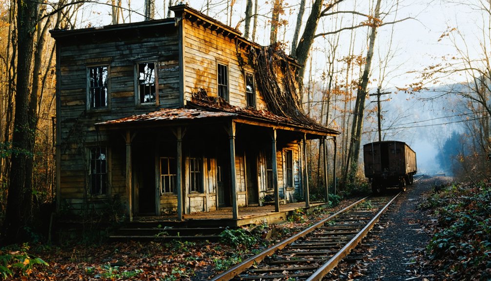
Barthell: Preserved Company Houses in the Appalachian Foothills
Nestled in the Appalachian foothills of McCreary County, Barthell preserves an authentic slice of Kentucky’s coal mining heritage through fifteen meticulously restored company houses available for overnight stays. You’ll discover architectural restoration at its finest—the Koger family invested over $500,000 transforming this 1902 mining camp into an open-air museum after purchasing it in 1984.
Wander freely through original structures showcasing early 20th-century coal camp life:
- Company store where miners once purchased provisions
- Historic doctor’s office and schoolhouse
- Concrete toilets built by CCC workers (1933-1936)
- Bath house from the 1930s expansion
- Post office serving 350 residents at peak operations
The camp’s origins trace back to L.E. Bryant’s supervision of Mine One and Two, which began operations in 1902 under the newly formed Stearns Coal Company. For the most adventurous visitors, guided tours offer the chance to descend 300 feet into an authentic coal mine. This historical preservation project reopened in 1999, offering you gateway access to Big South Fork National River and Recreation Area via the scenic railway each spring.
Paradise: The Town That Disappeared for Coal Power
Unlike most ghost towns that faded gradually, Paradise vanished by government decree—purchased and evacuated by the Tennessee Valley Authority after their massive coal-fired power plant transformed the town into an uninhabitable ash-covered wasteland.
Beginning in 1959, the Paradise Fossil Plant’s toxic emissions blanketed homes in sulfur dioxide and fly ash, making breathing difficult and dirtying everything it touched. By 1967, residents faced forced evacuation with minimal compensation—accept meager buyouts or lose property through condemnation.
The town’s origins trace back to a settlement called Stoms Landing, founded by Leonard Stom before being renamed Paradise after its reputation as a place that could cure sickness. Today, you’ll find only Paradise Cemetery accessible via rough roads through the industrial landscape. The economic impact once earned Muhlenberg County the nickname “Saudi Arabia of coal,” peaking at 26 million tons in 1972. The plant initially boasted the largest capacity worldwide when it opened in the 1960s, generating electricity for 950,000 homes.
Extensive environmental recovery efforts have since reclaimed much damage, though cooling towers still dominate the horizon.
Bells Mines: Hidden Forest Remnants in Big Rivers WMA
While Paradise met its end through industrial devastation, Bells Mines vanished through corporate maneuvering that left a landscape to heal itself. When Alcoa purchased 12,000 acres in the 1950s, families sold their homes at deep discounts—only to watch executives use the land as hunting retreats instead of building the promised smelter.
Today, forest regeneration has transformed abandoned homesteads into Big Rivers Wildlife Management Area‘s 7,574 acres of mature oak-dominated bottomland. The region encompasses six major rivers—the Mississippi, Ohio, Tennessee, Green, Tradewater, and Cumberland—creating a vast corridor of ecological significance. A recent 840-acre land acquisition expanded this protected area, now incorporating the Jenkins-Rich Tract into Crittenden County’s conservation landscape. You’ll discover wildlife habitats supporting:
- 16 rare plant species
- 25 rare animal species
- Endangered Indiana and gray bats
- Federally threatened northern copperbelly water snakes
- Critical spawning grounds for endangered alligator gar
Access this reclaimed wilderness from Sturgis via KY 365, where you’re free to hunt, fish, hike, or simply witness nature’s resilience.
Creelsboro: Pre-Dam Community Near a Natural Arch
You’ll find Creelsboro’s story written in water and stone, where the Cumberland River once flowed freely past what’s now the seventh largest natural arch in the United States.
The construction of Wolf Creek Dam in the 1940s transformed this bustling river port into a submerged ghost town, flooding the valley that had sustained eight generations of settlers since the 1840s.
Today, when you visit Rockhouse Natural Bridge, you’re standing at the edge of a drowned community that was nearly sacrificed entirely—the arch itself barely escaped becoming the dam’s foundation.
Before the dam, Creelsboro thrived as a steamboat era hub, serving as a bustling center of commerce and community life along the Cumberland River in Russell County. Incorporated in 1836, the town sat on the north bank where vessels like the Reuben Dunbar and Rowena brought goods and travelers to the region.
Cumberland Dam Impact History
The dam’s creation of Lake Cumberland brought profound changes:
- Destroyed the river valley that sustained generations of families
- Submerged historic architecture and archaeological sites
- Displaced residents from their ancestral lands
- Ended steamboat trade and traditional river commerce
- Created a 270 MW power station serving regional needs
Despite these losses, community resilience endures through oral histories and the PBS documentary “Creelsboro and the Cumberland: A Living History,” ensuring this river town’s legacy survives.
Rock House and Arch
Before Lake Cumberland reshaped the landscape, Creelsboro thrived as a bustling river port where nature had carved its own cathedral. You’ll discover the Rock House—a 140-foot-wide natural arch that’s stood for 300,000 years, the largest stone arch east of the Rockies.
Its historic significance runs deep: Native Americans used this spot for summer fishing camps and burial grounds atop the ridge. By 1809, settlers gathered here for camp meetings that drew 1,000 people beneath its protective canopy. Native traditions and frontier religion merged under this limestone ceiling.
Today, you can explore this unmarked wonder near Russell Springs, where scrambling boulders and river access await those who venture off Highway 379’s beaten path into Creelsboro’s untamed landscape.
Golden Pond: From Moonshine Haven to Managed Parkland
Nestled between the Tennessee and Cumberland Rivers, Golden Pond earned its notorious reputation as the “Moonshine Capital of the World” during Prohibition. During this time, up to 15 stills operated daily in the secluded hollows of western Kentucky.
Master stillmaker Casey Jones crafted distinctive equipment that produced premium spirits. These spirits were shipped to Al Capone’s Chicago operations, with buyers flying into nearby Fenton airstrip for deliveries.
Today’s Golden Pond offers different treasures:
* Historical preservation showcases a 100-year-old destroyed still.
- Wildlife observation opportunities are available throughout Land Between the Lakes.
- Spring wildflowers blanket former moonshine hideouts.
- Hiking trails wind through once-dangerous production sites.
- Educational displays chronicle the town’s rebellious past.
- March: Stabilized roads, lower snake activity, clear structural views
- April: Optimal photography light, moderate rainfall, accessible water features
- May: Maximum daylight hours, full park services, enhanced wildlife sightings
- Early spring: Reduced humidity, passable terrain
- Late spring: Blooming landscapes, established maintenance schedules
- Moisture-wicking base layer handles sub-40°F dawns
- Fleece mid-layer traps warmth during climbs
- Windproof shell counters gusts at exposed ruins
- Packable accessories (hat, gloves) combat early spring chill
- Ventilated options for 70°F+ afternoons
- Frame subjects between trees or doorways for controlled directional light
- Shoot backlit scenes by exposing for bright backgrounds and lifting shadow detail
- Use reflectors to bounce ambient light into darkened building interiors
- Avoid dappled foliage light that creates distracting color casts
- Select overcast days for even tones across textured surfaces
- Mammoth Cave’s underground passages near Cave City
- Cumberland Falls’ 44-foot cascade along Eagle Falls Trail
- Green River’s canoeing and fishing access
- Barren River Lake’s springtime water recreation
- Zip-lining through forest canopies above “knobs”
- https://kids.kiddle.co/List_of_ghost_towns_in_Kentucky
- https://en.wikipedia.org/wiki/List_of_ghost_towns_in_Kentucky
- https://wbkr.com/visit-these-20-creepy-kentucky-ghost-towns-for-a-halloween-road-trip/
- https://www.onlyinyourstate.com/experiences/kentucky/12-ghost-towns-in-ky
- http://freepages.rootsweb.com/~gtusa/history/usa/ky.htm
- https://www.youtube.com/watch?v=D9gOmfCuKLs
- https://everafterinthewoods.com/abandoned-ghost-towns-in-kentucky-that-still-hold-echoes-of-the-past/
- https://www.freakyfoottours.com/us/kentucky/
- https://www.geotab.com/ghost-towns/
- https://backyardknoxville.com/blue-heron-kentucky-mining-camp/
The TVA’s 1964 land acquisition transformed this bootlegger’s paradise into managed parkland, evicting final residents by 1970.
Best Times and Weather Conditions for Spring Ghost Town Exploration

Spring’s mild window transforms Kentucky’s ghost towns into accessible destinations, but you’ll need to time your visits around the state’s 4-5 inches of monthly rainfall and shifting temperatures.
These temperatures swing from March’s 50°F highs to May’s 75°F warmth. April offers the sweet spot—comfortable 55-65°F days perfect for exploring crumbling structures.
This is ideally done without the summer’s oppressive heat or winter’s ice-blocked access roads.
You’ll want layers in your pack and flexible plans that account for muddy trails after those frequent showers that bring the valleys to vibrant life.
Optimal Monthly Visiting Windows
When planning your Kentucky ghost town adventures, March through May delivers the sweet spot between winter’s harsh conditions and summer’s oppressive heat. Each month offers distinct advantages for your exploration freedom.
March brings awakening spring flora and manageable trails before vegetation overgrows forgotten pathways.
April strikes the perfect balance with extended daylight and comfortable temperatures for all-day expeditions.
May offers peak conditions with warm weather and minimal crowd interference at popular sites.
Your monthly advantages include:
Choose your timing based on desired solitude versus comfort levels.
Managing Rain and Mud
Kentucky’s spring rainfall transforms ghost town exploration into a calculated dance between opportunity and obstacle.
You’ll find late April through early May offers the sweet spot—warming temperatures coincide with wildflower blooms carpeting abandoned settlements while bird migration fills the silence above crumbling structures.
Wait 24-48 hours after storms before venturing out, allowing drainage to work its magic on saturated trails.
Equip yourself with waterproof boots featuring aggressive tread and gaiters to combat mud splatter at sites like Barthell and Blue Heron.
Morning expeditions beat afternoon thunderstorms while you’re steering through overgrown vegetation hiding foundation hazards.
Former mining camps present particular challenges—poor drainage near extraction sites creates persistent mud fields.
Pack trekking poles for stability on slippery slopes, and protect your camera gear from Kentucky’s notorious spring humidity.
Temperature Fluctuations and Layering
Between sunrise and sunset, Kentucky’s ghost towns become thermal roller coasters—March mornings greet you with frost-kissed ruins hovering near 35°F before afternoon sun pushes temperatures into the mid-60s, creating 25-degree swings that’ll leave you sweating through a fleece or shivering in a t-shirt.
Eastern ghost towns amplify these fluctuations through terrain elevation, while western sites stay milder.
Master these temperature shifts with adaptable layers:
Mid-April through early May delivers ideal 60-75°F stability—perfect when seasonal festivals and spring sports events bookend your ghost town adventures, letting you explore unencumbered by extreme swings.
What to Bring When Visiting Kentucky’s Abandoned Sites

Before you venture into Kentucky’s forgotten mining camps and abandoned settlements, proper preparation can mean the difference between a memorable exploration and a dangerous situation. Your gear essentials should include sturdy boots for traversing unpaved roads and rugged terrain, along with a powerful flashlight for dark mine entrances.
Pack a high-visibility vest, first-aid kit, and emergency whistle as critical safety precautions.
Don’t overlook protective clothing—long sleeves, gloves for handling rusted machinery, and waterproof layers for spring’s unpredictable weather. Orientation tools like GPS devices, offline maps, and a compass prove invaluable in areas without cell signal.
Bring water, snacks, and a multi-tool for extended explorations. For coal mining sites like Barthell, dust masks and hard hats protect against lingering hazards in these atmospheric ruins.
Photography Tips for Capturing Historic Structures and Landscapes
Spring’s softer light transforms Kentucky’s weathered structures into photographer’s gold. Morning mist clings to crumbling foundations while gentle rays illuminate decades of decay.
You’ll want to shoot during golden hour when warm tones saturate peeling paint, rusted metal, and moss-covered stone. This creates rich contrasts that tell stories of abandonment.
Position yourself to capture side-lighting that accentuates every crack, texture, and weather pattern. This turns forgotten walls into compelling subjects that reveal the passage of time.
Natural Spring Lighting Techniques
When photographing Kentucky’s abandoned settlements during spring months, you’ll discover that natural light transforms weathered timber and crumbling stonework into subjects rich with texture and atmosphere. Position yourself to catch morning or late afternoon rays striking structures at 45-90 degree angles, creating dimensional shadows that reveal architectural details lost in flat midday light.
Spring’s soft illumination works beautifully when you:
While artificial lighting and modern enhancements add creative possibilities, Kentucky’s natural spring conditions provide authentic atmospheric qualities.
Weathered Texture Composition Strategies
Mastering light sets the foundation, but your composition choices determine whether weathered surfaces become compelling visual narratives or forgettable snapshots. Frame Kentucky’s abandoned structures by filling your viewfinder with crumbling brick textures, peeling paint, and rust-stained metal that tells decades of stories.
Position these weathered textures using strategic angles—shoot low to emphasize towering facades or close-up to capture intricate decay patterns. Create depth by contrasting rough stone walls against smooth spring skies or pairing coarse wooden planks with delicate wildflowers reclaiming forgotten spaces.
Let cracked mortar and fractured window frames guide your viewer’s eye through the composition. These composition strategies transform ghostly remnants into powerful documentation of Kentucky’s past, revealing character in every weathered surface waiting for your lens.
Nearby Attractions and Dining Options to Complete Your Trip
Beyond the weathered structures and abandoned streets, Kentucky’s ghost town regions burst with complementary attractions that transform a historical expedition into a complete spring getaway.
During the warm months, the allure of abandoned places in Kentucky summer captivates those seeking adventure and stories of the past. Visitors can explore crumbling facades and overgrown paths while uncovering the rich history of the region. Each site tells a unique tale, inviting curiosity and exploration among those who wander through the remnants of yesteryear.
Kentucky’s ghost towns offer far more than forgotten ruins—they’re gateways to unforgettable spring adventures filled with history and natural beauty.
You’ll discover local folklore woven through preserved coal towns like Blue Heron, where audio recordings bring residents’ voices back to life, and Barthell’s fifteen restored miners’ homes offer authentic overnight stays.
Natural wonders await your exploration:
Preservation efforts extend beyond ghost towns to Mill Springs’ 1817 gristmill and Pleasant Hill’s Shaker settlement.
Cave exploration at Diamond Caverns and Louisville Mega Cavern rounds out your adventure, while local artisan shops and Jellystone Park campground provide essential amenities.
Frequently Asked Questions
Are Any Kentucky Ghost Towns Considered Private Property Requiring Permission to Visit?
Yes, you’ll find several Kentucky ghost towns on private property where permission’s required before exploring. Abandoned coal camps and defunct settlements often sit on owned land, so you must respect boundaries and seek landowner approval beforehand.
Which Ghost Towns Offer Guided Tours Versus Self-Guided Exploration Only?
Looking for haunted legends with expert guidance? You’ll find professional guided tours in Louisville, Lexington, and Newport’s historic districts. Meanwhile, Cave Hill Cemetery and Mammoth Cave offer self-guided exploration where preservation efforts maintain Kentucky’s supernatural heritage independently.
Can Visitors Enter the Buildings at These Ghost Towns Safely?
You can’t safely enter most abandoned buildings due to serious safety concerns—crumbling structures and decay create hazards. However, restored sites like Barthell Coal Camp offer secure overnight stays, while museums provide protected walkways through stabilized areas.
Are Kentucky Ghost Towns Accessible for Visitors With Limited Mobility?
Most Kentucky ghost towns aren’t accessible due to rugged terrain, but you’ll find mobility-friendly paths at alternatives like Bernheim Arboretum and Bridges to the Past. These accessible trails offer historical experiences without challenging navigation obstacles.
Do Cell Phones Have Reliable Service at Remote Ghost Town Locations?
You’ll find cell phone reliability vanishes like morning mist in Kentucky’s remote ghost towns. Emergency communication requires satellite devices at locations like Barthell and Blue Heron, where dense forests and deep valleys swallow signals completely.