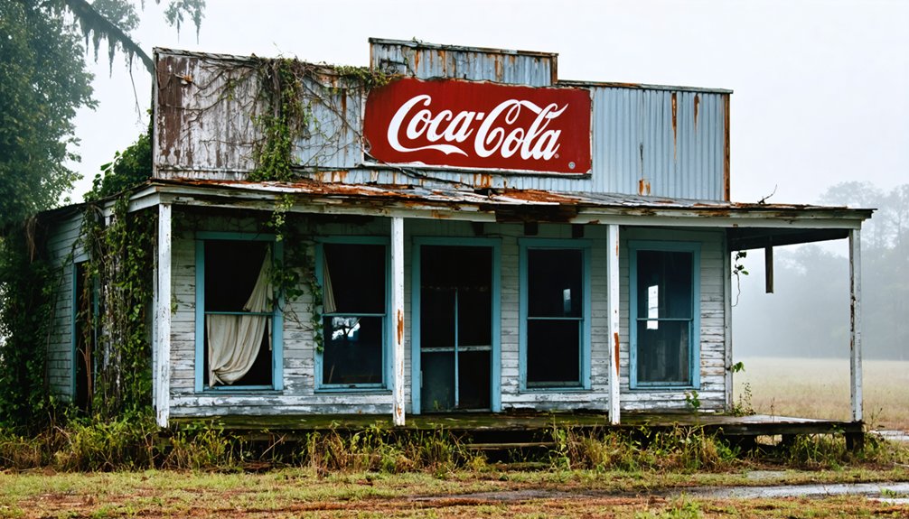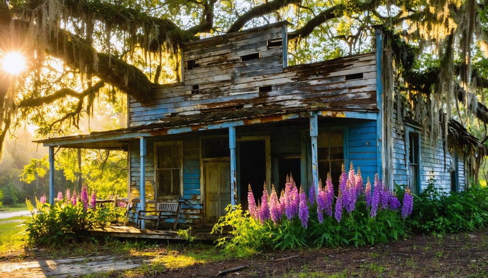
You’ll find Louisiana’s most hauntingly beautiful ghost towns awaken in spring, when wildflowers bloom across Cheniere Caminada’s hurricane-ravaged cemetery and floodwaters recede around Bayou Chene’s sunken ruins. Navigate moss-draped trails through Ruddock’s overgrown railroad beds, boat past Sherburne’s decaying sawmill foundations in the Atchafalaya Basin, or witness Isle De Jean Charles disappearing into the Gulf at an acre per hour. Each site whispers stories of storms, timber booms, and resilient communities that vanished beneath Louisiana’s shifting waters and soils, revealing secrets waiting to be discovered.
Key Takeaways
- Cheniere Caminada features hurricane-destroyed structures, 779 victims’ graves, and spring wildflowers blooming across salt-scarred coastal soils.
- Ruddock/Frenier offers overgrown railroad beds, sawmill ruins, and a mass grave crucifix amid alligator-filled channels near Highway 51.
- Bayou Chene lies submerged under 12 feet of silt, accessible only by boat for bass fishing and airboat tours.
- Sherburne’s abandoned sawmill ruins sit within 43,637-acre wildlife trails featuring cypress groves and spring wildlife viewing opportunities.
- Essential gear includes sturdy boots, insect repellent, offline maps, and permits for cemetery visits in flood-prone areas.
Cheniere Caminada: Wildflowers Among Hurricane Ruins
When spring rains coax wildflowers from the salt-scarred soil along Louisiana Highway 1, they bloom among the crumbling brick tombs of Cheniere Caminada—a fishing village that death swept into the Gulf on October 2, 1893.
You’ll find what remains: a small cemetery where a sinking oak tree guards graves of 779 souls claimed by the Category 4 hurricane‘s 18-foot surge. The abandoned structures of this once-thriving Creole resort vanished overnight, leaving only this haunted ground where locals whisper of feux follets dancing near disturbed graves. The storm surge flooded the island so completely that it split open graves in the local cemetery, scattering the dead across the marshy ground.
Walk carefully through the hurricane aftermath—wildflowers now reclaim what seawater destroyed, blooming defiantly on coastal ground that continues sinking. Among the few structures to survive stands the Curole house, dismantled and moved 40 miles inland to Cut Off, where it remained intact for over a century before restoration in 2022. The church bell, cast from pirate gold, vanished. Only spring’s persistent beauty refuses to forget.
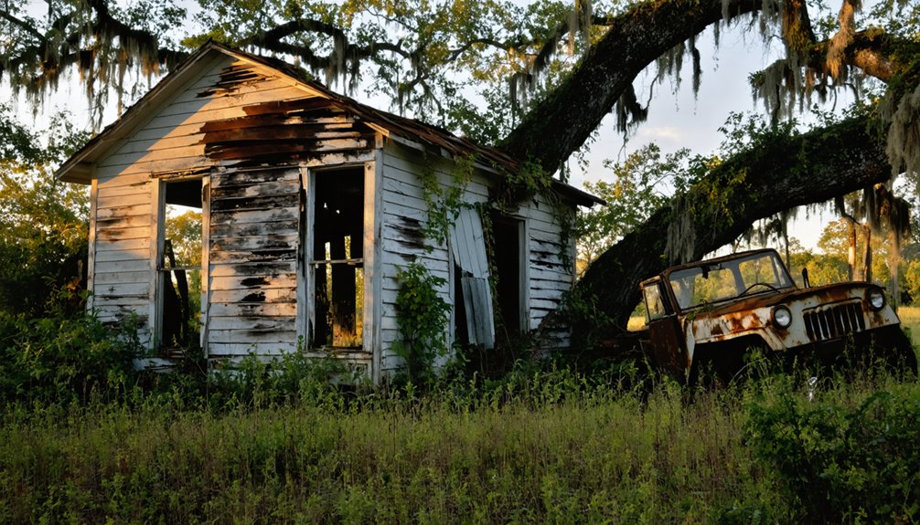
Ruddock / Frenier: Overgrown Trails of a Lost Community
Where Louisiana Highway 51 crosses forgotten railways near Lake Pontchartrain’s western shore, spring vines strangle the last remnants of Ruddock and Frenier—twin settlements the 1915 hurricane erased with such violence that survivors spoke of drowning screams echoing through snapped cypress.
You’ll navigate overgrown railroad beds through waterlogged pathways, where sawmill foundations crumble beneath resurrection ferns. The abandoned logging town left behind floating broken logs that still drift through pea-green waters, remnants of an industry that once thrived here. Pierre Le Moyne d’Iberville first explored these lands in 1699, centuries before the cypress mills would rise and fall. Cypress swamp exploration reveals the mass grave marked by a weathered crucifix, then Julia Brown’s solitary resting place 100 yards distant—the voodoo priestess whose song promised she’d “take the whole town with me.”
Airboat guides weave legend storytelling through channels where 300 souls perished, their settlement now ruled by alligators and Rougarou folklore. Spring’s dense undergrowth reclaims everything human ambition built, leaving only whispers.
Isle De Jean Charles: Where Land Meets the Disappearing Gulf
Along Louisiana’s crumbling coast where the Gulf swallows an acre every hour, Isle de Jean Charles rises as a defiant sliver—less than a quarter-mile wide now, though it once sprawled across 22,000 acres of marshland that sheltered generations who’d fled persecution.
You’ll find the Isle de Jean Charles Band of Biloxi-Chitimacha-Choctaw still clinging to what remains, though 98% has vanished since 1955. Their cultural heritage pulses through abandoned houses where trappers and oystermen once thrived, through dome-shaped mud dwellings rotted into memory. The island’s origin traces to a forbidden marriage between Frenchman Jean Marie Naquin and Indian woman Pauline Verdin, whose descendants built a community that would endure discrimination and isolation for generations.
Land preservation came too late—they’re America’s first climate refugees, resettling forty miles inland. The Houma Canal, dredged in 1962 to transport oil and resources to the Gulf, accelerated the subsidence that doomed the island. Visit while you can still drive the single road connecting this dying refuge to solid ground, witnessing what happens when the government chooses levees over people.
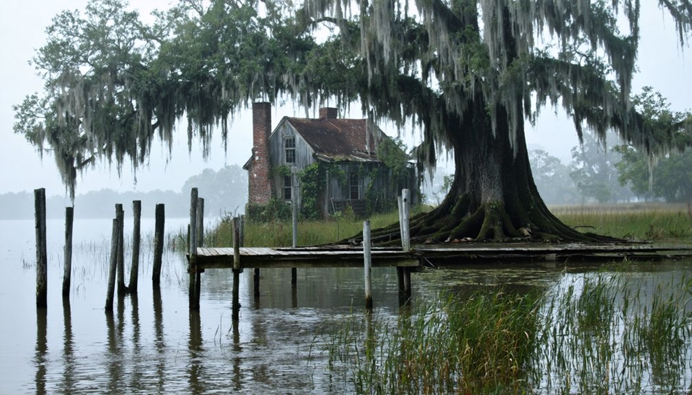
Bayou Chene: Fishing and Birdwatching in Flooded History
Twelve feet of Mississippi silt buries what was once Bayou Chene’s thriving main street, swallowing the post office, church steeples, and merchandise store that served 500 souls before the Great Flood of 1927 drowned this logging community for good.
You’ll reach this ghost town only by boat, pushing through cottonwoods and cypress where families once raised cattle on dry land. Historical artifacts emerge from brambles—a cracked Virgin Mary statue testifies to faith that couldn’t withstand the flood impact. The Chitimacha Tribe inhabited these grounds long before loggers arrived, leaving their own imprint on this layered landscape.
Spring transforms this haunted ground into prime territory: crawfish cluster near muddy banks while waterbirds nest in flooded tupelo groves. The Bayou Chene Floodgate, completed in 2022, now protects surrounding communities from the basin’s fury, closing within hours when waters threaten to rise.
Cast your line for bass in channels where schoolchildren once walked, or book an airboat tour to explore where descendants still honor their submerged heritage.
La Balize: Uncovering Louisiana’s First French Settlement
Before New Orleans claimed its crescent, before Bourbon Street earned its reputation, a weathered wooden pyramid rose 62 feet above the Mississippi Delta’s treacherous mouth—this was La Balize, Louisiana’s first French settlement, where pilots squinted through fog to guide ships past sandbars that shifted with every spring tide.
What Remains of La Balize’s Legacy:
- Historical preservation exists only in records—the site vanished beneath Gulf waters after the 1865 hurricane swept away final traces
- Colonial architecture featured Adrien de Pauger’s 1721 crescent-shaped fort, now lost to Louisiana’s hungry tides
- The active Balize Delta still bears the settlement’s name, marking where fishermen once lit rocket signals from watchtowers
- Pilottown’s ruins stand five miles upriver, abandoned after Katrina claimed what hurricanes couldn’t finish
Robert de La Salle claimed this strategic position for France in 1682, recognizing its command over the river’s major forks and the vital passage to New Orleans. The settlement’s inhabitants lived in houses positioned on piles amidst water and high reeds, navigating between dwellings on narrow plank footpaths.
You’ll find nothing but water where pioneers once defied nature’s fury.
Sherburne: Logging Legacy in the Atchafalaya Basin
You’ll find Sherburne’s remnants scattered through the Atchafalaya Basin, where cypress loggers once floated massive timber downriver as a lifeline during the 1870s. Today, trails wind through the Wildlife Management Area where sawmill foundations and rusted equipment peek through Spanish moss and palmetto fronds.
Spring transforms this ghost town into a birder’s paradise, with nesting herons and egrets reclaiming what the Great Flood of 1927 swept away from Louisiana’s swamp communities.
Abandoned Sawmill Town History
Deep within the Atchafalaya Basin’s tangled waterways, Sherburne once thrived as a bustling sawmill town where the screech of blade against cypress punctuated humid mornings and wood smoke hung perpetually in the air.
You’ll discover a logging history that mirrors Louisiana’s boom-and-bust timber era, when lumber companies carved self-contained communities from swampland. Workers inhabited company housing, sent children to company schools, and shopped at company stores—a complete microcosm that vanished when timber reserves depleted.
Today’s ghost town preservation efforts reveal:
- Decaying mill ponds where logs once floated awaiting processing
- Abandoned cemeteries marking families who chased the timber frontier
- Foundation remnants of homes and commercial buildings
- Integration with Atchafalaya Wildlife Management Area for exploration
You’re witnessing freedom’s double-edged sword—prosperity’s arrival and inevitable departure.
Wildlife Management Area Trails
Where Sherburne’s sawmill foundations crumble into Atchafalaya mud, the 43,637-acre Wildlife Management Area has reclaimed industrial scars with a labyrinth of trails threading through bottomland hardwoods. You’ll navigate the Highline Trail and Big Alabama PC Trail on foot or ATV, passing skeletal remnants of historical architecture—rusted machinery dissolving beneath cottonwood-sycamore canopies and oak-gum thickets strangled by rattan vines.
Local legends whisper through Skull Rd Trail and Happytown Trail names, echoing the South Farm Complex‘s forgotten timber camps where loggers once carved fortunes from swamp giants.
Access the northern reaches via Highway 975, or launch from Big Alabama Bayou to explore by water. Spring floods breathe life into these pathways, transforming logged-out wilderness into something wild again—no permits, no restrictions, just vanished industry returning to primal silence.
Spring Nature Viewing Opportunities
As spring meltwater floods through Sherburne Wildlife Management Area, the Atchafalaya Basin transforms into a cathedral of resurrection—120-year-old cypress trees rising from water stained the color of tea, their knobby knees breaking the surface like monuments to survival.
You’re witnessing cypress conservation in action. These second-growth forests replaced the old-growth giants logged between 1880-1930. Today’s wetland restoration efforts protect what remains after 83,000 acres fell to mulch production by 2006.
What makes spring viewing unforgettable:
- Dawn light filtering through Spanish moss-draped canopies
- Cypress knees emerging as floodwaters recede
- Bottomland hardwoods bursting with new growth
- Evidence of successful logging resistance since 2012
You’re exploring landscapes that foreign companies recognized as “assets to humanity”—forests your government once permitted destroying.
Planning Your Spring Ghost Town Adventure in Louisiana
Your journey through Louisiana’s abandoned settlements demands thoughtful preparation—sturdy hiking boots for overgrown trails at Ruddock, insect repellent for the mosquito-thick air around Bayou Chene, and rain gear tucked in your pack as spring showers roll across the wetlands.
Before you venture down gravel roads toward East Krotz Springs or navigate the forested paths of Sherburne Wildlife Management Area, verify flooding conditions and secure any necessary permits, since recent Morganza Spillway openings can transform accessible sites into submerged landscapes overnight.
Map your route along I-55 and US-65, clustering visits to Pointe Coupee Parish‘s ghost towns—Torras, Waterloo, and False River—to maximize daylight hours while your cell signal still holds strong.
Essential Gear and Supplies
Since Louisiana’s ghost towns occupy landscapes where humidity clings to your skin and mosquitoes hatch by the thousands each spring, proper gear transforms potential misery into genuine adventure.
You’ll need equipment that handles both environmental extremes and documentary opportunities.
Essential items for ghost town exploration:
- Clothing foundation – Long sleeves, waterproof boots, and quick-dry synthetics combat ticks, mud, and sudden thunderstorms while you navigate eroded sites like Burrwood.
- Defense arsenal – Pack 50+ SPF sunscreen, 30% DEET repellent, and polarized sunglasses against relentless UV and mosquito swarms.
- Navigation backup – GPS phones with offline maps, handheld compasses, and two-way radios keep you oriented where cell towers vanish.
- Photography tips – Bring weatherproof camping gear, extra batteries, and microfiber cloths to capture dawn light filtering through skeletal structures without equipment failure.
Safety Precautions and Permits
Spring exploration demands practical preparation: pack recovery gear for washed-out dirt roads, bug spray for swampy approaches, and defensive training for isolated encounters.
Near industrial ghost towns, cancer risks spike 800 times above average—seek shelter when emissions intensify during rain.
Secure permits through Louisiana’s archaeology division before disturbing cemetery grounds, and report hazards to 1-800-256-5452.
Travel in groups; freedom thrives within boundaries.
Best Routes and Transportation
When planning your Louisiana ghost town expedition, the state’s network of highways and backroads becomes your gateway to forgotten settlements scattered across parishes like waypoints on a treasure map.
Strategic Routes for Maximum Exploration:
- Pointe Coupee Parish Circuit – Circumnavigate East Krotz Springs, Torras, and Sherburne within concentrated distances, accessing sites via routes near Livonia and riverside corridors where historical preservation efforts reveal Atchafalaya’s vanished communities.
- Vernon Parish Backroad Trail – Connect Alco (LA 465), Hawthorn, Kurthwood, and Pitkin through unified highway systems threading through piney woods and forgotten railroad junctions.
- Water-Accessible Sites – Spring’s moderate water levels optimize accessibility to riverside ghost towns; local guides prove invaluable steering seasonal flooding patterns.
- DeSoto Parish Loop – Highway 171 links Benson, Hollingworth, Frierson, and Kingston along historic KCS railroad corridors.
Frequently Asked Questions
Are Guided Tours Available for Visiting Louisiana’s Ghost Towns in Spring?
You’ll find guided tours exploring Louisiana’s haunted sites rather than abandoned ghost towns. These spring adventures immerse you in local legends and historic preservation efforts, where French Quarter mysteries and plantation spirits awaken your senses through enthralling storytelling.
However, for those intrigued by the allure of exploration, abandoned towns in Louisiana reveal hidden stories of resilience and decay. Each deserted street and crumbling building whispers echoes of the past, inviting adventurers to uncover what once thrived in these forgotten spaces. Exploring these remnants offers a unique perspective on the state’s rich history and diverse culture.
What Safety Precautions Should Visitors Take When Exploring Abandoned Settlements?
Tread carefully through time’s forgotten corridors—you’ll need sturdy boots for unstable floors, awareness for wildlife encounters lurking in shadows, and respect for historical preservation. Stay alert, travel together, and let your instincts guide your adventure through Louisiana’s abandoned past.
Do I Need Special Permits to Access Ghost Town Sites?
You’ll need to check local regulations before exploring, as some ghost towns sit on private property or protected land. Historical preservation laws may restrict access, so research ownership and obtain permission to roam freely and legally.
Can I Camp Overnight Near Any of These Ghost Town Locations?
You’ll find limited camping options near Louisiana’s ghost towns due to historical preservation restrictions. However, you can explore nearby state parks where local legends come alive around campfires, offering you the freedom to immerse yourself in haunting tales under starlit skies.
What Photography Equipment Works Best in Louisiana’s Humid Spring Weather?
You’ll want waterproof gear with weather-sealed bodies and lenses to handle Louisiana’s spring humidity. While film cameras evoke nostalgic charm, they’re vulnerable to moisture. Modern sealed equipment protects your creative freedom during spontaneous downpours.
References
- https://www.ezhomesearch.com/blog/ghost-towns-in-louisiana/
- https://en.wikipedia.org/wiki/List_of_ghost_towns_in_Louisiana
- https://classicrock1051.com/17-ghost-towns-louisiana/
- https://www.ghosttowns.com/states/la/la.html
- https://www.youtube.com/watch?v=e9N4ENaiTRI
- https://jonesswanson.com/mails/louisianas-disappearing-towns-tool-kit/
- https://heartoflouisiana.com/cheniere-caminada-hurricane/
- https://64parishes.org/entry/cheniere-caminada-hurricane
- https://files.eric.ed.gov/fulltext/EJ1462702.pdf
- https://grandisleevents.org/wp-content/uploads/2022/04/Early-History-of-Grand-Islenand-Cheniere-Caminada.pdf