Spring transforms Oklahoma’s ghost towns into wildflower-dotted time capsules you’ll want to explore from April through May. You can walk through Picher’s toxic chat piles and abandoned streets, stand where the Doolin-Dalton Gang battled federal marshals in Ingalls, and photograph crumbling Route 66 landmarks like Texola’s Magnolia Service Station. Pack sturdy boots, water, and offline maps for exploring rural counties where you’ll discover everything from Native American trading posts to lawless frontier outposts that reveal the state’s complex environmental, outlaw, and cultural heritage.
Key Takeaways
- Boggy Depot State Park offers trails, fishing lakes, and preserved Chickasaw settlement ruins ideal for spring exploration.
- Texola features Route 66 relics including the Magnolia Service Station, best visited when wildflowers bloom in spring.
- Ingalls commemorates the 1893 gunfight with markers and foundations, perfect for history enthusiasts during mild spring weather.
- Picher displays stark environmental history with toxic chat piles, accessible for educational visits in temperate spring conditions.
- Liberty celebrates Black homesteader heritage through spring cultural festivals, churches, and community-led preservation efforts.
Picher: From Mining Powerhouse to Superfund Site
When Harry Crawfish’s 1913 claim revealed rich veins of lead and zinc beneath northeastern Oklahoma’s red dirt, nobody imagined the discovery would birth one of America’s most cautionary tales.
You’ll find Picher’s mining history written across a landscape of towering chat piles—70 million tons of toxic tailings that once fueled half of World War I’s ammunition needs.
The town that housed 14,252 souls in 1926 now stands empty, its 14,000 abandoned shafts leaking contaminated water through collapsing streets.
Since the EPA’s 1983 Superfund designation, environmental recovery battles against decades of unchecked extraction.
The cleanup efforts, completed in 2008, cost over $160 million and included soil remediation, well sanitization, and chat re-integration.
You can’t miss the ghostly remnants of what prosperity costs when profit trumps preservation—a stark reminder that freedom includes accountability for the ground beneath our feet.
The distinct geographical location of Picher serves as one of Oklahoma’s most striking examples of how a once-thriving community can be transformed by industrial consequences.
Ingalls: Where the Dalton Gang Made History
When you step into Ingalls on a spring morning, you’re walking the same dirt streets where the Doolin-Dalton Gang’s hideout erupted in gunfire on September 1, 1893—a shootout that left three lawmen dead and eight horses sprawled in the dust.
The weathered remnants of Ransom’s Saloon and the hotel where “Arkansas Tom” Jones fired from a second-story window still mark the battlefield where outlaws made their desperate escape to the livery stable. The gang members had been playing poker inside the saloon when U.S. Marshals surrounded the town, ignoring earlier warnings to leave.
You’ll find interpretive markers near the actual combat sites, tracing the blood trail of a gunfight that claimed nine casualties and cemented Ingalls as the Wild Bunch’s most notorious sanctuary. Located 9 miles east of Stillwater, this once-thriving community of 150 residents has vanished from state highway maps, leaving only these haunting reminders of its violent past.
Historic 1893 Shootout Events
During the sweltering morning of September 1, 1893, twenty-seven U.S. Marshals crept into Ingalls, transforming this outlaw sanctuary into a war zone.
You’ll discover where Bill Doolin’s gang, already warned of the posse’s approach, defiantly sent messengers challenging deputies to enter. Arkansas Tom Jones fired from the O.K. Hotel’s second-story window, killing Deputy Thomas Hueston.
The outlaws bolted from Ransom Saloon toward the livery stable—bullets screaming through dusty streets. Three lawmen died; civilian Frank Briggs fell to a stray round. Though most gang members evaded immediate capture, U.S. Marshals tracked down and apprehended the remaining outlaws in the weeks that followed.
Today, ghost town legends whisper through abandoned foundations where this deadly confrontation unfolded. Native folklore still echoes in the wind across these blood-stained grounds, marking one of the Old West’s most ferocious gunfights and the fragmentation of Oklahoma Territory’s most notorious gang. Located just 8 miles east and 1 mile south of Stillwater on Highway 51, the Outlaw Battle Site commemorates the sacrifice of U.S. Marshals Dick Speed, Tom Houston, and Lafe Shadley who fell in the line of duty.
Rail Commerce Heritage Sites
Beyond the blood-soaked grounds of the 1893 shootout, you’ll find Ingalls served a far more calculated purpose—a strategic nerve center where rail commerce fed outlaw ambitions. Railway architecture from this era connected Oklahoma Territory to Kansas, creating corridors the Doolin gang exploited ruthlessly.
You’ll trace their 1891-1892 operations from the May Wharton heist to September’s Liletta station job, where compliant passengers surrendered without resistance. George Ransom’s saloon anchored this supply hub, transforming town infrastructure into outlaw headquarters.
Citizens stockpiled ammunition, sheltered horses, and tracked marshal movements—commerce disguised as hospitality. The Dalton brothers drew inspiration from their famous cousins, the James-Younger Gang, before carving their own violent path through these rail territories. When fourteen lawmen arrived that September day, eight to ten horses lay dead afterward.
The Battle of Ingalls erupted inside George Ransom’s saloon on September 1, 1893, when Deputy Marshal John Hixon led his men against Doolin and Bill Dalton. Town economic decline followed inevitably. The same rails that birthed prosperity delivered Ingalls’ demise.
Boggy Depot: Ancient Choctaw Trading Center
Nestled along the Boggy and Blue Rivers in what’s now Atoka County, Boggy Depot emerged as the largest Chickasaw settlement in Indian Territory after the forced removal of 1837.
You’ll discover a site where tribal history intersects with pioneer settlements—where Choctaw and Chickasaw peoples built a thriving hub along military roads connecting Fort Washita to Fort Smith.
Walking these grounds, you’ll trace the footsteps of gold rush travelers who stopped at the Butterfield Overland Stage station. The town flourished with blacksmith shops, mills, and trading posts serving the Texas Road‘s constant traffic.
Confederate forces later established their primary supply depot here during the Civil War.
The post office ceased operations in 1883 as the railroad’s bypass to Atoka drew away the town’s remaining commerce and residents.
Today’s Boggy Depot State Park preserves this legacy. You’ll find fishing lakes and trails where commerce once thundered past, now managed by the Choctaw Nation. The ghost town gained renewed recognition when musician Jerry Cantrell named his 1998 album after this Oklahoma settlement where his father grew up.
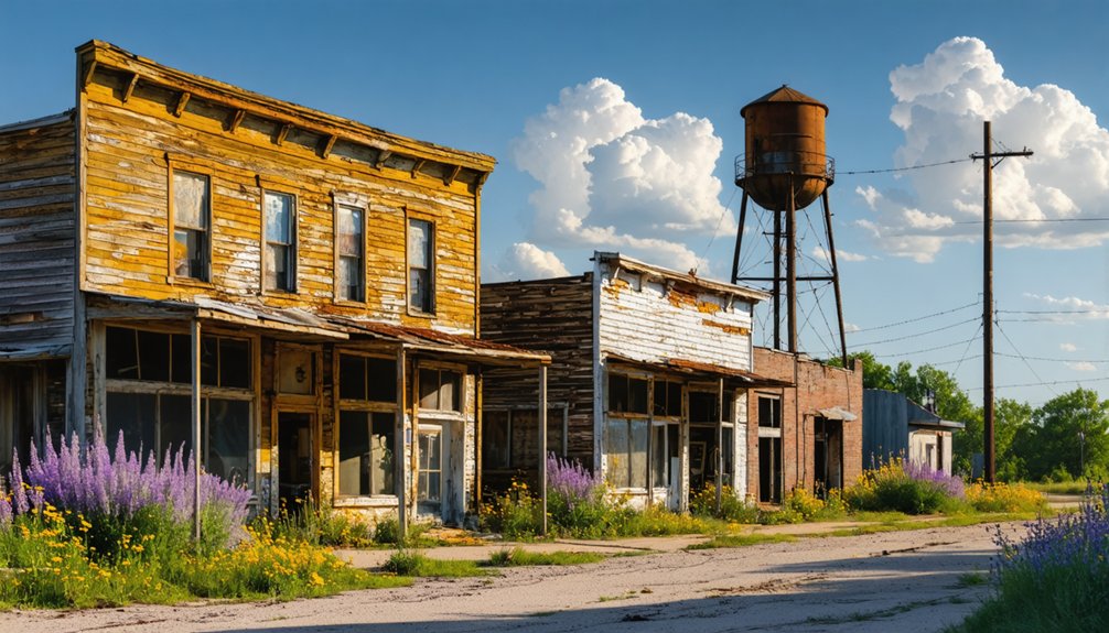
Texola: Route 66’s Fading Memory
When you stand on Texola’s cracked pavement where Route 66 once hummed with cross-country travelers, you’ll witness how quickly prosperity vanishes when highways shift course.
The Magnolia Service Station’s weathered walls and empty storefronts tell the story of a town that peaked at 581 residents in 1930, only to shrink to just 40 souls after Interstate 40 rerouted America’s journey elsewhere.
Spring wildflowers now push through abandoned sidewalks where motorists once lined up for gas, transforming this former “Main Street of America” stop into a haunting lesson about resource dependence.
Historic Route 66 Heritage
Along Oklahoma’s far western edge, where the pavement meets the Texas Panhandle, Texola stands as Route 66’s ghostly bookend—a town that once thrived on cotton and cross-country traffic but now exists as little more than peeling paint and broken windows.
You’ll find the 1920s Magnolia Service Station on the National Register, its weathered shell representing architectural preservation efforts along America’s Mother Road. The one-room jail predating 1910 draws Route 66 pilgrims seeking authentic roadside history.
Spring visitors discover Tumbleweed restaurant operating in the oldest surviving Route 66 structure, while No Place Like Texola bar maintains the town’s frontier spirit.
Texola hosted the Will Rogers Highway rededication ceremony, marking its significance in cultural festivals celebrating westward migration. Though I-40’s bypass left only thirty-five residents, the town preserves Route 66’s raw, unvarnished legacy.
Decline of Resource Towns
Texola’s story mirrors countless American towns that bet their futures on resources that wouldn’t last.
You’ll find urban decay etched into every corner—the Magnolia Service Station that pumped its last gallon in the 1980s, the one-room cinderblock jail standing empty since 1910, and abandoned buildings that once housed thriving cotton gins and hotels.
Walk through streets where 580 residents once lived and worked.
The Dust Bowl drove families west in the 1930s, oil reserves dried up, and when Interstate 40 bypassed the town in the early 1970s, Texola’s fate was sealed.
Today, 40 people remain among bleached signs and derelict structures— a raw emblem of what happens when highways move on and resources run out.
Kusa: Okmulgee County’s Coal-Smelting Giant
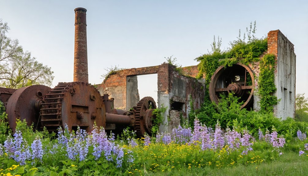
Rising from the coal-rich earth of Okmulgee County in 1916, Kusa exploded onto Oklahoma’s industrial landscape as a planned city that promised fortunes in lead smelting and mining. With 3,500 residents, banks, theaters, and its own newspaper, it became the county’s largest city—until railroads and highways chose neighboring Henryetta instead.
Within two decades, Kusa vanished. Today, your Kusa exploration reveals only foundations and “No Trespassing” signs off Highway 266 near Dewar. Spring’s mild weather makes the journey ideal, though you’ll need landowner permission.
Ghost town stories live on through the preserved Kusa Industrial microfilms at Henryetta’s library, documenting the boom-and-bust cycle that killed this industrial giant before it reached adulthood.
Liberty: Preserving All-Black Town Heritage
While Kusa’s story speaks to industrial ambition gone cold, Liberty’s narrative pulses with a different heartbeat—one of cultural resilience and intentional memory-keeping.
You’ll find this community maintaining its identity through grassroots determination rather than tourist infrastructure. The historical landmarks here aren’t polished attractions—they’re lived spaces where descendants gather at modest churches and cemeteries that anchor family histories.
Spring visits coincide with cultural celebrations when oral traditions pass between generations, sharing stories of homesteading courage and self-governance.
You won’t encounter guided tours or visitor centers; instead, you’ll need local permission and genuine respect. This isn’t abandonment—it’s active preservation through community presence.
Liberty reminds you that some histories survive best when protected by those who carry them forward, not commodified for outsiders.
Beer City: No Man’s Land’s Outlaw Haven

Stepping into Beer City’s history means entering a place where jurisdiction itself had failed. In 1888, this outlaw sanctuary emerged in No Man’s Land, where cattle rustlers, gunfighters, and fugitives found refuge beyond any law’s reach.
Where federal, state, and territorial boundaries collided, Beer City thrived in the legal void that law enforcement couldn’t penetrate.
Captain William Coe’s gang of 50 operated from nearby Robber’s Roost, stealing livestock across state lines with impunity.
You’ll discover urban legends surrounding Pussy Cat Nell’s Yellowsnake Hotel and the vigilante killing of “Marshal” Lewis Bush—shot with eight bullets and 23 pellets by multiple townspeople protecting each other’s identities.
Unfortunately, preservation efforts face challenges as little remains of this sudsy cowboy haven. The Organic Act of 1890 brought territorial law, ending Beer City’s wild existence.
Its population scattered overnight, leaving behind stories of authentic frontier chaos.
Planning Your Oklahoma Ghost Town Adventure
Before you set out across Oklahoma’s backroads, you’ll need to map a route that balances accessibility with authenticity. Spring flowerings transform desolate sites into wildflower meadows, making April through May ideal for exploration.
Essential preparations include:
- Route mapping – Download offline maps for Alfalfa and Pawnee counties where cell service disappears between abandoned settlements.
- Safety gear – Pack sturdy boots for uneven terrain at sites like Skedee, plus water and insect repellent for extended rural wandering.
- Accommodation strategy – Book rural accommodations near Route 66 or Talimena Scenic Drive to access multiple ghost towns efficiently.
You’ll encounter everything from collapsing structures to cemetery grounds requiring respectful distance.
Check property boundaries, monitor spring storm forecasts near Lake Spavinaw, and time visits during 12-14 hour daylight windows for maximum exploration freedom.
Frequently Asked Questions
What Safety Precautions Should I Take When Exploring Abandoned Ghost Town Structures?
Better safe than sorry—you’ll need protective equipment like sturdy boots and flashlights for hazard awareness. Watch for rotting floors, toxic contamination, and crumbling walls. Travel with others, respect boundaries, and trust your instincts when exploring these forsaken places.
Are There Guided Tours Available for Oklahoma’s Ghost Towns?
You’ll find guided ghost tours primarily in Oklahoma City, not rural ghost towns. These walking experiences weave local legends with historical preservation efforts, focusing on urban haunted sites rather than abandoned settlements you’d explore independently in the countryside.
While the excitement of urban ghost tours is undeniable, many adventure seekers yearn for a different experience, seeking hidden ghost towns in Oklahoma. These forgotten places tell stories of the past and invite exploration away from the noise of the city. Each abandoned structure and deserted street holds a unique narrative waiting to be uncovered for those willing to wander off the beaten path.
Can I Legally Take Artifacts or Souvenirs From Ghost Town Sites?
No, you can’t legally take artifacts—legal restrictions protect these sites fiercely. Artifact preservation laws impose hefty fines and jail time. Even small souvenirs trigger prosecution. Photograph memories instead; touching history means leaving it intact for future explorers.
Which Ghost Towns Have Restroom Facilities or Nearby Amenities for Visitors?
Locust Grove offers the best restroom availability through its two museums, while nearby amenities include kayak rentals and lakes. Ingalls provides parking and Home2 Suites nearby. Afton’s local motels support your exploration freedom along Route 66.
What Is the Best Time of Day to Photograph Ghost Towns?
Chase the golden glow—you’ll capture ghost towns beautifully during early morning photography sessions or sunset lighting hours. Arrive around 6-7 AM or 7-9 PM when soft rays illuminate weathered structures, creating dramatic shadows that tell Oklahoma’s forgotten stories perfectly.
References
- http://sites.rootsweb.com/~oktttp/ghost_towns/ghost_towns.htm
- https://kids.kiddle.co/List_of_ghost_towns_in_Oklahoma
- https://www.ghosttowns.com/states/ok/ok.html
- https://www.youtube.com/watch?v=5d-wHDTIbb0
- https://pocketsights.com/tours/tour/Shamrock-Oklahoma-Ghost-Towns-Creek-Lincoln-Payne-and-Pawnee-Counties-2749
- https://abandonedok.com/class/disappearing-town/
- https://www.okhistory.org/publications/enc/entry?entry=GH002
- https://en.wikipedia.org/wiki/Picher
- https://abandonedok.com/picher-ok/
- https://pubs.usgs.gov/pp/0588/report.pdf


