You’ll find Oregon’s ghost towns especially enchanting in spring when wildflowers frame weathered buildings and waterfalls surge with snowmelt. Head to Shaniko for authentic Wild West architecture, explore Friend’s isolated homesteads amid golden wheat fields, or visit the massive Sumpter Valley Dredge surrounded by blooming lupine. Don’t miss Champoeg State Park where Oregon’s government was born, or White River Falls‘ dramatic 90-foot cascade beside abandoned powerhouse ruins. Pack layered clothing and high-clearance vehicles for remote sites, as spring conditions bring both vibrant beauty and muddy back roads that’ll reward your adventurous spirit with uncrowded exploration opportunities.
Key Takeaways
- Shaniko features authentic Wild West architecture, including the 1900 hotel and water tower, with festivals hosted each August.
- Friend Ghost Town offers spring wildflowers like lupine and balsamroot alongside weathered homesteads in verdant high desert valleys.
- White River Falls State Park combines a 90-foot waterfall with abandoned powerhouse ruins, best viewed during high spring flows.
- Sumpter Valley Dredge preserves gold mining heritage with 72-bucket machinery and visible tailings across 93 accessible acres.
- Champoeg State Park blends ghost town history with the 1843 provisional vote site and the preserved 1852 Newell House museum.
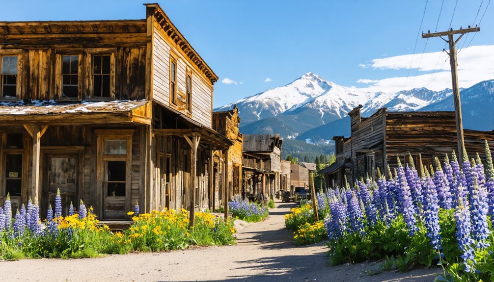
Shaniko Ghost Town: Wild West Character on Display
Nestled in the high desert plains 40 miles northeast of Madras, Shaniko rises from the sagebrush like a weathered monument to Oregon’s wool empire. You’ll find authentic Wild West architecture lining the dusty main street—the 1900 Shaniko Hotel’s 18-inch brick walls still stand strong, recently reopened after meticulous restoration.
This “Wool Capital of the World” once shipped millions of pounds through its railroad terminus before rival lines diverted business in 1911.
Spring’s the perfect time to explore without summer crowds. Wander past the old jail, abandoned storefronts, and blacksmith shops where Pioneer Spirit echoes through creaking boards.
The Preservation Guild’s museum reveals stories of boom-era sheepmen closing five-million-dollar deals. The town’s origins trace back to August Scherneckau, who settled in Cross Hollows in 1874 and established the area’s first post office five years later.
The distinctive 10,000-gallon wooden water tower, constructed in 1900, still stands as one of Shaniko’s most recognizable landmarks, with water originally piped from Cross Hollow Canyon.
Come August, you’ll catch Shaniko Days and bluegrass festivals drawing hundreds to this living ghost town’s twenty-three resilient residents.
Friend Ghost Town: Remote Eastern Oregon Solitude
You’ll find Friend tucked into Wasco County’s rolling wheat country, where homesteader George J. Friend staked his claim in the 1870s and sparked a community that once bustled with railroad activity.
The surrounding landscape opens wide in spring—golden fields interrupted by patches of forest, creeks swelling with snowmelt, and a sky that stretches forever across Eastern Oregon’s high desert plateau.
I’ve driven these roads when wildflowers dot the hillsides, and there’s something haunting about standing near the weathered schoolhouse while wind whispers through abandoned buildings, reminding you how settlers carved lives from this expansive, unforgiving terrain. The town served as the last stop on the Great Southern Railroad, which operated from 1904 until 1933 before being reorganized and finally ceasing operations in 1936.
The old general store still stands with its empty windows facing the road, a silent witness to the homesteaders who once gathered there for supplies and news.
1870s Homesteader Settlement Origins
Deep in Oregon’s high desert, where sagebrush stretches toward distant horizons and silence becomes almost tangible, Friend Ghost Town stands as a weathered monument to early 1900s ambition. You’ll find homesteader origins rooted in the 1909 Enlarged Homestead Act, which promised 320 acres to anyone bold enough to tame this unforgiving landscape.
Settlement development exploded between 1910-1920 as families constructed stone cabins and experimented with dryland farming, defying environmental odds. Unlike larger settlements such as Whitney, which housed sawmill workers and railroad employees in the Sumpter Valley, Friend remained an isolated agricultural outpost. The settlement reflects Oregon’s pattern of resource-dependent communities that characterized the state’s over 200 ghost towns scattered across its diverse landscapes.
What drew pioneers to this remote outpost:
- Federal land grants offering 320-acre claims for minimal investment
- Dryland farming potential for wheat and rye despite semi-arid conditions
- Cooperative community sharing scarce water sources and labor
- Post-WWI grain prices temporarily making hardship profitable
Their legacy remains in scattered foundations and rusted equipment—testaments to those who chose autonomy over comfort.
Wasco County Eastern Landscape
The high desert of Wasco County unfolds in a landscape of contradictions—vast openness that somehow feels intimate, harsh terrain softened by spring wildflowers pushing through volcanic soil.
You’ll navigate gravel roads through barbed-wire-fenced fields where native flora reclaims abandoned homesteads. Mountain vistas stretch endlessly toward distant peaks, reminding you why pioneers like George J. Friend staked claims here in the 1870s. The settlement emerged at the end of the line for the Great Southern Railroad, marking the terminus of rail expansion into this remote region. The railroad line from The Dalles reached Friend in 1908 before closing entirely in 1936.
Spring’s the sweet spot for visiting—roads are passable after winter but before summer’s dust chokes everything.
You’ll need about thirty minutes to explore the weathered schoolhouse, cemetery, and concrete remnants. Pack water and prepare your vehicle for several miles of unpaved approaches.
The isolation here isn’t threatening; it’s liberating. No crowds, no admission fees, just you and Oregon’s unvarnished history under boundless sky.
Spring’s Expansive Natural Scenery
When spring rains retreat from Friend Ghost Town’s grasslands, the high desert transforms into something almost unrecognizable—a carpet of wildflowers stretching toward horizons that seem to curve with the earth itself.
You’ll find wildflower serenades painting abandoned foundations in lupine and balsamroot, their colors defiant against weathered wood. Open landscape vistas here rival anything you’ll encounter elsewhere in Oregon’s backcountry.
Spring brings unexpected beauty to Friend’s ruins:
- Balsamroot blooms frame crumbling homesteads in brilliant yellow
- Middle Fork John Day River influence keeps valleys green through May
- Solitary rock formations create dramatic backdrops for photography
- Pioneer-era scenery emerges post-winter with uncrowded exploration
Pack your paper maps and embrace the isolation. The high desert landscape shares similarities with other remote Eastern Oregon sites like Hardman, located nine miles south of Ruggs, where automobiles eventually contributed to the town’s decline. These abandoned buildings and structures stand as preserved relics of communities that once attracted residents seeking opportunities in this rugged territory.
This isn’t manicured tourism—it’s raw frontier landscape where you’ll photograph ruins amid nature’s reclamation.
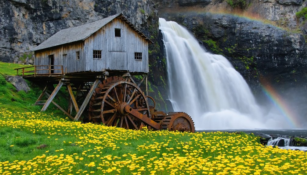
Sumpter Valley Dredge State Heritage Area: Gold Rush Mining Legacy
Gold fever transformed Sumpter, Oregon in 1862 when prospectors struck their first lucky finds, but the real treasure remained hidden beneath the Powder River valley‘s surface long after easy pickings vanished.
You’ll discover the ingenious solution at Sumpter Valley Dredge State Heritage Area—a massive 1935 mining technology marvel with 72 one-ton buckets that devoured eight miles of valley floor, extracting $180 million worth of gold at today’s prices.
The engineering’s impressive, though you’ll notice the environmental cost: ten-foot tailings piles snake across the landscape, visible even from space.
While environmental restoration efforts have gradually healed portions of this scarred terrain, the towering dredge stands as both monument and warning.
Explore the 93-acre heritage site freely—its weathered machinery tells unvarnished stories of ambition’s price.
Champoeg State Park: Where Oregon Territory Was Born
You’ll stand where 52 pioneers voted 52-50 on May 2, 1843, to establish the first American provisional government on the Pacific Coast—a decision that swung on just two French-Canadian fur trappers who broke from the Hudson’s Bay Company.
The Robert Newell House, preserved among the oaks and meadows, lets you walk through the actual home of one of the town’s founders who witnessed Champoeg’s rise to 200 residents and its complete destruction in the catastrophic 1861 flood.
Spring brings wildflowers across the fields where the Willamette Post once stored wheat and politicians debated Oregon’s future, making it the perfect season to explore this birthplace of territorial government.
Historic 1843 Provisional Vote
Picture yourself standing on the grassy banks of the Willamette River in early May 1843, where a crowd of settlers gathered at Hudson’s Bay Company’s granary to cast one of the most consequential votes in Pacific Northwest history.
The 1843 voting resulted in a razor-thin 52-50 decision favoring a provisional government aligned with the United States rather than remaining independent or under British influence.
What made this moment pivotal:
- First self-governed territory west of the Rocky Mountains
- Settlers chose their own destiny without waiting for distant governments
- Nine representatives immediately began drafting civil codes
- This vote ultimately shaped Oregon’s path to statehood in 1859
You’re walking through the exact location where ordinary pioneers claimed their right to self-determination, fundamentally changing the West’s political landscape.
Robert Newell House Tour
Just a short drive from that historic voting ground, you can step inside the two-story Robert Newell House, perched on a hillside overlooking the Willamette River where it has stood since 1852.
This revival-style home showcases remarkable architectural significance—it’s the only structure that survived Champoeg’s devastating 1861 flood, when all 200 townspeople fled to its elevated sanctuary.
You’ll explore rooms filled with mid-19th century artifacts: hand-spun textiles, pioneer furniture, and Native American baskets that tell stories of self-reliance.
The DAR operates this museum from March through October, and you’ll also discover a historic schoolhouse and jail on the grounds.
Walk these wooden floors where pioneer heritage comes alive, reminding you that freedom-seekers once carved their own path through these western valleys.
Willamette Valley Heritage Sites: Multiple Historic Settlements in One Journey
The Willamette Valley cradles Oregon’s most concentrated collection of ghost towns, where a single day’s drive reveals the state’s transformation from pioneer territory to modern farmland.
Oregon’s ghost towns map a century of change, from riverboat landings to vanished grain warehouses, all within reach of a single tank of gas.
You’ll trace the riverboat era through Champoeg’s historic parklands and Linn City’s submerged foundations, both claimed by the Great Flood of 1862. Fairfield’s cemetery stands alone among working fields, its 1852 grain warehouse long consumed by flames.
Essential stops for your valley exploration:
- Champoeg State Park offers interpretive trails through Oregon’s governmental birthplace
- Linn City’s remnants hide within West Linn’s modern boundaries
- Fairfield’s abandoned buildings exist only in local legends—just the cemetery remains
- Jawbone Flats combines mining relics with old-growth forest access
Pack hiking boots and historical curiosity. These settlements demand off-pavement exploration where freedom meets frontier history.
White River Falls State Park: Natural Beauty Meets Industrial History
While valley settlements whisper their stories through cemeteries and park trails, White River Falls roars its history across 90 feet of volcanic basalt in Oregon’s high desert country.
You’ll find Oregon’s “mini-Niagara” 35 miles south of The Dalles, where milky glacial waters once powered one of the state’s first hydroelectric plants.
Trek the quarter-mile trail to explore crumbling powerhouse ruins from 1910, their generators frozen in time since decommissioning in 1963.
Spring’s the sweet spot—high flows transform the falls into thundering spectacle while desert wildflowers blanket the canyon.
Watch for wildlife encounters along the trail’s geological formations, where volcanic rock reveals ancient eruptions.
The park’s open year-round without fees, though amenities close mid-October through March.
Pack water; this high desert doesn’t coddle visitors.
Planning Your Spring Ghost Town Adventure in Oregon
Before you pack your camera and point your truck toward Oregon’s abandoned settlements, understand that spring exploration demands different preparation than summer road trips. Eastern sites like Granite reward patience—snowpack lingers until May. But late-season visits reveal spring wildflowers pushing through foundation cracks against stunning mountain scenery.
Patience pays off when wildflowers reclaim forgotten foundations, but spring ghost town photography means preparing for snowpack and mud.
You’ll need high-clearance 4WD for Greenhorn’s 6,000-foot elevation and Bourne’s forest service roads, where post-thaw mud tests your suspension.
Essential preparations for spring ghost town adventures:
- Download offline maps for Blue Mountains signal-dead zones
- Layer clothing for 40-60°F days and freezing nights
- Carry extra fuel for remote eastern Oregon drives
- Pack waterproof gear for western areas like Bridal Veil
Watch for abandoned mine shafts in deteriorating structures.
Verify road conditions through forest service updates before committing to remote locations.
Frequently Asked Questions
Are Dogs Allowed at Oregon Ghost Town Sites and State Parks?
You’ll find pets allowed at Oregon’s BLM ghost towns with minimal leash requirements, giving you freedom to explore. However, state parks enforce stricter six-foot leash rules, and some trails prohibit dogs entirely, so check ahead.
What Cell Phone Coverage Can Visitors Expect in Remote Ghost Towns?
You’ll find cell phone signal practically vanishes into thin air out there! Verizon offers your best bet for coverage limitations in remote ghost towns, though you should pack satellite communication backups for true off-grid eastern Oregon adventures.
Do Any Ghost Towns Offer Overnight Camping or Lodging Options Nearby?
You’ll find overnight options near several ghost towns—Cornucopia Lodge offers cozy accommodations amid haunted history, while Shaniko provides 320+ campsites. These spots deliver excellent photography opportunities at dawn, capturing misty landscapes and weathered buildings in spring’s perfect light.
Are Oregon Ghost Town Sites Accessible for Visitors With Mobility Limitations?
While many ghost towns sit on rugged terrain, Oregon’s accessibility verification program identifies several with wheelchair friendly pathways. You’ll find accessible trails leading to Eastern Oregon’s historic sites, letting you explore freely without mobility barriers limiting your adventure.
In addition to exploring Oregon’s historic ghost towns, visitors can immerse themselves in the captivating stories of the past. Many of these towns offer guided tours that highlight their unique histories and the people who once called them home. As you wander through the remnants of lost eras, you’ll gain a deeper appreciation for the state’s rich heritage.
What Safety Precautions Should Visitors Take When Exploring Abandoned Structures?
You’ll need sturdy boots, respirators, and flashlights when entering hazardous structures. Test floors carefully, stay near walls, and respect preservation rules—don’t remove artifacts. Always bring a buddy, scout exits first, and obtain permission before exploring private property.
References
- https://traveloregon.com/things-to-do/culture-history/ghost-towns/oregon-ghost-towns-and-new-beginnings/
- https://www.pdxmonthly.com/travel-and-outdoors/2019/02/10-kitschy-roadside-attractions-to-visit-in-oregon
- https://en.wikipedia.org/wiki/List_of_ghost_towns_in_Oregon
- https://www.tripadvisor.com/Attractions-g28958-Activities-c47-t14-Oregon.html
- https://wvheritage.wordpress.com/2024/05/03/spring-out-of-that-easy-chair-and-take-a-ghost-town-tour/
- https://www.youtube.com/watch?v=GaS3xjrQ-_I
- https://www.oregonencyclopedia.org/articles/shaniko/
- https://www.legendsofamerica.com/or-shaniko/
- https://www.kati-explores.com/post/shaniko-oregon
- https://en.wikipedia.org/wiki/Shaniko


