You’ll find Vermont’s ghost towns particularly enchanting in spring when snowmelt reveals hidden cellar holes and wildflowers bloom through weathered foundations. Explore Greenbank’s Hollow along Joe’s Brook for preserved mill ruins, or venture to mysterious Glastenbury where charcoal kilns dot the forest floor. West Castleton’s slate quarry remnants and Ricker Basin‘s abandoned farmsteads offer tangible connections to Vermont’s industrial past. Pack waterproof boots for muddy trails and bring navigation tools since cell service proves unreliable. These forgotten settlements hold countless stories waiting beneath the emerging spring landscape.
Key Takeaways
- Greenbank’s Hollow in Danville features woolen mill ruins best viewed in spring when snowmelt reveals foundations and interpretive signs.
- Glastenbury offers charcoal kilns, railroad grades, and mysterious disappearance legends amid spring forest regrowth in Bennington County mountains.
- Ricker Basin in Little River State Park displays cellar holes, cemeteries, and farmhouse ruins from the 1927 flood evacuation.
- West Castleton’s Slate History Trail showcases quarry ruins, mill foundations, and worker housing remnants with blooming spring wildflowers.
- Somerset maintains extreme isolation with logging-era remnants, requiring navigation tools due to difficult terrain and limited accessibility.
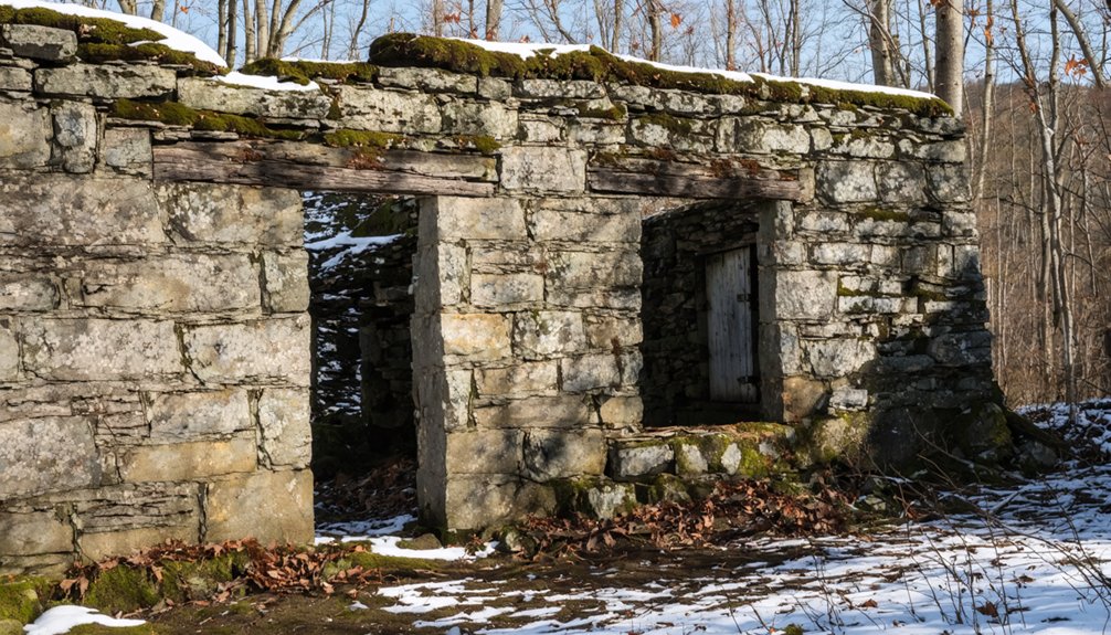
Greenbank’s Hollow: a Preserved Mill Town With Historic Charm
Tucked along the banks of Joe’s Brook in Danville, Greenbank’s Hollow whispers stories of Vermont’s textile heyday through weathered granite foundations and a rebuilt covered bridge. You’ll discover what remains of Benjamin Greenbank’s once-thriving woolen empire, where 700 yards of cloth rolled from looms daily before the devastating 1885 fire.
Spring’s your ideal window—snowmelt swells the brook that once powered three mills, and you’ll spot foundations emerging from receding mud. The Danville Historical Society’s tackled significant preservation challenges here, reconstructing the covered bridge and marking sites with interpretive signs. The five-story factory employed a workforce of around 45 people at its peak, making it a substantial operation for the era.
Though urban legends about phantom mill workers persist, the real magic lies in visible cellar holes dotting the riverbanks. The site sits in southern Danville within Vermont’s Northeast Kingdom region, where Greenbank had constructed not just mills but an entire community infrastructure. Visit during January’s commemorative bonfire if you’re chasing authentic community connection.
Glastenbury: The Mysterious Abandoned Lumber Settlement
Deep in Bennington County’s mountains, Glastenbury sprawls across terrain so forbidding that Indigenous peoples considered it cursed long before settlers arrived.
Glastenbury’s mountains earned their cursed reputation centuries before settlers attempted—and failed—to tame the unforgiving wilderness.
You’ll discover remnants of two settlements—Fayville and South Glastenbury—where 250 residents once operated dozens of charcoal kilns during the 1880s logging boom. When timber vanished within a decade, entrepreneurs built a mountain resort that lasted just one season before catastrophic floods destroyed it in 1898.
Today’s urban exploration reveals crumbling foundations, old railroad grades, and kiln sites reclaimed by forest. The town officially dissolved in 1937 with seven remaining residents. The Bennington-Glastenbury Railroad, constructed in 1872, climbed an impressive 250 feet per mile over nine miles to support the logging operations. Between 1945 and 1950, the area gained notoriety when several people mysteriously vanished without explanation, contributing to Glastenbury’s haunted reputation.
Spring’s mild weather makes hiking these abandoned sites ideal, though you’ll need proper boots and navigation tools. Historic preservation efforts remain minimal here—nature’s reclaiming what industry abandoned, creating Vermont’s most atmospheric ghost town experience.
As you venture into these abandoned sites to explore in Vermont, you’ll uncover fascinating remnants of the past, each telling a unique story. The juxtaposition of crumbling structures against Vermont’s stunning natural backdrop offers a hauntingly beautiful experience. Be sure to bring a camera to capture the eerie yet captivating landscapes that await you.
Somerset: Hidden Ruins in the Green Mountain National Forest
Where Vermont’s wilderness turns genuinely hostile, Somerset emerges—or rather, fails to emerge—from the Green Mountain National Forest‘s densest reaches. You’ll know you’ve arrived when pavement surrenders to punishing gravel and power lines abruptly vanish behind you.
This disincorporated town maintains a year-round population of two souls supervising 36 square miles of unbroken forest.
The bullet-riddled speed limit sign at the town line tells hidden stories about Somerset’s defiant spirit.
Navigate carefully through these deep woods where ancient artifacts from logging days lie scattered among perennial tree fall. The area was settled around the 1880s when logging operations stripped the mountainsides bare, sending timber down the Deerfield River to distant mills.
The constantly shifting winds will disorient you—pack a compass and inform someone of your plans.
Spring offers the clearest trails, but don’t underestimate terrain that’s swallowed hikers whole. Nearby Glastenbury shares Somerset’s isolation, its observation tower crowning a 3,748-foot peak among Vermont’s highest summits.
Somerset demands respect, rewarding only the prepared.
Ricker Basin: Stone Cellars and Forgotten Footpaths
Rising from the southeastern slopes of Ricker Mountain, the vanished community of Ricker Basin tells its story through stone—cellar holes that once cradled fifty families before Vermont’s deadliest natural disaster erased them from the map.
You’ll find these forgotten foundations scattered throughout Little River State Park, where spring hiking reveals black cherry trees standing sentinel beside crumbling stonewalls.
The 1927 flood—which claimed over fifty lives and caused damages worth half a billion today—triggered the community’s final exodus.
When Waterbury Dam‘s reservoir submerged what remained, urban legends took root among the ruins.
Today’s preservation challenges mean you’re racing time itself. Follow overgrown town roads to discover Almeran Goodell‘s dilapidated farmhouse, cemetery plots, and sugar maples marking old sugaring operations.
The Ricker Cemetery holds graves of original settlers, including Florence Ricker, who died exactly seventy-five years after her birth.
Joseph Ricker founded the settlement in 1816 as a farm community that would later grow with the railroad’s arrival.
Post-winter visits offer clearest access before vegetation reclaims these liberation-era paths.
Smith Family Farms: Tracing Agricultural Heritage Through Foundations
- Stone foundations from 1970s dairy operations frame current livestock facilities.
- Original pasture systems adapted for rotational grazing.
- Heritage barn structures repurposed for modern pork production.
- Walking trails through managed forestland showcase sustainable practices.
- The farm’s conservation easement protects 265 acres from development while maintaining agricultural use.
- Historic maple sugar groves once contained over 1,200 trees producing thousands of pounds annually.
Spring visits reveal muddy boot-prints connecting past to present, where working farms become living monuments.
West Castleton: Where History Meets State Park Beauty
You’ll find West Castleton’s slate quarries and mill foundations woven seamlessly into Bomoseen State Park’s trail system, where spring wildflowers push through century-old cellar holes.
I’ve walked the Slate History Trail dozens of times, and April transforms the abandoned village—trilliums bloom beside rusted machinery, and maple saplings frame views of the very quarries that once employed hundreds.
Pack sturdy boots for scrambling over slate heaps near Cedar Mountain, bring a trail map to locate the scattered ruins, and allow two hours to properly explore the foundations tucked between the lakes.
Historic Town Remnants Preserved
Tucked between Glen Lake and Lake Bomoseen, the ghost town of West Castleton tells its story through scattered foundations and weathered slate ruins that emerge from tangles of grape vines and goldenrod. You’ll discover these archaeological sites within Bomoseen State Park, where industrial history speaks through silent remnants of Vermont’s once-thriving slate empire.
As you explore, watch for:
- Cellar holes marking where 43 worker houses once stood
- Quarry gables and mill foundations along Glen Lake’s shore
- The massive slate heap on Cedar Mountain, visible from Lake Bomoseen’s eastern shore
- Foundations along Moscow Road and Black Pond Road where immigrant families lived
Archaeologists like Sally Hight have documented these landmarks extensively, preserving evidence of 19th-century industrial ambition before nature reclaims it completely.
Bomoseen State Park Access
When spring thaws reveal West Castleton’s slate ruins within Bomoseen State Park‘s 3,576 acres, you’re stepping into one of Vermont’s most accessible ghost towns.
You’ll find the park at 22 Cedar Mountain Road in Castleton, open Memorial Day through Labor Day weekends.
Follow the history trail to explore railroad history dating to 1850, when tracks first connected this company town to Lake Bomoseen’s shores.
Slate extraction remnants dominate the landscape—towering rubble piles on the western shore, Cedar Mountain’s massive slate heap visible across the water, and stone ruins of the main mill that once processed Vermont’s second-largest slate production.
You’ll discover the foreman’s duplex foundation, quarry holes hidden among saplings, and cellar depressions marking where 43 workers’ houses stood before 1929’s closure freed this land from industrial control.
Spring Trail Exploration Options
The Slate History Trail winds through West Castleton’s forgotten streets each spring, transforming your hike into a time-traveler’s journey where crimson trilliums push through century-old cellar holes and sugar maples shade the foreman’s duplex foundation.
You’ll discover industrial archaeology at its most accessible—no permits required, just curiosity and sturdy boots.
Essential Trail Discoveries:
- Cedar Mountain quarries where immigrant workers extracted metamorphic slate from ancient ocean sediments
- Glen Lake mill ruins wrapped in wild grapevines and goldenrod
- Moscow Road foundations marking 43 vanished homes along the company corridor
- Lake Bomoseen overlook where local folklore places the phantom rowboat on full-moon nights
Archeologist Shelly Hight calls these sites “Vermont slate history moments”—unguarded chapters you’ll interpret without velvet ropes limiting your exploration.
Spring reveals what winter concealed.
Planning Your Spring Ghost Town Adventure in Vermont
Before you set out to explore Vermont’s abandoned settlements, pack waterproof boots—I learned the hard way that mud season transforms Ricker Basin’s trails into ankle-deep slicks by mid-April.
Your daypack should include paper maps (cell service vanishes near Glastenbury and Somerset), extra layers for unpredictable mountain weather, and a first-aid kit for those rough bushwhacks to cemetery sites.
Download offline maps at home, check Vermont State Parks’ website for seasonal road closures, and always tell someone your planned route before heading into remote areas where vandalized structures and wildlife encounters demand extra caution.
Essential Gear and Preparation
Vermont’s spring mud season transforms even short hikes into slippery adventures, so you’ll want to layer up before heading out to explore abandoned settlements. Pack these essentials for traversing overgrown trails to forgotten cemeteries and stone-walled homesteads:
- Sturdy waterproof boots for rock-strewn hillsides and muddy 1-2 mile ascents
- Three-layer clothing system with moisture-wicking base, insulating middle, and Gore-Tex outer shell for temperature swings from 30s to 60s
- Map, guidebook, water, and snacks for remote areas like Glastenbury Wilderness
- Binoculars and camera for capturing wildflower blooms around cellar holes and documenting birdwatching hotspots near historic sites
Don’t forget insect repellent for forest regrowth areas.
Check Trailfinder.info before venturing out, and stick to south-facing slopes below 2,500 feet for ideal trail conditions.
While Vermont’s abandoned settlements beckon from hillsides and hollows, reaching them requires more strategy than plugging coordinates into your GPS. Glastenbury’s trails follow old railroad beds but you’ll lose the path—I did—where former routes converge at river swimming holes. Pack a compass for Copperfield’s orientation challenges, and expect waist-high growth when bushwhacking Glastenbury’s ski trails using rusted chairlift cables as markers.
Wildlife encounters intensify during spring mating season, so make noise on Ricker Basin’s long inclines.
Trail navigation demands awareness: Barre’s granite quarries hide beneath revegetation, while mud-slicked paths test your footing during melt season. Check state park updates before departing.
Green Mountain National Forest restricts vehicles, mandating foot travel only. Dawn-to-dusk windows at conserved forests aren’t suggestions—they’re your legal limits for exploration.
Frequently Asked Questions
Are Pets Allowed When Exploring Vermont’s Ghost Town Sites in Spring?
You’ll find no documented pet policies or dog restrictions at Glastenbury’s abandoned settlements. Your four-legged explorer can freely roam these wild trails, but prepare for challenging spring terrain that demands experience and proper gear for both of you.
Do I Need Special Permits to Photograph These Abandoned Locations?
Like the Wild West frontier, you’re free to shoot away—Vermont doesn’t require general filming permits. However, permission requirements and photography regulations kick in for commercial work, needing insurance proof and special permits on federal lands.
What Safety Equipment Should I Bring When Visiting Ghost Towns?
You’ll need sturdy boots, gloves, and a headlamp for exploring safely. Respect preservation efforts by not disturbing historical artifacts. Bring a first aid kit, water, and tell someone your plans—Vermont’s ghost towns reward prepared adventurers.
Are There Guided Tours Available for Vermont’s Abandoned Settlements?
Vermont doesn’t offer guided tours of actual abandoned settlements, but you’ll find ghost walks exploring local legends and historical preservation through Montpelier, Burlington, and St. Johnsbury’s haunted sites. These tours capture Vermont’s mysterious past through spirited storytelling.
Can I Camp Overnight Near These Historic Ghost Town Sites?
You can camp near ghost town sites, but you’ll need to follow camping regulations that vary by land ownership. Check permitted zones, respect distance requirements, and note any pet restrictions before pitching your tent in these historic wilderness areas.
References
- https://kids.kiddle.co/List_of_ghost_towns_in_Vermont
- https://www.youtube.com/watch?v=2fvPo9iQC-w
- https://greenmountainpeaks.com/2025/10/16/top-haunted-locations-in-vermont-for-brave-souls/
- https://www.onlyinyourstate.com/experiences/vermont/ghost-town-vt
- https://www.geotab.com/ghost-towns/
- https://myfamilytravels.com/supposedly-boring-vermont-towns-hiding-some-truly-strange-landmarks
- https://obscurevermont.com/tag/ruins/
- https://www.atlasobscura.com/places/the-forgotten-village-at-greenbanks-hollow-danville-vermont
- https://www.hmdb.org/m.asp?m=61392
- https://preservationinpink.wordpress.com/2015/09/18/the-forgotten-village-greenbanks-hollow/


