You’ll find Arkansas’s most accessible ghost towns come alive during summer droughts, when Monte Ne’s submerged amphitheater emerges from Beaver Lake and Rush’s zinc mining ruins bask in extended daylight. Head to Calico Rock’s weathered storefronts along the White River, or venture deeper into Ozark National Forest to discover Bonanza’s isolated cabins. July and August offer the best viewing conditions—just pack sturdy boots, plenty of water, and your camera, because these abandoned settlements reveal their secrets when you know exactly when and how to explore them.
Key Takeaways
- Rush offers interpretive trails through 1880s zinc mining ruins along Buffalo National River, with extended summer daylight for thorough exploration.
- Monte Ne’s submerged ruins surface during July-August droughts when Beaver Lake recedes below 1,094 feet, ideal for kayaking or hiking.
- Calico Rock Ghost Town District provides free access to weathered storefronts and historic buildings along the White River year-round.
- Summer visits require sturdy boots, hydration, sun protection, and early morning trips to avoid heat while exploring remote locations.
- Check lake levels via Army Corps of Engineers data before visiting Monte Ne; never enter mine shafts or unstable structures.
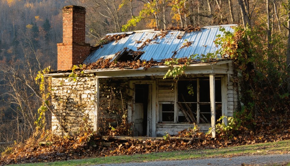
Rush: A Mining Town Frozen in Time
Deep in the Ozark Mountains along Rush Creek, a once-thriving zinc mining community stands silent, its weathered buildings and rusted equipment telling stories of boom and bust. You’ll discover abandoned architecture at every turn—from the massive Morning Star Mine quarry to skeletal mill structures that once processed ore for World War I.
Weathered zinc mining ruins emerge from the Ozarks—silent monuments to boom-and-bust days when ore fueled a World War.
This 1,300-acre historical preservation site within Buffalo National River lets you wander freely among ruins dating back to the 1880s. Start at the Rush campground parking area, where interpretive trails guide you past the smelter, processing facilities, and waste piles. The stone remains of the 1903 Hicks Property offer a glimpse into the daily operations of families who once called this mining district home.
The terrain’s rugged—rocky paths, elevation changes, river views—so wear sturdy boots. Wildlife roams freely here: deer, turkeys, countless birds. At its peak during World War I, the town swelled to 2,000-5,000 residents as zinc demand skyrocketed.
Just remember: never enter mine shafts. They’re deadly traps.
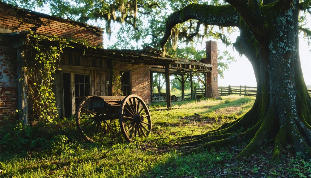
Monte Ne: The Sunken Resort That Rises Again
You’ll find William Hope Harvey’s extravagant 1900s resort beneath Beaver Lake’s surface, where ornate stone foundations and a massive amphitheater emerge like Atlantis during summer droughts.
When water levels drop below 1,094 feet, you can walk through Missouri Row’s limestone basement and trace the walls where Harvey once entertained guests with Arkansas’s first golf course and indoor pool.
The resort’s builder, known as “Coin” Harvey, gained fame as author of the nation’s second bestselling book after the Bible before turning his attention to developing this Ozarks getaway.
Harvey’s most enduring legacy is his tomb, which stands as the best-preserved structure from the entire Monte Ne complex.
Plan your visit during severe drought years—the lake’s recession reveals more of this sunken dream with each dropping foot.
Harvey’s Ambitious Resort Vision
What drives a man to build the world’s largest log structures in the remote Ozark hills? For “Coin” Harvey, it was pure ambition and the desire to preserve his ideals through history.
After William Jennings Bryan’s 1896 defeat, Harvey transformed 320 acres into Monte Ne—a resort demonstrating remarkable architectural significance through Missouri Row and Oklahoma Row‘s three-story log construction.
You’ll discover innovations that defined freedom in leisure:
- Arkansas’s first indoor heated swimming pool with slides and springboards
- The state’s inaugural golf course for pioneering sportsmen
- A 50-foot Venetian gondola with imported gondoliers teaching locals
- A dedicated 5-mile narrow-gauge railroad connecting civilization to wilderness
Harvey’s vision included a massive pyramid designed to preserve messages for future generations, though financial constraints left only foundations and an amphitheater standing. The resort drew its initial success from Health Springs water, which Harvey renamed from Silver Springs and promoted as having rare healing properties for visitors seeking wellness. Harvey’s wealth from silver mining in Colorado financed this ambitious development and allowed him to promote his political views through the resort’s infrastructure.
Submerged by Beaver Lake
When the U.S. Army Corps of Engineers built Beaver Dam in 1962, they miscalculated their survey—purchasing and dismantling hotels while the lake consumed most of Monte Ne’s ruins by the late 1960s.
You’ll find Oklahoma Row’s foundation and basement still standing, along with Missouri Row’s fireplace and chimney. Limestone structures dot the boat launch area, remnants of Harvey’s grand vision.
The real magic happens during droughts. Like Brigadoon, the resort materializes when water levels drop markedly, revealing the amphitheater and pyramid retaining wall for underwater explorations.
Scuba divers can navigate submerged structures year-round, but you’ll want to visit during low lake visibility periods for ideal viewing. Bridges crossing the Lagoon remain submerged alongside the other ruins, visible only when water levels recede.
The Oklahoma Row tower stood sentinel until 2023, when engineers removed it as a safety hazard. For those who can’t dive, exhibits in Rogers showcase relics and artifacts from Monte Ne’s glory days as one of the largest resorts of its time.
Best Drought Viewing Times
Like a ghost that chooses its own haunting schedule, Monte Ne’s ruins reveal themselves only when nature cooperates—and timing your visit requires understanding Beaver Lake’s temperamental moods.
Historical drought patterns show the amphitheater and pyramid walls emerge during Arkansas’s scorching summers, particularly July through August when evaporation peaks. You’ll want to practice water level monitoring through the US Army Corps of Engineers’ real-time data—target readings noticeably below normal pool elevation for ideal exposure. The resort once thrived five miles southeast of Rogers in Benton County before Beaver Dam’s construction created the lake that swallowed it.
Maximize your Monte Ne expedition:
- Check lake levels weekly during drought periods to catch the ruins’ brief appearances
- Combine boat launch access with hiking boots for exploring exposed limestone foundations
- Visit Rogers Historical Museum first to contextualize the submerged structures you’ll witness
- Consider scuba diving when surface conditions disappoint—the ruins wait beneath regardless
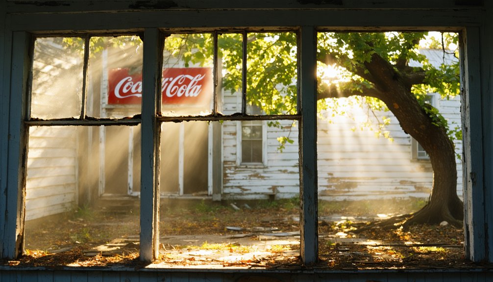
Calico Rock Ghost Town District: Where Past Meets Present
Tucked along the banks of the White River, the Calico Rock Ghost Town District stands as one of Arkansas’s most accessible time capsules—a place where weathered storefronts and century-old brick buildings transport you straight into the rough-and-tumble era of frontier commerce.
You’ll walk streets where “Peppersauce” moonshine once flowed freely through alleys and gunfights settled disputes. The historical architecture tells community stories of resilience—merchants rebuilt with brick after flames consumed their wooden structures in 1923.
Where moonshine deals went down and lead settled arguments, brick rose from ashes to tell frontier tales of survival.
Check out the tiny cement jail that somehow crammed twenty rowdy souls inside on Saturday nights.
Today’s restored district offers unrestricted exploration without tourist traps or admission fees. You’re free to photograph crumbling facades, peer through dusty windows, and imagine zinc miners stumbling from saloons onto muddy boardwalks. Among the approximately 20 buildings that still stand, you’ll discover remnants of the old cotton gin, funeral parlor, and telephone exchange—each structure adding another layer to this frontier town’s colorful past.
Old Davidsonville: Arkansas’s First County Seat

Where else can you stand in a quiet riverside meadow and walk the exact streets where Arkansas first tested the machinery of American government? Old Davidsonville, established in 1815, hosted the territory’s first post office, land office, and courthouse before vanishing by the 1830s.
Today’s state park preserves this ghost of frontier ambition through careful preservation efforts that maintain the town’s grid without erasing its wild character.
Your visit checklist:
- Wade the Black River where ferries once crossed the Southwest Trail
- Search grassy commons for historical artifacts near the original courthouse site
- Walk the laid-out streets where Stephen Austin practiced law before founding Texas
- Explore 163 acres where Native Americans, French settlers, and American pioneers shaped Arkansas’s birth
You’ll find freedom in how completely nature reclaimed civilization’s first Arkansas foothold.
Zinc: Remote Mining Remnants in the Ozarks
Walk the interpretive loop through town center, where the 1886 ore smelter—oldest surviving structure—stands sentinel over vanished dreams.
The 1886 ore smelter stands as the town’s oldest survivor, a stone monument to prosperity long since turned to dust.
The blacksmith shop remembers when wagons groaned under ore loads destined for White River barges.
By 1969, only two holdouts remained.
Zinc mining here outperformed Missouri and Kansas deposits, fueling four distinct booms before silence reclaimed the creeks.
Today’s trails follow mining levels above abandoned streets, offering solitary exploration through authentic remoteness.
Bonanza: Hidden Treasure in Ozark National Forest
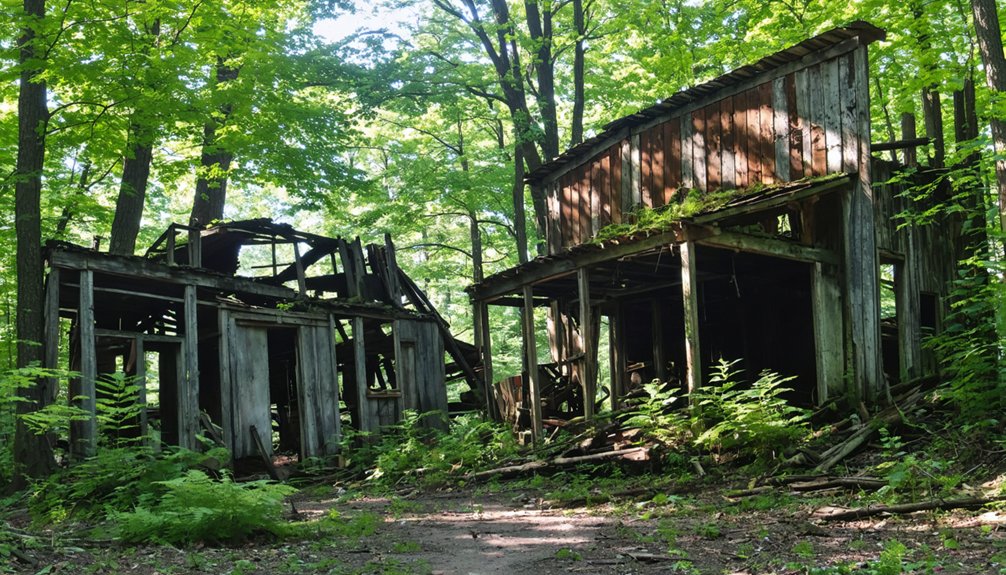
Deep in the Ozark National Forest’s tangled hollows, Bonanza guards its secrets behind miles of punishing dirt roads that’ll test your vehicle’s clearance and your resolve. This coal mining settlement’s collapsed cabins and rusted equipment scatter across hillsides where tight-knit families once carved out lives in unforgiving terrain.
The Central Coal and Coke Company’s 1937 store fire erased most commercial structures, leaving authentic ruins untouched by commercialization.
What makes Bonanza worth the trek:
- Historical preservation through isolation—remoteness protects crumbling structures from vandalism
- Local legends echo through abandoned shafts and weathered foundations
- Zero crowds—you’ll explore solo, experiencing genuine discovery
- Summer accessibility—dry conditions improve treacherous approach roads
Pack out everything you bring. These ruins survive because adventurers respect their fragility.
Best Times to Visit Arkansas Ghost Towns in Summer
Arkansas’s summer heat transforms ghost town exploration from muddy slog to strategic adventure—if you time it right. Target early fall when temperatures drop but water levels remain low, exposing Monte Ne’s submerged concrete towers—normally hidden beneath Beaver Lake. Drought summers reveal ruins perfect for kayaking around otherwise inaccessible structures.
Plan morning expeditions to Rush Historic District before midday heat peaks, then cool off in Buffalo River’s swimming holes. Pack bug spray religiously; June’s humidity breeds relentless mosquitoes after wet springs.
Summer camping near ghost towns extends your freedom to explore multiple sites. Early mornings reward wildlife watching enthusiasts—hummingbirds frequent abandoned structures while chipmunks navigate crumbling foundations.
Extended daylight hours eliminate rushed schedules, letting you photograph weathered buildings bathed in golden-hour light without time constraints.
What to Bring on Your Ghost Town Adventure

Exploring abandoned buildings under Arkansas’s relentless summer sun requires you to pack strategically—I learned this the hard way after my water ran out halfway through photographing Rush’s crumbling zinc mines.
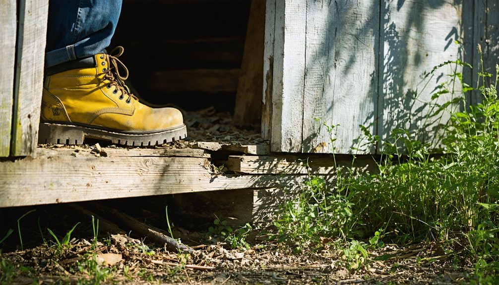
You’ll need sturdy boots for traversing debris-strewn floors, a reliable camera to capture peeling wallpaper and forgotten storefronts before they vanish, and enough water to prevent heat exhaustion in these shadeless ruins.
Your backpack should balance documentation tools with survival essentials, because ghost towns don’t offer convenience stores when you’ve forgotten sunscreen or your phone battery dies.
Essential Hiking and Safety Gear
Before you set foot into Arkansas’s abandoned settlements, you’ll need gear that transforms a risky venture into a manageable adventure. Urban exploration demands preparation—these ghost towns hide unstable structures and overgrown trails that test even experienced wanderers.
As you embark on your journey to explore ghost towns in Arkansas, remember to prioritize your safety and stay aware of your surroundings. These once-thriving communities offer a glimpse into the past, with crumbling buildings and remnants of lives once lived waiting to be discovered. Take your time to appreciate the history and stories behind each site, as the adventure is as much about the exploration as it is about the places themselves.
Your essential kit should include:
- Sturdy boots and layering system – Weathered floorboards and sudden summer storms won’t respect sneakers or cotton tees
- Headlamp with backup batteries – Collapsing roofs create pitch-black spaces where your phone’s flashlight won’t cut it
- First-aid kit and emergency shelter – Historical preservation sites lack ranger stations and cell service
- Navigation tools and GPS device – Faded roads disappear into Arkansas wilderness faster than you’d expect
Pack a multi-tool for forcing stuck doors, water filtration for forgotten springs, and weatherproof layers.
Freedom means self-reliance when concrete crumbles beneath your feet.
Photography and Documentation Equipment
The right camera gear separates forgotten memories from images that capture decay’s haunting beauty. You’ll want a full-frame DSLR like the Nikon D750 paired with a 16-35mm f/2.8L for sweeping interiors and collapsed structures. Pack a sturdy tripod—essential for bracketing HDR shots in dim saloons and sun-bleached doorways.
Your 70-200mm f/2.8L isolates weathered details from safe distances, while circular polarizers cut glare on shattered windows.
Bring shoe-mount flashes with wireless triggers for illuminating dark corners. A sensor cleaning kit combats Arkansas’s pervasive dust.
Check drone regulations before launching—many historic sites restrict aerial photography. For archival preservation, shoot RAW files and document GPS coordinates.
That fast 50mm f/1.8 excels in low-light scenarios when documenting crumbling evidence of lives once lived.
Weather Protection and Hydration
Arkansas’s summer sun transforms abandoned settlements into furnaces where metal roofs radiate waves of heat and exposed foundations bake under cloudless skies. You’ll need serious hydration stations—multiple water bottles aren’t optional when exploring Rush’s vine-choked ruins or Monte Ne’s drought-exposed remnants.
I’ve learned the hard way that one bottle won’t cut it when cell service vanishes and shade becomes a luxury.
Essential gear for beating the elements:
- Sun protection arsenal: Wide-brimmed hat, UV-blocking sunglasses, and high-SPF sunscreen
- Hydration stations: Three water bottles minimum plus electrolyte packets
- Cooling layers: Lightweight long sleeves in moisture-wicking fabric
- Emergency supplies: First aid kit with heat-treatment items
Early morning explorations grant you freedom from afternoon brutality. Pack smart, stay hydrated, and these ghost towns reveal their secrets without roasting you alive.
Safety Tips for Exploring Abandoned Sites
While ghost towns whisper stories of Arkansas’s past, they also harbor real dangers that demand your respect and preparation. Structural hazards lurk everywhere—rotted floors collapse without warning, mine shafts yawn in overgrown clearings, and rusted debris shifts underfoot. I learned this exploring Rush’s zinc mining remnants, where a seemingly solid foundation crumbled beneath my boot.
Wildlife encounters intensify in summer heat. Black bears, venomous snakes, and aggressive insects thrive in these abandoned spaces. Wear sturdy boots, pack a thorough first aid kit, and bring extra water—dehydration strikes faster than you’d expect in the Ozarks’ humidity.
Most critically, respect property boundaries. Download offline maps before venturing out, as cell service vanishes. Never enter enclosed structures alone, and remember: those crumbling walls aren’t Instagram backdrops—they’re genuine hazards.
Frequently Asked Questions
Are Pets Allowed at Arkansas Ghost Town Sites?
Wondering if your furry friend can explore abandoned ruins? Pet policies aren’t explicitly listed for Arkansas ghost town sites, so you’ll need to contact each location directly. However, nearby picnic areas at state parks typically welcome leashed dogs.
Can I Camp Overnight Near These Ghost Town Locations?
You’ll find overnight camping only at Rush Ghost Town’s primitive campground. Remember campfire safety in these dry historic areas, and respect historical preservation regulations—they protect your freedom to explore these vanished communities for generations to come.
Do I Need Special Permits to Photograph Ghost Town Ruins?
You won’t need photogrammetry permits for personal ghost town photography in Arkansas. Historical site access stays pleasantly open on most abandoned locations. However, if you’re shooting commercially with professional equipment or planning to sell images, you’ll need proper permissions.
In addition to exploring forgotten places, ghost towns hosting events in Arkansas can provide unique opportunities for networking and learning about local history. These events often attract a diverse crowd, allowing photographers to capture both the eerie beauty of the sites and the vibrant atmosphere created by attendees. Engaging with locals can also lead to valuable insights and stories that enhance your visual narrative.
Are Guided Tours Available at Any Arkansas Ghost Towns?
Guided tour availability is limited at Arkansas ghost towns. You’ll find self-guided walks at Calico Rock, but organized tours focus on historical preservation in living towns like Eureka Springs and Hot Springs, where you’re free to explore haunted histories independently.
Exploring ghost towns in Arkansas offers a unique glimpse into the past, where remnants of old buildings and faded memories weave an intriguing narrative. Each location has its own stories of ghostly encounters and local legends that captivate history enthusiasts and adventurers alike. As you wander through these forgotten places, the sense of history can be both haunting and exhilarating.
Among the many ghost towns to explore in Arkansas, you may stumble upon the remnants of abandoned structures and intriguing artifacts that tell stories of years gone by. Each site invites visitors to imagine the lives that once thrived there, filled with dreams that now echo through deserted streets. Embrace the thrill of discovery as you navigate these eerie landscapes, where every shadow seems to whisper secrets of the past.
Which Ghost Towns Are Wheelchair Accessible?
Like stepping through time’s doorway, Arkansas Post offers your best wheelchair access with paved paths through historical preservation. Rush and Bruno present accessibility challenges on uneven terrain, but you’ll find parking near key structures, letting history meet independence.
References
- https://everafterinthewoods.com/forgotten-ghost-towns-in-arkansas-that-are-eerially-scenic/
- https://www.youtube.com/watch?v=UfdQHTkBTpc
- https://www.barefoottraveler.com/rush.html
- https://www.eurekasprings.com/attractions/
- https://www.tripadvisor.com/Attractions-g28925-Activities-zft12156-Arkansas.html
- https://www.atlasobscura.com/things-to-do/arkansas
- https://onlyinark.com/featured/the-ultimate-arkansas-summer-bucket-list/
- https://www.arkansas.com/articles/ghost-town-rush
- https://encyclopediaofarkansas.net/entries/rush-ghost-town-marion-county-1270/
- https://www.katepantier.com/discover-the-ghost-town-of-rush-arkansas-hidden-historic-gem/