You’ll find Kentucky’s most compelling ghost towns scattered across coal country and drowned river valleys, where summer greenery contrasts dramatically with abandoned structures. Blue Heron’s steel frameworks preserve an authentic Appalachian mining camp along the Big South Fork, while Barthell Coal Camp offers fifteen restored miner homes and a 300-foot mine descent. Paradise vanished completely in 1967, leaving only a cemetery and cooling towers, and Golden Pond survives through weathered markers and concrete relics between the lakes. Each site reveals Kentucky’s industrial past through ruins, legends, and atmospheric landscapes.
Key Takeaways
- Barthell Coal Camp in McCreary County offers overnight stays in fifteen restored miner homes and a 300-foot underground mine descent for exploration.
- Blue Heron (Mine 18) features steel frameworks of an Appalachian coal town with authentic exhibits, oral histories, and a full-scale tipple model.
- Golden Pond’s vanished community is preserved through historical markers, scenic overlooks, concrete relics, and interpretive signage at Land Between the Lakes.
- Paradise Town site includes a cemetery and industrial remnants, though the original town was demolished in 1967 after TVA buyout.
- Summer exploration requires sturdy boots, headlamps, and checking access conditions with local historical societies due to seasonal closures and flood risks.
Cave City: Where Dinosaurs and History Meet
Nestled thirty minutes northeast of Bowling Green off I-65 exit 53, Cave City beckons families with an unexpected pairing: prehistoric giants frozen in time and the world’s longest cave system. At Dinosaur World, you’ll wander self-guided wooded trails where over 150 life-sized dinosaur replicas tower above.
Over 150 life-sized dinosaur replicas await discovery along self-guided wooded trails in this prehistoric wonderland near Kentucky’s famous caves.
Your kids can dig for prehistoric fossils at Uncle Rex’s Gem Mine, keeping five shark teeth or crinoid pieces each. The interactive boneyard sparks imagination while the dino-themed playground offers climbing adventures. These hands-on activities promote learning and discovery while keeping visitors of all ages entertained.
Bring your coolers—there’s no food sales here, just freedom to explore at your pace with leashed dogs welcome. The park features water stations for pets, ensuring your furry companions stay hydrated throughout the visit. The 5,000-square-foot gift shop stocks authentic fossils and geodes.
Open daily 8:30am-6pm at 711 Mammoth Cave Road, this low-tech attraction delivers hands-on discovery without animatronic distractions.
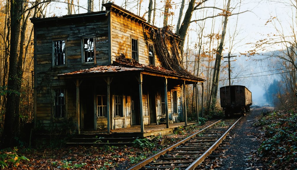
Blue Heron (Mine 18): Steel Ghosts of Appalachian Coal Country
Where else can you walk through the skeleton of a vanished coal town where metal silhouettes stand sentinel over Appalachian memories? Blue Heron, also called Mine 18, offers something extraordinary—ghost structures that outline what once thrived here from 1937 to 1962.
These steel frameworks mark where miners lived, worked, and raised families along the Big South Fork Cumberland River.
You’ll discover authentic coal mining heritage through:
- Full-scale tipple model that processed 120 tons daily
- Preserved mine entrance with interpretive exhibits
- Audio programs featuring oral histories from former residents
- Photo displays inside skeletal home structures
- Original railroad depot framework
This outdoor museum in Big South Fork National River and Recreation Area lets you explore freely, experiencing how isolated company towns shaped Appalachian identity without walls confining the story. The town was founded by Michigan timber baron Justus Stearns, who established the Stearns Coal & Lumber Co. in 1902 after purchasing the land in 1899. Early miners here hand-loaded coal by the ton, with some loading 12-15 tons daily in grueling conditions before mechanization transformed the industry.
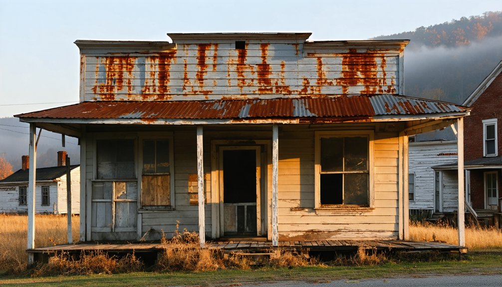
Barthell Coal Camp: Hidden Ruins in the Mountains
You’ll find fifteen restored miner homes nestled in McCreary County’s mountains, where coal families once lived before the camp’s final dismantling in 1961.
The rugged terrain that once challenged workers now offers adventurous summer trails leading through structures like the original company store and schoolhouse. These authentic buildings stand as tangible remnants of Barthell’s 59-year history, waiting for you to explore their weathered walls and imagine the lives lived within them. The camp’s origins trace back to 1902 when L.E. Bryant supervised the initial work on Mine One and Two, establishing the foundation for what would become a thriving mining community. The Koger family’s over $500,000 investment in reconstruction has brought meticulous historical accuracy to the site’s key structures, including the bathhouse, barbershop, and doctor’s office.
Abandoned Miner Family Structures
Deep in McCreary County’s eastern mountains, the Barthell Coal Camp stands as Kentucky’s first mining settlement, established in 1902 by the Stearns Coal and Lumber Company. You’ll discover fifteen renovated miner homes available for overnight stays, offering authentic immersion into coal camp life.
The abandoned infrastructure tells stories of families who lived here until 1959, when foreman Jonce Holt departed as the last resident.
The preserved structures include:
- Company store with original mining technology displays
- Doctor’s office restored to 1902 condition
- Reconstructed schoolhouse where miners’ children learned
- Museum exhibits featuring authentic equipment
- 300-foot mine descent for underground exploration
After the 1943 tipple fire destroyed Mine No. 1, decline accelerated. Today’s restoration lets you experience this vanished world firsthand.
Rugged Summer Trail Access
Seven miles west of Stearns along Highway 742, Barthell Road cuts through McCreary County’s eastern mountains, guiding you toward one of Kentucky’s most secluded historical sites.
Summer hiking here rewards you with trails that wind through rugged terrain to hidden mine entrances and crumbling foundations. You’ll navigate pathways carved into mountainsides, discovering remnants of the 1902 coal operation at your own pace.
Mountain exploration reaches beyond typical tourist barriers—you’re free to venture 300 feet into the actual mine shaft via golf cart, examining authentic equipment and structures up close. The site was reconstructed from old photographs and oral histories by preservationists dedicated to maintaining the camp’s historical integrity.
The Big South Fork region‘s scenic overlooks frame your journey, while ghostly ruins emerge from dense summer foliage, creating an atmosphere that sanitized museums can’t replicate. A 45-minute round-trip on the historic Kentucky Tennessee Railway line offers an alternative way to reach the camp, providing scenic views of the surrounding Appalachian landscape.
Paradise: The Town That Vanished Completely
Along the banks of the Green River, Paradise once thrived as a scenic settlement that lived up to its name—until coal and progress erased it from the map. Founded in the early 1800s, this coal mining community of 800 residents vanished in 1967 when TVA bought out everyone, citing health risks from the Paradise Fossil Plant’s ash fall.
Paradise lived up to its name until coal’s progress erased an entire community from Kentucky’s map in 1967.
Urban exploration here reveals nothing—the entire town was demolished.
What remains for historical preservation enthusiasts:
- A solitary cemetery atop a hill near the power plant
- Industrial surroundings where homes once stood
- Restricted access to the original town site on company property
- Cooling towers marking where Paradise disappeared
- John Prine’s 1971 song immortalizing its destruction
The town’s biblical name originated from Latin paradisus, meaning garden or orchard, an ironic label for a settlement ultimately consumed by industrial development. Just a mile north lies Airdrie Hill, where Scottish immigrants attempted to establish an iron ore business in 1854, operating the furnace for only 8 weeks before boiler failures ended their industrial dream.
You’ll find no structures, just memories of Kentucky’s coal country sacrifices.
Golden Pond: Remnants Between the Lakes
You’ll find Golden Pond’s story told through weathered historical markers standing where moonshine once flowed to Capone’s Chicago speakeasies.
The summer sun warms the concrete mounting blocks—two silent witnesses to 120 years of life before TVA’s 1960s evacuation cleared the land.
Now trails wind through where cafes, pool halls, and grocery stores once clustered, leaving only these fragments and the scenic overlook’s illustrated memory of streets that vanished between the lakes.
Visitor Center Historical Markers
Though the town of Golden Pond vanished decades ago, its memory persists at the Land Between the Lakes Visitor Center, where historical markers and carefully curated displays resurrect what once thrived here.
You’ll discover historic preservation through powerful interpretive signage that reveals the forced evacuation of entire communities.
The center offers:
- Kentucky Historical Society marker documenting the town’s 1882-1969 existence and devastating fires
- Etched glass panels overlaying historical buildings onto today’s landscape
- Scenic overlook featuring a concrete map and period photographs
- Two concrete horse mounting blocks surviving from the original downtown
- Small museum chronicling dam construction’s legacy and displacement
These remnants peel back fifty years of government-mandated progress, honoring the 1.5 million annual visitors who seek understanding of what was sacrificed for recreational development.
Sunlit Pavement and Trails
The shimmer of Golden Pond under summer sun reveals why settlers chose this name—its surface catches afternoon light like molten metal, transforming ordinary water into something that justified a town’s identity.
You’ll find pavement fragments along the old Highway 68/80 corridor, cracked asphalt threading through wilderness where a dozen businesses once thrived. Two concrete mounting blocks stand sentinel in what was downtown—touchstones against urban legends that nothing survived TVA’s transformation.
Trails wind past these remnants, allowing you to trace the town’s footprint through preservation efforts that documented each building’s location before highway construction erased them.
Walk these paths during golden hour when sunlight mirrors the pond’s namesake glow, and you’re experiencing the same luminous phenomenon that defined this community for 120 years.
Bells Mines: Riverside Cemetery in the Wilderness
Deep in the wilderness of northeastern Crittenden County, where the Ohio River winds through Kentucky’s western reaches, Riverside Cemetery stands as a haunting memorial to a vanished coal mining community.
You’ll find headstones dating to the mid-1800s, each revealing Miners’ Tales of European immigrants who worked Bells Mines—Germans, Irish, Welsh, and Scots who sought fortune in Kentucky’s richest coal seams.
The cemetery’s appeal extends beyond Taylor Cemetery’s typical historical markers:
- Simple stone slabs rest beside elaborate marble monuments showcasing classical craftsmanship
- Inscriptions chronicle family achievements and personal triumphs
- Supernatural legends persist about unexplained sounds and ghostly encounters
- Accessible wilderness setting two miles south of US 60’s historical marker
- Original settlers’ graves from Virginia, Carolina, England, and Germany
Alcoa’s 1950s land grab displaced families, transforming thriving Bells Mines into Kentucky’s most atmospheric ghost town.
Planning Your Kentucky Ghost Town Adventure
Before you pack your camera and hiking boots, consider how Kentucky’s abandoned settlements reveal themselves differently across scorching July afternoons versus mild September mornings.
Your 500-mile loop demands strategic timing—9 hours 15 minutes of driving leaves precious daylight for exploration. Plot your route from Henderson’s Scuffletown northeast along the Ohio River, then south into McCreary County’s foothills where Barthell’s preserved mining structures showcase industrial architectural styles against Appalachian wilderness.
Navigate SH 54 west to Kyrock’s furnace remnants, where urban legends whisper through decaying foundations. Summer access opens Blue Heron’s eerie underground sites, while Cumberland River bends reveal Creelsboro’s secrets.
Consult historical societies before departing—unmarked paths and seasonal closures guard these forgotten places. Verify conditions at river settlements; floods reshape access routes without warning.
What to Bring on Your Summer Ghost Town Exploration
When scorching asphalt radiates heat through your boot soles at abandoned Barthell, you’ll understand why Kentucky ghost town veterans pack like they’re entering hostile territory. Summer exploration demands tactical preparation against elements and isolation.
Essential gear for your expedition:
Ghost town exploration separates prepared adventurers from casualties—your survival kit determines whether you document history or become it.
- Sturdy boots and high-visibility vest navigate debris-strewn structures while staying visible in overgrown sites
- Headlamp and whistle illuminate dim mine shafts and signal during wildlife encounters with black bears or feral dogs
- One gallon water plus electrolyte packets combat 95°F humidity that drains energy faster than local folklore warns
- SPF 50+ sunscreen and DEET repellent defend against relentless UV and tick-borne diseases
- Offline GPS maps and power bank maintain navigation where cell towers abandoned these communities decades ago
Pack smart—Kentucky’s forgotten places show no mercy to unprepared wanderers.
Frequently Asked Questions
Are Guided Tours Available at Kentucky Ghost Town Sites?
You’ll find guided tours at Kentucky’s haunted historic sites like Old Louisville and Frankfort, not literal ghost towns. These excursions explore haunted legends and historical significance through candlelit walks, revealing spine-tingling stories you won’t forget.
Can You Camp Overnight Near These Abandoned Locations?
You’ll find camping regulations strict near abandoned sites. Most Kentucky ghost towns sit on private property where overnight permits aren’t issued. You can explore Daniel Boone National Forest’s dispersed camping instead, respecting distance rules while chasing authentic wilderness freedom.
As you venture into the terrain, keep in mind that abandoned places in Kentucky are often steeped in history and mystery. Each location tells a story, from Civil War relics to lost towns that once thrived. Take the time to research these sites to appreciate the rich past while ensuring you respect the land’s current state.
For those seeking a unique experience, remote stays in Kentucky towns offer a chance to explore these hidden gems while enjoying a taste of local culture. You might find quaint bed and breakfasts or rustic cabins that provide a cozy retreat after a day of adventure. These accommodations often reflect the area’s history, allowing you to immerse yourself in the stories of Kentucky’s vibrant past.
Are Kentucky Ghost Towns Safe for Children to Explore?
Most Kentucky ghost towns aren’t safe for children—crumbling structures, hidden hazards, and unstable terrain pose serious risks. Despite haunted legends drawing visitors, preservation efforts remain limited. You’ll find safer family adventures at regulated historic sites with proper supervision and maintained pathways.
Exploring haunted sites in Kentucky winters reveals a different kind of charm, with frost-coated landscapes adding an eerie ambiance. The chilling temperatures often deter crowds, allowing for a more intimate experience with the haunting stories and legends that linger in the air. Ghost tours during this season can offer a unique perspective on the state’s rich history, drawing thrill-seekers and history buffs alike.
What’s the Best Time of Day to Photograph Ghost Towns?
Golden hour delivers 300% more dimensional depth than midday shots. You’ll capture Kentucky’s ghost towns best during timing golden hours—that magical 6-7 AM window after sunrise when dramatic lighting conditions transform abandoned structures into hauntingly beautiful subjects worth exploring freely.
Do Any Ghost Towns Require Entrance Fees or Permits?
Yes, you’ll encounter entrance fees at several Kentucky ghost towns. Blue Heron Ghost Mine requires NPS permits, while Cave City attractions charge admission ranging from $12-$30. Historical preservation efforts and access restrictions help maintain these hauntingly beautiful sites for future explorers.
References
- https://thedecorologist.com/ghost-town-cave-city-kentucky/
- https://www.meetnky.com/northern-kentucky-after-dark/
- https://www.kentuckytourism.com/things-to-do/outdoors/natural-attractions/big-south-fork/articles/2024/09/12/delightfully-spooky-kentucky
- https://everafterinthewoods.com/abandoned-ghost-towns-in-kentucky-that-still-hold-echoes-of-the-past/
- https://1061evansville.com/kentuckys-most-eccentric-destinations-await-those-who-embrace-the-strange-and-unusual/
- https://www.youtube.com/watch?v=D9gOmfCuKLs
- https://ronnysalerno.com/queencitydiscovery/six-gun-city
- https://www.freakyfoottours.com/us/kentucky/
- https://indyschild.com/dinosaur-world-in-cave-city-kentucky/
- https://www.dinosaurworld.com/kentucky