You’ll find Maryland’s most enchanting ghost towns open for summer exploration, from Historic St. Mary’s City—the state’s 1634 colonial capital with reconstructed buildings and tobacco plantations—to Daniels Mill’s abandoned textile settlement hidden in wooded valleys. Fort Armistead’s graffiti-covered military bunkers offer urban exploration, while Port Tobacco Village preserves courthouse ruins from its days as a thriving international port. The Sinepuxent coastal settlement, destroyed by an 1818 hurricane, and Four Locks’ crumbling canal infrastructure round out destinations where history, nature, and mystery converge throughout extended daylight hours.
Key Takeaways
- Historic St. Mary’s City offers colonial reconstructions and trails, open Tuesday–Saturday 10 a.m.–4 p.m., with free Sunday–Monday trail access.
- Port Tobacco Village features preserved colonial structures and three miles of trails, best visited March through December with wildlife viewing opportunities.
- Daniels Mill Town provides a three-mile trail through abandoned textile settlement ruins including stone foundations, churches, and an overgrown cemetery.
- Fort Armistead displays concrete bunkers, tunnels, and gun emplacements from 1897, now featuring graffiti art and fishing areas during summer daylight hours.
- Four Locks on the C&O Canal showcases industrial-era infrastructure with crumbling locks and historic artifacts managed by the National Park Service.
St. Mary’s City and Point Lookout Light
When Maryland’s colonial capital faded into fields and forests after 1690, it left behind something more valuable than standing structures—an untouched archaeological treasure. This site now serves as one of America’s premier living history museums. You’ll discover reconstructed colonial buildings, a working tobacco plantation, and the Maryland Dove ship replica at this 1634 settlement where religious tolerance first took root.
Unlike medieval festivals that recreate imagined pasts, actor-interpreters here demonstrate authentic 17th-century life at Godiah Spray Farm. Ghost town legends pale against this real abandoned capital’s story. The site achieved National Historic Landmark status in 1969, recognizing its unique preservation of early colonial American history.
Venture 9.93 miles south to Point Lookout’s historic lighthouse, where St. Mary’s County’s maritime heritage unfolds along 550 miles of shoreline. The museum operates Tuesday through Saturday from 10 a.m. to 4 p.m., though trails remain accessible free on Sundays and Mondays. Allow three hours minimum to explore these interconnected sites properly.
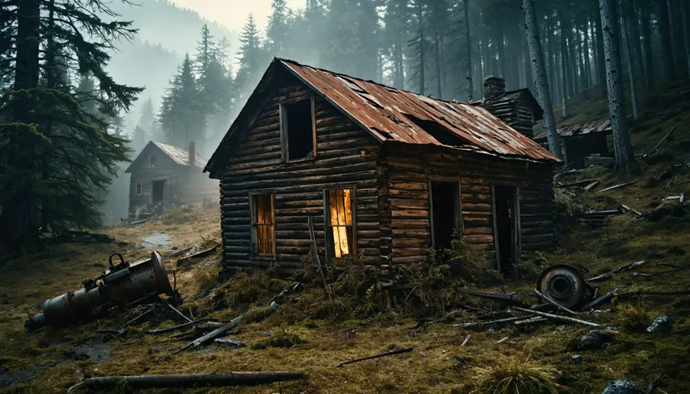
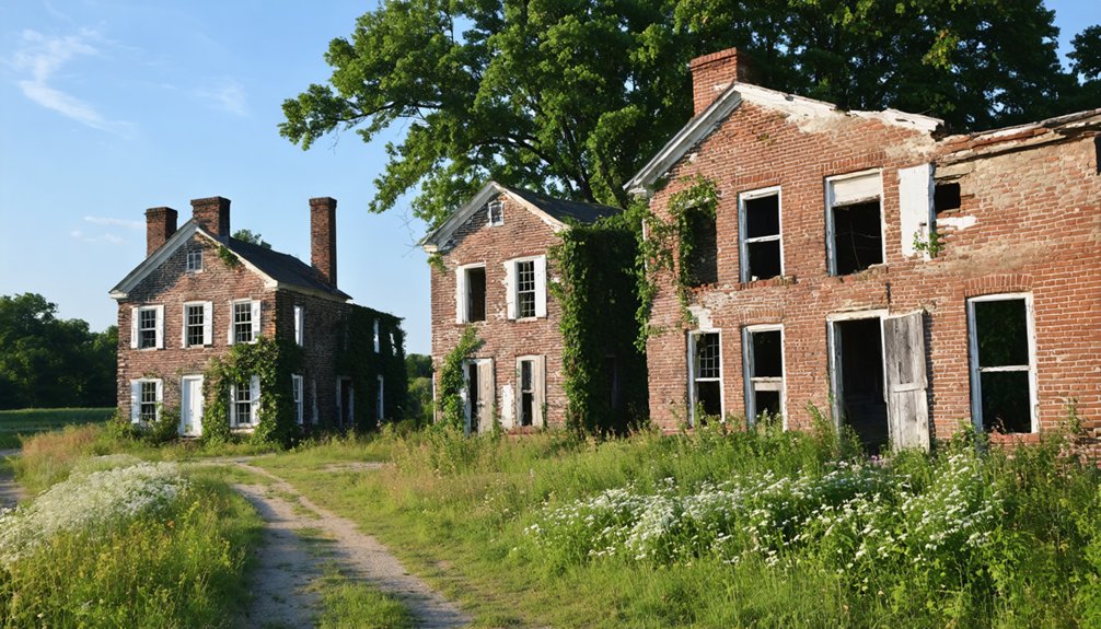
Daniels Mill Town in the Baltimore Area
Hidden within a sheltered wooded valley where the Patapsco River bends between Baltimore and Howard counties, the abandoned textile community of Daniels stands as a haunting memorial to America’s vanished mill town era.
Daniels textile mill—a ghostly testament to forgotten American industry, frozen in time along the Patapsco River’s wooded bend.
You’ll discover remnants of a once-thriving settlement where 279 residents were mysteriously ordered to evacuate in 1968 after 158 years of continuous operation.
Historic preservation efforts placed the mill on the National Register in 1973, though Tropical Storm Agnes destroyed most abandoned buildings the following year.
Today, you can hike the scenic 3-mile trail past crumbling churches, stone foundations, and the iconic dam.
The overgrown cemetery behind the church contains over 57 graves, with headstones dating back to 1919, though many markers have been damaged or obscured by vegetation over the decades.
Two weathered churches, a smokestack, and scattered ruins mark where families once lived, worked, and built community—reminders that industrial progress eventually leaves everyone behind.
The settlement’s name appears in multiple place references across different regions, reflecting the common practice of naming mill towns after their founding families.
Fort Armistead’s Graffiti-Covered Ruins
You’ll find Fort Armistead’s crumbling concrete walls transformed into an unexpected canvas, where vibrant graffiti now decorates what was once a formidable late-1800s coastal defense installation guarding Baltimore’s harbor.
The fort’s maze of tunnels, hidden rooms, and gun emplacements creates an eerie playground for urban explorers and photographers drawn to its haunting atmosphere. Built between 1897 and 1901, the fort was named after the commander of Fort McHenry from the War of 1812.
The fortifications worked alongside Forts Howard, Smallwood, and Carroll to create overlapping artillery ranges that deterred naval threats to the city. Plan your visit during summer daylight hours when Fort Armistead Park opens for fishing and riverside access, but watch your step—broken glass, debris, and caved-in passages make this historical site as hazardous as it’s mesmerizing.
Military Base History Overview
Between 1897 and 1901, the U.S. Army constructed Fort Armistead at Hawkins Point as part of the Endicott Program‘s ambitious coastal defense network protecting Baltimore’s Inner Harbor. This military architecture masterpiece featured multiple batteries armed with disappearing 12-inch guns, 4.72-inch Armstrong artillery, and 3-inch rapid-fire weapons.
Named after Fort McHenry’s War of 1812 commander, it formed a four-fort system with overlapping fields of fire. The installation included a mine casemate controlling naval minefields guarding the harbor entrance.
When World War I erupted in 1917, the Army stripped the batteries bare, shipping weapons overseas. The fort closed permanently in 1920, was declared surplus in 1923, and transferred to Baltimore’s parks department in 1928. The U.S. Navy temporarily reoccupied the site during WWII for ammunition storage. After the war, the site transformed into a park featuring fishing and walking trails.
Today, you’ll discover atmospheric concrete bunkers, shadowy tunnels, and battery ruins reclaimed by nature and urban artists.
Urban Art and Exploration
Where else can you find a century-old military fortress transformed into an open-air canvas for street artists? Fort Armistead’s concrete gun batteries now showcase vibrant graffiti artistry across their 125-year-old walls, creating an unexpected fusion of history and modern expression.
You’ll discover exuberant spray paint covering tunnels and hidden rooms, where sparkling colors pop against weathered concrete.
Urban exploration here feels genuinely daring, despite the park setting. Navigate debris-strewn staircases, peer into mine casemates, and examine round steel artillery mounts while surrounded by nature’s encroachment. This once state-of-the-art coastal defense installation hosted radar-guided artillery that was never fired in combat. The fort was constructed during the Endicott era as part of Baltimore’s comprehensive coastal defense system.
The graffiti-covered ruins overlooking the Patapsco River offer striking photography opportunities where street art contrasts beautifully with crumbling infrastructure.
While overgrown and neglected, these accessible ruins let you experience urban decay’s eerie appeal without the danger of completely abandoned sites.
Summer Park Access Tips
Planning your visit to Fort Armistead’s graffiti-covered ruins requires strategic timing and preparation to maximize both safety and enjoyment. You’ll find parking within the park grounds, with daylight access offering the clearest views of these abandoned coastal batteries.
Summer safety demands vigilance—broken glass and debris litter the tunnels and hidden rooms, making sturdy boots essential. Leave young children and dogs at home due to hazardous contaminants scattered throughout.
The park amenities remain minimal, as authorities maintain this historical site with little intervention. You’re free to explore the unmoored structures, though crumbling infrastructure demands careful navigation. Bring water and sun protection for Maryland’s humid summers.
Visit during morning hours for cooler temperatures and ideal photography lighting across the Patapsco River views.
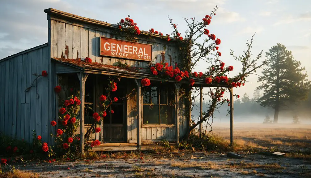
Port Tobacco Village Historic Site
Once Maryland’s second-largest port after Annapolis, Port Tobacco thrived as an international trading hub where tobacco and corn left its wharves for distant shores. Today, you’ll find preserved colonial buildings like the 1766 Stagg Hall and a reconstructed courthouse standing silent where merchants once haggled and enslaved Africans labored.
Visit between March and December to walk summer trails through this remarkably intact 17th-century settlement, where river siltation transformed a bustling seaport into one of the state’s most archaeologically significant ghost towns.
Maryland’s Second-Largest Town
Though today it counts merely 13 residents, Port Tobacco Village once commanded the Chesapeake Bay’s maritime trade as Maryland’s second-largest port.
By the late 1600s, merchant ships transported tobacco and corn to international markets while returning with Caribbean sugar, European silks, and fine china.
You’ll discover this remarkable transformation through:
- Historical architecture at three preserved structures: Stagg Hall, Washington Burch House, and the Port Tobacco Courthouse
- Cultural museums revealing the town’s role as Charles County’s governmental seat from 1658 to 1895
- Warehouse Point remnants where wooden barrels once rolled toward waiting vessels
The river’s siltation and railroad expansion eventually strangled commerce, transforming this bustling colonial hub into Maryland’s smallest incorporated town—a testament to nature’s power over human ambition.
Summer Trail Exploration
Today’s Port Tobacco Village offers three miles of walking trails that wind through the same landscape where merchant ships once anchored.
You’ll find wide, well-marked paths perfect for nature photography, with observation platforms positioned for capturing eagles and wetland wildlife.
The flat terrain lets you explore freely without technical hiking gear, though trail safety basics still apply near the narrower riverside sections.
Summer’s your ideal season here—shaded woods provide relief from heat while you wander between the historic village site and Tom Roland Natural Resource Area.
Informative signage identifies local species without overwhelming you.
Launch your kayak at the river pull-up spot, or simply walk the peaceful trails where Charles County‘s once-thriving port has returned to wilderness.
You’ll discover history on your terms.
Four Locks on the Chesapeake and Ohio Canal
This once-thriving community supported over 30 buildings:
- A general store selling penny candy, hams, and kerosene for just $36 yearly lease
- An innovative 1879 telephone system connecting 46 phones across Maryland
- A strategic dry dock where boats underwent repairs on raised beams
Today, you’re free to explore the National Park Service-managed remnants southwest of Clear Springs, where crumbling locks stand proof of America’s canal era (1828-1924) and the resilient families who built lives along these waterways.
Sinepuxent Coastal Ghost Town
Long before Assateague Island became synonymous with wild ponies, a bustling colonial settlement commanded the shores of Sinepuxent Bay in Worcester County.
Centuries before wild ponies roamed free, colonial traders built a thriving settlement along Sinepuxent Bay’s strategic shores.
You’ll discover Sinepuxent’s fascinating story began with the Assateague Indians’ hunting camps 10,000 years ago, evolving into a thriving 1700s trading hub where Captain Charles Rackliffe exchanged plantation goods for British silks through the convenient Sinepuxent Inlet.
The 1818 hurricane erased this prosperity overnight, destroying the village and sealing the inlet permanently.
Today, you can explore the restored Rackliffe House at Assateague State Park, where archaeological preservation efforts uncovered pre-1650 Native American pottery and colonial artifacts.
However, coastal erosion and development threaten remaining sites. Visit this haunting landscape where three-quarters of the property still holds untold archaeological secrets beneath your feet.
Harmony Grove’s Lost Milling Community
While coastal forces destroyed Sinepuxent, inland Maryland witnessed a different pattern of abandonment as industrialization’s promise gave way to obsolescence.
You’ll find Harmony Grove in Frederick County, where Worman’s Mill once powered a thriving 1820s settlement. The Frederick & Pennsylvania Railroad brought prosperity in 1872, but decline arrived swiftly when rails fell silent.
Industrial remnants tell the story:
- Spring Bank Inn stands in disrepair, echoing voices of mill workers and travelers
- An 1878 church remains defiant against time’s erosion
- Train track foundations mark where commerce once flowed
Route 15’s 1970s expansion severed the town’s heart, demolishing abandoned buildings including the post office and freight warehouse.
Today you’ll discover mostly foundations and memories, documented as F-3-108 by Maryland Historical Trust—freedom to explore industrial history’s ghostly footprint.
Wagner’s Point Industrial Evacuation Site
At Baltimore’s southeastern edge, where the Patapsco River meets industrial sprawl, Wagner’s Point stands as Maryland’s only ghost town born from toxic necessity rather than economic decline.
You’ll find nothing but vacant industrial land where 270 residents once endured a century of explosions, fires, and relentless industrial pollution.
Ten chemical plants and oil refineries surrounded this six-block neighborhood, creating one of America’s most toxic places by the late 1990s.
Cancer rates soared beyond national averages as families breathed contaminated air daily.
The 1998 community displacement came after Senator Mikulski secured federal buyout funds, ending residents’ battles against an untenable environment.
Today’s coordinates 39°14′4″N 76°34′8″W mark where homes stood—now just the Patapsco Waste Water Treatment Plant remains.
Weverton’s Relocated Settlement
Maryland’s ghost towns weren’t all consumed by industrial poison—some simply faded when their founder’s ambitions couldn’t overcome geography’s harsh realities. Caspar Wever platted Weverton in the 1830s, banking on dual access to the C&O Canal and B&O Railroad.
Not every ghost town died from toxins—some were simply drowned by floods and washed away by geography’s indifference.
He incorporated manufacturing companies, built water-powered mills, and operated a file factory by the mid-1840s.
Nature proved unforgiving. Floods hammered the settlement repeatedly, washing away Wever’s industrial dreams before the Civil War arrived.
What you’ll find today:
- Abandoned factories reduced to stone foundations along the towpath
- Forgotten settlements accessible only through canal corridor hikes
- Remnants near Lock 31 that most travelers pass without recognition
The valley’s German and Scotch-Irish pioneers have long departed, leaving Weverton as another riverside ghost you can explore on foot.
Frequently Asked Questions
Are Guided Tours Available at Maryland Ghost Towns During Summer Months?
You’ll totally Netflix-binge Maryland’s haunted history through guided navigation across Eastern Shore, Baltimore, and Annapolis ghost tours. Historical preservation meets spine-tingling storytelling as you explore murder sites, haunted streets, and paranormal hotspots throughout summer’s darkest nights.
What Safety Precautions Should Visitors Take When Exploring Abandoned Sites?
You’ll need proper safety gear including sturdy boots, gloves, and flashlights while practicing constant hazard identification for unstable floors, rusty metal, and wildlife. Never explore alone, respect private property, and always inform someone of your location beforehand.
Can I Legally Enter and Photograph All Maryland Ghost Town Locations?
Legal access varies by location—you can’t enter all Maryland ghost towns freely. State parks like Patapsco Valley welcome visitors, but private properties and military sites require permission. Photography permits depend on ownership and commercial use intentions.
Exploring ghost towns in western Maryland can be an exciting adventure for those interested in history and abandoned places. However, it’s essential to respect the boundaries of private landowners while seeking out these hidden gems. Many enthusiasts share their experiences online, providing tips about where to find the most accessible locations and the best times to visit.
Some of the most intriguing abandoned sites in western Maryland are remnants of old mining towns, where history comes alive through dilapidated structures and overgrown landscapes. Adventurers can also discover the echoes of the past in forgotten railroads and crumbling factories, each telling a unique story of a bygone era. Exploring these locations not only satisfies curiosity but also connects visitors to the rich tapestry of Maryland’s history.
Which Ghost Towns Are Most Family-Friendly for Summer Visits With Children?
Daniels Ghost Town and Four Locks offer the best family-friendly exploration with safe trails, historic preservation sites, and accessible ruins. You’ll discover local legends while kids enjoy riverside hikes and canal paths—perfect adventures without restrictive barriers.
Are Camping Facilities Available Near Maryland’s Ghost Town Locations?
Yes, you’ll find excellent camping at Lapidum Ghost Town and Point Lookout’s Civil War ruins, where historical preservation meets adventure. These sites blend local legends with modern amenities—showers, wooded sites, and hiking trails—letting you explore freely while staying comfortable overnight.
References
- https://en.wikipedia.org/wiki/List_of_ghost_towns_in_Maryland
- https://kids.kiddle.co/List_of_ghost_towns_in_Maryland
- https://chesapeake-inspired.com/top-haunted-towns-in-maryland/
- https://www.marylandhauntedhouses.com/real-haunts/
- https://www.youtube.com/watch?v=Obb_sDHYm9A
- https://www.atlasobscura.com/things-to-do/maryland/abandoned
- https://www.geotab.com/ghost-towns/
- https://www.mdmountainside.com/blog/post/haunted-history-places-to-visit-for-a-ghostly-good-time/
- https://www.tripadvisor.com/Attraction_Review-g41363-d103280-Reviews-Historic_St_Mary_s_City-Saint_Mary_s_City_Maryland.html
- https://www.historyhit.com/locations/historic-st-marys-city/