You’ll find Nebraska’s best summer ghost towns scattered across windswept prairies and river bluffs, each telling unique frontier stories. Visit Amboy’s depot ruins during wildflower season for stunning sunset photography, explore Rock Bluff’s 1870 schoolhouse along shaded trails, or discover Antioch’s haunting potash plant remains amid golden prairie grass. St. Deroin’s relocated buildings sit within Indian Cave State Park’s 22-mile trail network, while Brocksburg’s outlaw legends unfold along scenic Highway 12. Each site below reveals more about Nebraska’s vanished communities and how to experience them.
Key Takeaways
- Amboy offers depot ruins and prairie wildflowers best viewed during summer blooming season with ideal sunset photography opportunities.
- Antioch features dramatic potash plant ruins perfect for golden hour photography amid summer prairie wildflowers and vast open landscapes.
- Indian Cave State Park provides 22 miles of trails, living history demonstrations, and year-round access including summer camping options.
- Brocksberg along the Outlaw Trail Scenic Byway combines weathered foundations, Missouri River bluff views, and wild west outlaw legends.
- Rock Bluff features Nebraska’s oldest schoolhouse with shaded summer trails along the bluff and historic frontier educational site access.
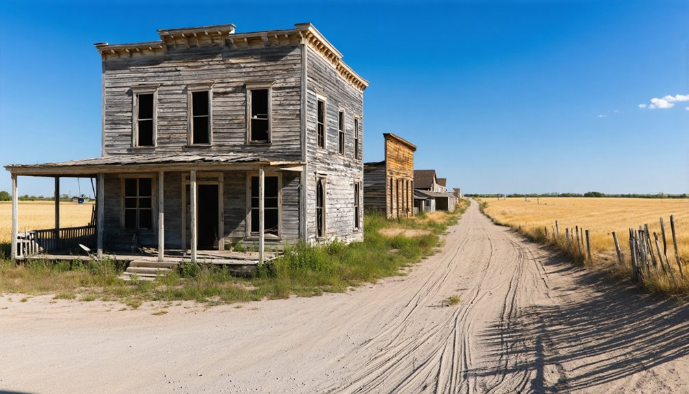
Amboy: Panoramic Prairie Views and Settlement Remnants
The gravel road to Amboy cuts through waist-high prairie grass four miles east of Red Cloud, where a weathered informational sign barely hints at the bustling railroad town that once stood here.
You’ll need to venture down back roads to find the settlement remains—a depot, warehouse, barn, and that spectacular mill architecture rising against endless sky.
Founded in 1876, Amboy thrived until the 1940s when the railroad pulled out.
The town survived Indian raids and two relocations before the rails finally determined its fate.
Originally called Webster Center, the settlement was renamed Amboy in 1879, likely after the Illinois town of the same name.
Time your visit during wildflower blooming season when prairie colors explode across the landscape.
Sunset photography here captures something raw and untamed—just you, the remnants, and that panoramic Nebraska sky stretching forever.
Today, the population around 100 maintains a quiet existence among these historic structures.
Rock Bluff: Historic Schools and Shaded Bluff Trails
Perched on the Missouri River’s western banks three miles east of Murray, Rock Bluff tells a different ghost town story—one where educated ambition collided with railroad reality.
Rock Bluff’s dreams of becoming an educational hub vanished when the railroad chose a different route, leaving ambition stranded on the riverbank.
You’ll discover the 1870 Rock Bluff School, Nebraska’s oldest surviving schoolhouse and Cass County’s first higher education institution. This historical architecture piece, originally the two-story Naomi Institute, stands as proof to frontier aspirations that couldn’t outlast steel rails.
Community legends whisper of the town’s 1866 vote-counting scandal that nearly derailed Nebraska’s statehood.
Today, you can explore shaded bluff trails where steamboat captains once guided vessels to landing points. The abandoned race track and collapsed coal mine entrances reward curious wanderers. At its peak around 1877, the bustling community supported nearly 200 residents alongside three stores, two blacksmith shops, and thriving social lodges. The Missouri River’s role as a transportation and migration route dates back to early exploration efforts by Steven H. Long in 1820 and John C. Fremont in 1842, long before settlements like Rock Bluff emerged along its banks.
St. Deroin: Missouri River Trading Post at Indian Cave State Park
You’ll find St. Deroin’s story written in the Missouri River itself—the same waters that once carried ferry passengers between Nebraska and Iowa for over thirty years now flow through the ghost town’s original streets.
Joseph Deroin’s 1840 trading post served the Otoe people and mixed-heritage families on the Nemaha Half-Breed Reservation, positioning the settlement as a hopeful rival to St. Joseph and St. Louis downriver. First townsite in Nemaha County, St. Deroin was formally established in 1853 and later resurveyed in 1865 after serving a population of 232 residents.
Today, you can visit the relocated brick schoolhouse at Indian Cave State Park, one of the few structures salvaged before the river erased this trading hub from the landscape in the early 1900s.
Ferry Operations and Decline
Starting in 1854, ferry operations transformed St. Deroin into a crucial river crossing between Iowa and Nebraska. You’ll discover how this essential link carried settlers, traders, and dreams across the Missouri River for over three decades. The ferry powered the town’s identity alongside its post office and schoolhouse, connecting pioneers to downriver markets in St. Louis and enabling westward expansion.
Transportation history took a dramatic turn when the unpredictable Missouri shifted course. River erosion rapidly devoured the town site, swallowing buildings and access routes by 1912.
The schoolhouse fled to higher ground that same year, while the post office shuttered in 1910. Nature reclaimed what settlers built, ending ferry service and transforming this once-bustling crossing into the ghost town you’ll explore today.
Trading Post History
Long before the ferry landings and steamboat wharfs defined St. Deroin, Native American trade networks thrived at this Missouri River junction.
You’re standing where Joseph Deroin, a Métis trader born in 1819, recognized opportunity in 1840. His father had worked these waters for decades through the American Fur Company, understanding fur trade dynamics that made fortunes.
Joseph established his post where the Platte met the Missouri, serving 232 residents on the Nemaha Half-Breed Reservation.
Fluent in multiple languages, he bridged cultures that older posts had served since Lewis and Clark’s 1804 expedition.
The Otoe village here wasn’t just backdrop—it was commerce, community, and crossroads.
State Park Access Today
While Joseph Deroin’s original trading post vanished beneath shifting river currents generations ago, Indian Cave State Park preserves his legacy across 3,052 acres of Missouri River bottomland.
You’ll find the park 1.5 hours south of Omaha, accessible 24/7 year-round at 65296 720 Rd, Shubert.
What awaits you:
- 22 miles of hiking trails winding through scenic overlooks where local wildlife roams freely
- Reconstructed St. Deroin village featuring the original schoolhouse and general store from the 1854 settlement
- Concrete boat ramp launching you directly onto the Missouri River’s wild currents
Park renovation has enhanced facilities while maintaining authentic frontier character.
You’ll discover craft demonstrations, equestrian trails, and primitive camping options.
The park hosts living history weekends where interpreters demonstrate traditional frontier crafts and skills.
The large sandstone cave that gives the park its name offers a glimpse into the area’s geological history.
The interactive river guide helps you navigate public access points independently—no guided tours required.
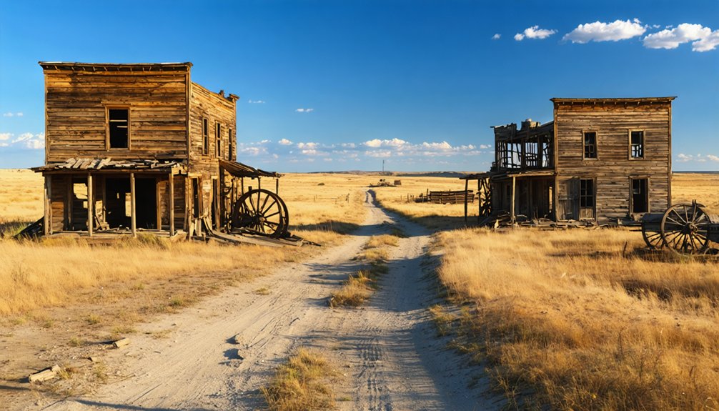
Antioch: Remote Homesteading Ruins and Photography Opportunities
The prairie wind whips across Antioch’s scattered concrete foundations and crumbling potash plant walls, creating an otherworldly landscape. This is a place where industrial ambition met the Sandhills.
You’ll find the best shots during golden hour when low-angle sunlight carves deep shadows into the weathered structures. At the same time, it illuminates the endless grass stretching toward the horizon.
Bring a wide-angle lens to capture the isolation—these sparse ruins gain their haunting power from the vast emptiness surrounding them, not ornate architectural details. Unlike the ancient Antioch that once housed over 500,000 residents, this Nebraska ghost town stands as a testament to abandonment rather than imperial grandeur.
Located 15 miles east of Alliance on Nebraska Highway 2, the site is easily accessible for photographers seeking authentic prairie ghost town imagery.
Sparse Foundations and Structures
Crumbling concrete foundations rise from the prairie grass like scattered tombstones, marking where Antioch’s five massive potash reduction plants once thrummed with wartime industry. These industrial remnants tell a story of rapid boom and sudden abandonment that’ll fascinate anyone drawn to America’s forgotten places.
When you explore these ruins, you’ll discover heritage preservation through tangible history:
- Oddly-shaped concrete slabs from the American, Nebraska, Alliance, National, and Western companies stretch across the landscape.
- Partial walls and pumping station foundations provide glimpses into 1918’s sophisticated brine extraction operations.
- Scattered debris fields reveal where 5,000 residents once lived in company housing.
The site earned National Register listing in 1979, protecting these haunting structures. Two University of Nebraska graduates pioneered the extraction method that transformed this remote location into a vital wartime production center. Fewer than 25 residents remain, making your exploration feel authentically remote and undisturbed.
Open Prairie Photography Tips
Golden hour transforms Antioch’s desolate concrete slabs into dramatic subjects you won’t find anywhere else in Nebraska.
Position yourself between the ruins and setting sun to capture long shadows stretching across the Sandhills. The contrast between geometric concrete and organic sand dunes creates compositions that’ll stop viewers mid-scroll.
Spring through early summer brings prairie wildflowers that soften the industrial decay—frame crumbling walls against purple coneflowers and yellow sunflowers.
Wide-angle lenses emphasize the expansive isolation, while telephoto shots compress the alkali lakes against distant ruins.
Pack water and sun protection for this exposed location. Contact local residents beforehand to photograph beyond the fences.
The historical marker provides context shots, but the real magic happens when you’re shooting through rusted gates at industrial archaeology meeting raw prairie.
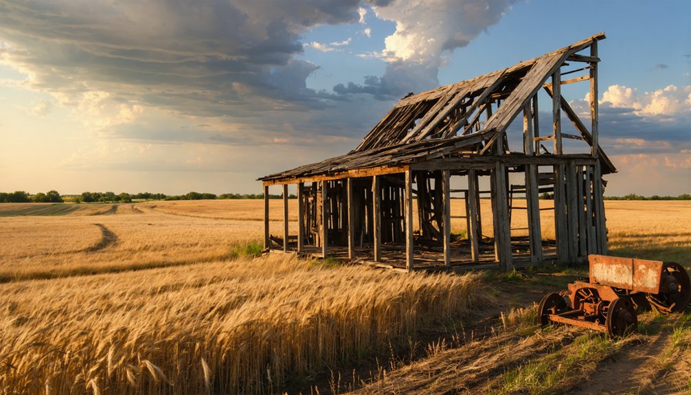
Brocksburg: Scenic Byway Discovery Along the Outlaw Trail
Nestled amid the rolling green hills of northern Nebraska, Brocksberg sits along Highway 12—the legendary Outlaw Trail Scenic Byway that once sheltered Jesse James and horse thieves fleeing through these wind-swept canyons.
Where Nebraska’s outlaw legends still echo through wind-carved canyons and forgotten trails of the Wild West.
Founded by Henry Brockman in the 1890s, this ghost town whispers local legends of Kid Wade and Doc Middleton riding these same trails.
You’ll discover why outlaws chose this territory: deep ravines, dense tree cover, and endless escape routes through the Niobrara River valley.
What You’ll Experience:
- Historic architecture—reduced to weathered foundations where Brocksberg’s 1899 post office once stood
- Panoramic views across emerald hills stretching toward the Missouri River bluffs
- Complete solitude on this 238-mile byway connecting forgotten settlements
Pack your camera and claim a full summer day—this seven-hour journey demands no fees, only curiosity.
Dobytown: Oregon Trail Heritage Near Fort Kearny
From the lawless hideouts of Brocksburg’s outlaw country, travel southeast to where civilization attempted its first foothold along Nebraska’s most famous trail. You’ll discover Dobytown at 800-814 State Highway 50A, where twelve earthen buildings once serviced westward-bound pioneers from 1859 to 1871.
This wasn’t your typical settlement—it thrived on everything Fort Kearny wouldn’t allow: gambling, whiskey General Sherman called “tanglefoot,” and women of ill repute.
Local folklore celebrates Dobytown as the frontier’s wildest supply hub, where thousands of travelers resupplied between Missouri and California.
You’ll find preserved artifacts at this National Register site, though the town vanished when railroads rendered wagon trains obsolete.
Walk where Pony Express riders changed horses and soldiers sought entertainment beyond military regulations.
Frequently Asked Questions
What Supplies Should I Bring When Visiting Remote Nebraska Ghost Towns?
You’ll need water, sturdy boots, a first aid kit, and camera gear for historical preservation photography. Pack sunscreen, insect repellent, and snacks—there’s no services out there. Bring your sense of adventure and respect for these forgotten places.
Are These Ghost Towns Safe for Children to Explore During Summer?
You’ll find endless adventure awaiting! Most Nebraska ghost towns are safe for kids with supervision. Historical preservation keeps structures stable, while wildlife encounters—think deer, not dangers—add excitement. Bring water, sun protection, and stick together on those remote prairie paths.
Exploring ghost towns in Nebraska can provide a unique glimpse into the past, showcasing the stories of those who once inhabited these now-deserted areas. As you wander through the remnants of old buildings, take the time to read the informative plaques that detail the history and significance of each town. Keep your eyes peeled for hidden treasures like vintage artifacts that may have been left behind, adding an element of surprise to your adventure.
Can I Camp Overnight Near Any of These Abandoned Settlement Sites?
You can’t camp directly at abandoned sites, but you’ll find designated campgrounds nearby. Scout Forest Service land for dispersed camping within 14 days, perfect for capturing sunrise photography and respecting historical preservation while maintaining your independence.
Do I Need a Four-Wheel-Drive Vehicle to Reach These Locations?
You won’t need off-road vehicles for Nebraska’s ghost town adventures—most sit along highways or maintained county roads. Road conditions stay passable year-round on gravel spurs, letting you chase history’s whispers without specialized gear cramping your freedom.
Are There Guided Tours Available for Nebraska Ghost Town Visits?
Yes, you’ll find guided tours exploring Nebraska’s ghost towns through local legends and historical preservation efforts. Companies like US Ghost Adventures and Midwest Paranormal History Tours offer interactive experiences that’ll immerse you in authentic frontier stories and eerie abandoned settlements.
As you delve into exploring the history of nebraska ghost towns, you’ll uncover tales of resilient pioneers and the mysteries that shroud these once-thriving communities. Each stop reveals a piece of the past, where crumbling buildings stand as silent witnesses to the dreams and hardships of those who came before. Such an exploration not only highlights the architectural remnants but also the rich narratives waiting to be discovered in the great plains.
References
- https://www.ghosttowns.com/states/ne/ne.html
- https://history.nebraska.gov/wp-content/uploads/2017/12/doc_publications_NH1937GhostTowns.pdf
- https://www.youtube.com/watch?v=l3s2qhSxis8
- https://kids.kiddle.co/List_of_ghost_towns_in_Nebraska
- https://www.onlyinyourstate.com/trip-ideas/nebraska/ne-ghost-towns-road-trip
- https://freepages.rootsweb.com/~gtusa/history/usa/ne.htm
- https://en.wikipedia.org/wiki/List_of_ghost_towns_in_Nebraska
- https://visitnebraska.com/trip-idea/explore-7-authentic-ghost-towns-nebraska
- https://history.nebraska.gov/finding-nebraskas-ghost-towns/
- https://www.youtube.com/watch?v=tJWaL6_ovK8


