You’ll find Oklahoma’s best summer ghost towns along Route 66 at Texola, where the 1910 Territorial Jail stands guard over abandoned storefronts, and at Earlsboro, where a four-story hotel crumbles on Main Street amid whispers of Pretty Boy Floyd’s legacy. Visit Hochatown’s submerged ruins beneath Broken Bow Lake, explore McCurtain’s miners cemetery, or photograph Blackburn’s whiskey-town relics. Early morning light transforms these sites into photographer’s gold, while cooler temperatures make exploration comfortable before midday heat arrives—and there’s essential gear you’ll need before setting out.
Key Takeaways
- Hochatown at Broken Bow Lake offers summer boating and camping along 180 miles of shoreline with underwater ghost town exploration.
- Earlsboro features abandoned 1930s buildings and Oklahoma’s most haunted reputation, best explored at dusk during cooler summer evenings.
- Texola on Route 66 showcases historic buildings like Magnolia Service Station and the 1910 Territorial Jail amid fading roadside relics.
- Visit early morning or late afternoon to avoid extreme midday heat exceeding 95°F at most Oklahoma ghost town sites.
- Bring sturdy boots, offline maps, respirator masks, and photography gear to safely explore and document deteriorating summer structures.
Hochatown: Underwater History Beneath Broken Bow Lake
Deep beneath the emerald waters of Broken Bow Lake lies a ghost town with secrets older than Oklahoma itself. You’ll find Hochatown’s submerged streets where moonshine once flowed freely and Choctaw families built their lives. The Army Corps flooded this valley in 1968, swallowing homes, the general store, and schoolhouse beneath 14,000 acres of water.
Today, you can explore what remains through SCUBA diving expeditions into this underwater time capsule. While you won’t discover Victorian architecture or underground tunnels here—this was a humble lumber camp turned farming community—you’ll encounter authentic frontier history. Before the timber ran out, the settlement served loggers with a commissary and bunkhouse that kept the camp running. The Union Church and graves were relocated to higher ground before the flooding claimed the valley.
The relocated Hochatown thrives above on Highway 259, where descendants still guard their ancestors’ moonshine recipes. Visit during summer when the lake’s 180 miles of shoreline offer freedom through boating and camping.
McCurtain (Panther): A Mining Town That Refused to Die
How does a town survive after tragedy kills 73 men in a single morning? You’ll find the answer in McCurtain, where mining history runs deeper than the coal seams that once made it prosperous.
Where mining history cuts deeper than the coal seams that built it, McCurtain reveals how tragedy reshapes survival.
Originally called Panther, this 1889 settlement housed 400 company homes before the 1912 Mine Number Two explosion shattered everything. The Sans Bois Mining Company, which shaped the town’s entire economy, fell under Henry Clay Frick’s control in 1901.
Today, you’re free to explore remnants most tourists miss. Visit the memorial at the disaster site, where ghost stories whisper through abandoned shafts.
Walk among 73 graves in Miners Cemetery—each marker tells a story of men who chased opportunity into darkness.
With just 356 residents now, McCurtain’s not completely dead. It’s something rarer: a town that absorbed tragedy and refused to vanish. The town was renamed in 1902 after Greenwood McCurtain, the Choctaw Nation’s last principal chief, marking a new chapter in its survival story.
Pack water, respect the memorials, and discover what survives when everything else collapses.
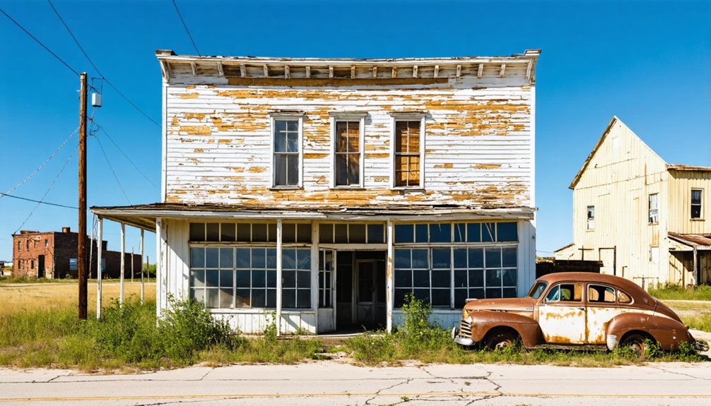
Texola: Route 66’s Fading Roadside Relic
Where Oklahoma bleeds into Texas, Texola clings to Route 66 like a sun-faded photograph refusing to let go. You’ll find the Magnolia Service Station‘s crumbling walls at the highway split—local architecture frozen in time, awaiting historic preservation that may never come.
The Tumbleweed Grill serves all-day breakfast in a restored 1930s building, the oldest working café on the Mother Road.
Step inside the one-room Territorial Jail from 1910, where outlaw legends echo through iron bars.
This town peaked at 581 souls in 1930 before the Dust Bowl and Interstate 40 bled it dry. Steinbeck immortalized this stretch in The Grapes of Wrath, capturing the desperation of migrant farmers fleeing westward during the Depression.
Now abandoned beer joints and derelict storefronts line Grand Avenue, offering you something rare: authentic decay without tourist polish. The ruins of the Friendly Cafe stand as ghostly reminders of Route 66’s heyday, their skeletal frames still visible to photographers drawn to this haunting landscape.
Exit I-40 and embrace the melancholy beauty of forgotten America.
Blackburn: The Whiskey Town Time Forgot
Across the Arkansas River from what was once dry Indian Territory, Blackburn sprang to life in 1893 as Oklahoma’s answer to Kentucky bourbon country—a whiskey oasis where thirsty patrons forded the water for legal liquor. This rowdy frontier town thrived on prohibition‘s border until statehood dried up its primary business in 1907. Unlike neighboring settlements transformed by petroleum fortunes, Blackburn remained untouched by the oil boom, preserving its original character when no railroad or highway ever reached the isolated community.
Today’s Blackburn offers authentic history preservation and cultural significance through remnants of its spirited past:
- Blackburn Methodist Church (National Register of Historic Places) stands as architectural testimony to moral redemption.
- Original townsite reveals foundations where two banks and saloons once competed.
- Arkansas River crossing where desperate drinkers once traversed for forbidden spirits.
Twenty-five families maintain this bedroom community, where you’ll discover freedom from commercialized tourism and genuine connection to Oklahoma’s untamed territorial days. The town’s population has dwindled to around 70 residents, a fraction of its raucous heyday when whiskey flowed freely across the river.
Earlsboro: Oklahoma’s Most Haunted Ghost Town
You’ll find Earlsboro’s story written in its unpainted houses—some haven’t seen a brush since the 1930s oil bust that followed the whiskey boom.
Stand on what remains of Main Street, once lined with 41 gas stations and a four-story hotel that cost $100,000, and you’ll feel the ghosts of Pretty Boy Floyd and James Earls, the Black barber and whiskey dealer who gave this wild town its name.
Plan your summer visit for early morning when the heat hasn’t yet risen from the abandoned lots where speculators once paid $10,000 for 25 feet of dirt. Before the oil discovery on March 1, 1926, this was already a wild whiskey town where 90% of merchants profited from liquor sales to customers streaming in from nearby Indian Territory. The town sits just 2-3 miles west of Shawnee, accessible by 2WD roads that wind through what’s become primarily agricultural and cattle country again.
Historic Boom and Decline
Deep in the heart of Pottawatomie County, Earlsboro’s story reads like a fever dream of American frontier capitalism. You’ll discover a town that exploded from 387 souls to nearly 10,000 within months when the Earlsboro Sand gushed black gold in 1926.
Walk these streets where economic decline tells its tale through unpainted homes frozen since the 1930s. The boom left behind:
- $10,000 lots where speculators pitched tents at $25 monthly
- 41 gas stations serving a population now reduced to 640
- Demolished $100,000 hotel marking bankruptcy’s aftermath
Historical preservation here means embracing decay as a testament. You’ll find a place whiskey built and oil broke—not quite ghost town, but unrecognizable from glory days when Pretty Boy Floyd walked these five-block stretches between bank jobs.
Paranormal Activity and Legends
Beyond the crumbling economics lies something darker—Earlsboro wears Oklahoma’s crown as the state’s most haunted town. You’ll find the abandoned school building perfectly preserved, books and globes untouched, as if students vanished mid-lesson.
The haunted folklore runs deep here—locals claim you can’t stay fearless after spending enough time among these 640 remaining souls.
One resident witnessed spectral sightings firsthand: a little girl’s apparition outside the high school, appearing within three minutes before lighting something and disappearing. Yet you’ll encounter skeptics too—one six-year resident knew nothing of these legends despite loving the town.
Visit the crumbling structures at dusk when the veil thins. The liquor-soaked saloon era and oil boom decline created perfect conditions for restless spirits seeking freedom beyond the grave.
Summer Exploration Tips
When planning your summer visit to Earlsboro, timing your arrival for early morning or late afternoon spares you from Oklahoma’s brutal midday heat—temperatures regularly crack 95°F across these exposed plains.
Located seven miles east of Tecumseh via Pottawatomie County roads, this settlement of roughly 600 residents offers authentic exploration without tourist crowds.
Essential exploration priorities:
- Historical architecture: Seek the unpainted homes frozen since the 1930s oil bust and remnants of five-block Main Street where 41 gas stations once thrived.
- Local legends: Trace connections to Pretty Boy Floyd’s bank robbery and oil field roustabout camps that housed thousands during the 1926 boom.
- Safety protocols: Respect private property boundaries, carry water, and photograph structures from public roads—this isn’t curated heritage tourism.
You’ll discover genuine Oklahoma grit here.
Picher: The Town That Completely Vanished
You’ll find Picher’s eerie silence most unsettling on summer mornings when sunlight catches the towering chat piles—gray mountains of mining waste that loom over empty streets where 14,000 people once lived.
The 2008 EF-4 tornado didn’t just destroy buildings; it delivered the final blow to a community already poisoned by lead contamination and collapsing mine shafts beneath every foundation.
Unlike other Oklahoma ghost towns that slowly faded, Picher vanished completely through government buyout, making it the state’s only true modern ghost town where even lingering is dangerous.
Tornado’s Devastating 2008 Impact
On May 10, 2008, an EF4 tornado carved a path of destruction that would seal Picher’s fate forever. You’ll discover how nature delivered the final blow to this already-dying town, with winds reaching 175 mph that swept through at 5:40 pm.
The devastation tells a stark story of urban decay meeting nature’s fury:
- 200 homes destroyed – 114 completely leveled to their foundations, leaving only scattered photographs and children’s toys
- 6 lives lost in Picher alone – part of 21 total fatalities across the tornado’s 75-mile path
- Toxic chat piles spread – lead-contaminated mining waste scattered throughout the debris field
This catastrophe ended any hope for historical preservation. Governor Brad Henry toured the wreckage, and Picher’s disincorporation became inevitable.
Today, you’ll find only foundations and pavement where neighborhoods once stood.
Mining Legacy and Abandonment
The discovery of lead and zinc ore in 1913 transformed Harry Crawfish’s Quapaw allotment into what would become America’s most productive—and ultimately most toxic—mining town. You’ll find remnants of Picher’s explosive growth everywhere: towering chat piles that once employed 14,000 miners and generated over $20 billion in ore.
The mining history here reads like a cautionary tale—248 mills operating simultaneously in 1927, then complete abandonment by 1967.
Today, you’re exploring America’s #1 EPA Superfund site. Environmental cleanup proved impossible with 70 million tons of contaminated waste and 1,400 mineshafts honeycombing the earth beneath. When 86% of structures became unstable, residents accepted buyouts.
The town officially died in 2015, leaving you free to witness what unchecked industry creates.
Oklahoma’s Only True Ghost
Standing among Picher’s crumbling foundations, you’re witnessing something unprecedented in Oklahoma—a modern American town that doesn’t just decline but completely ceases to exist. After the 2008 EF-4 tornado killed six residents, the EPA’s buyout program emptied this Superfund site entirely. Gary Linderman, the last holdout, died in 2015, sealing Picher’s ghost town status.
What makes Picher unique:
- Industrial decay dominates with 200-foot chat piles and collapsing mine shafts
- Toxic legacy rendered 86% of structures uninhabitable from lead contamination
- Boarded buildings and “Keep Out” signs mark Oklahoma’s only completely abandoned incorporated town
You’ll find apocalyptic ruins along Routes 66 and 69, but keep your windows up—those towering chat piles still release poisonous dust across these silent, overgrown lots.
Best Times to Explore Oklahoma’s Ghost Towns
Summer transforms Oklahoma’s ghost towns into sun-baked time capsules, but you’ll want to time your visits carefully to avoid the relentless heat that blankets western areas each July. Plan your explorations for early morning hours when temperatures hover around 69°F, perfect for capturing wildflower blooms against weathered structures in Foss or Texola.
Evening expeditions offer equally compelling adventures—you’ll discover sunset photography opportunities along Route 66’s abandoned service stations as temperatures drop from their 95°F peak.
I’ve learned the hard way that midday visits drain your energy fast. Pack extra water and stick to accessible sites like Texola off I-40 rather than remote dirt roads.
Summer’s extended daylight gives you flexibility to roam freely through places like Earlsboro’s oil ruins without rushing, though you’ll need to monitor tornado watches common in this Alley region.
What to Bring for Your Ghost Town Adventures
Your ghost town adventure demands more than curiosity—you’ll need the right gear to navigate crumbling foundations and capture haunting details before the Oklahoma sun blazes overhead. I learned this the hard way at Picher, when my phone died just as I discovered a perfectly preserved 1920s storefront, and I had no backup navigation for the unmarked roads back.
Pack smart with reliable safety tools and quality camera equipment, because these forgotten places won’t wait for a second trip.
Before you venture into Oklahoma’s abandoned structures where walls crumble and floors give way without warning, you’ll need gear that transforms you from casual tourist into prepared explorer.
Safety gear starts with sturdy boots—thick soles protect against rusty nails hidden in debris. Heavy-duty gloves shield your hands from broken glass and jagged metal, while a respirator mask guards against mold and asbestos particles lingering in these forgotten spaces.
For navigation tools in areas where cell service vanishes:
- Download offline maps before leaving civilization
- Carry a physical compass and paper maps
- Pack marking chalk to trace your path through sprawling complexes
A hands-free headlamp illuminates dark hallways while keeping both hands available for climbing.
Don’t forget a basic first aid kit and doorstop—that last item prevents doors from trapping you inside crumbling buildings.
Photography and Documentation Equipment
When sunlight streams through broken windows at angles that only exist in forgotten places, your camera becomes the bridge between Oklahoma’s vanished past and the present moment. Pack a full-frame DSLR like the Nikon D750 for its dynamic range in challenging light, plus a backup body—extended shoots in remote locations aren’t the time for equipment failure.
Your camera gear should include a 16-35mm for sweeping exteriors, 24-70mm for main street documentation, and 70-200mm for isolating weathered details. A sturdy tripod enables long exposures inside crumbling structures.
For lighting setup, bring shoe-mount flashes with wireless triggers and a rechargeable LED flashlight for light painting. Don’t forget sensor cleaning supplies, rain sleeves for dust protection, and abundant batteries—civilization’s conveniences vanish quickly out here.
Combining Ghost Town Visits With Other Oklahoma Attractions
Oklahoma’s ghost towns rarely exist in isolation, making them ideal anchors for multi-day adventures that blend abandoned history with the state’s diverse attractions.
Exploring ghost town attractions in Oklahoma can provide a glimpse into the lives of those who once thrived in these now-silent communities. Each location tells a story, revealing the rich tapestry of the state’s past. From crumbling storefronts to nostalgic relics, these sites are not just remnants but also serve as a canvas for local artists and historians.
The allure of winter ghost towns in Oklahoma adds a unique layer to these explorations, as the stark beauty of the season transforms the landscape into a hauntingly picturesque scene. Visitors can wander through the silent streets blanketed in snow, where the stories of the past linger in the crisp air. This enchanting setting not only evokes nostalgia but also invites photographers and nature lovers to capture the ethereal charm of these forgotten places.
Strategic pairings maximize your exploration:
- Southeast Circuit: After SCUBA diving Hochatown’s submerged site beneath Broken Bow Lake, retreat to nearby vacation cabins. Explore Beavers Bend State Park’s hiking trails.
- Eastern Loop: Photograph ghost town architecture in Eufaula’s historic downtown. Then paddleboard Lake Eufaula before camping at Robbers Cave State Park, where local legends of outlaw hideouts persist.
- Route 66 Journey: Document Texola’s abandoned 300-seat auditorium, then continue west to experience the full Mother Road experience through multiple states.
Pair Poteau’s ghost town remnants with the Talimena Scenic Drive for sunset mountain views, or combine Shidler’s annual car show with Tallgrass Prairie Preserve‘s bison herds.
Preservation Efforts and Respectful Exploration Guidelines
While exploring Oklahoma’s abandoned settlements offers visceral connections to frontier history, these fragile sites face mounting threats from neglect, natural decay, and human interference. Historic architecture like Peter Conser House—listed since 1971—demonstrates successful preservation through National Register protection.
Structures in black-dominated ghost towns reveal discrimination’s legacy through crumbling foundations and impassable roads. You’ll encounter preservation challenges everywhere: Beer City’s landmarks vanished beneath farmland, Sardis Lake communities drowned by reservoirs, and isolated churches sold off piecemeal.
Preservation Oklahoma mobilizes support through their Most Endangered Places list, while organizations document approximately 2,000 ghost towns before they disappear completely.
Respect these vanishing places. Photograph faded signs and stone foundations from public roads, avoid trespassing on private land, and treat cemeteries with reverence. Your careful exploration preserves these stories for future generations.
Frequently Asked Questions
Are Any Oklahoma Ghost Towns Accessible for People With Mobility Limitations?
Freedom means exploring without barriers. You’ll find accessible travel options at Guthrie’s Ghost Walk with mobility accommodations—wheelchair-friendly tours through Victorian streets. Lehigh’s ghost town lodging offers handicap access, letting you experience Oklahoma’s haunted history independently.
Do I Need Special Permits to Photograph Abandoned Buildings in Ghost Towns?
You’ll need photography permissions based on your intentions. Personal shots don’t require permits, but commercial work demands $50-250 fees. Legal considerations include avoiding drones and respecting structures. Always check specific ghost town requirements before your creative adventure begins.
Are There Guided Tours Available for Oklahoma’s Ghost Towns?
Yes, you’ll find guided tours through Fort Reno’s Historical Spirit Tours and various ghost town routes exploring Creek, Lincoln, and Cimarron Counties. These tours highlight historical significance while supporting preservation efforts, letting you experience Oklahoma’s abandoned landscapes responsibly.
Can I Camp Overnight Near Any of These Ghost Town Locations?
Picture yourself under starlit skies—you can camp near these ghost towns at nearby state parks like Foss or Great Salt Plains. Historical preservation limits on-site stays, but photography restrictions rarely apply at surrounding primitive sites offering true freedom.
Which Ghost Towns Have Cell Phone Service for Emergencies?
Most Oklahoma ghost towns lack reliable cell service for emergency access. You’ll find spotty or nonexistent coverage in these remote locations. Before exploring, download offline maps and inform someone of your plans for safety.
References
- https://www.beaversbendcreativeescape.com/se-oklahoma-ghost-towns/
- https://usghostadventures.com/americas-most-haunted-trending/ghost-towns-to-visit-on-your-summer-road-trip-along-route-66/
- https://echo.snu.edu/the-ghost-towns-of-oklahoma/
- https://oklahomawonders.com/best-small-towns-in-oklahoma/
- https://mix941kmxj.com/ghost-towns-from-our-area-that-are-worth-a-weekend-road-trip/
- https://www.youtube.com/watch?v=dOwwLwQ1D9o
- https://www.tripadvisor.com/Attractions-g28957-Activities-zft12156-Oklahoma.html
- https://haroldstevenson.com/harold-stevenson-painting-of-where-hochatown-was-after-flood-control-act-dammed-the-mountain-fork-river/
- http://blogoklahoma.us/place/197/mccurtain/hochatown
- https://nondoc.com/2020/11/23/hochatown-southeast-oklahoma-unlikely-tourism-hub/


