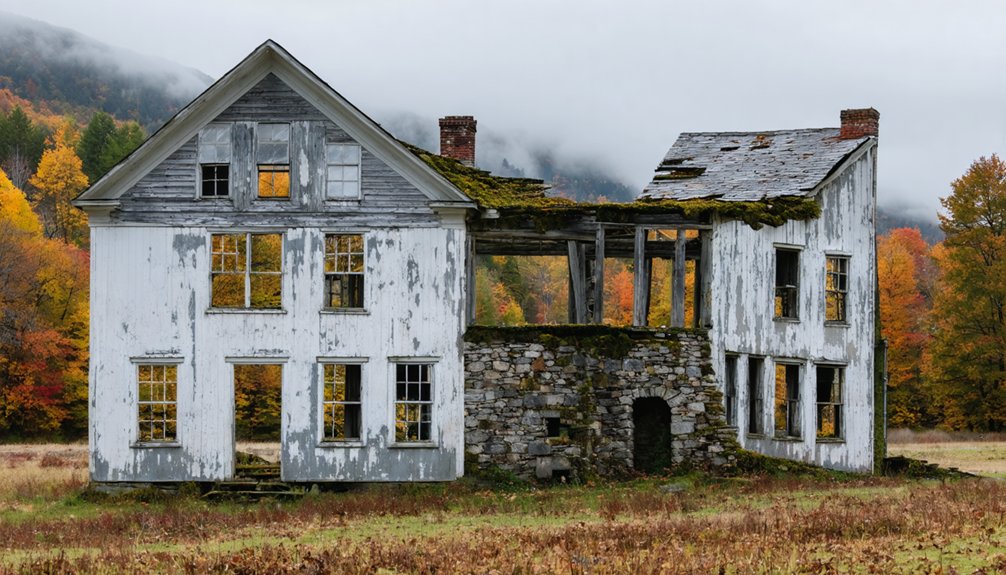
You’ll find Vermont’s most intriguing ghost towns scattered across the Green Mountains, from Greenbank’s Hollow in Caledonia County—where a five-story woolen mill once employed 45 workers before burning in 1885—to Glastenbury, the state’s most mysterious abandoned settlement linked to five unexplained disappearances. Somerset’s flooded ruins and Ricker Basin’s stone cellars tell stories of communities claimed by floods and failing soil, while South Vershire’s copper mining remnants mark an industrial past now reclaimed by forest. Below, you’ll discover exactly how to reach these haunting sites.
Key Takeaways
- Glastenbury: Vermont’s most mysterious ghost town, accessible via hiking trails through Green Mountain National Forest near Bennington Triangle.
- Greenbank’s Hollow: Former mill village in Caledonia County, now a preserved historical park with accessible ruins via dirt roads.
- Somerset: Southern Vermont settlement flooded by dam construction, reachable by forest service road off Molly Stark Byway with underwater ruins.
- Ricker Basin: 4,000-acre site with stone cellars and homestead foundations from mid-1800s, now overgrown and challenging to navigate.
- South Vershire (Copperfield): Abandoned copper mining boomtown with industrial remnants reclaimed by forest, marking Vermont’s mining heritage.
Greenbank’s Hollow: A Preserved Mill Town in Caledonia County
Tucked into a bend of Joe’s Brook in Caledonia County, Greenbank’s Hollow stands as one of Vermont’s most haunting reminders of 19th-century industrial ambition.
You’ll find marked foundations where Benjamin Greenbank’s five-story woolen mill once produced 700 yards of cloth daily, employing 45 workers who lived in this self-sufficient village.
At its peak, Greenbank’s mill employed 45 workers in a thriving, self-contained industrial village along Joe’s Brook.
The catastrophic 1885 fire—visible from Saint Johnsbury five miles away—ended everything in one night.
Unlike typical urban decay, preservation efforts by the Danville Historical Society transformed these ruins into an accessible historical park.
You can explore mill foundations, read informational exhibits, and walk to the National Register-listed covered bridge.
The village once included a post office and store, alongside a gristmill, sawmill, and school that served the close-knit manufacturing community.
The site sits at the intersection of Greenbanks Hollow Road and Brook Road, accessible via dirt and gravel roads that require extra caution during winter and spring conditions.
Each January, locals gather for a commemorative bonfire, keeping the hollow’s story alive through flames that echo its dramatic destruction.
Glastenbury: Vermont’s Most Mysterious Abandoned Settlement
You’ll find Glastenbury shrouded in more than just forest—five people vanished here between 1945 and 1950, earning it the chilling nickname “The Bennington Triangle.”
The most haunting disappearance remains Paula Welden’s: she hiked up the mountain in a bright red coat and simply dissolved into the wilderness, never to be seen again.
Reaching this ghost town requires serious backcountry navigation skills, as no maintained roads lead to the scattered ruins hidden beneath decades of regrowth on Glastenbury Mountain‘s slopes.
The town once thrived with nearly 250 residents around 1880, supported by logging operations, a sawmill, and even a post office that served the mountain community until 1878.
The settlement’s decline began with two murders in the 1890s, followed by devastating floods that washed out railroad tracks and forced the town’s disincorporation in 1937.
Mysterious Disappearances and Legends
While most Vermont ghost towns faded quietly into the forest, Glastenbury descended into darkness through a series of unexplained vanishings that still haunt the state’s collective memory.
Between 1945 and 1950, five people disappeared without trace near Glastenbury Mountain, earning the region its ominous nickname: the Bennington Triangle.
You’ll find urban legends warning against wearing red here—Paula Welden vanished in a crimson jacket in 1946.
Supernatural sightings include an eight-foot hairy creature documented since 1879, mysterious lights piercing the darkness, and a cursed boulder that supposedly swallows hikers whole.
The Abenaki tribe refused to hunt these slopes, speaking of a “human eating rock” and malevolent spirits.
The town’s troubled history included mysterious murders and various development schemes before its disincorporation in 1937.
Today, you can hike the Long Trail through this enigmatic wilderness, where unexplained phenomena still draw those seeking answers beyond conventional explanation.
The term “Bennington Triangle” was coined by author Joseph A. Citro, cementing the area’s reputation alongside other mysterious triangle phenomena.
Accessing the Ghost Town
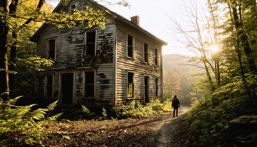
Reaching Glastenbury requires commitment—this ghost town lies deep within the Green Mountain National Forest, accessible only by hiking trails that wind through dense Vermont wilderness.
You’ll follow paths carved from old logging routes, where trolley tracks once carried tourists to mountain resorts before the devastating 1898 flood triggered evacuation procedures that never reversed.
Pack provisions for unmarked terrain—there’s no infrastructure, just overgrown ruins of mills, schools, and boarding houses reclaimed by forest.
The preservation challenges are evident: foundations crumble beneath moss, wooden structures have rotted away, and nature steadily erases human footprints.
The rocky terrain makes navigation particularly difficult, compounding the challenges faced by search parties throughout the area’s history.
Historian Tyler Resch first documented these sites in 1962, and you’ll need similar determination to locate remnants of Fayville and that enigmatic mountaintop cairn built from hauled stones where none naturally exist.
Somerset: A Forgotten Community in the Green Mountains
Deep in Vermont’s Green Mountains, where logging roads fade into wilderness, Somerset stands as one of the state’s most haunting examples of a town that engineered its own demise. Founded in 1761, this logging community stripped surrounding mountains bare, then constructed a dam that drowned its own prime land beneath Somerset Reservoir.
Somerset: a logging town that stripped its mountains naked, then built the dam that swallowed its own heart whole.
The environmental impact proved irreversible—from 321 residents in the 1880s to just two by 2000.
You’ll find Somerset’s coordinates at 42.9731, -72.9631, where local folklore intertwines with the mysterious Bennington Triangle. The town disincorporated in 1937, joining Glastonbury as one of Vermont’s rare abandoned municipalities. Early settlers reported unexplained phenomena throughout these 36 square miles:
- Strange lights piercing mountain darkness
- Unsettling sounds echoing through valleys
- Peculiar odors drifting from forests
- Creature sightings near waterways
- Multiple disappearances between 1945-1950
Access requires navigating a forest service road that plunges down an embankment off The Molly Stark Byway in Searsburg, deteriorating from pavement to gravel as it follows the Deerfield River into increasingly remote wilderness. Summer and fall offer ideal exploration conditions for this remote destination.
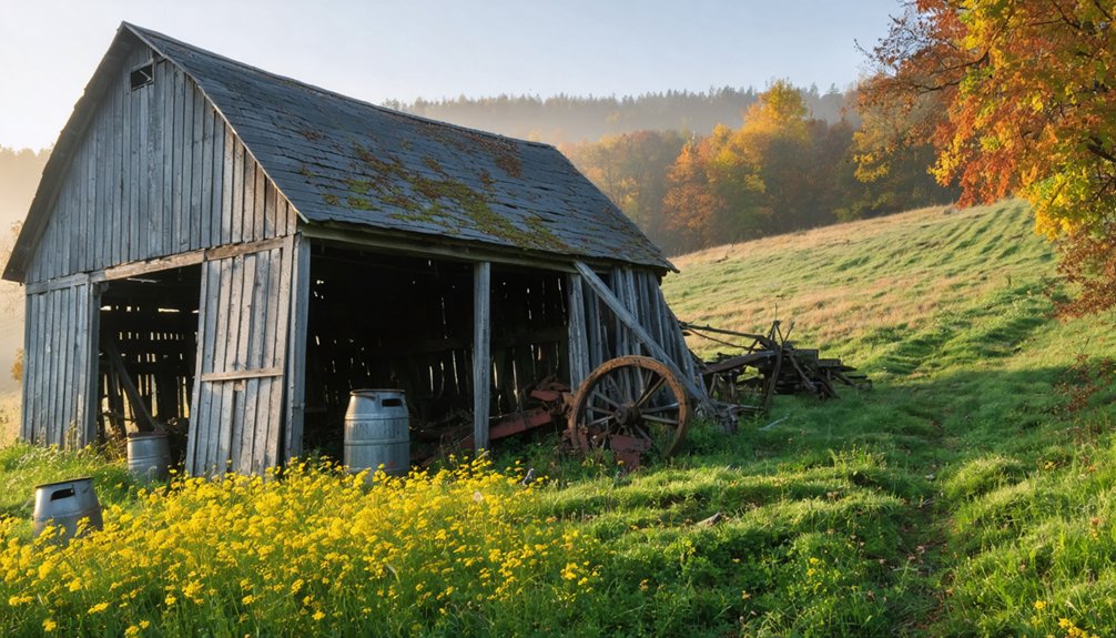
Ricker Basin: Traces of a Once-Vibrant Settlement
You’ll discover Ricker Basin’s haunting remnants scattered across 4,000 acres of southeastern mountainside, where stone-lined cellar holes and overgrown footpaths mark homesteads that once sheltered 50 families.
The community flourished in the mid-1800s around its sawmills and trading post, but rocky, unfertile soil doomed the farms while younger generations sought better prospects elsewhere. The 1927 flood caused by relentless rainfall sealed the community’s fate, followed by additional floods and the construction of Waterbury Dam that submerged remaining structures by 1934.
Stone Cellars and Footpaths
Scattered across the forested slopes of Ricker Basin, weathered stone cellars emerge from the leaf litter like monuments to vanished lives. You’ll discover these foundations along maintained trails in Green Mountain National Forest, where fifty families once carved out homesteads from unforgiving rocky terrain. The settlers incorporated cleared fieldstones directly into their cellar walls—a practical fusion of land-clearing and construction.
As you explore, you’ll find:
- Ancient footpaths connecting cellar holes to cemeteries and sawmill sites
- Stone foundations from the Almeran Goodell farmhouse
- Historic bridges marking former trading routes
- Underwater ruins preserved in the reservoir
- Old town roads still traceable through regrown forest
Trail maintenance guarantees these remnants remain accessible, while historic preservation efforts defend these tangible connections to Vermont’s agricultural past.
The dilapidated Goodell farmhouse still stands—a rare surviving structure haunting the hillside.
Community Rise and Decline
These silent stone foundations tell the story of Ricker Basin’s century-long existence, from Joseph Ricker’s initial farmstead in 1816 to the community’s eventual erasure beneath reservoir waters.
You’ll discover where fifty families once carved lives from rocky mountainside soil, building sawmills along rushing streams and raising sheep on slopes that ultimately betrayed them.
The infertile terrain forced younger generations elsewhere by the late 1800s, though a few stubborn holdouts remained until nature delivered its final verdict.
The catastrophic 1927 flood killed over fifty people regionally and obliterated riverside homes.
Today’s preservation efforts focus on protecting remaining cellar holes and cemeteries, while urban legends circulate about voices echoing across the reservoir at dawn—whispers from families who refused to abandon their mountain home.
Smith Family Farms: Remnants of Agricultural Heritage
- Stone mounds from 1780s clearing efforts still mark the landscape.
- The former dairy barn now houses heritage-breed pigs.
- Six generations of farming knowledge embedded in 265 conserved acres.
- Original infrastructure adapted for grass-fed beef production.
- Family legacy spanning 214 years across related properties.
- Sturdy boots and protective clothing against debris
- Headlamp for traversing collapsed structures
- GPS device with offline maps for signal-dead zones
- First aid kit and dust mask
- Property owner contact information
- Take only photographs, capturing decay’s artistry without disturbing artifacts
- Leave everything exactly as found—each rusted tool tells stories
- Pack out all waste, including that left by careless visitors before you
- Avoid removing “souvenirs”; historical items belong to the location’s narrative
- Mark your path with removable methods, never permanent graffiti or carvings
- https://kids.kiddle.co/List_of_ghost_towns_in_Vermont
- https://www.youtube.com/watch?v=2fvPo9iQC-w
- http://freepages.rootsweb.com/~gtusa/history/usa/vt.htm
- http://www.onlyinyourstate.com/experiences/vermont/ghost-town-vt
- https://www.geotab.com/ghost-towns/
- https://myfamilytravels.com/supposedly-boring-vermont-towns-hiding-some-truly-strange-landmarks
- https://www.hmdb.org/m.asp?m=61392
- https://danvillevthistorical.org/greenbanks-hollow/
- https://www.atlasobscura.com/places/the-forgotten-village-at-greenbanks-hollow-danville-vermont
- https://www.youtube.com/watch?v=YrQNbrIrNT8
You’ll find this isn’t abandonment—it’s evolution, where agricultural ghosts coexist with living tradition.
South Vershire (Copperfield): The Rise and Fall of a Copper Mining Town
Deep in Vermont’s hills, where forest now reclaims old industrial scars, you’ll find traces of what locals called Copperfield—a boomtown that once extracted 150 million pounds of copper from the earth. The Vermont Copper Mining Company transformed this wilderness into New England’s largest hard-rock mining operation after 1854, employing 900 souls who worked brutal 10-12 hour shifts underground.
Mining technology here was revolutionary: a 700-foot smelting plant processed ore that armed America through wars from the Civil to Korea. But freedom came at a cost. When 1883’s labor disputes erupted, striking miners seized explosives and controlled the town until 200 militia restored order.
Today, you’ll walk through silence where picks once rang—a monument to those who refused exploitation.
What to Bring When Exploring Vermont’s Ghost Towns
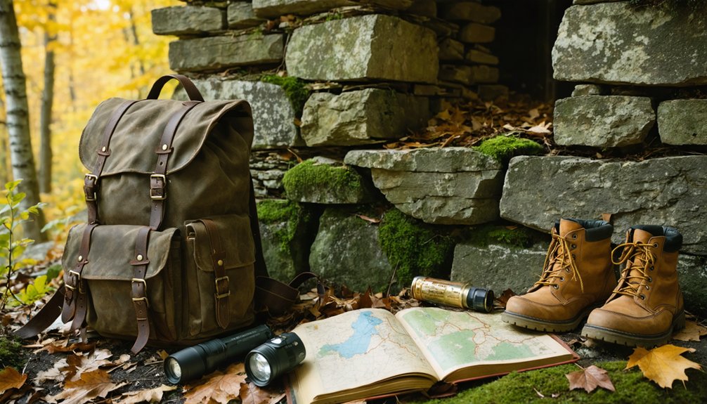
Before you venture into Vermont’s forgotten settlements, pack like you’re entering territory that respects neither carelessness nor romanticism. These ghost towns demand preparation that balances adventure with survival intelligence.
These ghost towns in Vermont history tell stories of a thriving past, where communities once bustled with life. As you explore their remnants, you’ll uncover the challenges faced by early settlers and the reasons these places faded into obscurity. Each visit offers a haunting glimpse into history, reminding us of the resilience and fragility of human endeavor.
Essential gear for your exploration:
Safety tips learned from experience: always notify someone of your location before entering abandoned sites.
Pack weather-resistant layers—Vermont’s microclimates shift without warning. Bring insect repellent targeting ticks in overgrown settlements.
Carry backup power for your phone and a whistle for emergencies. Document boundaries to avoid trespassing charges that’ll end your ghost town adventures permanently.
Best Times of Year to Visit Abandoned Sites
Timing your ghost town exploration in Vermont means wrestling with a state that reveals different secrets depending on the season. You’ll find the sweet spot between Labor Day and late September—crisp nights, golden light, and trails empty of leaf-peepers. Weather conditions stay stable for bushwhacking to Ricker Basin or Tyson Furnace without fighting snow or mud.
October brings seasonal foliage that’ll steal your breath, but you’re sharing Glastenbury with Instagram crowds. Winter opens snowshoe access to isolated sites, though short days cut exploration time. I’ve tramped through February drifts to abandoned mill foundations—the silence is absolute, but you’re racing darkness by 4 PM.
Summer works for Lake Champlain ghost towns, combining warm-weather stamina with harvest-season detours through the Champlain Islands.
Respecting History: Guidelines for Ghost Town Exploration
Stepping into Vermont’s ghost towns carries weight beyond curiosity—you’re entering spaces where people worked, lived, and buried their dreams.
Ghost towns aren’t just ruins—they’re monuments to real lives, real struggles, and communities that once thrived before fading into silence.
Historical significance demands respect through preservation ethics that honor these vanished communities.
Your footsteps matter. Document through photography, leaving structures untouched:
These abandoned places survived decades of weather and neglect.
Don’t let your visit become the final insult. Written permission protects you legally while demonstrating genuine respect for property owners who’ve maintained these historical remnants for explorers like yourself.
Frequently Asked Questions
Are There Any Guided Tours Available for Vermont’s Ghost Towns?
You won’t find guided tours of Vermont’s actual ghost towns—they’re too busy offering “haunted” pub crawls. Instead, you’ll discover abandoned settlements through self-guided exploration, offering historical preservation insights and incredible photography opportunities amid crumbling foundations and overgrown streets.
While wandering through abandoned sites in Vermont’s fall, you may stumble upon remnants of old stone walls and rusted machinery slowly being reclaimed by nature. The vibrant foliage provides a striking contrast to the decay, making each snapshot a unique blend of color and history. These forgotten places tell stories of a bygone era, inviting you to ponder the lives once lived amidst their shadows.
Can I Camp Overnight Near These Abandoned Settlements?
You’ll need to follow Vermont’s camping regulations carefully—stay 200 feet from trails and water. Take safety precautions since these areas are remote and unstable. Green Mountain National Forest offers the most freedom for dispersed camping nearby.
Do I Need Special Permits to Visit These Ghost Town Sites?
You won’t need special permits for most sites—Vermont has no statewide ghost town permit system. However, historical preservation laws protect artifacts, and preservation restrictions ban metal detecting, with fines reaching $10,000 for violations.
Are These Locations Safe for Children and Elderly Visitors?
Safety precautions matter—slippery rocks and uneven terrain pose accessibility concerns for elderly visitors and young children. You’ll want sturdy footwear and supervision. Some sites lack railings, so assess each location’s conditions before bringing vulnerable family members along.
What Other Ghost Towns Exist in Vermont Besides These Six?
You’ll find additional Vermont ghost towns like Ricker Basin and Podunk scattered across the state. Local legends surround these sites, though historical preservation efforts vary. Many remain hidden on private land, requiring permission and respect for property boundaries before exploring.
In addition to Ricker Basin and Podunk, there are many other ghost towns to explore in Vermont that reveal stories of the past. Each location offers a unique glimpse into the state’s rich history and the remnants of 19th-century life. As you venture through these abandoned places, keep an eye out for intriguing artifacts and stunning views that capture the essence of Vermont’s forgotten landscapes.
Among these abandoned sites in Vermont, you’ll discover remnants of old mills and crumbling homes that tell tales of the families who once thrived there. Each location not only reflects the architectural styles of their time but also serves as a canvas for nature’s reclamation. As you walk these forgotten paths, you might just feel the whispers of history echoing all around you.


