You’ll find Nebraska’s ghost towns at their most haunting in winter, when snow reveals what summer grass conceals. Antioch’s WWI-era potash ruins stand open and free to explore, while Brocksburg’s leaning homesteads hide along the remote northern border among wildlife tracks. St. Deroin’s relocated structures and petroglyphs lurk within Indian Cave State Park, shrouded in paranormal legends. Steele City’s limestone church and railroad relics create perfect fog-draped photography opportunities, and Oreapolis—Nebraska’s official ghost town—emerges clearest when ice grips the river confluence where ambitious dreams collapsed into scattered foundations.
Key Takeaways
- Antioch: Visit Nebraska’s “potash capital” ruins year-round without fees, exploring preserved WWI-era factories 15 miles east of Alliance on Highway 2.
- Brocksburg: Explore remote northern border settlement with leaning buildings and 1890s tornado shelters; winter reveals wildlife tracks and requires high-clearance vehicles.
- St. Deroin: Discover paranormal legends, ancient petroglyphs, and sandstone caverns within Indian Cave State Park when winter opens scenic Missouri River views.
- Steele City: Photograph historic 1882 limestone church and abandoned railroad infrastructure enhanced by winter fog, ice, and receded undergrowth in Little Blue River valley.
- Oreapolis: Access Nebraska’s “most ambitious failure” easily in winter when vegetation clears, revealing foundations near Platte-Missouri confluence and historic ferry crossings.
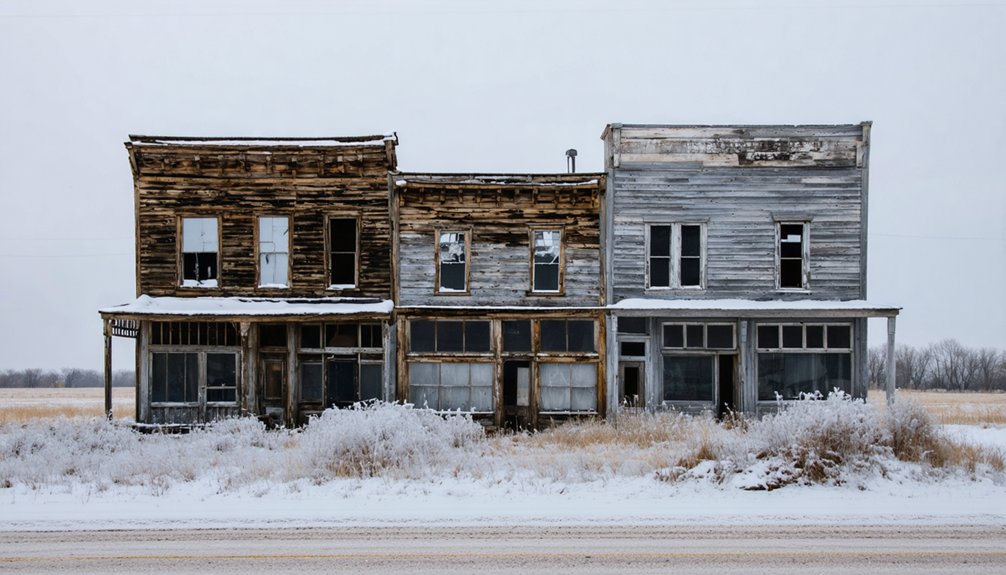
Antioch: The Former Potash Capital Frozen in Time
Fifteen miles east of Alliance along Nebraska Highway 2, the skeletal remains of Antioch rise from the Sandhills like tombstones marking an industrial graveyard. You’ll find crumbling foundations where five potash industry factories once roared with 5,000 workers during World War I’s boom years.
Winter strips away any romantic notions—frozen wind whips through empty ruins, and snow reveals the stark geometry of what remains. The potash industry transformed this sleepy village into Nebraska’s “potash capital” by 1918, then vanished when German imports returned in 1921.
Today, fewer than 25 souls inhabit this National Register site. Ghost town preservation here means leaving history untouched—no gates, no fees, just you wandering freely among foundations where fortunes rose and fell within five frantic years.
Brocksburg: Hidden Homesteads Along the Outlaw Trail
While Antioch’s industrial bones lay exposed on the prairie, Brocksburg hides its secrets among cottonwood groves along Nebraska’s remote northern border. You’ll need high-clearance vehicles and serious commitment to reach Henry Brockman’s 1890s settlement near the South Dakota line. The rugged approach off Highway 12 rewards you with leaning structures and a century-old tornado shelter—remnants of pioneer toughness that served scattered ranching families until 1957.
Winter transforms these hidden homesteads into something extraordinary. Snow-covered terrain reveals winter wildlife sightings: deer tracks circling abandoned foundations, coyotes haunting the Keya Paha River bridge where three residents drowned in a 1920s ice gorge tragedy. Like Montrose’s solitary church, Brocksburg’s remaining structures stand as symbols of both pioneer determination and eventual surrender to time. The town’s post office operated continuously until the 1950s, serving as a lifeline for remote homesteaders.
Local hauntings and legends whisper through bare branches, while GPS failure forces you to trust instinct alone in this authentic ghost town experience.
St. Deroin: Haunted Remains at Indian Cave State Park
Where else can you explore a haunted ghost town where 300,000 annual visitors hike past cemetery whispers and phantom hoofbeats? St. Deroin within Indian Cave State Park offers precisely that freedom.
Founded in 1854, this ferry hub died when the Missouri River shifted 5-10 miles away by 1915, leaving floods to claim everything below.
You’ll discover paranormal activity woven through historic preservation efforts. Joseph Deroin’s spectral horse still gallops near the cemetery after his 1858 murder over a $6 hog debt.
A.J. Ritter’s disembodied arm searches moonless nights after a dynamite fishing disaster.
Two relocated structures overlook the vanished river while you track cerulean warblers and pileated woodpeckers through winter woods. The park’s sandstone cavern holds ancient petroglyphs depicting wild animals and a man on horseback.
A lookout shelter provides scenic views revealing how far the river has moved from its original position near the town.
Park staff share these legends around crackling campfires.
Steele City: Railroad Relics Perfect for Snowy Photography
Frost-kissed limestone walls and skeletal railroad infrastructure transform Steele City into a photographer’s winter sanctuary. You’ll discover the 1882 Baptist Church’s Romanesque façade, where Arthur Bower’s craftsmanship in Kansas limestone creates dramatic contrasts against fresh snowfall. The massive round cathedral window becomes your centerpiece for architectural documentation.
Railroad preservation efforts remain visible throughout this 47-resident settlement founded in 1873 along the St. Joe and Western Railway. Winter photography tips come alive here: capture abandoned brick buildings emerging through morning fog, weathered garage structures framed by bare branches, and deteriorating facades where ice crystallizes forgotten stories. The town’s historic buildings and architecture stand as testament to its boom years when the railroad brought commerce and population to this once-thriving settlement. Nestled in the heavily wooded valley of the Little Blue River, the town’s picturesque setting provides natural framing for winter compositions.
You’re free to wander empty main street corridors near the Kansas border, documenting authentic decay without crowds. Each crumbling structure whispers Nebraska’s railroad heritage through snow-muffled silence.
Belvidere: Oregon Trail Outpost in the Winter Landscape
The memorial flower garden near the depot becomes starkly beautiful under snow, while local flora along the creek banks attracts winter birdwatching opportunities. Informational signs trace Oregon Trail heritage through frozen landscapes you can photograph from nearby Highway 81.
Eight acres of Thayer County Historical Society exhibits await when frost drives you indoors, preserving stories of Indian encampments and pioneer determination that shaped this vanishing outpost. Similar to Spring Ranch, which was burned during Indian raids and rebuilt across the river, these settlements faced constant frontier challenges.
The town’s position along Big Sandy Creek provided crucial water access for early settlers who established this community in 1873. Year-round train enthusiasts can witness freight and coal trains passing through every 10-15 minutes on the historic double-tracked line that once made Belvidere a major grain transportation hub.
Oreapolis: Nebraska’s Official Ghost Town by the River
You’ll find Nebraska’s most ambitious failure where the Platte meets the Missouri—a site where Dr. John Evans’ 1857 dream of building the West’s greatest railroad hub collapsed before it truly began.
The Panic of 1857 devastated his vision of a metropolis rivaling Chicago and San Francisco, leaving only scattered foundations visible among winter’s stark riverside landscape.
Today, you can trace the ghost of those 276 planned city blocks along frozen riverbanks, imagining the ferry crossings and bustling commerce that existed for merely five years before vanishing completely.
John Evans’ Failed Vision
Standing in his 55 Clark Street office in Chicago, real estate tycoon John Evans envisioned something audacious: the greatest city between Chicago and San Francisco would rise where the Platte and Missouri Rivers converged.
The Evanston namesake’s 1857 Oreapolis Town Company promised:
- A thriving university and seminary anchoring intellectual life
- Ferry service connecting Missouri River commerce
- 50 houses with hotels, banks, and lumber yards under construction
- 1,000 inhabitants within two years of settlement
You’ll find none of this today. Where Evans forecast urban dominance, only windswept prairie remains. His surveys and plat maps became obsolete parchment.
The predicted gateway to the American West dissolved into economic decline and urban abandonment—a cautionary tale of ambition meeting Nebraska’s unforgiving reality at an empty river junction.
1857 Economic Crisis Impact
While John Evans drafted his ambitious blueprints in Chicago, the Panic of 1857 was strangling American credit markets and bankrupting land speculators across the frontier. Yet this Chicago real estate tycoon saw opportunity where others saw ruin.
From his office at 55 Clark Street, he launched the Oreapolis Town Company on October 30, 1857—defying the economic catastrophe swirling around him. You’ll find it remarkable that he filed incorporation papers and completed plat maps while banks were collapsing nationwide.
His gamble on economic resilience failed spectacularly. The town limped along until 1864, never achieving the market recovery Evans envisioned.
That junction of the Platte and Missouri Rivers, once destined to rival Chicago itself, became Nebraska’s cautionary tale of frontier ambition crushed by economic reality.
Winter River Exploration Today
When winter ice grips the confluence of the Platte and Missouri Rivers, Oreapolis reveals itself most completely. You’ll navigate where steamboats once dominated this essential waterway, though modern boat tours cease when temperatures plummet.
The frozen landscape strips away summer’s concealing vegetation, exposing foundations and street patterns that hills and undergrowth typically hide.
Your winter exploration should include:
- Ice fishing near the historic ferry crossing where immigrants once set out westward
- Tracking the oak-grown gulches and ravines that shaped this vanished settlement
- Locating the Lone Tree saloon site beneath tangled branches and snow
- Standing where four states meet your gaze across the restless Missouri
You’re free to wander unmarked terrain, discovering Nebraska’s official ghost town without crowds or restrictions.
Frequently Asked Questions
What Safety Precautions Should I Take When Exploring Abandoned Buildings in Winter?
You’ll need essential safety gear before urban exploration: sturdy boots for icy surfaces, a reliable flashlight, protective masks against mold, and emergency communication devices. Always inspect structural integrity, watch for wildlife, and notify someone of your location.
Are Nebraska Ghost Towns Accessible During Heavy Snowfall and Blizzard Conditions?
Near Harrison, blizzards trap travelers for days, burying roads under impassable drifts. You’ll find Nebraska’s ghost towns—rich in historical significance and local legends—become dangerously inaccessible during heavy snowfall. Wait for clearer conditions before exploring these vanished settlements freely.
Do I Need Permits to Photograph or Explore These Ghost Town Sites?
You won’t need legal permissions for exploring most abandoned ghost towns, as they’re typically on public land. However, photography regulations require permits only if you’re conducting commercial shoots with professional equipment and paid models.
What Winter Gear and Emergency Supplies Are Essential for Ghost Town Trips?
You’ll need layered winter clothing including merino wool base layers, insulated boots rated to extreme cold, and waterproof outerwear. Pack emergency kits with navigation tools, first-aid supplies, extra food, water, and communication devices for remote exploration safety.
Can I Camp Overnight Near These Ghost Towns During Winter Months?
You’ll find limited winter camping near ghost towns, but dispersed BLM sites allow 14-day stays. Historical preservation often restricts overnight access. Instead, you’ll discover freedom exploring local legends by day, then camping at nearby state parks with that 30% winter discount.
References
- https://www.onlyinyourstate.com/trip-ideas/nebraska/ne-ghost-towns-road-trip
- https://negenweb.us/knox/stories/ghosttowns.htm
- https://www.youtube.com/watch?v=l3s2qhSxis8
- https://www.youtube.com/watch?v=gT2faoIOoAA
- https://history.nebraska.gov/oreapolis-nebraskas-ghost-town/
- https://visitnebraska.com/trip-idea/explore-7-authentic-ghost-towns-nebraska
- https://freepages.rootsweb.com/~gtusa/history/usa/ne.htm
- https://en.wikipedia.org/wiki/Antioch
- https://hcsghosttowns.wordpress.com/nebraska/antioch-nebraska/
- https://www.hmdb.org/m.asp?m=178812


