Winter transforms Oklahoma’s ghost towns into stark landscapes where you’ll find chat piles towering over evacuated Picher, frontier stone ruins at Boggy Depot State Park, and weathered Route 66 relics in Texola. You can explore the Doolin-Dalton Gang’s bullet-scarred hideouts in Ingalls, hike to Black Mesa’s summit near remote Kenton, or wander Skedee’s abandoned storefronts where sixty residents remain. Cold months reveal foundations hidden by summer vegetation, sharpen the High Plains’ desert vistas, and cast dramatic light across petroglyphs—each site holding deeper stories of outlaws, environmental disasters, and frontier resilience.
Key Takeaways
- Picher offers toxic chat piles and abandoned mining structures, with 86% unstable ground from tunnels beneath the EPA-evacuated town.
- Texola features weathered Route 66 landmarks including the 1930 Magnolia Service Station and the 1910 Territorial Jail on quiet streets.
- Kenton provides Black Mesa’s highest elevation, petroglyphs, dinosaur tracks, and museum artifacts in Oklahoma’s remote High Plains region.
- Ingalls displays Wild West outlaw hideout replicas and ruins from the 1893 Doolin-Dalton Gang ambush east of Stillwater.
- Skedee shows post-flood decline with the 1926 Bond of Friendship monument, abandoned storefronts, and a woodland-reclaimed calaboose jail.
Picher: Walking Through Environmental History and Outlaw Legends
When you first approach Picher in winter, the skeletal remains of what was once Oklahoma’s most prosperous mining town emerge through bare trees like a warning from history.
You’ll walk past towering chat piles—some reaching 200 feet—that dominate the landscape like monuments to extraction.
The chat piles rise like artificial mountains, stark reminders of an industry that consumed everything beneath them.
This toxic legacy includes lead contamination and unstable mine tunnels beneath 86% of former structures.
The mining history here’s extraordinary: 14,000 miners once worked these operations, supporting a thriving community of over 14,000 residents by 1926.
The town produced more than 50% of lead and zinc used in World War I, contributing to over $20 billion in ore between 1917 and 1947.
After the devastating 2008 tornado and EPA evacuation, Picher’s disincorporation in 2009 left behind boarded-up buildings and “Keep Out” warnings.
The town was officially named for O.S. Picher, owner of Picher Lead Company, following Harry Crawfish’s discovery of the ore deposits in 1913.
You’re free to explore cautiously, witnessing how environmental catastrophe transformed prosperity into abandonment.
Boggy Depot State Park: Oklahoma’s Most Accessible Frontier Ruins
You’ll find weathered stone foundations rising from the grass at Boggy Depot, marking where frontier buildings once thrived as the bustling heart of the Choctaw and Chickasaw Nations. Follow the nature trail through this 35-acre site to discover remnants of the old apothecary, hotel, and blacksmith shop, their limestone walls standing as silent witnesses to a town that served as a Confederate supply depot and stagecoach stop.
The historic cemetery beckons beyond the ruins, where Choctaw Chief Allen Wright—the man who coined the name “Oklahoma”—rests among pioneers and citizens whose stories span Indian Territory’s most pivotal decades. Look for the faint stagecoach ruts that still mark the old Butterfield Overland route cutting through the park, a reminder of when this isolated outpost connected travelers between Missouri and California. The site gained unexpected recognition when guitarist Jerry Cantrell named his 1998 album after this ghost town where his father grew up, bringing national attention to this forgotten corner of Oklahoma history.
Stone Ruins and Trails
While most Oklahoma ghost towns require bushwhacking through private property or deciphering cryptic directions, Boggy Depot State Park delivers authentic frontier ruins straight to your car door. You’ll find stone foundations scattered across 35 acres—archaeological sites that earned National Register recognition in 1972.
These remnants of a once-thriving Civil War commissary depot tell stories of urban decay that began when the railroad bypassed the town in 1872.
Nature trails wind through wooded landscape, offering routes for both beginners and experienced hikers.
Ground swells near the former church reveal Butterfield Stage ruts, though the actual wagon tracks lie just beyond the back fence. The on-site cemetery holds the grave of Choctaw Chief Allen Wright, who gave Oklahoma its name meaning “Red People” in the Choctaw language.
Information markers guide your exploration year-round, letting you discover this frontier ghost town without trespassing or maneuvering unmarked territory. Plan your visit during cooler months when Oklahoma’s heat won’t limit your time exploring the ruins and historical features.
Historic Cemetery Exploration
Beyond the stone foundations and nature trails lies Boggy Depot Cemetery, the oldest burial ground in Atoka County and the sole surviving feature of the original townsite. You’ll discover ancient gravestones marking the final resting places of Choctaw and Chickasaw citizens, including Chief Allen Wright—the visionary who coined “Oklahoma,” meaning “Red People” in Choctaw.
Winter greenery surrounds the historic markers, creating a contemplative atmosphere as you explore this National Register site.
The cemetery’s year-round accessibility lets you wander freely among rolling hills between Clear Boggy and Sandy creeks. Informational signs guide your journey through frontier history, while nearby trails connect you to Oklahoma’s untamed past. Here you’ll walk the grounds where Chickasaw Indians founded their western settlement in 1837, establishing what would become a vital crossroads of the frontier. The site hosts community gatherings on Memorial Day and Veterans Day, continuing its role as a place of remembrance.
This protected burial ground represents the territory’s authentic spirit—a place where freedom-seekers carved civilization from wilderness.
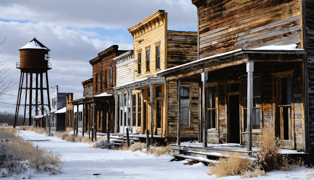
Texola: Route 66 Remnants Along the Texas Border
You’ll find the Magnolia Service Station standing at the intersection of Grand Avenue and Broadway, a crumbling sentinel that’s anchored this corner since Route 66’s heyday and earned its place on the National Register of Historic Places in 1995.
The station’s weathered facade tells the story of countless travelers who stopped here on their journey west, now silhouetted against winter’s pale High Plains sky.
In the stark midday light of an Oklahoma winter, these abandoned structures reveal their bones—peeling paint, collapsed roofs, and empty windows that frame the endless horizon stretching toward Texas.
Walking through Texola’s quiet streets, you’ll encounter old storefronts that have lost their windows and purpose, their plywood-covered porches and missing doors marking the town’s decline from its Route 66 glory days.
On the west side of town stands the 1910 Territorial Jail, a minimal one-cell structure that serves as both a historical curiosity and a stark reminder of frontier justice.
Magnolia Service Station History
At the dusty intersection of Grand Avenue and Broadway, where Route 66 splits into two weathered ribbons of asphalt, the Magnolia Service Station stands as a skeletal reminder of Texola’s roadside glory.
Built around 1930, this simple box-and-canopy structure marketed Magnolia Petroleum Products when the town peaked at 581 residents.
You’ll find it listed on the National Register of Historic Places since 1995, though architectural preservation efforts have lagged behind recognition.
The station’s rough edges tell authentic stories of heritage tourism‘s forgotten monuments—weathered paint, sagging timbers, and crumbling concrete speak louder than polished restorations ever could.
Without intervention, this tangible link to Route 66’s commercial heyday faces collapse.
Visit now while you still can explore this unvarnished piece of highway history.
High Plains Winter Landscape
Where else does winter strip away pretense quite like Texola’s high plains borderland, where Oklahoma’s westernmost stretch of Route 66 dissolves into Texas?
You’ll find brutal honesty in December’s unfiltered midday light exposing abandoned storefronts along Grand Avenue. Snow-covered horizons stretch endlessly across these Dust Bowl plains, where tumbleweeds gather against derelict buildings like skeletal monuments to commerce past.
Winter wildlife—coyotes and jackrabbits—claim what humans abandoned decades ago. The stark landscape reveals what summer heat obscures: ruined hotels, empty auto camps, and weathered Route 66 shields painted on crumbling pavement.
This is freedom’s edge, where civilization thins to thirty-six souls and a one-room jail. Walk these dusty streets when winter wind howls, and you’ll understand why some called this stretch the loneliest highway in America.
Ingalls: The Uncharted Wild West Haven Near Stillwater
Imagine stumbling upon a windswept prairie crossroads where outlaws once traded gunfire with federal marshals, and you’ve found Ingalls—Oklahoma’s most notorious ghost town. Ten miles east of Stillwater, this forsaken settlement harbors pioneer stories etched in crumbling stone foundations and weathered ghost town architecture.
On September 1, 1893, the Doolin-Dalton Gang’s sanctuary erupted in chaos when U.S. Marshals ambushed them, leaving five dead in the streets.
You’ll discover replicas of the livery stable and saloon where desperadoes like Dynamite Dick Clifton once hid, plus Mary Pierce’s O.K. Hotel ruins.
A stone monument honors the fallen lawmen near the old fire station.
Winter strips away the prairie’s disguise, revealing Ingalls’ skeletal remains—rusted signs, scattered foundations, and the stubborn defiance of a town railroads abandoned to history’s mercy.
Kenton: High Plains Ghost Town With Mesa Vistas
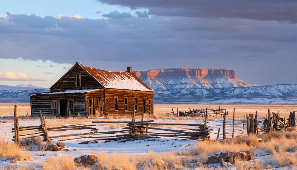
How does Oklahoma’s most remote ghost town cling to existence where the High Plains collide with the state’s highest peak? Kenton sprawls across the Cimarron River valley with just 31 souls, remnants of a wild outlaw past when Captain William Coe’s fortress sheltered rustlers beyond all jurisdiction.
Where lawless frontier history intersects with High Plains isolation, 31 residents preserve Oklahoma’s wildest outpost against erasure.
You’ll discover winter’s stark beauty here, where preserved history meets untamed landscape.
Your winter exploration includes:
- Black Mesa hiking trails reaching Oklahoma’s highest elevation with mountain sunset views
- Ancient petroglyphs and dinosaur tracks embedded in Carrizo Creek sandstone
- America’s darkest skies—Milky Way blazing overhead on moonless nights
- Kenton Museum’s No Man’s Land artifacts inside a 1902 native rock residence
The Mercantile building still stands, displaying mammoth bones from prehistoric times. Ten miles north, you’ll find the tripoint monument where three states converge.
Skedee: A Modern Ghost Town Off the Beaten Path
Tucked six miles northeast of Pawnee in the rolling prairie, Skedee stands as Oklahoma’s most accessible ghost town—a community that hasn’t quite surrendered to oblivion. You’ll find roughly 60 souls still claiming residence among structures slowly succumbing to urban decay.
The 1926 Bond of Friendship monument—depicting Colonel Walters shaking hands with Osage Chief Baconrind—rises from the landscape like a controversial testament to oil-boom prosperity.
Winter exposes Skedee’s skeleton: abandoned storefronts with scattered keepsakes, the hidden calaboose reclaimed by woods, and Colonel Walters’ home defying time.
The 1957 flood destroyed the railroad, accelerating decline from 375 residents to today’s remnant population.
Historical preservation here means embracing decay—you’ll witness authentic deterioration without tourist infrastructure constraining your exploration.
Frequently Asked Questions
What Safety Precautions Should I Take When Exploring Abandoned Buildings in Winter?
Watch for hazardous structures like rotting floors and collapsing roofs. Dress in layers to combat hypothermia risks from freezing temperatures. You’ll want sturdy boots for icy debris, a headlamp for dark corridors, and always tell someone your location.
Are There Guided Tours Available for Oklahoma Ghost Towns During Winter Months?
You’ll find no guided winter tours specifically for Oklahoma’s slumbering settlements. However, you can explore history preservation through the self-guided Pocketsights app, discovering local legends at ghost towns like Ingalls and Skedee at your own pace year-round.
Do I Need Special Permits to Photograph or Explore These Ghost Town Sites?
Most Oklahoma ghost towns don’t require photography permits since they’re on public or abandoned land. However, you’ll face access restrictions on private property—always respect “No Trespassing” signs and seek landowner permission before exploring these hauntingly beautiful ruins.
What Winter Clothing and Gear Are Essential for Ghost Town Visits in Oklahoma?
You’ll need winter dress built on layered clothing—moisture-wicking base layers, insulating flannel mid-layers, and wind-resistant outer shells. Don’t forget wool socks, sturdy boots, gloves, and a beanie to explore Oklahoma’s abandoned landscapes comfortably and freely.
Can I Camp Overnight Near Any of These Ghost Town Locations in Winter?
You’ll find overnight camping at Boggy Depot State Park year-round, while other locations require driving to nearby campgrounds. Follow winter camping tips and prioritize abandoned building safety—never shelter inside unstable structures during your explorations.
References
- https://myfamilytravels.com/these-oklahoma-ghost-towns-locals-visit-for-peaceful-winter-walks/
- https://en.wikipedia.org/wiki/List_of_ghost_towns_in_Oklahoma
- https://z94.com/explore-oklahoma-ghost-towns/
- https://www.youtube.com/watch?v=5XQUmVjjrZw
- https://abandonedok.com
- https://allthatsinteresting.com/picher-oklahoma
- https://adamthompsonphoto.com/the-sad-tale-of-picher-oklahoma/
- https://www.okhistory.org/publications/enc/entry?entry=PI002
- https://www.youtube.com/watch?v=yGZeoW8lLdU
- https://www.youtube.com/watch?v=0KnAr4swnT8


