You’ll discover South Dakota’s most atmospheric ghost towns along the snow-covered corridors of the Black Hills, where Mystic’s 1876 railroad ruins stand frozen against pine slopes and Spokane’s silver mining remnants rest at Custer State Park’s edge. Okaton’s abandoned storefronts face prairie winds near I-90, while Rochford’s skeletal structures become accessible when ice hardens muddy forest roads. Winter transforms these settlements into photographer’s dreams—frost outlining weathered boards, wildlife tracks crossing empty streets, and mountain silence replacing century-old echoes. The experience deepens when you understand the routes, gear, and hidden corners that make these frozen ruins unforgettable.
Key Takeaways
- Mystic features intact 1876 railroad architecture with restored schoolhouses and the historic Reduction Mill accessible along snow-covered former rail lines.
- Spokane offers silver mining remnants at Custer State Park’s edge, including abandoned schoolhouses and glacial scars from 1920s operations.
- Okaton displays prairie ghost town relics like faded storefronts and grain elevators, abandoned after 1980s railroad departure.
- Winter access via Route 385 and Iron Mountain Road provides reliable paved routes through pine forests to multiple ghost town sites.
- Essential winter gear includes heavy boots, layered clothing, maps, and emergency supplies due to icy conditions and no cell coverage.
Mystic: A Historic Railroad Town in the Black Hills
Deep in the Black Hills, where Sitting Bull Creek cuts through pine-covered slopes, the mining camp that would become Mystic first took root in 1876.
Nestled where Sitting Bull Creek winds through dense pines, Mystic emerged as a Black Hills mining camp in 1876.
You’ll find ghost town architecture that’s remarkably intact—the restored schoolhouse stands alongside original buildings that’ve weathered everything from gold rushes to the Great Depression.
What sets Mystic apart is its railroad heritage. Two lines once converged here: the Chicago, Burlington & Quincy in 1889, and the engineering marvel known as the Crouch Line in 1906, featuring fourteen circles and one hundred bridges carved into impossible terrain. The devastating 1907 flooding destroyed all but five of these bridges, though the railroad recovered and continued operations.
The Mystic Reduction Mill, built in 1900, once processed 150 tons of ore daily using an advanced electro-cyanide process before shutting down in 1913.
Today’s historical preservation efforts let you explore this past firsthand. Access the Mystic Trailhead on the Mickelson Trail, where you’ll hike the old railroad route through stunning winter vistas.
Ardmore: Agricultural Remnants Near the Nebraska Border
You’ll find Ardmore’s white experimental farm barn still perched on the hill above town, a weathered monument to the government’s failed 1911 dry farming venture that promised to transform this harsh landscape.
The town somehow clawed through the Great Depression without a single family on welfare, even as the very experiments meant to save it collapsed under relentless drought through the 1930s.
Standing among the 15-25 abandoned structures today, you’re witnessing the bones of a community that survived America’s hardest decade only to be undone by diesel locomotives and dust. Founded in 1889 as a railroad stop, Ardmore once supplied acidic water from Hat Creek to refuel steam engines traveling near the South Dakota-Nebraska border.
Located roughly one mile north of the South Dakota-Nebraska border along Highway 71, the site remains accessible to visitors drawn to its frozen-in-time frontier atmosphere.
Government Farming Experiment Legacy
Along the desolate stretch of Highway 71, just one mile north of the Nebraska border, Ardmore’s weathered buildings stand as monuments to agricultural ambition gone wrong. You’ll discover remnants of the government’s bold 1911 dry farming experiment, where federal scientists tested crop rotations and livestock operations across virgin prairie sod.
This farming innovation promised prosperity in arid conditions without irrigation, but persistent drought crushed those dreams by the late 1920s.
Today, you’re free to photograph decaying homes and experimental fields frozen in time, though no-trespass signs guard some structures. The experimental station’s research, documented in a 16-page bulletin, revealed that rainfall fluctuations caused such extreme yield variability that cultural methods alone could never stabilize crop production. The town’s agricultural history reads like a cautionary tale—16 residents remained by 1980, clinging to what became a ghost town.
Walking these barren grounds, you’ll witness how even government-backed ventures couldn’t conquer nature’s unforgiving grip.
Depression-Era Town Resilience
While the Great Depression devastated communities across America, Ardmore’s residents achieved something remarkable—not a single family required welfare assistance throughout the entire 1930s.
This Depression resilience speaks to a frontier spirit that refused government dependence, even as drought scorched their land and acidic Hat Creek water made survival grueling.
You’ll find their community endurance etched in the 15-25 abandoned homes lining Highway 71. These weathered structures tell stories of families who persevered when the railroad disappeared after 1929, when dry farming experiments failed, and when their town transformed into what observers called a “decaying ghost town” by 1936. The white experimental farm barn, perched high on a hill and visible from Hot Springs, stands as a monument to the government’s early 1900s agricultural testing that once brought prominence to this isolated settlement. Among the weathered buildings, you’ll discover scattered classic cars left across the lots, their rusted frames creating an eerie post-apocalyptic atmosphere that speaks to the sudden nature of the town’s abandonment.
The volunteer fire station still hosts biennial reunions—a testament to bonds forged through shared hardship, where self-reliance wasn’t just valued, it was survival.
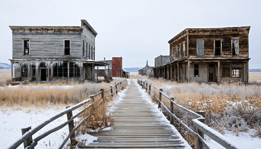
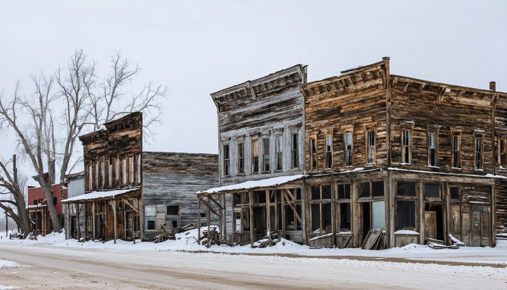
Okaton: Roadside Relics From a Bygone Era
Rising from the windswept prairie like a film set frozen in time, Okaton’s weathered storefronts and sagging structures tell the story of America’s westward expansion and its inevitable retreat.
You’ll find the faded “Westlake’s Ghost Town” façade south of I-90 Exit 183, where entrepreneurial dreamers once lured travelers with rock shops and petting zoos.
Now only haunted legends whisper through abandoned schoolhouses and grain elevators scarred by prairie winds.
Winter amplifies these lonely landscapes—skeletal buildings stark against snow-covered plains, rusting farm equipment half-buried in drifts.
The repainted grain elevator (a movie prop never filmed) stands headless, its top claimed by relentless gusts.
You’re free to photograph these authentic relics, but respect the twenty-three souls still farming nearby.
No services exist here—just honest decay and stubborn prairie grass reclaiming civilization’s failed foothold.
The town’s dramatic decline accelerated when the railroad departed in the mid-1980s, cutting its lifeline to the wider world.
Founded in 1906 for railroad workers, Okaton once hummed with the commerce of westward expansion before the tracks shifted elsewhere.
Spokane: Silver Mining Heritage in Custer State Park
Tucked against the northern edge of Custer State Park, Spokane’s remnants tell the story of a silver boom that peaked in 1927 when miners shipped nearly $150,000 worth of ore from these hills.
You’ll find the trailhead near the junction of Iron Mountain Road and North Playhouse Road, where a moderate hike leads past the old manager’s house and gaping glory holes that still scar the landscape.
The mine’s 1890 founding came after the Judd family discovered silver-dripping rock from heated ore, naming their settlement after the Spokane Mine in Washington that inspired their dreams of fortune. Among the weathered structures you can still explore today, the old schoolhouse stands as the largest remaining building, alongside abandoned vehicles and crumbling foundations that mark where the community once thrived.
Historic Mining Operations History
Deep within what would become Custer State Park, the Spokane Mine sparked to life in 1890, drawing prospectors and dreamers to the southern Black Hills with promises of silver riches. You’ll discover mining legends woven through every abandoned shaft, where fortunes rose and fell with the veins beneath your boots.
The mine’s wealth came from diverse deposits:
- Silver and galena formed the backbone of operations
- Copper, zinc, beryl, and mica supplemented primary extraction
Peak profits hit $144,742 in 1927. Operations sustained through the early 20th century boom. Complete abandonment arrived by the 1940s.
Ghost town preservation here tells darker stories too. Jim Shepard’s murder over claim-jumping in 1908 revealed the brutal stakes miners faced. His killer walked free, leaving only a gravestone warning about the cost of silver dreams.
Iron Mountain Road Access
Winding through 17 miles of spectacular terrain, Iron Mountain Road delivers you to Spokane’s abandoned silver operations via one of America’s most dramatic scenic drives.
You’ll navigate 314 curves and spiral through three pigtail bridges as you climb to 5,445 feet. The route’s three narrow tunnels frame Mount Rushmore perfectly—each passage carved precisely to capture the monument’s view.
Winter transforms this 1933 engineering marvel into an unpredictable adventure. Ice formations coat the rock faces, while wildlife encounters intensify as elk and bighorn sheep descend to lower elevations.
The road closes periodically when conditions deteriorate, so you’ll need flexibility in your plans.
Drive south-to-north for ideal approaches, but remember: those tight switchbacks and 10-foot-9-inch tunnels demand your full attention and a vehicle that fits.
Deadwood Area Ghost Sites: Haunted Tours and Historic Landmarks
Deadwood’s haunted legacy emerges from the narrow rocky canyon where Wild Bill Hickok met his fate in 1876. He was shot from behind while holding what’s now called the “dead man’s hand.”
Wild Bill Hickok’s murder in a narrow canyon began Deadwood’s haunted reputation that still echoes through the gulch today.
As you walk the same wooden boardwalks where gunslingers once settled disputes and fortunes changed overnight, you’ll discover that America’s last great gold rush left behind more than abandoned mine shafts and weathered storefronts.
Haunted legends and ghostly encounters await at:
- Mount Moriah Cemetery – Where Wild Bill, Calamity Jane, and Poker Alice rest on hillsides overlooking Deadwood Gulch
- Adams House Museum – Original furnishings remain alongside its founding family’s spectral presence
- Bullock Hotel – Seth Bullock’s spirit reportedly walks his establishment’s halls
- Lucky Nugget Casino – Former brothel harboring residual hauntings
- Broken Boot Gold Mine – Underground candlelight tours along worn mine car paths
Deadwood Ghosts walking tours navigate you through these locations without trespassing, sharing tales of mining widows and outlaws.
Winter Trail Access and Seasonal Conditions
Snow transforms the Black Hills’ abandoned settlements into scenes from frontier winters past, but exploring these ghost towns during colder months demands preparation beyond what summer visitors need.
You’ll tackle 2-mile hikes through wet, muddy sections along Spokane Creek, where frost-covered landscapes create stunning photo opportunities while testing your footwear choices.
Plan morning departures—winter’s shortened daylight won’t wait for afternoon wanderers.
Cell phone coverage disappears in these remote canyons, so pack detailed maps and emergency supplies.
The George S. Mickelson Trail’s warming shelters at 14 trailheads provide essential refuge when temperatures drop.
Winter wildlife tracks cross muddy forest roads, revealing visitors you won’t see: elk, deer, and mountain lions charting these abandoned mining communities alongside you.
Self-sufficiency isn’t optional here—it’s your ticket to genuine frontier freedom.
Snowshoeing and Snowmobiling Near Abandoned Settlements
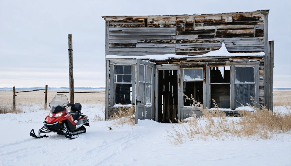
When frozen silence settles over Spokane Ghost Town’s weathered structures, you’ll find yourself standing where 1890s miners once worked their claims—but now it’s your snowshoes breaking trail instead of their pickaxes striking quartz.
The moderate creek trail from Spokane Creek Campground (coordinates N43.840657, W103.376041) leads you through history.
Black Hills National Forest delivers serious winter freedom:
- 416 miles of groomed snowmobile routes across 1.2 million acres
- Carson Draw’s 5-mile loop winds through pine and aspen stands
- Big Hill Trail System offers designated snowshoeing trails where dogs run free
- Deadwood’s 109-mile Mickelson Trail provides gentle terrain for all abilities
- Hell Canyon and Willow Creek routes showcase frozen waterfalls and canyon views
Snowshoeing trails near abandoned settlements let you chase solitude through powder-filled gulches where prospectors once chased fortune.
Scenic Winter Drives Through Ghost Town Country
You’ll find the Peter Norbeck Scenic Byway transforms into a 70-mile winter wonderland as it winds through Custer State Park, connecting you to both the Needles Highway and Iron Mountain Road—your gateway to historic mining settlements.
I’ve navigated these narrow tunnels and sharp curves in January, when granite spires pierce through fresh snowfall and create dramatic backdrops for the abandoned sites dotting the landscape.
Each hairpin turn reveals another breathtaking vista where you can pull over at designated viewpoints to photograph the convergence of natural beauty and forgotten frontier history.
Peter Norbeck Scenic Byway
Winding through the heart of the Black Hills, the Peter Norbeck Scenic Byway transforms into a ghost hunter’s dream route during winter months, when thin crowds and frosted granite spires create an otherworldly backdrop for exploring South Dakota’s abandoned mining heritage.
This 70-mile figure-eight loop connects you to Keystone’s 1880s gold rush remnants while threading through territories rich in Native American history. Mountain lion sightings add wild unpredictability to your journey.
Essential Winter Navigation Details:
- Needles Eye tunnel restricts passage to 8’0″ wide by 9’9″ high vehicles.
- Hairpin curves and pigtail bridges demand slow speeds, extended travel times.
- No restrooms or water sources are available along route.
- Snow conditions require preparation and flexibility.
- Cathedral Spires and granite pinnacles frame your exploration.
You’ll encounter mountain goats traversing frozen cliffs where Norbeck himself once surveyed routes to preserve wilderness access.
Iron Mountain Road Access
Winter road safety here isn’t negotiable.
I’ve watched conditions deteriorate in minutes at these elevations, transforming carved granite passages into whiteout corridors.
Before attempting any winter approach, dial 511 for current conditions.
Pack emergency supplies, verify your tires, and forget cruise control exists.
Those corkscrew bridges that thrill you in summer?
They’ll betray you on black ice.
The 45-minute summer cruise becomes a white-knuckle gamble against rapidly changing mountain weather.
Historic Mining Route Views
The granite spires vanish into December fog along Needles Highway, transforming Governor Peter Norbeck’s mountainside masterpiece into something otherworldly. You’ll navigate tunnels barely wider than your vehicle while ghost town architecture emerges from pine-covered ridges along Route 385.
Winter reveals what summer crowds obscure:
- Galena’s schoolhouse standing sentinel in Vanocker Canyon, mining technology rusting beside snowdrifts
- Rochford’s skeletal structures accessible when ice hardens muddy forest roads
- Mystic’s original buildings framed against white-covered rails where ore once traveled
- Spokane’s whisper-quiet remnants connected by empty Black Hills trails
- Norbeck Overlook panoramas stretching across 68 miles of frozen wilderness
The Spearfish-to-Lead corridor offers paved reliability through ponderosa forests, passing Homestake’s 120-year legacy. Vanocker Canyon provides solitude—fewer tourists means uninterrupted photography of history crumbling beautifully into mountain silence.
Planning Your Ghost Town Adventure
Frost-dusted skeletal buildings pierce South Dakota’s winter horizon like monuments to dreams that couldn’t survive the harsh realities of frontier life.
You’ll need heavy snow boots, insulated gloves, and layers that’ll shield you from biting winds as you trek through these abandoned settlements. Pack your camera—frozen waterfalls and snow-laden ruins create unforgettable shots.
The Mickelson Trail becomes your gateway to Mystic’s pioneer remnants, while Spokane’s crumbling stone walls emerge hauntingly through bare timber.
Winter wildlife tracks crisscross abandoned streets, revealing stories you’d miss in warmer months.
After exploring Deadwood’s accessible landmarks, reward yourself with local dining at historic saloons.
Operating seasons typically run December 15 through March 31, though harsh weather demands flexibility in your plans.
Nearby Winter Activities and Ski Resorts
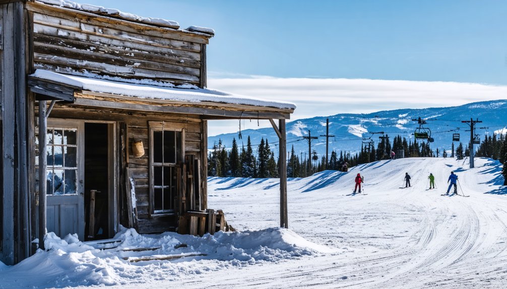
After exploring abandoned settlements and photographing frost-covered ruins, you’ll want to trade your hiking boots for ski boots and experience South Dakota’s winter playground at full speed.
Terry Peak delivers serious terrain with 1,100 feet of vertical from its 7,100-foot summit, while Great Bear welcomes families near Sioux Falls. Both sit minutes from historic mining towns where you’ve been chasing ghosts.
Beyond downhill runs, you’ll discover:
- 350+ miles of groomed snowmobile trails weaving through forests where winter wildlife tracks cross your path
- Nearly 60 miles of cross-country skiing routes past snow-covered cabins in Black Hills National Forest
- Fat biking on George S. Mickelson Trail’s packed powder
- Ice fishing at secluded Deerfield Lake
- Spearfish Canyon’s frozen waterfalls accessible by snowshoe
Free rentals await at Custer State Park—no excuses, just adventure.
Frequently Asked Questions
Are Any Ghost Town Buildings Open for Interior Exploration During Winter?
Capa’s fourteen abandoned buildings offer you genuine indoor tours through decaying houses filled with tattered furnishings and scattered relics. Building accessibility here beats other sites—you’ll explore authentic interiors while most ghost towns restrict you to exterior wandering only.
What Are the Best Photography Hours for Winter Ghost Town Visits?
You’ll capture ideal lighting during the golden hours—sunrise and sunset—when winter photography truly shines. Short daylight positions these magical times at convenient hours, letting you explore ghost towns freely while snow-covered structures glow with dramatic, emotional depth.
Can I Camp Overnight Near These Ghost Towns in Winter Months?
Curiously, you’ll find winter camping options near many ghost towns on National Forest land. You can disperse camp for 14 days, but you’ll need serious safety precautions—no campfires allowed, and water sources freeze solid.
Are Guided Tours Available or Only Self-Guided Exploration Options?
You’ll find both guided tours and self-exploration options available. Deadwood offers professionally guided ghost tours and winter monument excursions, while Spokane ghost town in Custer State Park welcomes your independent discovery along scenic Iron Mountain Road.
Do I Need Special Permits to Visit Ghost Towns on Private Property?
Imagine joyfully trespassing—just kidding! You’ll absolutely need the landowner’s permission before exploring ghost towns on private property. These private property restrictions aren’t optional suggestions. Permit requirements mean obtaining written or verbal consent first, respecting boundaries while pursuing your adventurous freedom.
References
- https://www.deadwoodconnections.com/black-hills-vacation-itineraries/outdoor-enthusiast-winter-itinerary
- https://www.powderhouselodge.com/black-hills-attractions/fun-attractions/ghost-towns-of-western-south-dakota/
- https://www.tripadvisor.com/Attractions-g28962-Activities-c47-t14-South_Dakota.html
- https://www.youtube.com/watch?v=_0WNYsFLSLA
- https://www.blackhillsbadlands.com/blog/post/old-west-legends-mines-ghost-towns-route-reimagined/
- https://blackhillsvisitor.com/see-and-do/winter-activities-in-the-black-hills/
- https://myxoadventures.com/the-ghost-town-of-spokane-south-dakota/
- https://www.travelsouthdakota.com/trip-ideas/abandoned-beauty-ghost-towns-structures-south-dakota
- https://www.historynet.com/ghost-towns-mystic-south-dakota/
- https://www.legendsofamerica.com/mystic-south-dakota/


