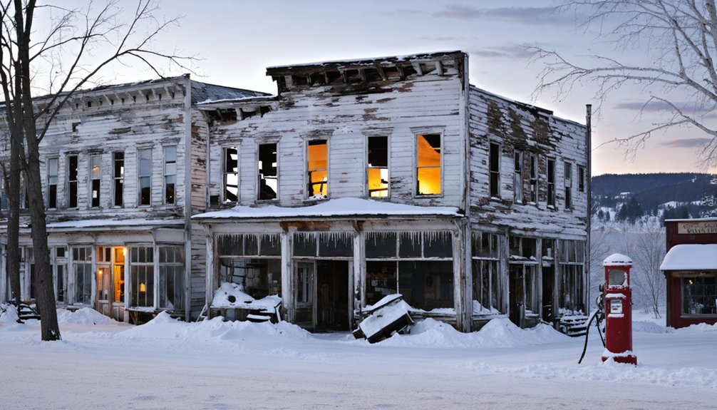
You’ll find Vermont’s most haunting winter ghost towns in the Green Mountains, where Glastenbury’s abandoned settlement holds mysteries of unexplained disappearances, while Somerset’s submerged logging community reveals artifacts along frozen reservoir shorelines. Explore Ricker Basin’s snow-covered cellar holes above Waterbury Reservoir, photograph Greenbank’s Hollow’s 1886 covered bridge amid mill ruins, or venture into Mount Aeolus’s marble cavern where underground ice formations create natural skating rinks. Each site transforms dramatically under winter’s grip, exposing foundations and stone walls invisible during warmer months—though proper preparation determines whether you’ll safely experience these frozen remnants of Vermont’s past.
Key Takeaways
- Glastenbury, abandoned by 1937, offers winter folklore exploration with poorly marked trails through haunted terrain in Vermont’s Green Mountains.
- Somerset’s submerged logging town reveals artifacts like stone piers and ceramic liners along shorelines when winter lowers reservoir water levels.
- Ricker Basin displays 50 families’ abandoned homesteads with visible cellar holes, stone walls, and foundations beneath snow near Waterbury Reservoir.
- Greenbank’s Hollow features an 1886 covered bridge and textile mill ruins with snow-covered foundations accessible from Greenbanks Hollow Road.
- Mount Aeolus near Plymouth Notch offers underground ice skating in a natural marble cavern with frozen waterfalls and frost formations.
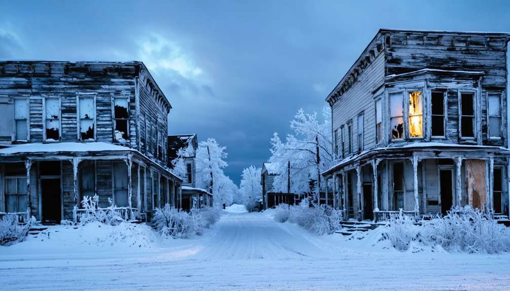
Glastenbury: The Heart of the Bennington Triangle
Deep in Vermont’s Green Mountains, where snow-draped peaks meet ancient forests, lies Glastenbury—a ghost town that once thrived with 241 residents at its 1880 peak.
Beneath Vermont’s snow-crowned peaks, Glastenbury’s abandoned streets whisper tales of 241 souls who once called this wilderness home.
You’ll find yourself standing where charcoal-makers and loggers once carved out lives until the timber ran dry in 1892. The town dissolved entirely by 1937, but its legacy endures through chilling urban legends that emerged from five mysterious disappearances between 1945-1950.
Native Americans considered this mountain sacred yet cursed—a place where four winds clash in eternal battle, warning travelers away except for burials. They spoke of native spirits and a malicious stone that swallows whoever stands upon it.
Winter transforms this haunted landscape into an ethereal domain where you’ll discover why locals call it the heart of the Bennington Triangle. The region’s folklore includes tales of wild men—hairy creatures reported since the 1800s that have become woven into the area’s supernatural mystique. The poorly marked trails leading into this rugged, primitive terrain have caused many hikers to lose their way along the Appalachian Trail’s Long Trail section that cuts through the area.
Somerset: Submerged Logging Heritage Beneath the Reservoir
Beneath the placid surface of Vermont’s largest wild body of water, an entire logging empire lies frozen in time. Somerset Reservoir conceals 41 miles of railroad tracks, fourteen mills, and the skeletal remains of a town that once housed 321 souls.
You’ll discover reservoir artifacts emerging during low water—stone piers, yellow birch poles, and ceramic chimney liners from vanished logging camps that harvested 300 million feet of timber. The power company ended this chapter of human habitation in the 1960s, destroying 13 camps by fire after ceasing all land leases.
Winter transforms this submerged logging graveyard into accessible wilderness:
- Paddle the shoreline where thousands of stumps once jutted above the surface, creating prime fishing hazards
- Explore deteriorating camp ruins along quiet coves, tracing foundations from the 1906 timber baron operations
- Navigate tributaries like Moon Brook under the 10 mph speed limit, discovering where French Canadian and Abenaki loggers once worked
The town was officially disincorporated in 1937, marking the formal end of Somerset’s brief existence as an incorporated community. Plan to spend 1-2 hours exploring this historically significant site, which offers easy access during summer and fall months when weather conditions are most favorable.
Ricker Basin: Hillside Farms Frozen in Time
You’ll discover Ricker Basin’s haunting remains scattered across the hillsides above Waterbury Reservoir.
Where snow-dusted cellar holes and crumbling stone walls mark homesteads that escaped the floodwaters below. Winter transforms these ruins into stark monuments—bare trees frame the foundations, making the settlement’s skeletal layout easier to trace as you hike from one farm site to another.
From the frozen hillside, you’ll gaze down at the ice-covered reservoir that claimed the valley’s roads and riverside homes. The Waterbury Dam’s construction in the 1930s submerged the lower settlement after devastating floods had already driven most families away.
Meanwhile, the upland farms you’re standing in remain perfectly preserved in their abandonment. Joseph Ricker founded the settlement in 1816 as a farm community that eventually grew to around 50 families with the arrival of the railroad.
Cellar Holes and Stone Walls
Scattered across the southeastern slopes of Ricker Mountain, crumbling stone foundations and moss-covered cellar holes tell the story of fifty families who once carved farms from this unforgiving landscape. You’ll discover these abandoned farms threading through Little River State Park, where winter snow reveals the skeletal outline of a vanished community.
Stone walls snake through the forest ruins, marking boundaries that no longer matter—enclosures where sheep once grazed on 4,000 acres of cleared land. The community supported itself through logging and sawmills, taking advantage of abundant timber resources and mountain streams that powered the mills. Small stone walls built from fist-sized stones indicate where settlers once cultivated crops, while larger stones mark former pastureland.
What you’ll find wandering these forgotten homesteads:
- Intact cellar holes where farm families stored root vegetables through brutal Vermont winters
- Miles of hand-stacked stone walls rising from the forest floor, remnants of backbreaking labor clearing rocky soil
- The haunting Ayers homestead site, where a resilient lilac bush still blooms each spring despite a century of abandonment
Winter Hiking Through Remnants
When snow blankets the slopes of Ricker Mountain each winter, the forest transforms into a vast archive of abandoned dreams. You’ll discover trails threading through Green Mountain National Forest and Little River State Park, leading to cellar holes where fifty families once carved existence from unforgiving terrain.
The urban exploration experience intensifies in winter—frozen streams mark former mill sites, stone walls emerge starkly against white hillsides, and ghost town legends materialize in tangible ruins. You can locate the Almeran Goodell farmhouse, Ricker Basin’s sole surviving structure, standing dilapidated yet defiant off-trail.
Winter’s clarity reveals what summer foliage conceals: the complete settlement pattern across 4,000 acres, each foundation a testament to resilience against impossible odds before the 1927 flood delivered its final judgment. The cemetery’s colonial stone walls still mark the community’s boundary, where headstones of Joseph Ricker’s descendants remain mostly intact despite nearly two centuries of exposure.
Reservoir Views From Hillside
The Waterbury Reservoir stretches below the abandoned hillside farms like a mirror of displacement, its frozen winter surface concealing the valley floor where neighbors once gathered.
You’ll stand where Ricker Basin families surveyed their hardscrabble domain, now transformed into this vast water body that claimed their community’s remnants in 1935.
These elevated vantage points reveal why this became prime territory for exploring historical landmarks:
- Almeran Goodell farmhouse ruins perch above the waterline, stone foundations jutting through snow-covered undergrowth
- Stone walls snake across hillsides, mapping boundaries of disappeared homesteads that sheep once grazed
- Little River State Park trails wind past abandoned farmsteads, offering unobstructed winter views across the reservoir’s frozen expanse
You’re witnessing landscape transformation—a drowned valley preserving stories beneath ice while hillside testimony endures above. The settlement once known as Ricker Mills housed about 50 families in the early 1800s, primarily bearing the same last name, before the catastrophic 1927 flood drove residents to their roofs and forever altered this Vermont landscape.
Greenbank’s Hollow: Covered Bridge and Mill Town Ruins
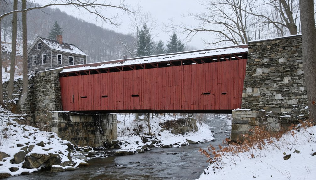
You’ll cross the restored covered bridge spanning Joe’s Creek, where flames once consumed its predecessor during the catastrophic 1885 fire that erased an entire mill town overnight. Snow-dusted granite foundations and cellar holes emerge along the riverbanks, each marked with signs identifying Benjamin Greenbank’s residence, the boarding house, and the post office that served 45 mill workers.
The woolen mill’s stone base still anchors the small falls where water once powered looms that produced 700 yards of cloth daily—now silent ruins offering stark winter photography against ice-rimmed streams.
Historic Covered Bridge Access
Nestled where five rural roads converge in southern Danville, Greenbank’s Hollow Bridge stands as the town’s sole surviving 19th-century covered span—a weathered sentinel guarding the remnants of what was once New England’s largest textile mill.
You’ll reach this 1886 queen post truss structure via Greenbanks Hollow Road off U.S. Route 2, where historic bridge preservation meets accessible exploration.
The Danville Historical Society maintains the site as a public park, offering you:
- Informational plaques detailing the devastating 1885 fire that consumed the original bridge and mill
- Winter photography opportunities beneath the broad eaves and half-height siding
- Structural engineering insights from the 2002 rebuild, including visible steel reinforcements and the reconstructed northern abutment
You’re free to explore this National Register landmark year-round, experiencing authentic Vermont history without crowds or restrictions.
Stone Foundations and Cellars
Beyond the 1886 covered bridge, granite foundations emerge from the forest floor like gravestones for a vanished industrial empire. You’ll discover Benjamin Greenbank’s square residence cellar, the massive woolen mill foundation hugging Joe’s Creek, and boarding house ruins across the stream.
Stone walls meander through snow-draped wilderness, marking boundaries of a settlement that produced 700 yards of cloth daily before the catastrophic 1885 fire sent everything crashing into the water.
Ancient cellar holes beckon exploration along the riverbank, their granite blocks defying a century of abandonment. The Danville Historical Society’s markers guide you through this industrial graveyard where company store, post office, and mill workers’ homes once thrived.
Deep snow can’t hide these stubborn reminders of Vermont’s textile-boom past.
Winter Photography and Safety
When winter sunlight slants through the 1886 covered bridge at Greenbank’s Hollow, photographers discover their golden hour stretching across snow-blanketed ruins and frost-laden timbers.
You’ll find urban decay transformed into natural preservation—where grist mill foundations emerge through fresh powder, and bare hardwoods frame weathered wooden beams without summer’s leafy obstruction.
Your winter expedition requires preparation:
- Wear traction devices on boots for ice-covered trails leading to mill ruins
- Shoot during afternoon hours when limited daylight maximizes your photography window
- Pack emergency supplies since Caledonia County’s mountain weather shifts rapidly
The frozen millstream creates mirror-perfect reflections while snow acts as nature’s diffuser, softening harsh shadows across stone foundations.
Navigate carefully—these remote locations demand respect for winter’s unforgiving conditions alongside your creative vision.
Plymouth Notch: Presidential History in a Mountain Settlement
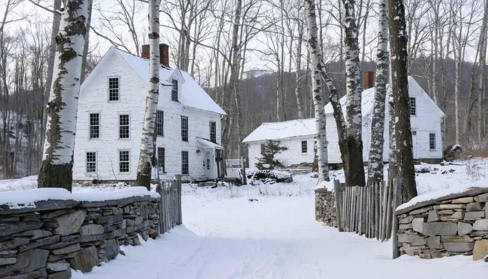
Winter transforms this settlement into something extraordinary. The Aldrich House welcomes you with year-round exhibits, while snow blankets the cemetery where Coolidge rests.
His father’s refusal to modernize preserved original furnishings—you’ll see the family parlor exactly as it appeared that oath night.
This presidential heritage site operates beyond tourist seasons, offering December open houses and February Presidents’ Week events.
You’re free to explore Plymouth Notch‘s roads anytime, experiencing the raw Vermont landscape that shaped America’s thirtieth president.
Dorset Freedlyville Quarry: Winter Ice Caves in Marble Chambers
High on Mount Aeolus’s eastern slope, a 200-by-600-foot cavern penetrates straight into marble bedrock—not downward like typical quarries, but horizontally through the mountain itself.
You’ll discover Vermont’s only subterranean ice skating rink inside this marble cavern, where a partially flooded pond freezes solid and remains frozen until July.
The 2.2-mile round-trip hike rewards you with extraordinary winter features:
- Blue icicles cascading from the 35-foot natural dome like frozen stalactites
- Glass-clear ice you can see straight through while skating
- Colorful marble walls adorned with crystalline frost formations
Since 1808, this quarry’s shipped marble across America, witnessed fatal accidents, and earned haunted whispers.
Today, you’ll find abandoned chambers where temperatures plunge to 19°F and offshoot passageways beckon exploration beyond conventional boundaries.
Preparing for Winter Ghost Town Exploration in Vermont
Exploring Vermont’s frozen ghost towns demands preparation that goes beyond typical winter hiking. You’ll need specialized traction devices like crampons when maneuvering ice-covered structures and frozen terrain where abandoned buildings meet crystallized landscapes.
Snow safety becomes critical near frozen waterways—thin ice over moving water can trap you beneath the surface within seconds.
Cold weather gear must include layered systems protecting against subzero temperatures during extended exploration sessions. Pack ice axes for steep approaches, waterproof boots for crossing snow-laden ruins, and snowshoes for traversing deep powder on old railroad beds.
Since cell service vanishes in remote mountain locations, you’re operating without backup. Understand hypothermia symptoms before venturing out. These forgotten settlements reward the prepared, but they’re unforgiving to those who underestimate winter’s grip on Vermont’s abandoned places.
What to Bring for Safe Cold-Weather Adventures
When temperatures plummet and abandoned settlements vanish beneath Vermont’s snowpack, your survival depends on what’s strapped to your back. Cold weather gear transforms potentially deadly exploration into exhilarating freedom—layer moisture-wicking wool base layers beneath insulating fleece and a waterproof shell.
Your extremities demand equal attention: waterproof boots with 400g insulation, wool socks, and liner gloves under waterproof mittens keep frostbite at bay.
Essential items for backcountry ghost town expeditions:
- Trekking poles with snow baskets for orienting through unstable terrain and frozen cellar holes
- Emergency shelter kit including mylar tarp and bivy for unexpected temperature drops
- Wildlife tracking tools like field guides and cameras to document animal presence in abandoned structures
Pack the Ten Essentials, extra batteries for your headlamp, and traction devices—microspikes conquer icy main streets where settlers once walked.
Frequently Asked Questions
Are Dogs Allowed on Trails to Vermont’s Ghost Town Sites?
Most trails leading to Vermont’s ghost towns welcome your canine companion on dog friendly trails, though you’ll need to follow leash regulations. Check specific forest and park policies beforehand, as requirements vary between Green Mountain National Forest and state parks.
Do Any Ghost Towns Require Entrance Fees or Permits?
You’ll find most ghost towns completely free to explore, though Ricker Basin requires Little River State Park admission. Historical preservation efforts keep these ruins accessible while photography opportunities await—no permits restricting your winter wanderings through Vermont’s abandoned settlements.
What Are the Best Months for Winter Ghost Town Exploration?
December through February offer you prime exploration windows when snow reveals abandoned foundations. You’ll need winter safety tips before venturing out, and historical preservation guidelines guarantee these freedom-filled ruins remain untouched for future wanderers seeking Vermont’s forgotten past.
Are Guided Tours Available for Vermont Ghost Towns in Winter?
Guided ghost town tours aren’t available during Vermont’s winter months, but you’ll discover freedom exploring independently. You can create your own adventure through snowshoeing opportunities while encountering winter wildlife amid abandoned settlements blanketed in pristine snow.
Can You Camp Overnight Near These Abandoned Settlement Sites?
Imagine this: you’re free to explore, but winter camping regulations near Vermont’s abandoned settlements vary by location. You’ll need proper safety equipment essentials and landowner permission. Most ghost town sites sit on private property, requiring advance approval.
References
- https://en.wikipedia.org/wiki/List_of_ghost_towns_in_Vermont
- https://vermontvacation.com/haunted-vt/
- https://happyvermont.com/2014/10/23/glastenbury-ghost-town/
- https://myfamilytravels.com/supposedly-boring-vermont-towns-hiding-some-truly-strange-landmarks
- https://ghost-towns.close-to-me.com/states/vermont/
- https://vermontcountry.com/2022/09/18/ghost-town/
- https://www.youtube.com/watch?v=PjJJxmwnJ3o
- https://www.vftt.org/threads/does-anyone-know-of-any-hikes-that-include-a-ghost-town.16760/
- https://sharonahill.com/triangle-trope-of-vermont-bennington/
- https://husheduphistory.com/post/752239038412603392/mystery-and-missing-the-tragic-trails-of-the


