Alabama’s reservoirs conceal complete communities submerged for hydroelectric development. You’ll find Easonville beneath Logan Martin Lake, flooded in the 1960s after displacing 60 families with minimal compensation. Lake Martin submerged Kowaliga in 1926, erasing a thriving Black settlement founded in 1890 with its own academic institute. Smith Lake’s 1961 flooding destroyed Clear Creek Falls—an 80-foot waterfall—along with farms, churches, and graveyards. These underwater ghost towns contain building foundations, railroad beds, relocated cemeteries, and cultural landmarks that document systematic displacement. The structures below reveal stories of resistance, inadequate restitution, and communities deliberately erased.
Key Takeaways
- Easonville was submerged in the late 1960s by Logan Martin Dam, displacing 60 families with inadequate compensation and destroying homes, farmland, and churches.
- Kowaliga, a thriving African-American community founded in 1890, was flooded by Martin Dam in 1926, erasing its educational and cultural institutions.
- Smith Lake’s 1961 creation submerged Clear Creek Falls, an 80-foot waterfall, along with farms, gravesites, churches, and entire Black communities.
- Underwater remnants include building foundations, railroad beds, roads, and grave sites visible beneath Smith Lake and other Alabama reservoirs.
- A 50,000-70,000-year-old bald cypress forest lies submerged off Gulf Shores, temporarily exposed after Hurricane Ivan in 2004.
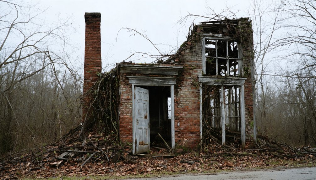
The Disappearance of Easonville in the 1960s
The Logan Martin Dam project initiated by Alabama Power in the early 1960s permanently erased Easonville, a rural community situated one mile from the Coosa River in St. Clair County.
You’ll find that approximately 60 families faced forced property acquisitions, receiving compensation insufficient for reconstruction—one 100-acre farm owner’s payment exemplifies this inadequacy.
The systematic destruction proceeded methodically: crews burned houses and trees, creating illuminated night scenes, while submerged cemeteries required exhumation and relocation following newspaper notices.
Residents moved structures to higher ground in 1963, some selling properties for $6,000 before relocating to Pell City.
Water levels rose incrementally, ultimately submerging the entire town by the late 1960s.
This hydroelectric project eliminated underwater agriculture, homes, and the community church, transforming productive farmland into what’s now a tourist lake. The displacement occurred during a period of limited environmental protections, enabling corporate acquisition at bargain prices with minimal accountability. The town had been settled by farmers from the mid-1800s and previously thrived with three stores and churches before its submersion.
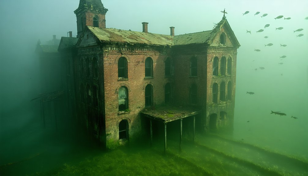
Kowaliga: A Pioneering Black Community Lost to Lake Martin
Born into slavery along Kowaliga Creek’s shores in the 1850s, John Benson established what would become one of Alabama’s most significant Black-owned communities following his emancipation.
From bondage to landowner, John Benson forged a path toward Black prosperity and autonomy in post-emancipation Alabama.
Using $100 earned from Shelby County coal mines, he purchased 160 acres in 1890, expanding to 3,000 acres with industrial infrastructure powered by creek water. John Benson worked in the Cahaba Field coal mines, earning less than half a dollar per ton of coal before saving enough to purchase his former owner’s land.
His son William transformed the settlement into an educational center, establishing Kowaliga Academic and Industrial Institute with Booker T. Washington’s board participation. William also organized the Dixie Industrial Company in 1900, operating over 10,000 acres and employing around 300 workers from both Black and white communities.
However, Alabama Power Company’s 1926 Martin Dam flooded this thriving community:
- 500 students lost their educational institution
- Decades of cultural heritage submerged permanently
- Archaeological significance now lies beneath Lake Martin’s waters
- Economic independence destroyed by rising floodwaters
Today’s vacation paradise conceals the underwater ruins of Black self-determination and achievement.
Forced Relocations and the Human Cost of Progress
When Alabama Power Company proposed Smith Lake’s construction in 1954, residents confronted a stark choice: accept compensation for their property or lose it through eminent domain. The ecological impact devastated Clear Creek Falls, Alabama’s largest waterfall, alongside fertile farmland and forest ecosystems.
You’ll find evidence of cultural loss in the 60 Easonville families forced to relocate during the 1960s dam project. Documented accounts describe burning houses and trees, graves relocated through newspaper notices, and churches physically moved to higher ground.
Water rose incrementally over four years, submerging not just structures but family histories. The 1980s Chandler Mountain reservoir proposal triggered coordinated resistance—residents leveraged political channels and obtained suppressed archaeological reports proving historical sites would be destroyed, successfully defending their land rights.
The lake was expected to take five years to fill, but heavy rainfall in 1958 caused it to reach capacity within just 11 months, transforming the landscape far sooner than displaced residents had anticipated. The Lake Martin community, a historically African-American community, was partially submerged during the creation of Martin Dam, erasing another chapter of Alabama’s settlement history.
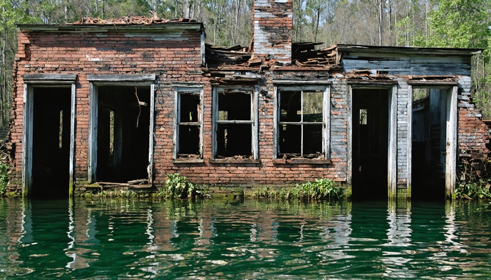
What Lies Beneath: Submerged Structures and Lost Landmarks
Beneath Alabama’s reservoir surfaces, you’ll find concrete evidence of pre-flooding civilization: railroad beds extending uselessly into deep water, submerged building foundations, and abandoned vehicles marking former settlement boundaries.
The infrastructure creates genuine navigational hazards for modern boaters, particularly near dam structures where urban legends of giant catfish intersect with actual submerged constructs at Smith Lake. Flooding caused evacuations and permanent displacement of entire communities, leaving behind structural remnants now hidden beneath the water’s surface.
Natural landmarks also disappeared permanently—Clear Creek Falls, once among Alabama’s largest waterfalls, now exists only in historical records after lake creation erased this geological feature from the landscape.
Hidden Infrastructure and Hazards
Alabama’s reservoirs conceal extensive infrastructure networks that transform familiar waterways into hazardous navigation zones. Submerged railroad beds near Trimble create shallow corridors where depths shift suddenly from navigable to dangerously deep. Dam structures spawn myths about underwater caves harboring massive catfish, though the real threat lies in deteriorating construction materials scattered across lake floors.
These hidden dangers threaten your freedom to safely navigate Alabama’s waters:
- Abandoned railroad infrastructure creates invisible barriers where water shifts from 3 feet to 30 feet without warning
- Submerged buildings and equipment from 60 displaced families form navigation obstacles beneath Smith Lake
- Decaying construction materials from the phantom Northern Beltline project contaminate waterways with rusting metal and crumbling concrete
- Forest clearing debris remains entangled with trees, barns, and vehicles lost during Logan Martin Lake’s creation
The state’s aging municipal water systems compound these aquatic hazards, with communities like Prichard losing 60% of water through deteriorating underground pipes that destabilize surrounding soil and drainage networks. This infrastructure collapse not only burdens residents with astronomical bills but creates unseen voids beneath streets and waterways where old pipes have failed after 80 years of neglect. Meanwhile, the Northern Beltline consumed over 163 million dollars to build just 1.3 miles of roadway before abandonment in 2022, leaving behind construction debris and environmental damage across stream crossings.
Lost Natural Wonders
The construction of hydroelectric dams between 1926 and 1960 permanently erased significant geological features from Alabama’s landscape, with Clear Creek Falls representing the most substantial loss. You’ll find this waterfall—once among Alabama’s largest—now lies beneath Smith Lake’s surface, eliminated when Alabama Power flooded the valley in 1954.
The submersion fundamentally altered ecosystem changes across the region, transforming flowing river habitats into static reservoir environments. Pre-dam topography included dramatic elevation changes that disappeared as water levels rose, making mountains appear lower according to construction-era correspondence.
Water quality shifted from creek-fed systems to managed reservoir conditions. You can’t access these geological formations anymore—they’re buried under hydroelectric infrastructure that prioritized power generation over natural preservation, demonstrating how development decisions irreversibly modify landscapes.
Clear Creek Falls and Other Natural Wonders Gone Forever
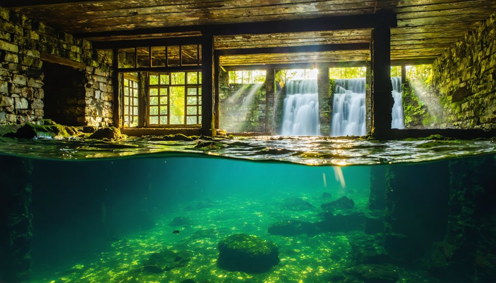
When Lewis Smith Dam’s reservoir filled in 1961, Clear Creek Falls—featuring upper and lower cascades of 43 and 37 feet respectively—disappeared beneath 100 feet of water.
You can now detect the submerged formation only through depth finders, which register a 45-foot drop when crossing the site.
This permanent loss occurred without archaeological documentation, as federal historic preservation requirements wouldn’t take effect until 1966, five years after inundation.
The falls had been discovered by Jesse Livingston in November 1812, who later built a grist mill at the site and established one of the area’s early frontier settlements.
Clear Creek Falls Submerged
Among Alabama’s most significant natural losses to dam construction, Clear Creek Falls stood as an 80-foot double waterfall system that vanished beneath Smith Lake’s waters in 1961.
When Alabama Power completed the 300-foot Lewis Smith Dam, waterfall archaeology became impossible—the cascades now rest 100 feet below the reservoir surface.
You’ll find nothing remains of this landmark where Chickasaw gathered for centuries. The falls’ submersion destroyed irreplaceable creek ecosystems supporting mountain laurel, Alabama azalea, and Eastern hemlock.
What was sacrificed:
- Upper falls plunging 43 feet over sandstone ledges
- Lower cascade dropping 37 feet into Clear Creek
- Historic grist mill site from 1828
- Natural habitat serving as navigational landmark since pre-colonial times
Conservationists Herbert McCullough and Blanche Dean opposed the dam, but bureaucratic power prevailed over preservation.
Lost Natural Features Below
Dam construction destroyed Clear Creek Falls, but Alabama’s underwater natural heritage extends far beyond reservoir bottoms. Eight miles off Gulf Shores, you’ll find a 50,000-70,000-year-old bald cypress forest at 60 feet depth—exposed when Hurricane Ivan’s 90-foot waves scoured sediment in 2004.
This half-square-mile site represents extraordinary fossil preservation: oxygen-free burial kept cypress sap fresh for millennia. Marine archaeology teams documented the discovery in 2012, with 2019 expeditions collecting samples through zero-visibility conditions.
The trees grew when sea levels sat 400 feet lower during ice age conditions. Now they support artificial reef ecosystems—fish shelter in stumps while crustaceans colonize ancient roots.
Chemical analyses confirm these southeastern swamp species serve as climate change time capsules, demonstrating nature’s power to preserve evidence authorities can’t erase.
The Fight Against Chandler Mountain Dam in the 1980s
Although Alabama Power had successfully constructed multiple dams across the state throughout the mid-20th century, the company’s 1980s proposal for a pumped storage hydropower facility on Chandler Mountain encountered unprecedented resistance.
You’ll find this wasn’t just about economic development versus environmental conservation—it was about communities refusing to surrender their homeland.
The proposed project threatened to destroy:
- Ancestral lands where generations had built their lives and legacy
- Critical habitat for endangered Canoe Creek clubshell and trispot darter
- Pristine Big Canoe Creek watershed through hydrological degradation
- Archaeological sites containing irreplaceable cultural artifacts
Residents organized through Save Chandler Mountain, partnering with Coosa Riverkeeper and Southern Environmental Law Center.
Their unified resistance forced Alabama Power’s withdrawal in August 2023, proving that determined citizens can protect their freedom against corporate encroachment.
Preserving the Stories of Underwater Ghost Towns
Beneath Smith Lake’s surface lies a railroad bed that never carried trains—a submerged remnant of the Queen of Austria coal mine operation that locals now use as a navigation marker. You’ll find oral histories document what floodplain ecology studies cannot: the precise locations of Clear Creek Falls, submerged farmsteads, and relocated gravesites.
Dennis Richard’s accounts and Susan Robinson Eller’s descriptions provide cartographic data for underwater topography. At Lake Martin, William Benson’s Kowaliga Academic and Industrial Institute disappeared in 1926 when Martin Dam gates closed, transforming a thriving post-Civil War settlement into vacation property.
Water quality monitoring equipment now passes over John Benson’s community legacy. These testimonies preserve archaeological records that remain inaccessible—documenting structures, cultural sites, and communities that hydroelectric development erased from Alabama’s physical landscape.
The Erasure of Black Communities Through Dam Construction
- Churches where generations worshiped, submerged or hastily relocated.
- Burial sites of ancestors moved after mere newspaper notices.
- Educational institutions like Kowaliga’s prestigious academy erased entirely.
- Homes and trees deliberately burned, creating apocalyptic scenes before flooding.
You’ll notice minimal compensation patterns: some families received fractions of property value, others nothing.
Without environmental laws requiring public input, power companies exploited legal frameworks that denied Black landowners meaningful recourse or resistance.
Frequently Asked Questions
Can Scuba Divers Legally Explore the Submerged Ghost Town Structures?
You’ll likely find no explicit laws prohibiting exploration of Alabama’s submerged structures. However, diving safety regulations require proper certification, and underwater archaeology concerns mean you should verify Alabama Power’s current lake management policies before accessing these 264-foot-deep sites.
Were Residents Fairly Compensated When Forced to Relocate for Dam Construction?
Records don’t document fair compensation for displaced residents. You’ll find relocation difficulties were widespread, with compensation disparities evident—particularly affecting Kowaliga’s Black community. Power companies prioritized project completion over equitable treatment, leaving families with minimal recourse or negotiating power.
How Many Total Alabama Communities Were Submerged by Dam Projects?
You’ll find documented evidence of five Alabama communities submerged by dam projects: Easonville, Kowaliga, Greensport, Bainbridge, and Prairie Bluff. However, aquatic archaeology in these lake ecosystems suggests additional undocumented settlements likely exist beneath reservoir waters.
Exploration of the history of Aigleville, Alabama, reveals that many of its past inhabitants may have left behind remnants that could further our understanding of regional development. As researchers delve into submerged landscapes, they may uncover artifacts that tell the stories of once-thriving communities. The implications of these findings could reshape our understanding of the cultural and historical evolution of Alabama as a whole.
Are There Maps Showing Exact Locations of Underwater Towns and Structures?
Maps pinpoint land-based ghost towns with coordinates, but you’ll find underwater sites lack precise charting. Historical preservation efforts haven’t documented submerged structures’ exact positions, though archaeological significance remains noted through proximity markers like rivers and former ferry crossings.
Could Any Submerged Communities Be Recovered if Water Levels Dropped Permanently?
Recovery would face severe preservation challenges from 60+ years of structural decay, sedimentation, and water damage. You’d encounter significant environmental impact from draining reservoirs, making restoration economically and ecologically unfeasible despite community interest in reclaiming history.
References
- https://soul-grown.com/the-haunting-history-behind-the-creation-of-alabamas-smith-lake/
- https://www.wwno.org/news/2023-10-31/place-erased-how-a-drowned-alabama-town-still-holds-lessons-60-years-later
- https://www.youtube.com/watch?v=dDkvfD2APWA
- https://www.youtube.com/watch?v=l3D4hSQcWbk
- https://en.wikipedia.org/wiki/List_of_ghost_towns_in_Alabama
- https://www.wunc.org/2024-01-18/the-broadside-transcript-place-erased-environmental-ghost-towns
- https://wbhm.org/2023/place-erased-a-look-at-gulf-south-communities-transformed-by-forces-beyond-their-control/
- https://lakelife247magazine.com/remembering-easonville/
- https://yellowhammernews.com/the-forgotten-history-of-kowaliga-the-town-beneath-lake-martin/
- https://www.ontheshoulders1.com/the-giants/how-this-black-town-was-wiped-off-the-map