You’ll find Arizona’s primary underwater ghost town at Lake Alamo, where Alamo Crossing—a manganese mining settlement founded in the 1890s—has been submerged under 80 feet of water since 1968. The federally-constructed earth-filled dam flooded the entire town, preserving post offices, mills, and residential structures beneath the surface. Advanced Open Water certification is required to dive the site, where you’ll encounter intact adobe walls, industrial equipment, and streets now covered in mollusks. This thorough guide explores the town’s full history, diving requirements, and what archaeological features await exploration.
Key Takeaways
- Alamo Crossing, a manganese mining town founded in the 1890s, was submerged in 1968 beneath Lake Alamo after dam construction.
- The Alamo Dam, built for flood control, created a reservoir exceeding one million acre-feet, submerging the original settlement completely.
- Submerged structures include adobe walls, brick smelters, post offices, and mills preserved up to 80 feet underwater.
- Advanced Open Water certification is required for diving due to depths reaching 80 feet and challenging visibility conditions.
- Lake Mead also contains submerged Arizona sites, including the Old Waddell Dam buried beneath 80 feet of water.
Alamo Crossing: Arizona’s Submerged Mining Town
In the late 1890s, Tom Rogers established Alamo Crossing as a modest mining outpost along the Bill Williams River, where transient prospectors sought their fortunes in the shadow of the Artillery Mountains.
You’ll find this settlement’s coordinates at 34.2605, -113.5827, elevation 1,237 feet. The infrastructure included a five-stamp mill, stores, and a post office operating intermittently from 1889-1918.
Population peaked at merely 18 residents by 1960. When Alamo Lake formed in 1968 behind a 283-foot earthfill dam, the town submerged intact beneath 80 feet of water. The Army Corps of Engineers constructed this earth-filled dam along the Bill Williams River.
Today, you’d need scuba gear to explore structures alongside ancient artifacts and preserved desert flora. The site sits approximately three hours northwest of Phoenix, making it an accessible destination for adventurous divers. Recent 2020 exploration by Power Metal Resources yielded three gold nuggets, reviving interest in this accessible ghost town.
The History Behind Lake Alamo’s Creation
You’ll find Alamo Crossing’s origins traced to mining operations that preceded the area’s transformation into a reservoir.
The Army Corps of Engineers contracted dam construction in 1968 along the Bill Williams River, creating a 283-foot earthfill structure composed of layered rock and sand.
This project served the Flood Control Act of 1944‘s mandate to protect the Lower Colorado River from Bill Williams River drainage while establishing water storage capacity.
The Corps also developed recreational facilities including a campground, picnic area, beach, restrooms, and boat ramp to support public access to the reservoir.
The lake features two main access points, with the south side offering more developed amenities and the north side providing a rugged wilderness experience.
Alamo Crossing’s Mining Origins
Tom Rodgers established Alamo Crossing in the late 1890s as a temporary encampment for miners working the Artillery Mountains’ mineral deposits in Mohave County.
You’ll find this settlement’s mining history centered on manganese extraction, with prospecting legends documenting its evolution from a transient camp at 1,237 feet elevation along the Bill Williams River.
The operation included a five-stamp mill, several stores, and a post office that functioned intermittently between 1889 and 1918.
Located 60 miles northwest of Wickenburg, it served independent prospectors seeking mineral wealth.
The Rodgers brothers maintained multiple claims through 1928, with the first manganese shipments departing around that year.
The 1950s brought renewed activity when manganese demand surged, though post-1954 decline led to abandonment before Lake Alamo‘s waters eventually claimed the site. The settlement’s story has been preserved through Loquis podcast documentation, which explores the geographic and cultural significance of this Mohave County location.
1968 Dam Construction
Following decades of flooding concerns along the Bill Williams River, Congress authorized the Alamo Dam project through the Flood Control Act of 1944 (Public Law 78-534), after the Chief of Engineers recommended its approval.
This multi-purpose project addressed flood control, water storage, and public recreation—though initial hydro-power plans proved unfeasible.
Construction challenges defined the eight-million-dollar undertaking. Engineers built an earth-filled dam rising 283 feet from the riverbed, with a 975-foot crest reaching elevation 1,265 feet.
Located 39 miles upstream from Lake Havasu, the structure created a million acre-feet reservoir. Like the Colorado River’s 1905 break that transformed the Salton Sink region, uncontrolled flooding had historically threatened the surrounding valleys before the dam’s construction.
Work continued through the mid-1960s, culminating in 1968 completion. The reservoir stretched from the damsite to three miles above Alamo Crossing—permanently submerging the settlement beneath Arizona’s newest lake. The dam received flows from the Big Sandy and Santa Maria rivers, which converge upstream to form the Bill Williams River.
Flood Control Purpose
The Flood Control Act of 1944 authorized Alamo Dam after the Chief of Engineers identified a critical need to protect the Lower Colorado River from flood threats originating in the Bill Williams River drainage system.
You’ll find this infrastructure specifically addresses flooding from the Big Sandy and Santa Maria rivers, which converge into the Bill Williams watershed. The dam’s flood control mechanism stores incoming floodwaters while releasing them under controlled conditions during severe events—giving downstream communities predictable protection rather than catastrophic uncertainty.
However, this engineering solution created significant environmental impact. The altered flow patterns devastated downstream woodland habitats along the Bill Williams River, causing substantial forest loss through both drought storage and irregular flood releases. The Army Corps of Engineers completed the dam construction in 1944, transforming the landscape into what would eventually become a recreational destination. The dam’s creation also resulted in a man-made lake surrounded by low desert vegetation and Sonoran Desertscrub plant communities in west central Arizona.
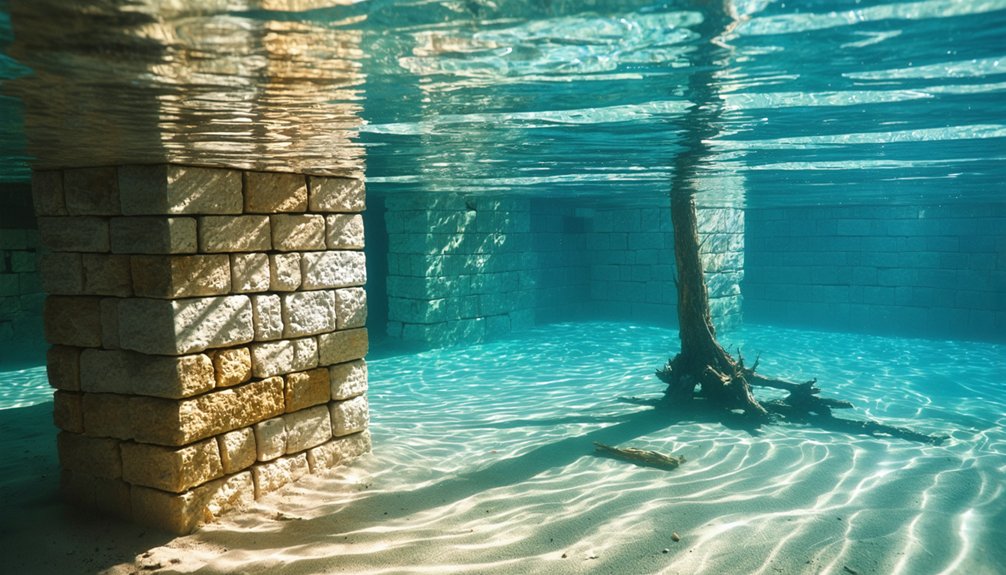
What Lies 80 Feet Below the Surface
At 80 feet below Lake Alamo’s surface, the abandoned mining settlement remains structurally intact with its post office, mill, and shops preserved in cold water.
The original town road extends directly into the reservoir, creating a visible pathway that descends from shore to the submerged structures.
You’ll need scuba certification and equipment rated for depths up to 24 meters to access the site, where deterioration progresses slowly in the lake’s anaerobic conditions. Before diving, review regulations and lake conditions to ensure safe exploration of the underwater site.
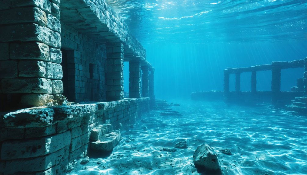
Preserved Mining Town Structures
Beneath 80 feet of reservoir water, Ruby’s mining infrastructure remains remarkably intact, with more than two dozen buildings still maintaining their roofs decades after submersion. The sturdy jail stands alongside collapsed commercial structures, while the school building persists as teacherages disintegrated into scattered lumber.
Mining techniques employed during Ruby’s operational years required extensive support facilities—you’ll find mill foundations, mine offices, officials’ residences, and miners’ dormitories positioned strategically on the southern hillside.
Town architecture throughout Arizona’s ghost towns followed practical patterns: adobe walls at Harshaw’s James Finley House, brick smelter structures at Swansea, and gray-plastered quarters for workers. Montana Camp’s development after the 1870s quartz discoveries established systematic layouts that maximized ore processing efficiency.
the history of chaparral ghost towns reveals how resource extraction influenced settlement patterns. Each town’s rise and fall often mirrored the boom and bust cycles of mining industries across the region. As these communities transformed or disappeared, remnants of their architectural styles remained, telling stories of the past and the people who once called them home.
These submerged structures document precise construction methods designed for permanent industrial operations.
Road Leading Underwater
When Lake Mead reaches full capacity, Old Waddell Dam rests approximately 80 feet beneath the surface, its previous concrete structure remaining intact despite replacement by the current earth dam.
You’ll need boat-based diving expeditions to access this submerged infrastructure, where maximum depths reach 260 feet.
Ancient riverbeds now form natural ravines that drop 80 feet, creating submerged pathways marked by boat wreckage and rock debris accumulation. These geological features serve as navigation landmarks for locating multiple vehicle wrecks—including a bus at 50 feet and van at 35 feet near Katherine Landing.
Water clarity varies with lake level fluctuations and sediment disturbance. Consult Arizona Game & Fish data before planning your expedition, as accessibility changes with current conditions.
Scuba Access Requirements
Alamo Crossing’s submerged structures rest at a maximum depth of 80 feet (24 meters) below Alamo Lake’s surface, where the 1968 earthfill dam construction permanently flooded this manganese mining settlement from the late 1890s.
You’ll need proper certification and scuba gear to explore these preserved remains.
Essential access requirements:
- Advanced Open Water certification – The 80-foot depth demands training in nitrogen narcosis management and deep diving protocols through PADI or equivalent programs.
- Buddy diving protocol – You’re required to dive with a partner when exploring the ghost town’s intact structures, including the post office, mill, and stores.
- Equipment standards – Your scuba gear must meet safety guidelines for recreational depth limits, with no permit necessary from the Army Corps of Engineers.
Shore access eliminates boat requirements, giving you direct entry freedom.
Scuba Diving Through a Preserved Wild West Settlement
At depths between 35-40 meters in Arizona’s reservoir systems, technical divers locate frontier-era settlements submerged during dam construction projects. You’ll discover the Perrera family village through mixed gas diving protocols, with bottom times restricted to 5-10 minutes due to depth constraints.
Marine archaeology documentation reveals well-preserved stone walls, rooftops, and silent streets frozen in time. A small statue remains tucked within the Pereira house’s stone wall—likely positioned by the settlement’s final resident.
You’ll face technical challenges: freezing temperatures below 30 meters, near-zero visibility, and minimal light penetration. Underwater ecosystems now claim these historic structures.
Your dive requires constant monitoring of time, depth, temperature, and visibility parameters while collecting evidence. These submerged communities preserve authentic Wild West history beyond government-regulated surface exhibitions.
St. Thomas: Nevada’s Ghost Town That Rose Again
Unlike the permanently submerged Arizona settlements accessible only through technical diving, St. Thomas offers you direct access to a ghost town that’s defied submersion. Founded by Mormon settlers in 1865, this Nevada site disappeared beneath Lake Mead’s waters in 1938 following Hoover Dam’s construction.
Drought conditions have now exposed its concrete foundations.
You’ll find evidence of remarkable cultural heritage spanning millennia:
- Pueblo Grande de Nevada (AD 300) – Lost City ruins with ancient artifacts from Basketmaker cultures
- Mormon settlement remains (1865-1938) – foundations, streets, building remnants
- Protected archaeological sites – ongoing research documenting 10,000 years of human habitation
The National Park Service maintains a 2.5-mile loop trail at Stewart’s Point (36°27′57″N 114°22′13″W).
Visit Overton’s Lost City Museum to examine rescued artifacts before Lake Mead’s levels rise again.
Comparing Arizona’s Flooded Towns to Lake Mead’s Lost Community
Lake Mead’s submerged landscapes divide into two distinct categories of underwater heritage sites. You’ll find Arizona’s industrial concrete plants represent pure infrastructure—mixing facilities, railroad systems, and 125-foot tunnels with mollusk-covered machinery tied directly to Hoover Dam construction. These sites remain perpetually submerged, accessible only through technical diving operations.
St. Thomas contrasts sharply as Nevada’s complete residential community. You’re examining a Mormon settlement with grocery stores, service stations, and an ice cream parlor—structures reflecting authentic frontier life from 1865.
Its archaeological significance emerges through periodic exposure since 2004, enabling cultural preservation efforts you can’t achieve with Arizona’s underwater industrial ruins.
Your understanding of eminent domain‘s impact differs dramatically: St. Thomas received minimal compensation before 1938 abandonment, while Arizona sites were simply discarded post-construction.
Other Desert Ghost Towns Near the Underwater Sites
These sites remain accessible year-round, offering unrestricted exploration opportunities for independent research and documentation.
Planning Your Visit to Lake Alamo State Park
Before beginning your expedition to Lake Alamo State Park, you’ll need to account for the site’s remote location approximately 70 miles northwest of Phoenix off Highway 93.
Access routes include Highway 60 from the south, positioning you 2.5 hours from Phoenix’s constraints.
Seasonal weather dictates ideal visit windows. Summer daylight temperatures exceed 100°F, while November and April offer 80°F days with 40°F nights.
Spring rains trigger wildflower emergence across the sparse desert terrain.
Wildlife migration patterns bring bald eagles, golden eagles, and waterfowl during cooler months.
You’ll observe resident populations of foxes, coyotes, mule deer, and wild burros year-round.
The park enforces a 14-day maximum stay, with 2 p.m. check-in and noon checkout.
Modern facilities include restrooms, dump stations, and newly constructed cabins for extended exploration.
Frequently Asked Questions
Are There Human Remains or Graves Submerged With Alamo Crossing?
No documented evidence confirms human remains or graves submerged at Alamo Crossing. You’ll find the town’s underwater preservation protects building structures, but its small, transient population and 1960s evacuation left no archaeological significance regarding burials at this site.
Can You Legally Remove Artifacts From the Underwater Ghost Town?
No, you can’t legally remove artifacts from Alamo Lake’s submerged town. Arizona State Park regulations and preservation laws prohibit artifact theft from historical sites. Federal protections under ARPA enforce strict penalties, protecting your access through responsible exploration practices.
What Water Temperature Should Divers Expect at 80 Feet Depth?
At 80 feet depth, you’ll encounter temperatures near 47°F year-round, below the 30-foot thermocline. Temperature fluctuations remain minimal at this depth, affecting marine ecology and requiring proper thermal protection for safe, unrestricted exploration.
Were Any Residents Still Living There When the Dam Flooded It?
No residents remained when Arizona’s dam flooded these sites. You’ll find they’d been abandoned decades earlier, leaving only ruins for underwater exploration. Historic preservation efforts now document these ghost towns through methodical archaeological surveys of submerged structures.
Could Drought Conditions Eventually Expose Alamo Crossing Like St. Thomas?
Yes, prolonged drought could expose Alamo Crossing like St. Thomas emerged from Lake Mead. You’d witness historical preservation challenges as receding waters reveal structures after 50+ years submerged, though conservation efforts would face significant documentation and protection obstacles.
References
- https://www.onlyinyourstate.com/experiences/arizona/underwater-ghost-town-az
- https://en.wikipedia.org/wiki/Alamo_Crossing
- https://www.youtube.com/watch?v=eKMSVZZ2ZQ0
- https://justalittlefurther.com/just-a-little-further/2023/2/26/st-thomas-lake-meads-ghost-town-uncovered
- https://www.stagecoachtrailsranch.com/2017/10/01/alamo-lake-lost-submerged-ghost-town/
- https://www.destination4x4.com/alamo-crossing-mohave-county-ghost-town/
- https://kids.kiddle.co/Alamo_Crossing
- https://www.loquis.com/en/loquis/6595590/Alamo+Crossing+Arizona
- https://azstateparks.com/alamo-lake/explore/park-history
- https://azstateparks.com/alamo-lake/explore/science-and-history


