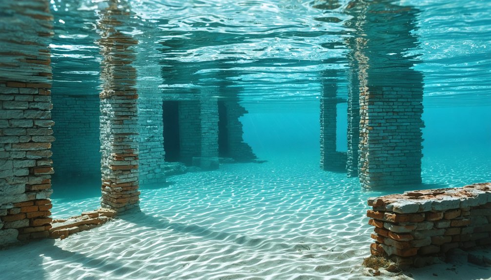
You’ll find several ghost towns submerged beneath Desert Southwest reservoirs, most especially St. Thomas, Nevada, which disappeared under Lake Mead in 1938 following Hoover Dam‘s completion. The settlement, founded by Mormon pioneers in 1865, now rests 50-70 feet below the surface alongside other flooded communities like Pueblo Grande de Nevada and Texas’s Bluffton. Severe drought conditions since 2002 have progressively exposed adobe foundations, cisterns, and skeletal infrastructure, transforming these sites into accessible archaeological landscapes that reveal the systematic displacement of communities driven by mid-20th century water management projects.
Key Takeaways
- Multiple towns in the Desert Southwest were intentionally flooded during 1930s dam construction, including St. Thomas, Nevada and Bluffton, Texas.
- St. Thomas was submerged under Lake Mead in 1938 after Hoover Dam completion, displacing residents with minimal compensation through eminent domain.
- Severe droughts periodically lower reservoir levels, exposing foundations, adobe walls, and artifacts from submerged communities for archaeological study and public viewing.
- Sites are managed by the National Park Service within Lake Mead National Recreation Area, with protected ruins accessible during low water periods.
- Submerged settlements include ancient sites like Pueblo Grande de Nevada and 19th-century towns, serving as evidence of systematic infrastructure-driven displacement.
The Rise and Fall of St. Thomas, Nevada
When Mormon settlers established St. Thomas in 1865 under Brigham Young’s directive, they couldn’t foresee their town’s underwater fate.
You’ll find Thomas S. Smith among the dozen original founders who divided 600 acres into five-acre parchs near the Muddy and Virgin Rivers’ confluence.
Thomas S. Smith led a dozen pioneers in parceling 600 acres into homesteads where two mighty rivers converged in the desert.
The settlement peaked at 500 residents, developing infrastructure including schools, hotels, and a railroad spur along the Arrowhead Trail.
However, Nevada’s gold-tax demands triggered the 1871 LDS exodus, though the town experienced resurgence in the 1880s.
The federal government’s 1930s acquisition preceded submersion beneath 50-70 feet of Lake Mead water.
Residents protested the government’s land valuations, as federal assessments fell short of local estimates, leading to unresolved compensation disputes into the 1940s.
Hugh Lord, the last resident, rowed away from his house on June 11, 1938, marking the town’s final chapter.
Today’s drought-exposed ruins provide invaluable historical archaeology opportunities, while cultural preservation efforts continue through National Park Service trails and the relocated cemetery’s interpretive programming.
How Hoover Dam Changed the Landscape Forever
Although planners initially considered Boulder Canyon, geologic faults and insufficient width forced engineers to relocate construction to Black Canyon, where they’d build what became the world’s tallest dam upon its 1936 completion.
The concrete arch-gravity structure fundamentally altered regional hydrology, creating Lake Mead—America’s largest reservoir by volume—while eliminating the Colorado River’s natural flood cycles.
This landscape transformation enabled controlled water distribution for agriculture and urban centers, supporting millions of acres of irrigated farmland beyond natural rainfall capacity.
However, the dam triggered severe ecosystem disruption: the Colorado River Delta received zero flow for six years, creating an inverse estuary with elevated salinity levels.
Native fish species including bonytail chub, Colorado pikeminnow, humpback chub, and razorback sucker faced population collapse as sediment transport, water quality, and flood-dependent habitats disappeared.
The dam’s construction brought together thousands of workers from across the nation during the Great Depression, symbolizing collective effort in one of America’s most challenging economic periods.
Before construction could begin, engineers diverted the Colorado River through four massive tunnels—two on each side of the canyon—each roughly 56 feet in diameter and totaling nearly three miles in combined length.
Seven Decades Beneath Lake Mead
Following Lake Mead’s complete filling by 1938, St. Thomas remained submerged for approximately seven decades as water levels stabilized at capacity after Hoover Dam’s completion.
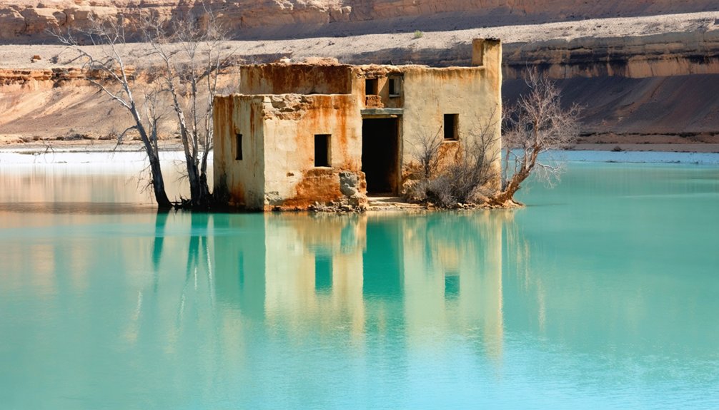
The town’s infrastructure—including adobe structures, foundations, and the 60-foot ice cream parlor chimney—deteriorated under hydrostatic pressure and sediment accumulation throughout this extended submersion period.
Beginning in 2002, sustained drought conditions reduced reservoir levels sufficiently to expose the settlement’s archaeological remains, transforming what you’d recognize as a static lake bed into a fluctuating zone of intermittent emergence.
The exposed townsite has hosted commemorative reunions in 1945, 1965, and 2012, where former residents and their descendants gathered to reminisce about the community that once thrived in this now-barren landscape.
Today, only foundations of the original town remain visible, with the National Park Service installing informational signs to help visitors understand the layout of structures like the grocery store, schoolhouse, and general store.
Complete Submersion by 1940s
As Hoover Dam construction progressed through the mid-1930s, the impounded Colorado River began transforming the Moapa Valley into what would become Lake Mead, North America’s largest reservoir by volume.
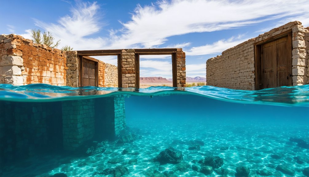
You’ll find St. Thomas succumbed to complete inundation by June 25, 1938, when rising waters forced final resident Hugh Lord to row away from his burning homestead. The reservoir ultimately submerged the settlement beneath 60 feet of water, erasing surface evidence except cottonwood treetops temporarily marking the site.
Federal acquisition facilitated this engineered flooding, sacrificing historical preservation for flood control and hydroelectric generation. The submersion encompassed four miles of railroad infrastructure and isolated highway sections. Water levels rose to obscure two miles of highway sections, further cutting off access to the abandoned townsite. Efforts to relocate structures and graves to higher ground preceded the flooding, though some remains became permanently submerged.
For 64 years, underwater exploration remained the sole method to document this desert community’s architectural remnants and spatial configuration beneath the expanding reservoir.
Drought Reveals Lost Foundations
Severe drought conditions across the Colorado River Basin initiated Lake Mead’s recession in the early 21st century, exposing St. Thomas’s foundations after seven decades of submersion. The town resurfaced in 2002, remaining continuously visible since 2003 as water levels declined to historic lows.
You’ll find adobe walls, cisterns, and building foundations scattered across the site, where urban decay mingles with water erosion patterns etched into remaining structures. The ice cream parlor‘s chimney—once submerged 60 feet below the surface—now stands as the highest point among accessible roads and trails. Visitors reach the ruins via a 2.5-mile hike from an unpaved road, with no shade available along the exposed desert trail.
Walking Through St. Thomas Today
Due to prolonged drought conditions reducing Lake Mead‘s water levels to historic lows, St. Thomas has emerged from its watery grave.
You’ll find the National Park Service maintains an accessible trail through the remnants within Lake Mead National Recreation Area. Modern preservation efforts protect these exposed foundations while archaeologists conduct ongoing research.
You’re free to walk streets lined with skeletal cottonwood remnants, exploring visible foundations of homes and commercial buildings sixty feet below the former high-water mark. The Hannig Ice Cream Parlour chimney remains the tallest structure standing among the ruins.
The relocated cemetery now rests in Overton, where an interpretive center displays archaeological discoveries from the site. These ruins offer tangible evidence of Mormon settlement patterns and early twentieth-century infrastructure, providing unfiltered access to southwestern colonization history without bureaucratic restrictions.
Bluffton, Texas: A Colorado River Community Lost to Progress
While Mormon settlers were establishing St. Thomas, pioneer Billy Davis claimed Colorado River territory in 1852, founding what would become Bluffton, Texas. You’ll find this settlement thrived until New Deal hydroelectric ambitions intervened.
Bluffton flourished for eight decades before federal dam projects transformed the thriving Texas settlement into an underwater ghost town.
The Lower Colorado River Authority acquired land through forced sales at minimal compensation, displacing approximately 50 families when Buchanan Dam‘s completion in 1937 submerged the community.
Archaeological preservation efforts documented structures including a cotton gin, bank, and hotel now resting 20-30 feet underwater. Cultural heritage suffered as residents relocated 300 graves—58 remaining unidentified—to New Bluffton, seven miles west.
The Texas Historical Commission’s archaeological division conducts excavations during drought conditions, when receding waters expose tombstones and foundations.
This submersion represents government authority overriding individual property rights for collective infrastructure development.
The Lost City of Pueblo Grande De Nevada
The Colorado River system claimed another archaeological treasure when Lake Mead submerged Pueblo Grande de Nevada, a sixteen-mile complex of prehistoric settlements along the Muddy River terrace near Overton, Nevada.
You’ll find evidence of continuous occupation from 300 A.D., including pit-houses, pueblos, and prehistoric salt mines that facilitated ancient trade networks across the Southwest.
When Hoover Dam’s authorization in 1928 threatened the site, archaeologists raced against rising waters to document this western-most Ancestral Puebloan settlement.
Mark Harrington coordinated emergency excavations with the Civilian Conservation Corps, achieving vital artifact preservation before submersion in the late 1930s.
Today’s drought has reexposed these ruins since 2012, allowing researchers to employ drones and 3D imaging while the Lost City Museum houses recovered materials for your examination.
More Drowned Communities Across the Region
Beyond Pueblo Grande de Nevada, systematic reservoir development throughout the Colorado River Basin and adjacent watersheds has submerged numerous settlements between 1930 and 1970.
You’ll find Bluffton, Texas disappeared beneath Lake Buchanan in 1937, its 50 families relocated before flooding consumed their Colorado River community.
Old Kernville, California vanished under Lake Isabella, though drought conditions now expose its wild western structures and ancient artifacts from the Gold Country era.
St Thomas, Nevada remained submerged 70 feet below Lake Mead since 1935 until persistent drought revealed its foundations in 2002.
These engineered floods transformed productive settlements into archaeological sites.
While no underground tunnels connected these communities, their remnants now serve as stark evidence of systematic displacement—concrete testimony to how centralized water management projects permanently altered regional settlement patterns.
Why Desert Towns Ended Up Underwater
Massive federal dam construction projects during the mid-twentieth century systematically flooded established communities throughout the American Southwest as part of coordinated water management infrastructure development.
Government agencies exercised eminent domain to acquire properties, offering compensation that residents couldn’t refuse.
You’ll find these projects destroyed:
- St. Thomas (1935) – Hoover Dam created Lake Mead, submerging 60 feet deep
- Mormon Island (1955) – Folsom Dam formed reservoir over gold rush settlement
- Whiskey Flat (1960s) – Lake Isabella covered dynamited structures
- Fairdale (1969) – Toledo Bend buried communities 110 feet underwater
Climate change now exposes these sites during droughts, revealing ancient artifacts and foundations.
Federal authorities prioritized centralized water control over individual property rights, permanently displacing populations without consent for infrastructure deemed essential to regional development.
Frequently Asked Questions
Can You Scuba Dive to Explore the Submerged Ruins When Water Levels Rise?
Historically, you could’ve explored these sites when water depths reached 70 feet, but you’ll find diving impractical now. Underwater navigation and diving safety become moot points since drought conditions have exposed these ruins for terrestrial access.
What Artifacts Have Been Recovered From These Underwater Ghost Towns?
You’ll find everyday dishes, tools, bullet casings, and building remnants with archaeological significance recovered from sites like St. Thomas. However, historic preservation protocols require most artifacts remain in situ, cataloged for research rather than removed.
Are There Other Submerged Towns Expected to Reemerge as Droughts Worsen?
Yes, you’ll likely see more submerged towns reemerge as Colorado River Basin droughts intensify. Historical preservation opportunities increase alongside concerning ecological impacts from fluctuating reservoir levels, exposing infrastructure and contaminating sediments across vulnerable southwestern waterways.
How Do Authorities Protect These Sites From Vandalism and Looting?
How do you safeguard submerged heritage sites? Authorities employ legal protections under archaeological resource laws and implement preservation techniques including site monitoring, restricted access zones, and law enforcement patrols, though enforcement remains challenging across vast reservoir expanses.
Were Residents Compensated When Their Towns Were Flooded for Dam Projects?
You’ll find compensation varied considerably across projects. St. Thomas residents received Bureau of Reclamation payments, though relocation challenges persisted. However, compensation disputes were common, with abandoned towns like Alamo Crossing receiving nothing, highlighting inconsistent federal acquisition policies.
References
- https://mikesroadtrip.com/st-thomas-nevada/
- https://www.youtube.com/watch?v=QNEIN5aixdA
- https://www.mapquest.com/travel/underwater-ghost-town/
- https://www.youtube.com/watch?v=JnIIQymTY3w
- https://clui.org/newsletter/spring-2005/immersed-remains-towns-submerged-america
- https://texashighways.com/culture/history/the-lost-underwater-towns-of-texas/
- https://www.nps.gov/lake/learn/nature/st-thomas-nevada.htm
- https://travelnevada.com/ghost-town/st-thomas-ghost-town/
- https://en.wikipedia.org/wiki/St._Thomas
- https://ensignpeakfoundation.org/st-thomas-nevada/


