
You’ll find at least 14 submerged communities beneath Kansas’s major reservoirs, deliberately flooded between 1952 and 1980 during federal dam construction. Following the catastrophic 1951 flood that killed 24 people and caused $935 million in damages, projects like Tuttle Creek Dam, Milford Lake, and Clinton Lake required extensive land acquisition and forced demolition of towns including Randolph, Garrison, Stockdale, and Chelsea. These ghost towns—now underwater landmarks marked by remnants like cemetery islands and intake towers—represent significant landscape modification and community displacement that museums and memorials continue documenting.
Key Takeaways
- At least 14 Kansas towns were submerged by flood control reservoirs including Tuttle Creek, Milford, and Clinton Lakes after devastating floods.
- Tuttle Creek Dam (1959) flooded communities like Randolph, Stockdale, and Garrison, leaving only cemetery monuments and intake towers visible.
- Milford Lake, Kansas’s largest reservoir, submerged towns including Alida and Broughton when filled in 1967 after 1962-1966 construction.
- Chelsea, a former county seat founded in 1857, now lies underwater beneath El Dorado Lake with only its cemetery remaining.
- Columbia disappeared entirely by 1858 due to flooding and Bleeding Kansas violence, leaving no archaeological traces beneath the Cottonwood River.
The 1951 Flood That Changed Kansas Forever
When torrential rains began falling across the Kansas River basin in June 1951, few residents anticipated the catastrophic flooding that would soon reshape their state’s landscape and infrastructure policy.
Between July 9-13, rainfall totals reached 8-16 inches, with some areas recording nearly 19 inches throughout the month.
In just five days, parts of Kansas received nearly 19 inches of rain—more than most areas see in months.
The deluge exceeded historical benchmarks from 1844 and 1903, creating unprecedented conditions that exposed critical failures in flood preparedness.
By July 13, the Kansas River crested 4-6 feet above previous records at stations from Manhattan to Bonner Springs.
Downtown Manhattan was submerged under 8 feet of water, while Topeka evacuated 24,000 residents.
The disaster claimed lives, including Dr. Charles F. Wiest and his daughter, who perished when their home caved in during the flooding.
The catastrophe ultimately killed 24 people and displaced thousands across the most affected river basins.
Total damages exceeded $935 million in 1951 dollars—equivalent to $11.3 billion today—forcing fundamental reconsideration of urban development policies near vulnerable waterways.
Milford Lake: Where 14 Communities Disappeared
Following the devastating 1951 flood, Congress authorized Milford Lake through the Flood Control Act of 1954, initiating a transformation that would erase 14 communities from Kansas’s physical and social landscape.
You’ll find that the Army Corps of Engineers constructed the dam from 1962-1966, with impoundment beginning January 16, 1967.
Towns like Alida and Broughton ceased to exist entirely, while Wakefield and Milford relocated to higher ground.
Despite fierce opposition from residents who understood flood control benefited downstream cities at their expense, defeat was inevitable.
The dam’s construction cost approximately $49.7 million, creating what would become the largest man-made lake in Kansas.
The lake reached its normal level six months after filling began, transforming thousands of acres into a permanent reservoir.
Archaeological discoveries preceded submersion, including the 1967 investigation of the Bogan Site, which revealed a village destroyed by fire with protective palisades.
Eighty-one artifacts were recovered, preserving fragments of history before water permanently claimed these communities.
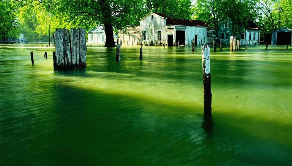
Tuttle Creek Dam and the Towns Left Behind
The Kansas River Valley’s catastrophic flood history, spanning from 1844 Kanza and Osage village devastation through successive disasters in 1903 and 1935, culminated in the July 13, 1951 “Black Friday” event that fundamentally altered the region’s approach to water management.
That flood submerged Manhattan’s business district under eight feet of water, caused $935 million in damage, killed 28 people, and displaced 518,000 residents.
Eight feet of water, $935 million in damage, 28 dead, and over half a million displaced in a single catastrophic day.
The floodwaters proved so powerful they forced the tributary Blue River to run backward.
You’ll find the U.S. Army Corps of Engineers’ response—Tuttle Creek Dam construction beginning in 1952—permanently erased ten communities from Kansas maps.
Four towns disappeared entirely: Cleburne, Randolph, Garrison Cross, and Stockdale.
The project displaced 3,000 residents who’d faced both historical droughts and river erosion.
The dam’s closure on July 4, 1959 diverted the Big Blue River’s flow through massive intake towers known as “The Tubes.”
Garrison’s Carnahan cemetery remains the sole physical *testament* to these vanished settlements, located 15 miles west of Westmoreland.
Clinton Lake’s Buried Villages
Clinton Lake’s construction required the complete demolition of nine rural communities across Douglas and Shawnee Counties, including the towns of Belvoir, Bloomington, Sigel, and Richland.
The Army Corps of Engineers forced thousands of farmers to sell their land beginning in the mid-1960s, with all buildings in the flood zone razed before the reservoir’s 1980 filling.
Displaced residents formed the Clinton Lake Landowner’s Association and filed unsuccessful petitions against what they called the “damn dam,” protesting the government’s destruction of their communities and livelihoods.
The project was authorized by the Flood Control Act of 1962, which aimed to prevent the devastating floods that had repeatedly struck the Wakarusa Valley.
The lake began holding water in 1977 and took three years to reach its full capacity, permanently submerging the farmland and communities beneath its surface.
Towns Lost to Waters
When the U.S. Army Corps of Engineers dammed the Wakarusa River in 1975, you witnessed the permanent disappearance of established communities. The reservoir’s environmental impact fundamentally altered Douglas and Shawnee Counties’ landscape, creating what some characterize as controlled urban decay through governmental flood control priorities.
The submerged settlements included:
- Belvoir, Bloomington, and Sigel in Douglas County—completely flooded communities
- Richland in Shawnee County—entirely underwater
- Thousands of farmland acres—productive agricultural zones inundated
- Nine rural communities total—displacing homes, churches, cemeteries, and multigenerational farms
Construction authorized by the Flood Control Act of 1962 began in 1972. Reservoir filling commenced November 1977, reaching normal levels by 1980. Clinton Dam followed over 20 dams constructed across Kansas by the U.S. Army Corps of Engineers and the Bureau of Reclamation since the first dam at Kanopolis was completed in 1948.
You’ll find Clinton Lake now provides water for over 100,000 residents—purchased through community sacrifice. The Corps promoted the project as multifaceted, emphasizing flood control, recreation, wildlife conservation, and water supply benefits to justify the displacement.
Residents’ Protests and Relocation
Forced land sales began in the mid-1960s during planning stages, creating immediate friction between federal authorities and Wakarusa River Valley property owners.
You’ll find that real estate transactions proved contradictory and contentious, with federal appraisers offering prices like $200 per acre—approximately $108,000 for an 80-acre farm with home.
The Clinton Lake Landowner’s Association organized resistance through protests and petitions against the Corps of Engineers, though unsuccessful.
This urban development project demolished four towns: Belvoir, Bloomington, Sigil, and Richland, submerging thousands of acres beneath water.
The environmental impact extended beyond physical displacement—residents called it the “damn dam” while watching homes bulldozed into excavated pits. You’d understand their bitterness: forced relocation threatened regional identity while federal authorities dismissed flood control concerns as justification.
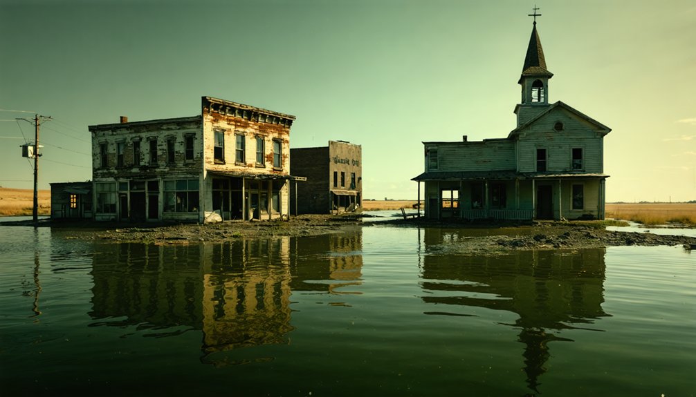
Chelsea: El Dorado Lake’s Lost Settlement
In August 1857, settlers established Chelsea in Butler County’s fertile Walnut River valley as a deliberate rival to El Dorado, naming it after Chelsea near Boston following a compromise from the original “Boston” proposal by founder Pegleg Morton. The settlement achieved remarkable firsts for Butler County, becoming the initial county seat in 1859.
You’ll find Chelsea’s historic architecture now lies beneath El Dorado Lake, which flooded the town in 1978 after 133 years of community stories.
Chelsea’s trajectory illustrates frontier competition:
- 1859-1867: Served as county seat until losing popular vote to El Dorado
- 1867-1915: Failed railroad petitions and bypassed oil boom accelerated decline
- 1970s: El Dorado Lake Project initiated dam reconstruction
- 1978: Complete submersion ended settlement; only Chelsea Cemetery survived on protected dike
Columbia’s Brief Existence Along the Cottonwood River
Columbia’s settlement began in 1855 near the Cottonwood River crossing, but its existence proved remarkably short-lived.
On September 14, 1856, an abolitionist attack led by John E. Cook resulted in looting of stores and the death of Sarah Van Gundy Carver.
This event prompted 78 families to abandon the area.
The Cottonwood River’s persistent southward migration through flooding ultimately erased the remaining physical traces of the townsite.
Historians noting this have observed that nothing remained by 1858.
1855 Settlement and Location
Where exactly did Columbia stand along the Cottonwood River? You’ll find pinpointing this cultural heritage site challenging due to the river’s dynamic nature and water management impacts.
Historical records reveal conflicting placement:
- 1856 maps mistakenly positioned Columbia at the Cottonwood-Neosho confluence, the actual site of Neosho Rapids.
- 1874 Lyon County plat maps show the river in dramatically different positions compared to earlier surveys.
- The shifting Cottonwood River course has obscured the exact townsite location over time.
- Columbia Bridge (formerly Columbia ford) sat south of the original settlement, with the Willis claim’s 80 acres spanning both riverbanks.
Settlers arrived in May 1855, with Charles Johnson, James H. Pheanis, David Vangundy, and John Rosenquist establishing homesteads near the Neosho junction.
1856 Abolitionist Attack
The settlement’s establishment in 1855 coincided with Kansas Territory’s violent descent into sectional warfare over slavery. You’ll find historical significance in the region’s proximity to Franklin County, where John Brown’s abolitionist band executed five pro-slavery settlers near Pottawatomie Creek on May 24-25, 1856.
This retaliation for Lawrence’s sacking ignited Bleeding Kansas’s bloodiest phase, claiming 29 lives over three months. The Kansas-Nebraska Act of 1854 had sparked this conflict by allowing popular sovereignty on slavery, triggering armed migrations from both sides.
While preservation efforts now focus on documenting submerged territorial settlements, they can’t erase the violence that shaped them. Brown’s tactical strikes demonstrated how frontier communities became battlegrounds where ideological commitments superseded legal frameworks, fundamentally altering Kansas’s path toward statehood.
River Floods Erase Town
Along the Cottonwood River’s precarious banks, Madison County’s earliest documented settlement emerged as a modest cluster of log structures that would barely survive a decade.
Columbia’s physical remnants vanished completely by 1858, victims of the Cottonwood’s volatile flooding patterns that resisted any primitive flood management efforts.
The site’s erasure followed a predictable pattern:
- Uneasy existence among Breckenridge residents prevented sustainable growth beyond four or five buildings
- River dynamics obliterated all structures, leaving zero evidence for historical preservation
- 1868 land claims by William and Jane Willis encompassed the abandoned 80-acre townsite
- Current aerial surveys reveal only empty fields north of the old river channel’s tree line
You’ll find nothing remains—no archaeological fragments, no structural foundations, just ghost town documentation proving Columbia’s brief, flood-erased existence.
Kanopolis and the Dawn of Dam Construction
During the mid-1800s, California’s Gold Rush and the Homestead Act propelled westward expansion through Kansas’s Smoky Hill River valley, transforming sparse prairie into a contested corridor of settlement.
Fort Harker’s 1864 establishment marked federal commitment to protecting these routes, attracting figures like Custer and Buffalo Bill. However, the valley’s 1-3 mile wide flood plain exposed settlers to catastrophic risks.
The devastating 1938 flood—which had previously relocated Ellsworth in 1867—catalyzed congressional authorization for Kanopolis Dam in 1940. U.S. Army Corps of Engineers initiated construction that year, suspended operations during World War II, then resumed in 1946.
Remembering the Submerged: Museums and Memorials
While Kanopolis Dam‘s construction introduced engineered flood control to Kansas, subsequent reservoir projects displaced entire communities across the state’s river valleys. You’ll find evidence of these sacrificed settlements preserved through dedicated memorial efforts challenging federal water rights decisions.
The SubMerged exhibition documented this displacement through:
- 14 towns moved, razed, or abandoned for Milford (1962-1966) and Tuttle Creek dam projects
- Arabia Steamboat Museum artifacts demonstrating Missouri River’s historical navigation dangers near Kansas City
- Chapman Center archives preserving forgotten histories of displaced communities
- Cultural preservation initiatives partnering with Smithsonian’s Water/Ways exhibition
These institutions guarantee you can access documented testimonies from residents who witnessed inevitable federal encroachment. Planning maps displayed in post offices foretold submersion, while today’s museums transform collective loss into educational resources examining water’s impact on regional autonomy.
Frequently Asked Questions
Can Scuba Divers Explore the Ruins of Submerged Towns in Kansas Lakes?
You’ll find scuba diving restricted at Kansas’s submerged town sites due to preservation priorities and Corps of Engineers regulations. While you’re free to explore designated recreational areas, you must prioritize scuba safety techniques and respect underwater wildlife habitats instead.
Were Residents Compensated When Their Towns Were Taken for Dam Projects?
You’d think they could’ve just Venmo’d residents, but compensation practices involved lengthy legal disputes. The government acquired farmland through court-ordered right-of-entry proceedings starting in 1952, compelling landowners to accept payment and evacuate despite widespread opposition.
Are There Any Original Buildings Still Standing From the Relocated Towns?
You won’t find original buildings standing in relocated areas—historical architecture was entirely demolished before flooding. Preservation efforts failed as landowners’ opposition couldn’t stop government seizure, leaving only photographs documenting your communities’ lost heritage beneath Tuttle Creek’s waters.
How Deep Underwater Are the Former Town Sites in These Reservoirs?
Like sediment gradually filling a bathtub, environmental impact has reduced Tuttle Creek’s depths from 30 feet to shallower levels, obscuring historical preservation of submerged towns. You’ll find precise measurements unavailable, as variable reservoir operations constantly shift water depths.
Were Cemeteries Relocated Before the Towns Were Flooded or Submerged?
You’ll find no documented evidence of cemetery relocations for Kansas’s submerged towns. This absence creates historic preservation concerns and relocation controversies, as standard Corps of Engineers protocols typically required grave transfers before flooding—yet records remain silent.
The history of Oxford, Kansas reveals a rich tapestry of community resilience and adaptation in the face of natural calamities. As families faced the prospect of losing their homes, the town’s residents banded together to preserve their shared memories and continue their legacies. Understanding the town’s past is crucial for ensuring that its story is not forgotten amidst the waters that have changed its landscape.
References
- https://cedarbayoumarina.com/four-ghost-towns-under-lake-texoma/
- https://dianastaresinicdeane.wordpress.com/2012/01/29/columbia-a-kansas-ghost-town-story/
- https://www.humanitieskansas.org/get-involved/kansas-stories/nature/dont-forget-broughton
- https://lawrencebusinessmagazine.com/2021/07/15/history-washed-away-and-a-personal-account/
- https://www.kcur.org/arts-life/2022-04-09/ghost-towns-are-all-around-kansas-city-if-you-know-where-to-look
- https://lostkansas.ccrsdigitalprojects.com/sites/lostkansas/files/private_static/2022-12/LT_BU_Chelsea_Morris.pdf
- https://krex.k-state.edu/bitstreams/4060a302-7d4a-41fa-a162-36b65bc4292a/download
- https://www.youtube.com/watch?v=u3JmiUHeZa8
- https://en.wikipedia.org/wiki/Great_Flood_of_1951
- https://www.weather.gov/top/1951_flood


