You’ll find significant submerged archaeological sites beneath Kentucky’s reservoir systems, particularly Kentucky Lake, where Birmingham—a Tennessee River port of 900+ residents—was systematically dismantled during TVA’s 1938-1944 Kentucky Dam construction. The town’s foundations, street grids, and infrastructure remain preserved underwater at Birmingham Point (36°54′47″N 88°11′53″W), becoming visible during seasonal drawdowns. Cave Run Lake similarly conceals Yale, a dismantled lumber town submerged in the 1970s. These displacement projects created documented underwater heritage sites where foundations, cemeteries, and structural remnants provide tangible archaeological evidence of forced community relocations and TVA’s transformative regional impact.
Key Takeaways
- Birmingham and Yale are Kentucky’s primary submerged ghost towns, displaced by TVA dam construction creating Kentucky Lake and Cave Run Lake.
- Birmingham was abandoned in the early 1940s when Kentucky Dam flooded the area, submerging homes, streets, and businesses beneath Kentucky Lake.
- Yale, a lumber town, was dismantled in 1913 and later submerged in the 1970s following Cave Run Lake’s construction.
- During low water levels, visible remnants include foundations, streets, cemeteries, and structural debris at sites like Birmingham Point and Cemetery Island.
- Underwater archaeology reveals artifacts including waterworks foundations, sandstone blocks, and mill remains through sonar surveys and direct exploration.
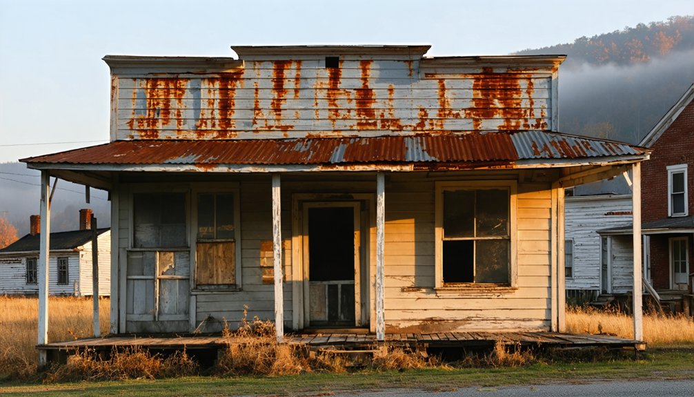
Birmingham: A Thriving Community Lost to Progress
When Thomas Grubbs platted Birmingham on his Marshall County property in 1853, he established what would become one of Kentucky’s most prosperous riverside settlements before the Tennessee Valley Authority‘s dam construction program permanently altered the region’s geography.
You’ll find Birmingham incorporated in 1860, strategically positioned along Tennessee River banks as a critical shipping hub. The settlement’s infrastructure supported over 900 residents by the 1920s, featuring two schools, five churches, and diverse commercial establishments processing poultry, timber, and mussel products. The community also boasted America’s first baseball team in Marshall County, adding to its cultural significance in the region.
TVA’s 1938 relocation notice preceded systematic land acquisition beginning in 1942. Kentucky Dam‘s 1944 completion submerged the community beneath Kentucky Lake’s waters. The construction project also created Lake Barkley, causing further displacement in the region.
Today, urban decay manifests underwater—foundations and streets emerge during low water levels, offering tangible cultural artifacts from this once-thriving economic center.
The Dark Chapter of Racial Violence in Birmingham
While Birmingham, Kentucky’s underwater ruins represent physical displacement, Birmingham, Alabama’s historical record documents systematic racial violence and oppression that defined the city’s identity through the mid-20th century.
You’ll find this city earned recognition as America’s most segregated, where legal frameworks institutionalized community displacement through:
- Convict labor systems and vagrancy laws explicitly targeting African-Americans
- Redlining practices denying mortgages and economic resources to black neighborhoods
- Coordinated bombing campaigns (1947-1965) destroying homes and churches in designated areas
Commissioner Eugene “Bull” Connor’s 1963 deployment of fire hoses and attack dogs against nonviolent protesters—including children—produced documented evidence of state-sanctioned racial violence. The Birmingham Campaign of 1963, initiated by the Southern Christian Leadership Conference, mobilized marches, sit-ins, and boycotts to confront this brutal segregation directly.
Between 1947-1965, fifty bombings transformed communities into zones of terror. This systematic oppression created displacement as profound as any physical inundation, erasing neighborhoods through violence rather than water. Black workers’ incomes remained less than half of white wages, as discriminatory employment practices locked African-Americans into lower-paying, unskilled positions while excluding them entirely from roles as police officers, firefighters, or retail clerks.
Tennessee Valley Authority and the Kentucky Dam Project
The Tennessee Valley Authority emerged from President Franklin D. Roosevelt’s New Deal in 1933, mandating flood control, hydroelectric generation, and navigation improvements across the Tennessee River watershed.
You’ll find Congress authorized the Kentucky Dam project on May 23, 1938, responding to the devastating 1937 Ohio River flood. Construction began July 1, 1938, near Gilbertsville, employing over 5,000 workers during six years of development.
The $118 million project—TVA’s most expensive—created engineering innovations including pioneering ground freeze stabilization and extensive aerial photography applications. Completed August 30, 1944, this historical architecture spans 8,422 feet, impounding 160,000-acre Kentucky Lake. The dam stands 206 feet in height, with more than half submerged below the water’s surface.
The economic impacts proved substantial: year-round navigation connected regional commerce to national waterways, while power generation supported industrial growth. Kentucky Dam represented the last and largest dam constructed on the Tennessee River.
However, development necessitated relocating entire communities, highways, and rail infrastructure beneath rising waters.
The Submersion of Birmingham Beneath Kentucky Lake
Birmingham’s pre-TVA infrastructure supported several hundred residents through timber mills, stave production, and mercantile establishments spanning two hotels, five churches, and multiple commercial operations by the early 1940s.
Kentucky Dam’s impoundment permanently submerged the town’s physical structures under Kentucky Lake, forcing complete population displacement and abandonment of all buildings to rising waters.
You’ll observe exposed building foundations and street layouts at Birmingham Point during periods of significant lake drawdown, providing archaeological evidence of the settlement’s original footprint.
The town’s establishment in 1849 as a timber and stave mill community preceded its submersion by nearly a century, creating layers of history now preserved beneath the lake’s surface.
Birmingham was named after Birmingham, England, reflecting aspirations tied to iron production and industrial development that characterized the region’s economic ambitions during the mid-nineteenth century.
Community Life Before TVA
Before Kentucky Dam transformed the Tennessee River valley into an expansive reservoir, Birmingham functioned as a compact but essential commercial node along the river’s banks in Marshall County. You’d have found approximately 400 residents sustaining themselves through river-dependent commerce until the early 1940s.
The community’s infrastructure supported autonomous local governance:
- Churches and educational facilities serving generational continuity
- Commercial establishments facilitating trade networks
- Ferry connections enabling unrestricted regional mobility
Kentucky Highway 58’s 1933 commission enhanced connectivity to Eddyville via river crossing.
The Tennessee River sustained transportation monopoly until railroad construction in 1890 diversified logistics options. However, TVA’s dam planning following the 1937 flood initiated inevitable urban decay.
Rather than experiencing gradual economic decline, Birmingham faced systematic abandonment—residents departed completely before impoundment, leaving no relocated settlement. The town vanished beneath Kentucky Lake’s engineered waters by 1944. Kentucky Dam’s construction, spanning from July 1, 1938 to August 30, 1944, required the displacement of communities including Birmingham to create the 160,300-acre reservoir. In March 1961, TVA lowered the lake 12 feet below normal summer pool to create flood control space, temporarily exposing Birmingham’s remnants after approximately 17 years of submersion.
Visible Remnants Today
When Kentucky Dam’s impoundment operations commenced in 1944, hydraulic pressure systematically submerged Birmingham’s infrastructure beneath what became Kentucky Lake’s engineered reservoir.
You’ll find structural remnants emerging during winter pool drawdowns when water levels drop several feet below normal elevation. Birmingham Point provides suitable observation coordinates for examining exposed foundations and street grids.
The murky sediment-laden water obscures underwater photography attempts, though boat tours departing from Land Between the Lakes can position you above documented structure locations.
“Cemetery Island” appears seasonally, marking burial grounds that survived inundation.
You’re free to explore via kayak, hiking trails, or fishing expeditions along accessible shorelines.
These periodic exposures reveal tangible evidence of TVA’s 1938 relocation mandate, transforming occupied settlement into subaquatic archaeological site within Kentucky’s engineered waterscape system.
What Remains: Exploring Birmingham Point Today

- Foundation perimeters indicating mill and mercantile structures
- Cemetery island preserving graves at 36°54′47″N 88°11′53″W
- Debris fields containing structural fragments
Access requires watercraft or overland navigation through challenging terrain. The site’s exposure periods coincide with winter pool conditions, creating limited temporal windows for investigation. No regulatory signage exists, and exploration remains subject to lake-level variability rather than bureaucratic restriction.
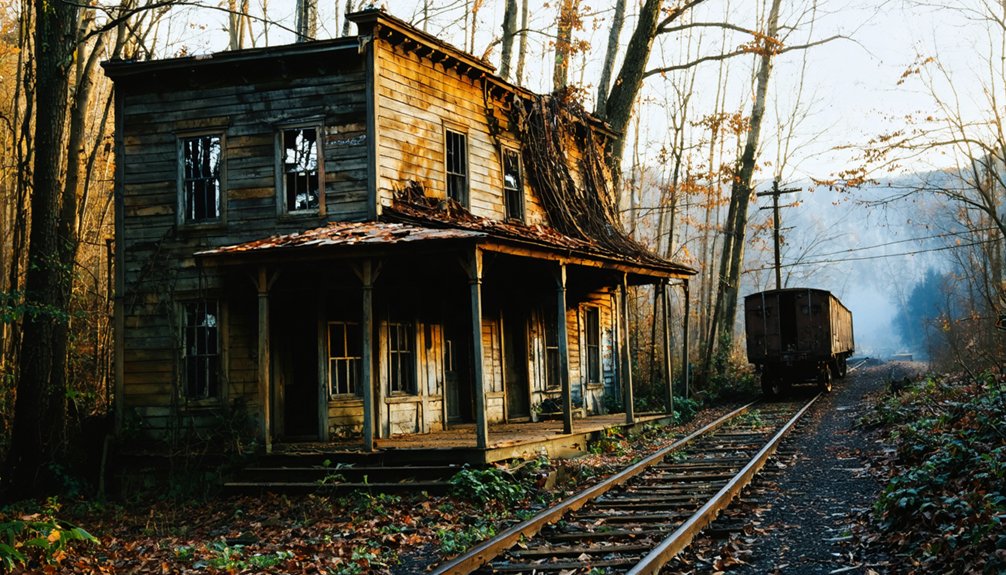
Yale: The Lumber Town That Vanished
Yale’s industrial infrastructure centered on narrow-gauge railroad operations that transported lumber across a 32-mile route. This route connected the Sterling and Yale Lumber Companies to markets via the Licking River and the C&O Railroad at Salt Lick.
Following the Yale Lumber Company’s 1913 sale, workers systematically dismantled company housing and relocated structures to Morgan County lumber camps. This process effectively erased the town’s physical footprint.
The U.S. Army Corps of Engineers submerged the site in the 1970s during Cave Run Lake’s construction. This action permanently entombed the settlement’s remaining archaeological evidence beneath reservoir waters.
Lumber Company Railroad Operations
The Yale Lumber Company’s railroad infrastructure represented a critical engineering achievement that enabled both operational expansion and eventual systematic dismantlement of the entire settlement. This railroad construction transformed timber extraction capabilities while documenting lumber history through its dual-purpose function: resource transportation and community relocation.
The railway system facilitated:
- Equipment transport supporting milling operations in southeastern Bath County
- Lumber shipment to downstream markets beyond traditional river rafting methods
- Complete site evacuation during 1913 sale, including disassembled company houses
You’ll find the railroad’s operational scope extended beyond Yale’s boundaries, ultimately transporting dismantled structures to Morgan County lumber camps. This infrastructure allowed proprietors to liquidate assets efficiently, shipping remaining inventory and reconstructing worker housing at new extraction sites.
The railway exemplified industrial mobility that characterized early twentieth-century resource exploitation.
Relocation and Submersion
Following decades of operational expansion through rail infrastructure, complete industrial abandonment preceded Yale’s eventual inundation by over half a century.
The Yale Lumber Company’s 1913 departure left minimal settlement infrastructure when the U.S. Army Corps of Engineers initiated Cave Run Lake construction in the 1970s. You’ll find authorities systematically acquired properties, forcing residents to relocate from this southeastern Bath County community.
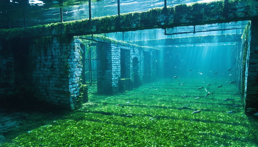
The flooding served flood control objectives, permanently submerging structures along the Licking River corridor. Today’s lake ecology encompasses submerged forests documented through diving exploration, where standing timber remains visible on the lake bottom.
Unlike other relocated communities, no graveyard relocation records exist for Yale. This ghost town represents complete submersion—a settlement erased from Kentucky’s terrestrial landscape, preserved only through photographs and former residents’ accounts.
Cave Run Lake and Its Forgotten Communities
Constructed between 1965 and 1973, Cave Run Lake emerged as the Louisville District Corps of Engineers’ strategic flood control solution for the lower Licking River valley, spanning four counties: Bath, Menifee, Morgan, and Rowan.
The reservoir’s creation displaced established communities like Yale, where families had cultivated fertile floodplain soil enriched by Licking River alluvium deposits for generations. You’ll find beneath the lake’s surface a landscape of submerged infrastructure—remnants of mills, farms, and homesteads that once sustained thriving agricultural operations.
Communities Lost to Cave Run Lake:
- Yale settlement in southeastern Bath County
- Generational farmsteads along the Licking River corridor
- Historic lumber mill sites and company-built residential structures
Today’s recreational waters conceal this displaced heritage, where underwater plant life now colonizes former cornfields and foundations of autonomy-driven communities that vanished under federal acquisition.
Gad, West Virginia: A Cross-Border Displacement Story
While Cave Run Lake represents Kentucky’s displacement narrative, Summersville Lake in Nicholas County, West Virginia illustrates parallel federal land acquisition policies that eradicated established Appalachian settlements.
The U.S. Army Corps of Engineers condemned Gad in the 1960s, forcibly relocating approximately 100 families who’d farmed McKee’s Creek for generations. You’ll find flood mitigation justified this seizure—the dam prevented an estimated $407,400,000 in Kanawha Valley damages.
Construction from 1960-1966 required excavating 2,000 feet to bedrock, submerging the community’s general store, post office, church, and six relocated graveyards.
Today, underwater archaeology reveals stone foundations and roadways when winter drawdowns expose the lakebed. Divers document standing forests and artifacts—children’s marbles embedded in silt—testifying to lives government planners deemed expendable for engineered flood control.
Jocassee Valley’s Haunting Underwater Forests

Beyond Appalachia’s displaced communities, Duke Energy’s 1973 completion of Lake Jocassee demonstrates hydroelectric infrastructure‘s permanent transformation of southeastern ecosystems.
Lake Jocassee stands as testament to modernization’s irreversible reshaping of ancestral valleys into engineered reservoirs.
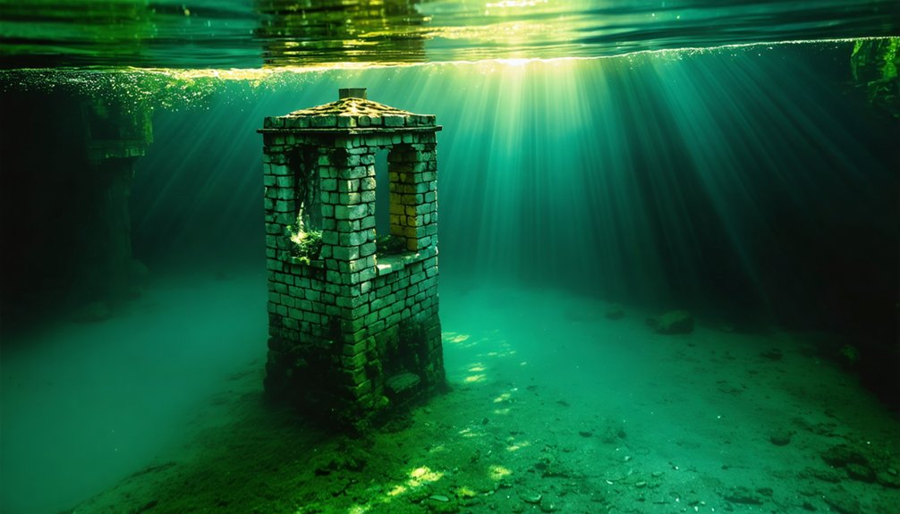
The 365-foot reservoir submerged the entire Jocassee Valley, creating submerged ecosystems where standing forests remain preserved at depth. You’ll find underwater flora creating what divers describe as “moonlit winter woods” beneath 15-50 feet visibility conditions.
Notable Preserved Structures:
- Attakulla Lodge rests intact at 300 feet, basketball court and peeling paint preserved since 1904
- Mt. Carmel Cemetery’s headstones remain readable at 130 feet depth
- Jocassee Camp for Girls stone gateway exceeds 300-foot depth
The Keowee-Toxaway Hydroelectric Project‘s two-year filling process displaced pre-existing communities while creating unique diving conditions.
You’re witnessing engineering’s capacity to permanently alter landscape autonomy—43,000 protected acres surrounding what was once Cherokee territory and family retreats.
Preserving the Memory of Kentucky’s Sunken Towns
Documentation of Kentucky’s submerged communities relies on three primary preservation methodologies: systematically recorded oral testimonies from displaced residents and their descendants, archaeological surveys mapping structural remnants during low-water exposure events, and commemorative installations marking original town boundaries.
You’ll find historians conducting structured interviews to capture firsthand accounts of Birmingham and Burnside before inundation, creating archival records that supplement physical evidence.
These preservation efforts employ GPS coordinates to catalog visible foundations, stone walls, and infrastructure elements, while memorial markers at access points provide contextualized historical narratives for researchers and visitors.
Oral Histories and Testimonies
Through systematic oral history documentation, researchers have recovered critical primary source material regarding Kentucky’s submerged communities that would otherwise remain lost to historical record. Douglas A. Boyd’s methodological approach demonstrates how firsthand testimonies preserve narratives of displacement preceding modern infrastructure development.
You’ll find these accounts document forced relocations, particularly targeting Black populations for their productive alluvial farmland since Reconstruction. The Army Corps’ dam projects created lasting ecological impacts beyond physical submersion.
Key Documentary Evidence:
- Eyewitness accounts detail violent expulsions transforming Birmingham into a sundown town.
- Avocational archaeologists contributed oral data to Hedden Site and Black Branch floodplain records.
- Regional memoirs capture pre-flood community structures now visible only during low water conditions.
These testimonies reveal suppressed histories—townspeople initially withheld traumatic experiences from families, sharing classified information only decades later when physical evidence emerged from receding reservoir waters.
Archaeological Documentation Efforts
While oral testimonies preserve human narratives of displacement, physical evidence beneath Kentucky’s waterways provides tangible archaeological data that corroborates and expands historical records.
Archaeological methodologies employ side-scanning sonar to identify cultural anomalies—wharfs, docks, and mill races—before infrastructure projects commence.
You’ll find targeted dives combine still imagery with visual inspection to distinguish natural bedrock from human-constructed features.
Underwater conservation reveals remarkable survival: Camp Nelson’s waterworks foundation withstood 150 years of currents fifteen feet below surface, while sandstone blocks from mill races remain stacked in muddy conditions.
These surveys document pre-1800 shipbuilding remnants and river pirate hideouts near Cave-in-Rock.
Corn Island’s bedrock, excavated by explosives in the 1860s, exemplifies how systematic documentation recovers Kentucky’s submerged industrial and settlement heritage from deliberate erasure.
Memorial Sites and Markers
Birmingham’s relocated cemetery holds displaced residents at a separate site, while the original townscape functions as underwater art beneath fluctuating depths. You can observe these submerged cemeteries when seasonal drawdowns expose foundations and carved rocks at Birmingham Point.
Physical markers documented at winter pool:
- Whaley’s upright tombstone
- Broken cemetery bases
- Hand-carved memorial rocks
TVA’s 1944 inundation created this cyclical memorial system requiring community participation for continuity.
Frequently Asked Questions
Can Scuba Divers Legally Explore the Submerged Remains of Birmingham?
You can legally dive Birmingham’s submerged remains under TVA regulations requiring standard permits. However, you’re prohibited from disturbing artifacts per underwater archaeology laws. Marine conservation rules don’t restrict exploration, though you’ll need proper scuba certification for autonomous access.
Were Residents Compensated Fairly When TVA Purchased Their Land?
Land acquisition compensation remains disputed. You’ll find TVA’s eminent domain proceedings generated significant grievances, with residents resisting what they perceived as inadequate payment. Evidence suggests compensation disputes reflected power imbalances rather than equitable market-value assessments for displaced property owners.
How Do Fish and Wildlife Interact With Underwater Town Structures?
Submerged structures create artificial reef habitats where aquatic ecosystems flourish. You’ll find marine wildlife colonizing foundations and building materials, as fish populations increase up to 400% around these underwater complexes, establishing diverse biological communities through natural succession processes.
Are There Any Artifacts Recovered From These Underwater Ghost Towns?
You won’t find documented ancient relics or submerged artifacts recovered from Kentucky’s underwater ghost towns. Available evidence shows no systematic recovery efforts, though low water occasionally exposes structural remnants at sites like Birmingham Point.
What Water Level Is Best for Viewing Birmingham’s Visible Foundations?
You’ll observe Birmingham’s foundations best when Kentucky Lake drops to approximately 347 feet or lower—12 feet below summer pool—though this disrupts aquatic ecosystems and challenges historical preservation efforts, requiring TVA’s deliberate drawdown for access.
References
- https://www.onlyinyourstate.com/trip-ideas/kentucky/underwater-ghost-town-ky
- https://www.thewanderingappalachian.com/post/underwater-ghost-towns-of-appalachia
- https://en.wikipedia.org/wiki/Birmingham
- https://www.youtube.com/shorts/U7-djL5yp2c
- https://wbkr.com/underwater-ky-ghost-town/
- https://www.marshallcountydaily.com/2016/08/08/a-walk-through-history-by-justin-lamb-sponsored-by-four-pigs-restaurant-6/
- https://www.fourriversexplorer.com/birmingham-kentucky/
- https://www.fjc.gov/history/cases/cases-that-shaped-the-federal-courts/walker-v-city-birmingham
- https://en.wikipedia.org/wiki/Birmingham_campaign
- https://digitalcommons.library.uab.edu/cgi/viewcontent.cgi?article=1065&context=vulcan