While Mississippi doesn’t have towns literally underwater, you’ll find Rodney—once the state’s busiest port with 4,000 residents—now abandoned after the Mississippi River shifted course two miles west in 1870. The former cotton hub survived an 1843 yellow fever epidemic, Civil War battles, and an 1869 fire, but couldn’t withstand its isolation from the river. Today, structures like the cannonball-scarred First Presbyterian Church (1828-1832) remain threatened by recurring floods, with preservation societies racing against time to document what environmental forces continue eroding.
Key Takeaways
- Rodney, Mississippi became a ghost town after the Mississippi River shifted two miles west in 1870, isolating it from river commerce.
- Multiple floods in 1912, 1927, 1935, 2011, and 2016 progressively submerged Rodney despite the river’s earlier course change.
- The 2011 flood displaced Rodney’s last remaining residents, completing the town’s abandonment after decades of decline.
- Historic structures like First Presbyterian Church and Rodney Baptist Church survived floods but face ongoing threats from water damage.
- Natural river meanderings cause channel shifts every millennium, leaving former riverside settlements stranded and vulnerable to flooding.
The Rise and Fall of Rodney: Mississippi’s Lost River Port
When French settlers established Petit Gulf in 1763 along the Mississippi River’s eastern bank, they couldn’t have anticipated the settlement would evolve into one of the antebellum South‘s most essential commercial hubs before disappearing beneath the waterline.
Renamed Rodney in 1814, you’ll find evidence of its peak prosperity in census records showing 4,000 residents by 1860—surpassing Jackson’s population. The port processed millions of pounds of cotton between New Orleans and St. Louis, establishing it as the region’s busiest shipping point. Dr. Rush Nutt’s development of the “Petit Gulf” cotton strain revolutionized Southern agriculture, as the rot-resistant variety spread across plantations throughout the region.
However, urban decay accelerated after 1869 when fire destroyed critical infrastructure already damaged during Union occupation. Economic decline became irreversible once the Mississippi River changed course, transforming the channel into swampland and severing Rodney’s commercial lifeline permanently. Today, the abandoned town shares its name with various other locations, requiring researchers to specify “Rodney, Mississippi” when documenting this particular ghost settlement.
Natural Disasters That Sealed Rodney’s Fate
Although Rodney survived its 1843 yellow fever epidemic—the settlement’s first documented catastrophe that decimated residents through mosquito-borne transmission—the convergence of subsequent disasters throughout the 1860s proved insurmountable.
Rodney endured disease in 1843, but the relentless cascade of calamities throughout the 1860s ultimately sealed the settlement’s fate.
Union troops plundered homes during September 1864 operations, while Confederate cavalry captured the USS Rattler after its cannonballs struck four residences and embedded in First Presbyterian Church’s facade.
The 1869 fire consumed the village at 2 a.m., witnessed by steamer Richmond officers who documented flames engulfing war-damaged structures.
Catastrophic floods in 1912, 1927, and 1935 continued despite the Mississippi’s 1870 shift two miles westward.
The river’s course change resulted from a sandbar formation that eliminated Rodney’s port access, severing the town’s commercial lifeline.
Urban abandonment accelerated when rain-softened soils undermined brick buildings, and flood recovery became economically unfeasible.
The Jackson and Columbus Railroad bypassed Rodney in favor of Fayette in the early 1880s, further isolating the declining community.
The 2011 inundation ultimately displaced remaining residents, completing Rodney’s transformation into Mississippi’s most documented ghost town.
As the waters rose, similar fates befell other towns across the nation, including the underwater ghost towns in Maryland. These submerged sites offer a haunting glimpse into the past, where the remnants of lost communities still linger beneath the surface. Exploring these areas can evoke a sense of curiosity and nostalgia for a time when these towns thrived above water.
When the Mississippi River Changed Course
The Mississippi River’s restless nature has fundamentally reshaped Rodney’s accessibility throughout recorded history, with the waterway executing its most devastating shift near the settlement in 1870—abandoning its channel and relocating two miles westward. Sediment buildup naturally flattens the river’s gradient over centuries, forcing it to seek steeper paths toward the Gulf.
You’ll find this pattern documented throughout Harold Fisk’s 4,000-year mapping, where the river changed course approximately every millennium. River erosion accelerated Rodney’s isolation as the new channel carved deeper into western terrain, leaving the town stranded without commercial river access. Fisk’s maps employed overlapping color codes to distinguish these temporal layers—green for 1880 courses, salmon-pink for 1820, and light blue for 1765—creating a visual record of the river’s migrations across its meander belt.
Similar avulsions near Reverie, Tennessee in 1876 and Vicksburg that same year demonstrate the river’s systematic abandonment of established channels—transformations that redrew state boundaries and obliterated settlement economies within days. The river’s water flow velocity averages about 1 mph, with retention time of roughly 90 days from Lake Itasca to the Gulf, enabling such gradual but inexorable course changes.
What Remains of Rodney Today
Standing amid encroaching vines and swampy woods where a bustling riverfront once thrived, Rodney’s surviving structures bear witness to 150 years of hydraulic abandonment.
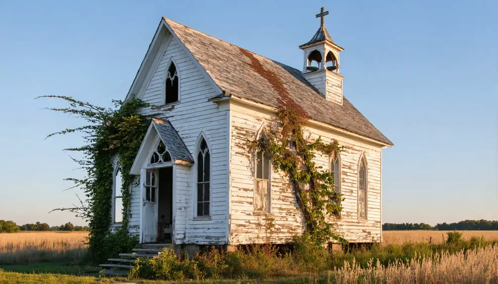
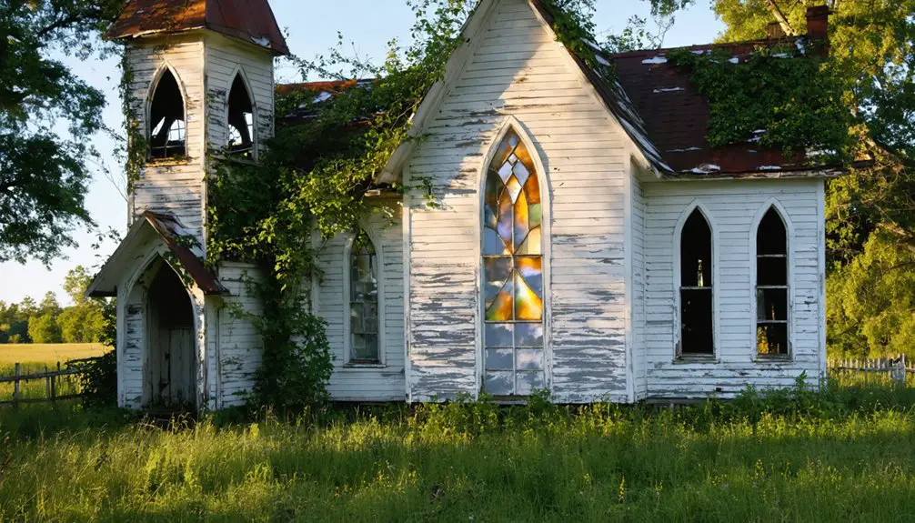
You’ll find two 19th-century churches anchoring this community heritage site: First Presbyterian Church (1828-1832) displays a cannonball replica commemorating 1863’s Union gunboat bombardment, though flood-softened soils collapsed its brick walls.
Rodney Baptist Church’s restored Greek Revival-Gothic architecture survived better, alongside a country store and scattered structures forming the Historic District.
Urban decay progresses relentlessly—the 2011 flood eliminated most remaining residents, while 2016’s muddy waters submerged church foundations.
Four miles separate Commerce Street from today’s Mississippi River channel, marking your physical distance from prosperity.
The Red Brick School from 1846 once served students across two floors as the community’s only public school before abandonment claimed the rest of Rodney’s institutional infrastructure.
At its peak, the town supported 35 stores along with two banks and two newspapers, reflecting the commercial vitality that riverboat traffic and cotton trade generated.
Cemetery hilltops offer winter sightlines to water that once powered 4,000 residents’ fortunes before nature reclaimed this waterlogged monument to impermanence.
Preserving Mississippi’s Submerged History
Despite river relocation eliminating commercial viability, systematic preservation efforts maintain Rodney’s architectural testimony through coordinated restoration initiatives. You’ll find the Rodney History and Preservation Society actively restoring the Presbyterian Church, including its Civil War-damaged façade with replica cannonball.
The Rodney Center Historic District’s National Register status provides critical protection for surviving structures like the 1828-1832 First Presbyterian Church and the restored Mt. Zion Baptist Church. However, you’re witnessing ongoing battles against river ecology impacts—2011 floods devastated remaining buildings, while repeated inundation softens foundations beneath heavy masonry walls.
Floodplain agriculture and natural cycles continue eroding these historical markers. Preservation work acknowledges that protecting Mississippi’s submerged ghost town heritage requires understanding environmental forces while documenting architectural elements before inevitable structural collapse claims remaining testimony.
Frequently Asked Questions
Are There Other Ghost Towns Underwater in Mississippi Besides Rodney?
Time and tide wait for no one. You’ll find submerged settlements like Ben Lomond, New Mexico, Port Anderson, and Prentiss—all abandoned communities claimed by Mississippi River flooding. These documented sites prove Rodney isn’t alone underwater.
Can Visitors Safely Explore Rodney During Flood Season?
You shouldn’t explore Rodney during flood season without serious safety precautions. Waters routinely reach church steps, roads become impassable, and structural instability increases substantially. The remote location offers no emergency services, making independent visits extremely risky during high water.
What Caused the Mississippi River to Shift Its Course in 1870?
Nature’s relentless hand drove the river change through natural avulsion in 1876, not 1870. Sediment buildup and meander dynamics created the flood impact that severed Desoto Peninsula, freeing the Mississippi to chart its own destiny toward the Gulf.
How Do Modern Floods Affect Rodney Compared to Historical Flooding Events?
Modern floods cause more severe structural damage than historical events, with 2011’s waters destroying interiors versus 1927’s elevated-sidewalk survival. You’ll notice climate change impacts worsen frequency, though flood management strategies remain absent in abandoned Rodney.
What Artifacts Have Been Recovered From Flooded Areas of Rodney?
You’ll find Native American artifacts recovered between Rodney’s townsite and Natchez Trace, though underwater archaeology isn’t systematically documented here. Flood recovery efforts focus on preserving existing structures rather than excavating submerged artifacts from repeatedly inundated areas.
References
- https://mississippifolklife.org/articles/haunted-by-a-ghost-town-the-lure-of-rodney-mississippi
- https://theforgottensouth.com/rodney-mississippi-ghost-town-history-tour/
- https://en.wikipedia.org/wiki/Rodney
- https://backroadplanet.com/haunting-rodney-mississippi/
- https://www.susantregoning.com/blog/rodney-ghost-town
- https://www.youtube.com/watch?v=pRwwTB53x-Y
- https://passionsandplaces.com/rodney-mississippi-ghost-town/
- https://www.legendsofamerica.com/ms-rodney/
- https://sethparker.net/rodney-mississippi-the-ghost-town-youve-probably-never-heard-of/
- https://www.youtube.com/watch?v=pvIkHuyxmhw