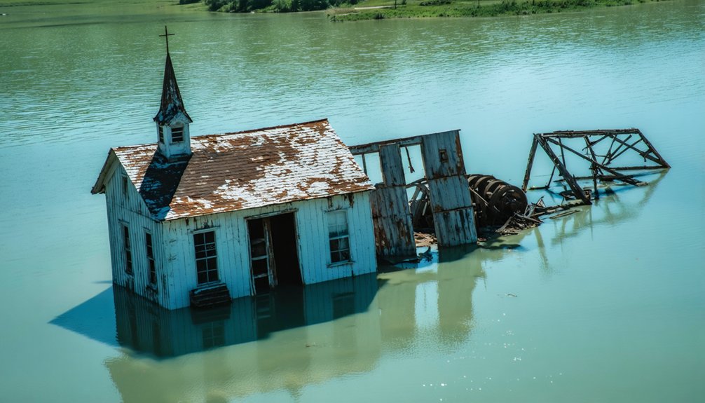
Nebraska’s Lake McConaughy conceals the submerged remnants of Lemoyne, a town systematically displaced through federal eminent domain in 1940 when Kingsley Dam‘s construction began. You’ll find the original settlement—established in the 1880s with 200 residents—now rests under approximately 50 feet of water. During the 2004 drought, water levels dropped to one-fifth capacity, exposing building foundations, the Harris family’s root cellar, pottery fragments, and artifacts from pioneer life. Federal protections prohibit artifact removal, but documented evidence reveals how infrastructure projects transformed Nebraska’s landscape and the archaeological insights these submerged communities provide.
Key Takeaways
- Lemoyne, Nebraska’s most notable underwater ghost town, was submerged in 1941 beneath Lake McConaughy after Kingsley Dam’s construction displaced 110 structures.
- The 1936 dam project used eminent domain to relocate residents, dismantling buildings for “New Lemoyne” while flooding foundations and artifacts under 50 feet.
- Severe droughts in 2004 and 2022 exposed submerged remnants including building foundations, root cellars, pottery fragments, and the 1870 North Alabama steamboat hull.
- Lake McConaughy, Nebraska’s largest lake at 35,700 acres, permanently preserves Lemoyne’s remains and other archaeological sites beneath its waters.
- Federal law prohibits artifact removal or disturbance; exposed remnants are protected under the National Historic Preservation Act for archaeological study only.
The Drowning of Original Lemoyne
When the Union Pacific Railroad extended its branch line through Nebraska’s North Platte Valley in 1909, it set in motion a chain of events that would culminate in an entire town’s submersion beneath Lake McConaughy.
Lemoyne, established in the early 1880s by its namesake Lemoyne Jacobs, grew into a community of 200 residents by the 1920s. However, Kingsley Dam‘s construction beginning in 1936 sealed the town’s fate.
By 1937, you’d have witnessed residents dismantling approximately 110 structures, hauling them north to rebuild as “New Lemoyne.” The original foundations remained submerged under 50 feet of water by 1941.
During a severe drought in 2004, Lake McConaughy’s water levels dropped dramatically, exposing foundations, tree stumps, and pottery fragments from the submerged town.
Historical documentation survives through Cora Baumann’s fifty-year collection and Julius Hoffman’s poem, ensuring cultural preservation despite the town’s physical erasure beneath 30,000 acres of water. The town’s name continues to exist through multiple related locations, though the original settlement lies permanently beneath the reservoir’s waters.
Forced Relocation and Community Upheaval
The federal government exercised eminent domain in 1940 to acquire Lemoyne properties, forcing residents to accept predetermined buyouts regardless of their personal attachments to the community.
You’ll find that residents resisted relocation mandates as long as possible, but ultimately faced compulsory displacement as dam construction progressed through the late 1930s. This systematic dispossession left families unable to recover basements, root cellars, and countless personal belongings—all eventually submerged under approximately 50 feet of water. The shifting river courses that had previously threatened early Missouri River settlements now gave way to engineered flooding that would permanently erase entire communities from the landscape. During severe droughts, the old bank building and other community landmarks become visible again, offering brief glimpses into the submerged town’s former layout.
Eminent Domain and Buyouts
Government authorities exercised eminent domain powers in the late 1930s to acquire properties throughout Lemoyne, initiating a systematic buyout process that would displace the entire community. You’ll find documented cases like Arch and Ivy Harris, forcibly bought out in 1940 and compelled to abandon their root cellar.
Federal authorities prioritized Lake McConaughy’s 30,000-acre reservoir construction over individual property rights, justifying the displacement through public water project mandates. The project was enabled by federal New Deal funding secured through the PWA during the 1930s economic recovery efforts. Despite resident resistance, dam construction proceeded, flooding the original townsite under approximately 50 feet of water.
This governmental flooding authority extended beyond Lemoyne—Crouse faced similar displacement in the late 1960s for Branched Oak Lake’s flood control purposes. These projects, while addressing aquifer contamination concerns and creating wildlife habitat, fundamentally overrode local autonomy and forced wholesale community dispersal.
Emotional Impact on Residents
Forced relocation initiatives consistently triggered profound emotional resistance among Nebraska residents confronting displacement from flood-prone communities.
You’ll find that cultural heritage attachments created substantial barriers, with long-term residents resisting immediate post-flood buyout proposals after maintaining 20-plus year homesteads.
Survey data revealed only 25% of village populations initially supported relocation, demonstrating widespread reluctance to abandon established community bonds.
Historical precedents like Niobrara’s two relocations—costing $40,000 in 1881-82 and $14.5 million in the 1970s—document cumulative psychological tolls from repeated displacement.
Population decline compounded emotional stakes, as residents struggled between preserving village status and confronting engineering realities that levees couldn’t protect against annual flooding threats.
Neighbors arrived skeptical at planning meetings but ultimately confronted impossible choices between safety and community preservation.
The relocation process required substantial personal effort as residents physically jacked up and relocated structures, adding logistical burden to the emotional trauma of leaving ancestral homes.
Post-flood landscapes amplified feelings of abandonment, with quiet streets and absent decorations reflecting the profound loss experienced by remaining residents.
What the Drought Revealed
When Lake McConaughy’s water levels plummeted to one-fifth capacity during the near-record 2004 drought, the original Lemoyne townsite emerged from its submerged state for the first time in decades.
The 2004 drought drained Lake McConaughy to one-fifth capacity, revealing the long-submerged Lemoyne townsite for the first time in decades.
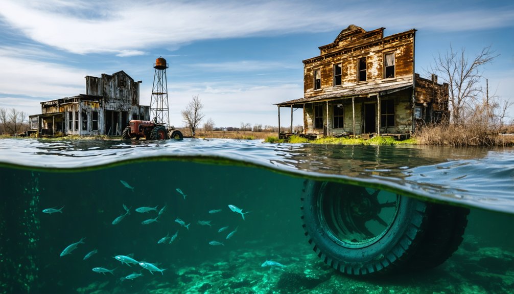
You’ll find building foundations, tree stumps, and pottery fragments marking where structures once stood. Former residents returned to identify their past homes and businesses among the eroded remains.
The environmental impact of decades underwater destroyed intact buildings, leaving only scattered artifacts—glass jars, bottles, and a woman’s shoe sole—at record low water levels.
These remnants document the economic decline that followed forced relocation in the late 1930s when the government created the 30,000-acre reservoir. The exposed townsite offers photography opportunities for those interested in documenting western Nebraska’s submerged history.
The drought exposed what erosion hadn’t claimed, offering tangible evidence of pre-reservoir life before modern conveniences transformed western Nebraska. Abnormally dry conditions have expanded in southeast Wyoming, southern Nebraska, and northeast Kansas, threatening water levels across the region.
Lake McConaughy: Nebraska’s Man-Made Reservoir
The reservoir that drowned Lemoyne spans 35,700 acres at full capacity, making it Nebraska’s largest body of water. You’ll find Lake McConaughy stretching 22 miles long and 4 miles wide, created by Kingsley Dam—one of the world’s largest hydraulic-fill structures at 142 feet deep.
Built between 1936-1941 for $43 million, it serves irrigation and hydroelectric functions through CNPPID operations. The construction provided jobs for over 1,500 workers during the Depression era. The environmental impacts transformed 76-100 miles of shoreline into diverse wildlife habitats supporting record-breaking fish populations, including state-record walleye and striped bass.
You can access public recreation areas while respecting operational boundaries. The 32,500-square-mile drainage from North Platte River maintains this engineered ecosystem, demonstrating how infrastructure reshapes landscapes and creates new ecological niches from submerged settlements.
Artifacts From a Lost Era
When Lake McConaughy’s water levels dropped to historic lows in 2004, you could observe building foundations, root cellars, and household items that had remained submerged since the 1940s.
Archaeologists and historians documented glass jars, pottery fragments, shoe soles, and architectural elements before rising waters again concealed the townsite.
You’re now prohibited from removing artifacts or climbing on exposed structures, as federal and state regulations protect these remnants of Old Lemoyne as an archaeological resource.
Items Found in 2004
As Lake McConaughy’s water levels plummeted to one-fifth capacity in 2004, the original Lemoyne townsite emerged from its decades-long submersion for the first time since the 1930s flooding.
You’ll find historical artifacts that document pioneer existence: a woman’s shoe sole, glass jars, bottles, and pottery fragments scattered across exposed foundations. Local historians cataloged building basements, the Harris family’s root cellar, and weathered tree stumps marking former properties.
Former residents returned to identify home locations, preserving community memories through video documentation before refilling waters concealed the evidence again.
Nearby, the steamboat North Alabama’s hull surfaced simultaneously—a vessel wrecked in 1870 during military supply operations. Erosion had eliminated most above-ground structures, yet these remnants provided quantifiable data about railroad-era settlements and residents’ resistance to forced 1937-1940 relocation.
Preservation and Legal Restrictions
Discovery of these submerged artifacts triggers strict federal protections governing their handling and documentation. The National Historic Preservation Act of 1966 mandates that federal agencies consider impacts on properties eligible for or listed on the National Register of Historic Places.
You’re forbidden from climbing on shipwreck ruins or removing souvenirs from these sites, though photography remains permitted to generate public interest in artifacts preservation. The US Army Corps of Engineers stewards cultural resources on federal lands, implementing historic legislation requirements through partnerships with Nebraska’s State Historic Preservation Office and consulting with the Pawnee Nation.
While you can observe exposed items like shoes, bottles, and Lemoyne’s root cellars during low water periods, physical interaction violates federal law designed to protect these irreplaceable historical resources for future generations.
Nebraska’s Vanishing Towns Phenomenon
Beneath Nebraska’s reservoir waters lie the physical remnants of communities deliberately flooded for water management infrastructure, creating what researchers classify as “sacrificial settlements.” Lemoyne, the most documented case, disappeared under Lake McConaughy’s 30,000 acres when dam waters submerged the original townsite under 50 feet of water following the Tri-County Association’s 1937 relocation plan.
Evidence of forced displacement includes:
- Root cellars and basements abandoned as government eminent domain forced buyouts by 1940
- Foundations and pottery exposed during 2004 drought, drawing former residents to identify their childhood homes
- Shoe soles and glass jars preserved underwater, marking lives interrupted by bureaucratic decree
- Beverly Harris’ grandparents’ root cellar resurfacing decades later, contradicting interesting folklore and local legends about complete erasure
Documentation through historic maps and oral histories enables you to verify these systematically erased communities.
The North Alabama Steamboat Discovery
While deliberate flooding created Nebraska’s underwater ghost towns, natural river dynamics periodically reveal older casualties of westward expansion.
The history of Beaver, Minnesota ghost town offers another glimpse into the past, showcasing how community lifelines were severed by changing economic fortunes. As with many ghost towns in America, remnants of structures and stories of former inhabitants invite exploration and reflection on the transient nature of settlement. Each deserted street and crumbling facade tells a tale of ambition, struggle, and eventual abandonment.
Deliberate flooding submerged Nebraska settlements, while shifting rivers expose forgotten wrecks from America’s westward migration era.
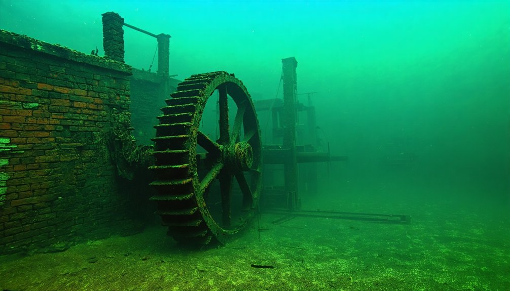
You’ll find the North Alabama steamboat’s 170-foot hull emerging during droughts, first in 1904, then 1906, the 1930s, 2004, and most recently in 2022. This 220-ton packet sank October 27, 1870, after hitting a snag near Goat Island, losing $12,000 in flour and whiskey cargo destined for Montana.
Marine archaeology benefits from these periodic exposures—bleached timbers showcase 19th-century shallow-draft design without invasive excavation.
River conservation principles guide current management: authorities won’t disturb the wreck within Missouri National Recreational River boundaries.
The vessel transported homesteader supplies westward and precious metals eastward, serving Yankton’s steamboat port during peak traffic years.
Exploring Submerged History Responsibly
When drought conditions dropped Lake McConaughy’s water levels in 2004 and again in 2022, former residents returned to identify foundations where their homes and businesses once stood. These exposed remnants—tree stumps, broken pottery, root cellars—reveal how weathering processes have eroded original structures submerged under approximately 50 feet of water since 1941.
Water erosion has transformed these sites into underwater ecosystems, leaving minimal visible evidence above the waterline.
You can explore this history without disturbing submerged sites:
- Access Cora Baumann’s 50-year collection at NSHS Archives documenting displaced families
- View exposed foundations during drought periods when water naturally recedes
- Watch documentation like DK5203Z’s YouTube video capturing visible remnants
- Research family connections through historical records rather than physical site disturbance
These methods preserve both ecological integrity and historical memory.
Frequently Asked Questions
How Deep Is Lake Mcconaughy at Its Deepest Point?
You’ll find Lake McConaughy’s maximum depth reaches 142 feet near Kingsley Dam. This precise lake depth measurement, taken at full capacity, potentially conceals submerged structures from Nebraska’s past, offering you unrestricted exploration opportunities in the state’s deepest reservoir.
Can You Scuba Dive to See the Submerged Town Foundations?
No specific scuba diving permissions exist for underwater exploration of submerged Nebraska town foundations. You’re prohibited from disturbing these historical sites, though scuba diving safety regulations don’t explicitly address accessing them when water levels permit visibility.
What Compensation Did Lemoyne Residents Receive for Their Properties?
Lost to time’s fog, property compensation details for Lemoyne residents remain undocumented. You’ll find historical preservation records confirm government eminent domain buyouts occurred in 1940, but specific monetary amounts weren’t recorded in available archives.
Are There Other Submerged Towns in Nebraska Besides Lemoyne?
Yes, you’ll find Crouse submerged beneath Branched Oak Lake since the late 1960s. Its remnants emerge during low water levels, offering tourist exploration opportunities and historical preservation challenges that document Nebraska’s flood control legacy and lost communities.
How Often Does Drought Lower the Lake Enough to Reveal Artifacts?
Drought impact on artifact visibility occurs sporadically without fixed intervals—you’ll see Lemoyne’s remnants only during severe droughts like 2004’s near-record event, when water levels drop to one-fifth capacity or lower, exposing foundations beneath normally fifty-foot depths.
References
- https://www.onlyinyourstate.com/experiences/nebraska/underwater-ghost-town-ne
- https://history.nebraska.gov/finding-nebraskas-ghost-towns/
- https://nebraskapublicmedia.org/news/news-articles/drought-has-dried-up-rivers-and-lakes-revealing-abandoned-towns-and-shipwrecks/
- https://negenweb.us/knox/stories/ghosttowns.htm
- https://ruralresurrection.com/ghost-towns-lemoyne-nebraska/
- https://en.wikipedia.org/wiki/List_of_flooded_towns_in_the_United_States
- https://en.wikipedia.org/wiki/Lemoyne
- https://history.nebraska.gov/flashback-friday-encore-town-of-lemoyne-sacrificed-for-lake-mcconaughy-1941/
- https://visitkeithcounty.com/explore/surrounding-area/lemoyne/
- https://nebraska.tv/archive/what-ever-happened-to-old-lemoyne


