
Lake Mead’s receding water levels have exposed St. Thomas and at least eight other Nevada settlements submerged since Hoover Dam’s 1938 completion. You’ll find archaeological remnants at coordinates 36.46583°N 114.37028°W, where foundations of schools, stores, and homes reveal a Mormon colony established in 1865 and abandoned in 1871 due to territorial tax disputes. The reservoir’s formation flooded communities including Fort Callville, Junction City, Kaolin, and Rioville—sites now protected under archaeological preservation laws and documented through drone imaging and 3-D spatial mapping technologies that capture structural details before environmental degradation erases them.
Key Takeaways
- Lake Mead’s formation in 1938 submerged multiple Nevada settlements including St. Thomas, Rioville, Fort Callville, Junction City, and Kaolin.
- St. Thomas, founded in 1865 by Mormon settlers, was abandoned in 1871 due to tax disputes before eventual submersion.
- Hoover Dam construction from 1931-1936 created Lake Mead, permanently flooding historic towns and altering the Colorado River ecosystem.
- Receding Lake Mead water levels since the early 2000s have exposed ruins of submerged towns, revealing foundations and structures.
- Advanced technologies like drones and 3-D imaging now document re-emerged archaeological sites before further environmental degradation occurs.
The Rise and Fall of St. Thomas: A Mormon Settlement Lost to Progress
When Brigham Young ordered the colonization of Nevada’s Muddy River Valley in 1865, Mormon settlers under Thomas Smith’s leadership established St. Thomas near the Virgin and Muddy Rivers confluence.
St. Thomas arose at the rivers’ meeting point under Thomas Smith’s direction, fulfilling Brigham Young’s 1865 colonization mandate for Nevada’s Muddy Valley.
The settlement’s historical architecture emerged rapidly—forty-five families constructed dwellings and cultivated 600 acres by 1866. Population peaked at 500 residents.
An 1870 boundary survey altered territorial jurisdiction, repositioning Nevada’s border eastward. Nevada authorities demanded five years’ back taxes in gold.
Following Young’s counsel, LDS members voted to abandon rather than comply with taxation mandates.
February 1871 witnessed systematic destruction—settler narratives document burning homes and crops before migration to Utah’s Long Valley. Daniel Bonelli remained as a notable exception, maintaining the post office and lodging for travelers during the abandonment period.
You’ll find the ultimate abandonment came decades later: Lake Mead’s formation forced final evacuation in 1938, submerging ruins that periodically resurface during drought conditions. The town’s name honored Thomas Smith, whose leadership proved instrumental in the initial settlement establishment.
How Hoover Dam’s Construction Changed the Landscape Forever
The same federal imperatives that doomed St. Thomas drove Hoover Dam‘s unprecedented transformation of the Colorado River ecosystem. You’re witnessing how damming impact fundamentally altered 1,450 miles of watershed between 1931-1936.
Engineers excavated to bedrock, poured 3.25 million cubic yards of concrete, and created a 221-meter gravity-arch structure that halted natural river flows entirely. This river transformation eliminated seasonal flooding patterns that sustained native species for millennia, devastating four fish populations and converting the delta into a hypersaline inverse estuary.
Lake Mead’s filling prevented water from reaching the delta for six consecutive years. While 1.3 million homes gained electricity and 1.5 million acres received irrigation, the infrastructure irrevocably modified sediment transport, water chemistry, and floodplain dynamics—demonstrating how centralized resource management prioritizes human consumption over ecological preservation. The dam’s design featured a thick bottom foundation that tapered toward its crest, with a convex face and curving arch transmitting immense water pressure into Black Canyon’s walls. The project’s 17 generators continue converting the Colorado River’s energy into electricity that powers millions across the southwestern United States.
Life in St. Thomas Before the Flood: Peak Years and Daily Existence
How did a remote desert settlement sustain 500 residents without electricity or indoor plumbing? St. Thomas thrived through systematic resource utilization and self-sufficient infrastructure.
As Pah-Ute County’s seat, you’d find established farming techniques exploiting the Muddy River valley’s alluvial deposits. The settlement functioned as a critical waypoint on the Arrowhead Trail, connecting Los Angeles and Salt Lake City.
Essential infrastructure supported autonomous living:
- School and post office maintained educational and communication networks
- Grocery stores, hotel, and multiple garages served residents and travelers
- Church and soda fountain facilitated community traditions and social cohesion
- Bonelli’s Ferry enabled Colorado River crossings for commerce
Water storage proved equally critical, with multiple cisterns distributed throughout town holding several months’ supply filtered through charcoal and sand. Mormon settlers revived this frontier economy in the 1880s, establishing farms and businesses that demonstrated successful desert colonization without modern utilities—proving human adaptation trumps technological dependence. The town’s location at the confluence of the Muddy and Virgin Rivers provided essential water resources for agricultural development.
The Great Abandonment: Why Residents Left Their Desert Home
The abandonment of St. Thomas resulted from compounding governmental pressures beyond the federally mandated dam construction.
A 1930s border survey revealed the town’s actual Nevada location, triggering a retroactive five-year tax demand from state authorities that financially devastated residents already facing relocation.
As Lake Mead’s waters approached in 1938, departing residents including final holdout Hugh Lord systematically burned their structures rather than surrender them to submersion, eliminating any salvageable equity from properties the federal government had promised to reimburse.
The town had thrived at its peak with 500 residents and amenities including a post office and an ice cream parlor before the dam’s construction forced its evacuation.
Originally established by Mormon pioneers in 1865, the settlement was first abandoned in 1871 due to high taxes, only to be resettled by miners and ranchers who built a prosperous community that lasted until the flood.
Border Survey Tax Shock
Before federal acquisition and Hoover Dam construction drove St. Thomas underwater, a devastating border dispute nearly destroyed the settlement decades earlier. You’d discover that an 1870 survey relocated the Nevada-Arizona boundary, unexpectedly placing St. Thomas within Nevada’s jurisdiction. This geographic reclassification triggered immediate tax controversy when Nevada demanded back taxes from residents who believed they’d been paying Arizona authorities.
The financial impact proved catastrophic:
- Residents faced retroactive taxation spanning multiple years
- Mormon pioneers, already struggling with desert agriculture, couldn’t afford dual tax burdens
- Property values collapsed as families abandoned their homesteads
- Population declined from 500 to minimal occupancy within months
This tax shock represented governmental overreach that forced self-reliant pioneers from land they’d cultivated. The settlement never recovered its economic essential, making subsequent federal acquisition merely the final blow to an already compromised community. St. Thomas had originally been founded in 1865 by members of the LDS Church who established the agricultural community in what they believed was Arizona territory. The town briefly served as Nevada’s county seat despite its remote desert location and small population.
Nevada’s Five-Year Demand
Nevada authorities compounded the border survey catastrophe by imposing a five-year retroactive tax assessment on St. Thomas residents in 1865. You’ll find this fiscal mandate triggered immediate economic decline across the settlement.
The retroactive burden demanded payment for years residents believed they’d lived under Utah jurisdiction, creating an untenable financial situation for homesteaders already operating on marginal profit margins.
This administrative action catalyzed mass population migration as families calculated their economic viability. The compounding effect of jurisdictional uncertainty and unexpected tax liability eliminated any rational incentive to remain.
Within months, you’d observe systematic abandonment as residents relocated to territories offering fiscal stability. The demographic exodus demonstrated how bureaucratic miscalculation transforms viable communities into abandoned settlements.
This process preceded St. Thomas’s eventual submersion beneath Lake Mead’s waters by decades.
Burning Homes Before Departure
When federal authorities finalized property acquisition protocols in 1932, St. Thomas residents confronted displacement from their ancestral lands. You’ll discover that Hugh Lord’s deliberate arson wasn’t isolated defiance—systematic property destruction preceded evacuation across the settlement. This autonomous resistance reflected settlers’ rejection of governmental overreach into their established lives.
The burning strategy served multiple purposes:
- Preventing federal appropriation of personal property improvements
- Denying bureaucratic control over family homesteads
- Asserting individual agency against compulsory relocation mandates
- Eliminating structures that would become flood effects hazards in rising waters
Beneath the Surface: What Remains of the Submerged Town
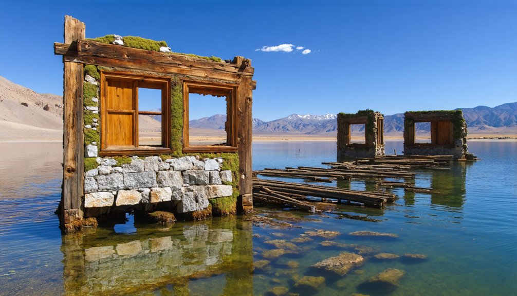
Since Lake Mead’s water levels began receding in the early 2000s, the structural remains of St. Thomas reveal significant archaeological data about submerged architecture. You’ll find foundations from the school, ice cream parlor, and post office exposed at coordinates 36.46583°N 114.37028°W.
These underwater artifacts spent decades at 60-70 feet depth before complete exposure by 2002. The prolonged submersion caused substantial erosion to the original structures, yet identifiable bases and remnants persist.
You can access the site independently via a short dirt trail from the parking area, 60 miles northeast of Hoover Dam.
National Park Service staff archaeologists conduct ongoing research at the St. Thomas Interpretive Center in Overton, documenting this Muddy River settlement‘s history without requiring permits or restrictions.
Pueblo Grande De Nevada: the Ancient Lost City Older Than St. Thomas
Long before St. Thomas emerged, you’ll find Pueblo Grande de Nevada‘s archaeological record stretching to 8000 BC. The Basketmaker people established permanent settlements around 300 AD, engineering sophisticated pit-house structures along the Virgin-Muddy River confluence.
Ancient Puebloans expanded this desert ecozone hub until 1150 AD, creating pueblos exceeding 100 rooms.
Archaeological evidence reveals advanced civilization markers:
- Agricultural innovation: Irrigated cultivation of corn, beans, and squash supported 50-100 residents
- Trade networks: Salt and turquoise mining facilitated coastal exchanges for seashells
- Nutritional diversity: Wild foraging and hunting supplemented cultivated crops with natural ancient probiotics
- Craft specialization: Fine cotton weaving and decorated pottery production
Mark Harrington’s 1924 excavations documented 45 homesteads across multiple occupation periods.
Climate-induced drought forced abandonment around 1250 CE, preserving this pre-Columbian settlement’s archaeological integrity.
When Drought Reveals History: St. Thomas Emerges From Lake Mead
As Lake Mead’s water levels dropped during persistent drought conditions in the early 2000s, St. Thomas resurfaced after 64 years of submersion. You’ll find the town first emerged in 2002, revealing adobe walls, foundations, and cisterns preserved beneath silt.
Water level measurements show continuous exposure since 2003, with the site remaining mainly above water since 2004.
Historical artifacts scattered throughout the ruins provide tangible evidence of the community’s forced abandonment in 1938.
The National Park Service now protects this ghost town, allowing you unrestricted access via dirt road near Overton Arm.
The ice cream parlor’s chimney—once the town’s highest structure—stands exposed again, marking where waters previously submerged it under 60 feet of Lake Mead.
Exploring the Ruins: A Visitor’s Guide to the Exposed Ghost Town
You’ll find St. Thomas ruins approximately 60 miles northeast of Las Vegas via the North Shore Road entrance to Lake Mead National Recreation Area.
The exposed foundations include remains of the ice cream parlor, post office, and schoolhouse, with concrete structures remaining in documented condition for archaeological study.
National Park Service regulations prohibit removing artifacts and require visitors to maintain marked pathways to prevent structural degradation of the 1865-1938 settlement.
Accessing the Historic Site
Located 60 miles northeast of Hoover Dam within Lake Mead National Recreation Area, the St. Thomas site requires strategic planning for independent exploration.
You’ll navigate Interstate 15 to Valley of Fire Highway, then proceed past Northshore Road’s mile marker 46 onto the 3.5-mile Old St. Thomas access road. A 4×4 vehicle guarantees ideal traversal of unpaved terrain.
Access Requirements:
- Lake Mead National Recreation Area entrance fee or valid park pass
- Self-sufficient water supply (no on-site sources available)
- GPS verification (mapping apps frequently misdirect to cemetery)
- High-clearance vehicle for road conditions
The 2.5-mile trail descends 85 feet through sedimentary deposits where water recycling patterns shaped the lake bed.
Interpretive plaques document the settlement’s cultural significance, from 1865 Mormon establishment through 1938 relocation, preserving autonomy in historical exploration without guided restrictions.
Notable Structures and Foundations
Water infrastructure dominates the archaeological record. Concrete-lined cisterns mark every residential foundation, reflecting desert survival requirements.
You’ll observe canal systems extending from the Muddy River, constructed in 1869 to support agricultural production. These engineered water distribution networks enabled cotton, grain, and fruit cultivation in this arid environment, demonstrating the settlement’s technological adaptation.
Safety and Preservation Guidelines
Visiting St. Thomas requires adherence to strict protocols balancing tourist safety with environmental conservation. You’ll navigate desert terrain demanding extensive preparation while respecting preservation mandates under the National Historic Preservation Act and Nevada statutes.
Essential compliance measures include:
- Artifact prohibition: You can’t remove materials; state law reserves title to archaeological resources with penalties reaching $2,000 fines and six months incarceration.
- Non-contact policy: Don’t touch or disturb structural foundations to prevent degradation.
- Permit requirements: Field investigations necessitate authorization on federal and state lands.
- Resource reporting: You must report discoveries while maintaining site confidentiality.
Prepare for rattlesnakes, extreme heat, and flash flood potential near the fluctuating lakebed. The National Park Service maintains focused preservation efforts, unlike typical Nevada ghost towns, enabling your autonomous exploration within established parameters.
as you experience ocala’s ghost town history, you’ll discover the unique stories that shaped this once-thriving community. Each weathered building and abandoned street holds whispers of the past, inviting visitors to unlock the secrets of days gone by. Don’t forget to bring your camera; the hauntingly beautiful scenery is a perfect backdrop for capturing memories.
Modern Archaeological Discoveries Using Cutting-Edge Technology
As Lake Mead’s water levels have receded to historic lows, researchers have deployed advanced drone and 3-D imaging systems to document the re-exposed Pueblo Grande de Nevada site with unprecedented precision. This technological innovation enables exhaustive spatial mapping of the 100-room complex and surrounding agricultural areas before further erosion occurs.
Digital scanning captures deteriorating structures that submersion damaged, creating permanent records of architectural configurations. You’ll find these methods revolutionize archaeological preservation by eliminating constant physical presence requirements while maximizing data collection efficiency.
Recovered artifacts—including tools, weapons, and skeletal remains—reveal maize and bean cultivation patterns spanning over a millennium.
The National Park Service coordinates interdisciplinary teams integrating traditional excavation techniques with cutting-edge documentation systems, ensuring critical cultural heritage survives despite ongoing environmental degradation from drought-induced exposure.
Other Forgotten Settlements Sleeping Under Lake Mead’s Waters
Beyond St. Thomas, Lake Mead’s reservoir submerged multiple documented settlements during the 1930s formation period.
Fort Callville, established as a Colorado River port in 1864, now rests beneath the lake’s western basin alongside the industrial communities of Kaolin and Junction City.
The reservoir’s expansion permanently inundated Rioville, the original county seat, erasing critical administrative infrastructure from Nevada’s territorial development era.
Fort Callville’s Submerged History
When Hoover Dam’s concrete structure reached completion in 1935, the impounded Colorado River began inundating a network of settlements that had anchored southeastern Nevada’s economy for seven decades. Fort Callville represents one such submerged archaeological site, where ancient artifacts and river legends converge beneath Lake Mead’s fluctuating waters.
The reservoir’s expansion erased multiple Mormon settlements established between 1865-1880:
- St. Thomas: Commerce hub with agricultural infrastructure at Muddy-Virgin confluence
- Junction City: Ferry operations and mining center under Bonelli family management
- Kaolin: Clay mining settlement supporting regional industrial development
- Rioville: Agricultural community cultivating orchards along riparian corridors
You’ll find these sites protected under the National Archaeological Protection Act of 1979, though drought-induced water level recession periodically exposes structural remnants, enabling scientific documentation of pre-reservoir settlement patterns.
Kaolin and Junction City
While St. Thomas garners attention, you’ll find Kaolin and Junction City equally significant in Lake Mead’s submerged archaeological record. Kaolin’s 1908 survey established infrastructure supporting 100 residents by 1930. They utilized underground artesian wells for agricultural operations before its 1941 submersion.
The Nevada Land & Livestock Company’s initial development preceded the LDS church’s 1910 Armenian settlement attempt. This attempt failed due to environmental constraints.
Junction City, founded in 1869 at the Colorado-Virgin confluence, functioned as the uppermost navigable steamboat terminus from 1879-1887. Captain Jack Mellon’s Gila operations and Bonelli’s Ferry established critical transportation networks near ancient petroglyphs, marking indigenous presence.
Both settlements’ abandonment in the 1930s preceded federal reservoir filling. Their cemetery relocations in 1935 demonstrated systematic documentation protocols.
Water recession now exposes structural remnants. This provides archaeological access to Nevada’s frontier settlement patterns.
Lost County Seat Remains
The town’s infrastructure included:
- Post office, general store, and ice cream parlor serving 500 residents by 1930.
- Cemetery relocated to Overton before 1938 inundation.
- Agricultural trade networks supporting regional commerce.
- Administrative functions as territorial settlement hub.
Federal acquisition preceded Hoover Dam’s 1935 dedication. Hugh Lord, the final resident, departed June 11, 1938, after steering from his doorstep.
The site remained submerged at 60-foot depths until 2003, when persistent drought conditions exposed foundations.
You can now access these ruins through Lake Mead National Recreation Area‘s protected archaeological zones.
Frequently Asked Questions
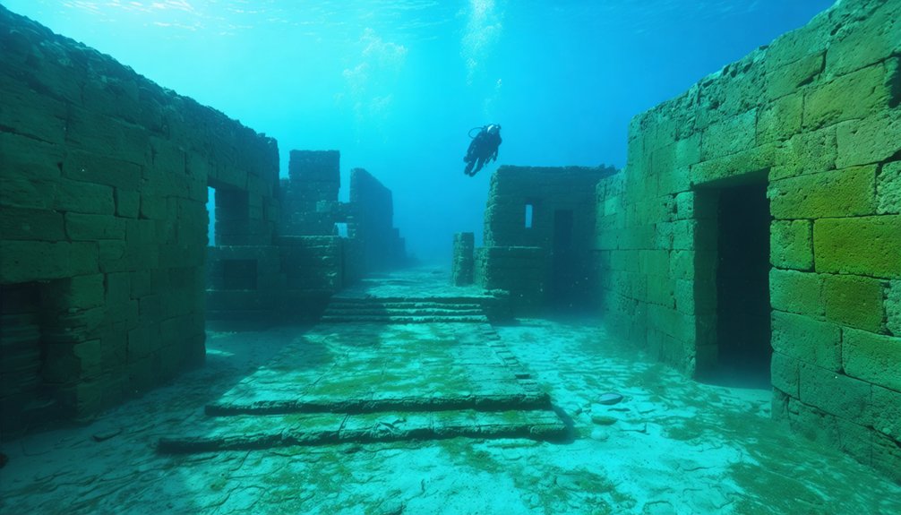
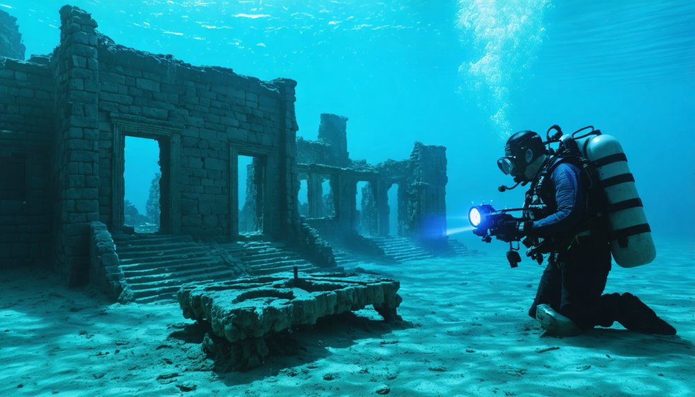
Can You Scuba Dive to See the Ruins When Underwater?
You can’t scuba dive St. Thomas since 2002—water levels dropped 50+ feet, exposing ruins. Underwater exploration isn’t necessary now. When submerged, diving safety protocols and National Park Service restrictions prevented unauthorized access to these protected archaeological sites anyway.
What Happened to Personal Belongings Left Behind by Residents?
Personal belongings left behind became submerged artifacts. You’ll find that lake submersion preserved items for decades until droughts enabled artifacts retrieval. Researchers now document exposed personal belongings using scientific methods, though erosion threatens their preservation.
Are There Any Photos of St. Thomas Before It Flooded?
Yes, you’ll find pre-flood photographs in UNLV Libraries’ archives, documenting St. Thomas’s haunted history through images of abandoned structures including the Gentry Hotel, ice cream parlor, stores, and cottonwood-marked townsite before 1938’s inundation.
How Deep Is Lake Mead at Its Deepest Point?
Lake Mead’s desert reservoir plunges to 590 feet (180 meters) at maximum capacity, though you’ll find it around 400 feet deep today—still sufficient to cloak submerged history beneath fluctuating waters governed by precipitation and allocation policies.
What Causes Lake Mead’s Water Levels to Fluctuate so Dramatically?
You’re witnessing dramatic fluctuations from a 20-year drought, overallocated 1922 Colorado River Compact, 800,000 acre-feet annual evaporation, and increased demand. Poor water management creates ecological impacts, threatening your access to resources as levels approach critical thresholds.
References
- https://www.ldsliving.com/3-underwater-mormon-ghost-towns-you-can-see-today/s/82896
- https://www.reviewjournal.com/local/local-nevada/abandoned-but-not-forgotten-5-ghost-towns-in-southern-nevada-3351038/
- https://travelnevada.com/ghost-town/ghost-towns-near-las-vegas/
- https://lasvegas.citycast.fm/history-archive/creation-of-underwater-ghost-town
- https://en.wikipedia.org/wiki/St._Thomas
- https://www.youtube.com/watch?v=JnIIQymTY3w
- https://www.wef.org/publications/news/wef-news/ghost-town-emerges-from-the-depths-of-lake-mead/
- https://www.nvexpeditions.com/clark/stthomas.php
- https://www.nps.gov/lake/learn/nature/st-thomas-nevada.htm
- https://orc.library.atu.edu/atu_faculty_books/63/


