
You’ll find the remains of at least eighteen complete New England communities submerged beneath major reservoirs, deliberately flooded between 1915 and 1950. Quabbin Reservoir alone drowned four Massachusetts towns—Dana, Enfield, Greenwich, and Prescott—displacing 2,500 residents. Maine’s Flagstaff Lake covers settlements from the 1800s, while Rhode Island’s Scituate Reservoir submerged nine villages. During droughts, foundation walls, street grids, and infrastructure emerge at depths around 80 feet. The systematic documentation reveals how eminent domain erased these townships to supply water and power to Boston, Providence, and Hartford.
Key Takeaways
- New England reservoirs like Quabbin, Flagstaff Lake, and Scituate submerged entire towns through dam construction between 1915-1950.
- Over 2,500 residents were displaced from communities including Dana, Prescott, Greenwich, and Enfield through eminent domain and forced relocation.
- Droughts expose submerged ruins including building foundations, stone walls, bridges, and street grids at depths around 80 feet.
- Thousands of graves were relocated before flooding, though some remain underwater along with demolished buildings and infrastructure.
- Underwater archaeology, LiDAR scanning, and shoreline surveys document these lost communities and preserve their historical memory.
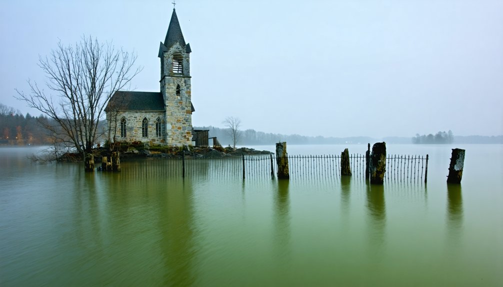
The Drowned Townships of Flagstaff Lake, Maine
When Central Maine Power shuttered the gates of Long Falls Dam in 1950, it erased two centuries of settlement from the map.
The dam’s closure drowned generations of history, submerging entire communities beneath what would become Flagstaff Lake’s sprawling waters.
You’ll find Flagstaff Lake covering 20,300 acres where thriving townships once stood.
The flooding destroyed historic architecture dating to the 1800s—Myles Standish’s gristmill, sawmill, and homes built by settlers drawn to Dead River’s rich soil.
CMP began land acquisition in 1930, clearing the flowage area by 1948.
Community memories vanished as crews razed buildings and exhumed cemeteries for reburial elsewhere.
By summer 1949, smoke from burning brush engulfed Flagstaff during its final Old Home Days celebration.
Some residents refused compensation, leaving their houses standing as waters rose.
Today, foundations emerge on clearest days—physical evidence of townships seized through eminent domain despite fierce resistance.
The submerged remains now attract visitors for summer recreation and snowmobiling, most unaware of the ghost town concealed beneath the water’s surface.
Flagstaff Memorial Chapel stands as a tribute to those who built the community before the flood.
Quabbin Reservoir: Four Massachusetts Towns Lost to Boston’s Water Supply
As Boston’s population surged following the 1905 completion of Wachusett Reservoir, the city’s existing water infrastructure—already strained by widespread adoption of indoor plumbing—proved insufficient for metropolitan demands.
You’ll find that the 1927 Swift River Act authorized condemning Dana, Enfield, Greenwich, and Prescott—disincorporated simultaneously on April 28, 1938. Engineering challenges required constructing Goodnough Dike and Winsor Dam between 1930-1935, while the Quabbin Aqueduct tunnel extended infrastructure to the Swift River Valley.
The environmental impact proved devastating: 2,500 residents displaced, 7,500 bodies exhumed, and 14 mills demolished. Authorities systematically removed vegetation before burning the valley for months. The reservoir spans 39 square miles, submerging everything except 60 hilltops. Construction spanned seven years to fill the basin completely, from 1939 to 1946. Workers earned 62.5 cents per hour during the Depression, with the project providing thousands of jobs.
Today, Dana Common’s cellar holes remain visible above the waterline—silent testimony to state power overriding local sovereignty.
Valley Forge Beneath Saugatuck Reservoir, Connecticut
While Boston’s Quabbin project displaced four towns, Connecticut’s Saugatuck Reservoir erased the 18th-century manufacturing settlement of Valley Forge through a parallel exercise of state-sanctioned condemnation.
Connecticut’s exercise of eminent domain drowned Valley Forge’s industrial legacy beneath the Saugatuck Reservoir, mirroring Massachusetts’ displacement of entire communities for water infrastructure.
You’ll find this iron and steel hub—which supplied tools for the War of 1812 and Civil War—submerged 100 feet beneath 12 billion gallons since 1942.
The Bridgeport Hydraulic Company acquired 4,500 acres between 1920-1936, seizing remaining parcels via eminent domain after courts crushed resident opposition.
Charles H.D. Adelbert Whitlock’s glass plate negatives, discovered in 1969, preserve critical cultural artifacts documenting the settlement’s industrial infrastructure.
James Lomuscio’s 2005 University of New England Press study reconstructs the town’s trajectory through historic photographs and resident testimonies.
The reservoir was created to supply water to Fairfield County’s industrial needs, supporting manufacturing growth throughout the region.
Today’s 827-acre reservoir exhibits minimal environmental impacts—stone walls emerge during drawdowns, revealing the forcible transformation of productive communities into municipal water supplies serving Norwalk and Bridgeport.
Scituate Reservoir’s Nine Vanished Villages in Rhode Island
Rhode Island’s Scituate Reservoir displaced nine villages between 1915 and 1925, submerging 1,195 buildings to create the state’s primary water supply for Providence.
Authorities relocated 5,000 graves from family cemeteries to New Rockland Cemetery before flooding commenced, marking one of the largest cemetery relocations in New England history.
During severe droughts, stone foundations, mill remnants, and roadbeds emerge from the receding waterline, revealing the infrastructure of communities that served 3,000 displaced residents.
Villages Lost to Flooding
On April 9, 1915, the Rhode Island General Assembly authorized the seizure of 14,800 acres in Scituate, initiating a decade-long project that would erase nine villages from the map.
You’ll find that Ashland, Kent, Ponaganset, Richmond, and Rockland villages disappeared entirely, along with Wilbur Hollow, Saundersville, South Scituate, and Elmdale.
The Providence Water Supply Board’s condemnation proceedings destroyed 1,195 structures—375 homes, 233 barns, 30 dairy farms, 7 schools, and 6 churches.
Approximately 1,600 residents were displaced from their homes, with lawsuits challenging the forced relocations ultimately dismissed by the courts.
Preservation challenges intensified as archaeological controversies emerged over lost Native American sites, including Council Throne and Indian Rock.
The Y-shaped reservoir now spans 5.3 square miles, submerging 36 miles of roads and the Providence and Danielson Electric Railway beneath 60 feet of water, eliminating irreplaceable cultural heritage.
The dam’s completion on November 10, 1925 allowed the reservoir to begin filling, ultimately holding 39 billion gallons of water by September 1926.
Relocated Graves and Headstones
Among the most profound disruptions caused by the Scituate Reservoir project, the displacement of the dead required systematic excavation and reinterment of hundreds of graves from family cemeteries scattered throughout the condemned valley.
Relocated graves from Ashland, Kent, Ponaganset, Richmond, Rockland, Saundersville, South Scituate, Elmdale, and Fiskeville converged at New Rockland Cemetery—a centralized repository designed to replicate the original burial grounds’ appearance.
Headstone preservation remained paramount throughout the forced removal process, with markers carefully repositioned to maintain family plot configurations.
Providence’s eminent domain authority compelled this decade-long operation, preventing 375 families’ ancestral remains from submersion beneath 80 feet of water. Over 1,500 graves were exhumed and reburied, though many potentially remain beneath the water.
Raymond A. Wolf documented this displacement in The Lost Villages of Scituate, part of the Images of America series.
Today, you’ll find these preserved markers accessible to descendants, while original sites rest irretrievably beneath 39-40 billion gallons supplying 60% of Rhode Island’s population.
Visible Ruins During Droughts
When extreme drought conditions reduce water levels at Scituate Reservoir, fieldstone walls and building foundations emerge from depths that typically reach 80 feet, revealing physical evidence of the nine villages submerged in 1926.
You’ll observe these historical artifacts primarily during late summer droughts, when shallow reservoir edges expose stone property walls, mill foundations, and remnants of the old Andrews iron bridge.
John R. Hess’s pre-flood photographs and Providence Water Supply Board surveys provide documentation that confirms these emergent structures’ authenticity.
While Providence Water restricts direct access, you can view exposed ruins from surrounding trails during low-water periods.
Structural preservation remains minimal—these fieldstone remnants persist through natural durability rather than active maintenance, offering tangible connections to communities that vanished beneath state-mandated flooding.
Eminent Domain and Forced Relocations Across New England
Eminent domain proceedings across New England have accelerated as infrastructure demands and climate adaptation strategies force residents from their properties through legal seizure mechanisms.
Massachusetts seized three of thirteen homes for the $2.1 billion Sagamore Bridge replacement, strategically spacing deed transfers to prevent market destabilization.
You’ll find forced relocations increasingly justified through regional economic necessity rather than individual property rights.
Historical patterns reveal 501 takings between 1987-1999, with 59% attributed to road infrastructure.
Climate-driven displacement emerges as government agencies propose eminent domain for coastal retreat policies, particularly targeting vulnerable barrier communities.
Maine documented $69.9 million in sea-level-rise property losses from 2005-2017.
Nahant voters approved conservation takings 647-241, demonstrating how democratic processes legitimize state acquisition of private land under public benefit frameworks.
What Remains: Foundations, Walls, and Submerged Structures

The legal mechanisms that displaced communities left behind physical evidence beneath reservoir surfaces, creating archaeological records of settlement patterns and construction methods.
You’ll find stone structures like Don Stout’s shoe store and concrete jail houses at Old Butler demonstrating superior preservation compared to wooden construction. Flagstaff Lake reveals foundation outlines and street grids during low water periods, while St. Thomas exposes approximately forty building foundations during droughts.
Ashokan Reservoir contains 306 submerged structures with documented foundation pads across the take line. Dead trees preserved as underwater flora line former streets, and wooden staff pipes with metal bands represent submerged artifacts of infrastructure systems.
Religious buildings, civic structures, and residential foundations remain catalogued beneath these reservoirs, providing measurable evidence of settlement organization and construction techniques.
The Human Cost: Displaced Families and Relocated Cemeteries
Beyond the physical submersion of buildings and infrastructure, reservoir construction in New England forcibly displaced thousands of residents through eminent domain proceedings that fundamentally altered their lives.
When Massachusetts disincorporated Dana, Prescott, Greenwich, and Enfield on April 28, 1938, over 2,500 people lost their homes and cultural heritage. You’ll find that authorities systematically destroyed all buildings and vegetation across 30 square miles, leaving families like the Norcross family orchestrating hurricane debris during final evacuation.
The state relocated 7,000 bodies from local cemeteries to higher ground, though some families opted to leave ancestral graves undisturbed. Despite below-market compensation sparking decades of bitterness, displaced residents demonstrated community resilience by salvaging Victorian home materials and establishing new settlements.
Though their original towns ceased to exist.
When the Waters Recede: Glimpses of Lost Communities
During periods of significant drawdown at Flagstaff Lake, you’ll observe concrete foundations, street outlines, and infrastructure remnants from the three townships that disappeared beneath 20,000 acres in 1950.
These low-water events transform the reservoir into an archaeological site where you can walk the shorelines and document visible structural remains, while scuba divers access submerged features below the waterline.
The exposure patterns correlate directly with seasonal water demand fluctuations and drought conditions, creating predictable windows for examination of pre-dam community layouts across all three New England reservoirs.
Visible Foundations and Structures
When reservoir levels drop during seasonal drawdowns or drought conditions, concrete and stone foundations emerge from New England’s flooded valleys, offering direct evidence of communities sacrificed for hydroelectric power and municipal water supplies.
You’ll find exposed house foundations along Jacques Road in New Hampshire’s Old Hill Village, where workers once lived near now-defunct factories. Maine’s Flagstaff Lake reveals street outlines and structural remains from three townships when water levels fluctuate across its 20,000 acres.
Historical architecture persists in Enfield, Massachusetts, where building pads and foundations surface during drawdowns, documenting forced evacuations.
Underwater archaeology efforts combine with these natural exposures—you can verify stone walls, property lines, and farmstead clusters through LiDAR scanning, cross-referenced against period maps to reconstruct obliterated settlements with measurable precision.
Drought Reveals Lost History
Seasonal droughts and planned reservoir drawdowns transform New England’s hydroelectric and municipal water bodies into archaeological exposure sites, where receding waterlines reveal structural evidence of deliberately flooded settlements. You’ll observe house foundations, street grids, and infrastructure remnants at Flagstaff Lake, Quabbin Reservoir, and Franklin Falls when water levels drop markedly. These exposures document government authority overriding property rights—communities like Valley Forge, Connecticut, and Hill, New Hampshire, vanished despite residents’ resistance.
The visible remnants challenge official narratives about “necessary progress,” exposing how forest ecosystems were submerged alongside human settlements. Maritime trade routes and valley economies disappeared under eminent domain proceedings that compensated displaced citizens at fractions of actual property values.
Each drought cycle provides tangible evidence of communities sacrificed for centralized water and power infrastructure projects.
Exploring Submerged Town Remnants
Receding waterlines at Flagstaff Lake, Quabbin Reservoir, and similar hydroelectric impoundments function as recurring archaeological exposures, providing documented access to deliberately flooded settlement remains. You’ll find exposed foundations, street patterns, and structural remnants during low-water periods—evidence of state-sanctioned displacement through eminent domain.
Historic preservation efforts at sites like Dana Commons utilize descendant photographs and commemorative plaques to document pre-flooding community layouts. Underwater archaeology techniques, including guided shoreline surveys and scuba diving expeditions, enable systematic documentation of submerged infrastructure across Maine’s 1950 Flagstaff flooding and Massachusetts’ 1938 Quabbin submersion.
These methodologies reveal tangible proof of forced relocations affecting 2,000+ residents, disincorporated townships, and relocated cemeteries. You’re accessing physical evidence of governmental land appropriation—unmediated historical records preserved beneath reservoir surfaces.
Exploring the Sunken Past: Modern Access and Preservation Efforts

Although these ghost towns vanished beneath reservoir waters decades ago, you’ll find multiple access points remain for exploring their submerged remains today. State-managed trails provide unrestricted entry to these historical sites, balancing cultural preservation with public education.
Access methods vary by location:
- Flagstaff Lake: Self-guided shoreline exploration during low water; permitted scuba diving to foundations 20 feet below surface.
- Quabbin Reservoir: 82-acre trail network connecting cellar holes; Dana Commons plaque marking settlement history.
- Saugatuck Reservoir: 20 miles of wooded paths revealing Valley Forge remnants during drought conditions.
- Scituate Reservoir: Fieldstone walls and mill foundations accessible through surrounding forest routes.
Environmental impact from eminent domain acquisitions displaced entire communities, yet relocated cemeteries and maintained access points *verify* you can independently investigate this submerged heritage without restriction.
Frequently Asked Questions
Can Descendants Still Visit or Access the Sites Where Their Ancestors Lived?
Though time buried your ancestors’ memories beneath reservoir waters, you’re free to explore their legacy through public trails, guided tours, and drought-exposed ruins at Flagstaff, Quabbin, and Saugatuck—enabling cultural preservation without bureaucratic restrictions on access.
What Happened to Businesses and Industries Before the Towns Were Flooded?
Businesses faced economic collapse through forced closure before flooding. You’ll find industries were dismantled or abandoned as eminent domain seized properties. Industrial decline accelerated when compensation below market value couldn’t sustain relocation, devastating local economies systematically.
Were Native American Tribes Consulted Before Flooding Sacred Sites and Lands?
Shockingly, you’ll find *zero* evidence tribes received consultation before flooding their lands. Project records completely ignore indigenous cultural heritage and sacred site preservation—eminent domain steamrolled communities without acknowledging Native sovereignty or archaeological significance whatsoever.
How Much Compensation Did Property Owners Typically Receive for Their Homes?
Property owners received fair-market value through eminent domain proceedings, though compensation policies varied by project. You’d find property valuation reflected pre-flooding assessments, but businesses in disincorporated towns received nothing, revealing significant inequities in these forced relocations.
Are There Photographs or Records Documenting Life in These Towns Before Flooding?
Windows into vanished worlds exist—you’ll find historical photographs and archival records preserved in local historical societies, state archives, and museums. These collections document residents’ daily lives, architecture, and community events before eminent domain erased these towns forever.
References
- https://wcyy.com/maine-underwater-ghost-town-flagstaff-lake/
- https://wokq.com/massachusettss-largest-lake-has-4-ghost-towns-underneath-it/
- https://www.youtube.com/watch?v=RODeJvoS7NE
- https://www.youtube.com/watch?v=JdOJzLC7m4c
- https://strangenewengland.com/podcast/the-drowned-villages-of-maine/
- https://www.onlyinyourstate.com/nature/maine/lost-city-flagstaff-lake-me
- https://wcyy.com/theres-a-ghost-town-that-exists-at-the-bottom-of-this-lake-in-maine/
- https://wjbq.com/ghost-town-legendary-sacrifice-flagstaff-maine/
- https://www.mainesnorthwesternmountains.com/things-to-do/sight-seeing-scenic-drives/the-valley-below
- https://darkdowneast.com/flagstafflake/


