You’ll find at least 17 complete communities submerged beneath New York’s reservoir system, deliberately flooded between 1907 and 1964 to supply NYC’s water. Towns like Arena, Bittersweet (population 3,000), and Cannonsville now rest up to 175 feet underwater in the Pepacton, Neversink, and Cannonsville reservoirs. These projects displaced approximately 3,000 families through eminent domain, destroying homes, churches, and entire street grids that still exist as foundations and debris fields below the surface. During severe droughts, remnants of these ghost towns—walls, bridges, and building foundations—temporarily resurface, revealing the architectural footprints of what was sacrificed for urban expansion.
Key Takeaways
- NYC reservoirs submerged multiple towns including Arena, Neversink, Bittersweet, and Cannonsville, displacing thousands of residents between 1907 and 1964.
- Bittersweet and Neversink lie 175 feet underwater in Neversink Reservoir; Bittersweet had 3,000 residents before complete demolition in 1953.
- During droughts, foundations, walls, and structures from ghost towns like Pepacton and Shavertown temporarily surface when water levels drop.
- Pepacton Reservoir flooded four towns in 1955, displacing 250–300 Arena residents alone; it now supplies 25% of NYC’s water.
- Ashokan Reservoir flooded 8,315 acres and four hamlets, displacing 2,350 residents and destroying homes, churches, and mills by 1915.
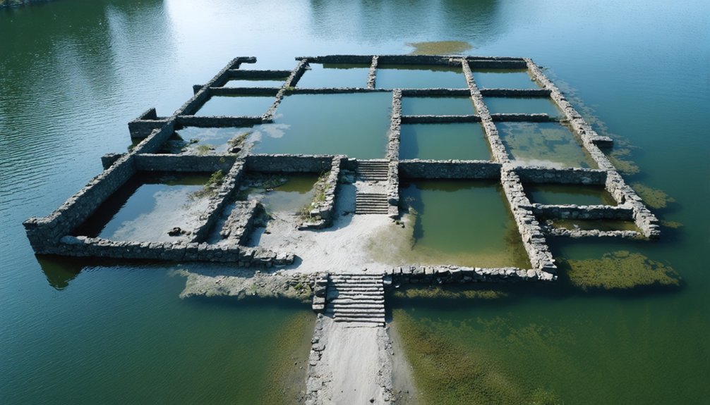
The Drowned Valley: Arena and the Pepacton Reservoir
When New York City condemned the valley in 1954, Arena’s 250-300 residents had no legal recourse to prevent their displacement. The city’s eminent domain authority dictated below-market compensation rates you couldn’t challenge.
By August 1955, your community became a liquidation sale—buildings sold for scrap, grave sites excavated for $15 each. Construction crews systematically erased historical architecture, removing every structure except their headquarters. They stripped all vegetation, leaving only foundations embedded in soil.
Water filled the Pepacton Reservoir that fall, drowning four towns permanently. The 15-mile-long reservoir now holds 140.2 billion gallons, supplying approximately 25% of NYC’s daily water needs. Today’s reservoir ecology thrives where your homes once stood.
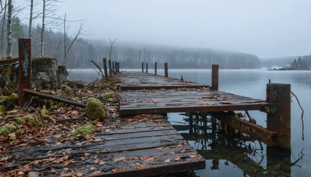
During droughts, receding water exposes archaeological remnants—walls, foundations, debris fields. The most recent historic stretch of bone-dry weather began after September 30th, 2024, when the last measurable rainfall occurred. You’ll find limited access since 2001, though bridges offer views of submerged settlement patterns below.
Bittersweet’s Silent Depths in Neversink Reservoir
If you descend 175 feet below the Neversink Reservoir’s surface along Route 55 in Sullivan County, you’ll reach what remains of Bittersweet—a town that housed 3,000 residents before New York City’s Board of Water Supply ordered its complete demolition in 1941.
The forced displacement of nearly 1,000 people from this specific location culminated on June 4, 1953, when the newly constructed dam flooded the entire valley. Residents faced quick eviction notices nailed to their houses, with some receiving compensation that took up to 2 years to arrive.
The Neversink Reservoir was named after the town of Neversink, which was submerged along with five other towns in the area.
Today, the reservoir supplies over 1,000 million gallons daily to NYC, its waters concealing the foundations, cellar holes, and stone walls of a community that once thrived at Neversink Flats.
3000 Residents Forcibly Displaced
The Board of Water Supply’s 1941 ruling sealed the fate of approximately 3,000 residents who called Bittersweet and the surrounding Neversink area home. You’ll find that 974 people from Neversink alone were forced to abandon their properties, while 2,000 residents watched their community succumb to urban decay.
By August 1913, demolition crews had systematically razed every structure—homes, churches, and bridges—leaving only cellar holes and stone foundations. You can still observe cultural preservation efforts through surviving photographs that document this displacement. When water levels drop significantly, remnants of the original town site occasionally emerge from the depths, including the visible steeple of a submerged church.
The town of Neversink was physically relocated several miles down State Route 55, with workers lifting entire houses off their foundations. The original settlement, founded in 1798, had featured a charming main street complete with a post office, covered bridge, and two-room schoolhouse. By 1953, the reservoir had consumed the original settlement, submerging your historical record beneath millions of gallons destined for New York City’s water supply.
175 Feet Below Surface
Since 1953, Bittersweet’s remains have rested 175 feet beneath the Neversink Reservoir‘s surface, where millions of gallons of water destined for New York City now flow over what were once Main Street, a covered bridge, and a two-room schoolhouse.
This precise depth measurement contradicts urban legends claiming the town sits at various shallow depths. During droughts, you’ll witness actual underwater archaeology when water levels drop—the Methodist chapel’s steeple emerges, stone foundations become visible, and cellar holes reveal themselves.
The reservoir’s 175-foot maximum depth consistently covers demolished structures: homes razed before flooding, relocated cemeteries, and submerged railroad tracks. What remains isn’t speculation—it’s documented infrastructure deliberately flooded after the Board of Water Supply’s 1941 decision, creating Manhattan’s water source 75 miles northwest. Residents were forcibly displaced in the 1930s and early 1940s, their homes sold to make way for the reservoir that would serve the city’s growing water demands. The reservoir now provides over half of NYC’s water supply, delivering approximately 1,000 million gallons daily to residents who remain largely unaware of the town that lies beneath.
Ashokan’s Flooded Hamlets and the Price of Progress
Between 1907 and 1915, construction crews dammed Esopus Creek and cleared 8,315 acres of settled land to create the Ashokan Reservoir, flooding four hamlets and forcing the relocation of eight others.
Eight thousand acres of settled land submerged, displacing entire communities to quench New York City’s thirst for water.
You’ll find West Hurley, Glenford, Ashton, and Shokan now lie 180 feet underwater, while Boiceville, Brodhead’s Bridge, Brown’s Station, Olive, Olive Bridge, Olive City, and West Shokan were displaced.
NYC’s eminent domain seized 12,000 acres, evicting 2,350 residents—some with just ten days’ notice. The government destroyed 500 homes, 35 stores, 10 churches, and 8 mills, compensating families below market value while exhuming 2,500 bodies at $15 per grave.
This urban decay traded established communities for infrastructure, demonstrating significant ecological impact as land settled since the 1700s vanished beneath water supplying 40% of NYC’s demand. Displaced families often hired lawyers to fight for compensation, though courts frequently dismissed claims for generational apple orchards and farms that had sustained communities for decades.
The completed reservoir became the largest in the world at the time, a distinction it held upon its 1915 opening as it transformed the landscape irreversibly.
Five Towns Beneath Cannonsville Reservoir
New York City’s water demands grew insatiable by mid-century, prompting officials to target Delaware County’s West Branch watershed for its next massive reservoir project.
In December 1949, authorities announced plans claiming 19,910 acres across Tompkins and Deposit townships. You’ll find no ancient artifacts or underwater flora exploring this site—engineers scraped it clean before flooding.
Cannonsville, Beerston, Granton, Rock Royal, and Rock Rift vanished completely between 1960-1964. Nearly 1,000 residents faced displacement as bulldozers demolished every structure standing.
Workers relocated 2,123 deceased from eleven cemeteries, most transferred to Pepacton Cemetery. Benjamin Cannon’s 18th-century settlement, once containing his post office and homestead, disappeared without trace.
The reservoir achieved operational status in 1964, creating NYC’s largest drainage basin at 455 square miles—obliterating five communities for municipal water supply.
Rondout, Schoharie, and the Expanding Reservoir Network
The Rondout Reservoir, constructed between 1936 and 1952, submerged three complete communities—Eureka, Montela, and Lackawack—displacing over 250 families to create the central collection point for NYC’s Delaware System.
You’ll find this 49.6-billion-gallon reservoir now supplies half of New York City’s daily water consumption, drawing from three upstream reservoirs through 85 miles of tunnel beneath the Hudson River.
Earlier, the Schoharie Reservoir’s 1916 Gilboa Dam flooded the village of Gilboa and relocated 500 residents, establishing the compensation pattern of lowball property offers that would repeat across subsequent reservoir projects.
Rondout’s Delaware River Connection
Constructed between 1937 and 1954, Rondout Reservoir emerged as the linchpin of New York City’s Delaware System, connecting four reservoirs across a 1,012-square-mile watershed through the world’s longest continuous tunnel.
You’ll find this 85-mile Delaware Aqueduct delivers water from Rondout to West Branch Reservoir in Putnam County, supplying half the city’s daily consumption at 890 million gallons.
The reservoir ecology underwent complete transformation as engineers removed entire communities—Eureka, Montela, and Lackawack—clearing every structure, tree, and even tall weeds to maintain water purity.
This water infrastructure demonstrates centralized control at its extreme: 250 families displaced, property claims slashed below half value, all to serve distant urban demands.
The 49.6-billion-gallon capacity represents prioritized city needs over local autonomy and generational homesteads.
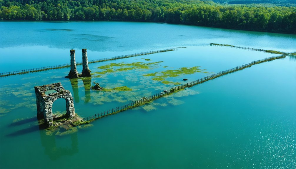
Schoharie’s Submerged Gilboa Village
When New York City’s expanding water demands exceeded Ashokan Reservoir’s 130.5-billion-gallon capacity, engineers targeted Gilboa—a progressive Schoharie Valley village with its own hydroelectric plant, newspaper, and movie theater.
In 1917, eminent domain forced 350 residents from their homes as construction began on the Gilboa Dam.
By 1924, 57 feet of water submerged the entire settlement: churches, schools, businesses, and farms vanished beneath the 1,142-acre Schoharie Reservoir’s surface.
Seven cemeteries required relocation before flooding.
Today, historical preservation efforts face archaeological challenges as overgrown foundations and roads lie hidden underwater.
During droughts, when water levels recede, you’ll glimpse remnants of this confiscated community—tangible evidence of governmental power exercised against individual property rights for collective urban consumption.
When Drought Reveals What Was Lost
The archaeological significance becomes clear when drought reveals what bureaucratic flooding destroyed.
Shavertown, Pepacton, and Union Grove join Arena in temporary resurrection. Meanwhile, New Jersey’s 1800s Ghost Bridge emerges fully exposed, though maintenance—not drought—caused that drawdown.
These revelations demonstrate how state-mandated reservoir projects permanently displaced communities for distant urban water needs.
The Human Cost of New York City’s Water Supply
Between 1940 and the 1960s, New York City’s expanding reservoir system forcibly displaced approximately 3,000 families from their ancestral lands in the Catskill and Delaware regions.
You’ll find that Neversink, Pepacton, Cannonsville, and Schoharie reservoirs erased entire communities—seventeen hamlets vanished under Cannonsville alone, where authorities razed 2,000 buildings.
The government’s eminent domain process undervalued properties, with Pepacton families receiving average compensation of just $10,000 per farm—insufficient for rebuilding elsewhere.
Churches were dynamited, graveyards exhumed, and school districts dissolved.
What remains submerged represents more than infrastructure—it’s a sacrifice zone where urban preservation priorities overrode rural communities’ rights.
Historical archaeology can’t recover what’s lost when cultural memory drowns beneath drinking water, though drought occasionally reveals these ghost towns‘ remnants.
Frequently Asked Questions
Can You Dive or Boat in the Reservoirs Where Towns Are Submerged?
You can’t dive or boat in these reservoirs—they’re strictly off-limits. New York City’s water supply management blocks all recreational diving and boating access, preventing any historical preservation efforts of the submerged towns beneath 30 billion gallons.
Are There Any Artifacts Recovered From the Underwater Ghost Towns?
No artifacts recovery from underwater ghost towns is documented. Historical treasures remain submerged and inaccessible—reservoirs are restricted watersheds where you’re prohibited from diving, making artifact retrieval impossible. The sites exist only as preserved archaeological evidence underwater.
How Deep Are the Reservoirs During Normal Water Levels?
Picture yourself descending through dark waters: reservoir depths vary dramatically from Ashokan’s 190-foot maximum to Hinckley’s 75 feet at normal levels. Safe diving requires understanding these variations—most average 28-46 feet, offering accessible exploration opportunities for certified divers.
Were Residents Fairly Compensated When Forced to Leave Their Homes?
Compensation fairness was questionable—you’d have received fixed sums without negotiation rights. Relocation disputes arose as Ashokan residents got below-market rates, and you’d have had no legal recourse to challenge the city’s eminent domain valuations.
Can Descendants Visit the Sites Where Their Ancestors’ Towns Once Stood?
You can visit reservoir shorelines where ancestral towns stood, but NYC tightly controls access post-9/11. During droughts, exposed foundations offer rare glimpses into sites of cultural significance, though historical preservation remains limited by security restrictions and no-trespassing enforcement.
References
- https://hudsonvalleycountry.com/catskill-podcast-explores-underwater-town-of-athena-new-york/
- https://www.youtube.com/watch?v=BuFTW4OWdLs
- https://archaeology.org/issues/may-june-2024/letters-from/ghost-towns-of-the-ashokan-reservoir/
- https://q1057.com/reservoir-wipes-out-entire-town-of-3000-the-story-of-bittersweet-new-york/
- https://www.atlasobscura.com/places/the-drowned-towns-of-the-ashokan-reservoir
- https://en.wikipedia.org/wiki/List_of_flooded_towns_in_the_United_States
- http://ghostlakes.blogspot.com/2012/02/ashokan-reservoir.html
- https://www.atlasobscura.com/articles/the-final-christmas-of-4-catskills-villages-flooded-to-create-reservoirs
- https://www.untappedcities.com/some-of-nycs-drinking-water-comes-from-drowned-towns-in-the-catskills/
- https://hudsonvalleycountry.com/new-yorks-underwater-town-neversink/