You’ll find at least nine submerged communities beneath North Carolina’s mountain reservoirs, deliberately flooded between 1916 and 1944 for hydroelectric development. Fontana Lake alone covers towns like Judson, Proctor, Forney, and Almond—complete with homes, schools, churches, and 28+ cemeteries—sacrificed when TVA’s 480-foot dam created an 11,000-acre reservoir in 1944. Lake Lure similarly erased the Gold Rush town of Buffalo. During droughts, receding waters expose foundations, bridges, and artifacts from these lost settlements, offering tangible evidence of the communities that wartime energy demands required authorities to sacrifice.
Key Takeaways
- Nine towns including Judson, Proctor, Forney, Almond, and Japan were submerged beneath Fontana Lake during 1944 dam construction.
- Buffalo, a Gold Rush-era town, was completely erased by flooding when Lake Lure was created.
- Fontana Dam displaced 1,200-1,300 families and flooded homes, schools, churches, and 35 cemeteries across 11,000 acres.
- During droughts, receding waters expose foundations, stone pathways, bridges, and artifacts from submerged communities.
- The 480-foot Fontana Dam was built in 35 months to support WWII industries, sacrificing entire mountain communities.
The Drowning of Judson: A Town Beneath Fontana Lake
Before Fontana Dam‘s construction transformed the landscape, Judson functioned as a thriving mountain community of approximately 600 residents along the Tennessee River in Swain County. You’ll find its historical architecture—an elementary school, barber shop, sawmill, and post office—now submerged beneath Fontana Lake’s 135-foot average depths.
The 1940s wartime dam project, completed in 1944 to power aluminum production for military equipment, immediately displaced all inhabitants. Swain County transferred thousands of acres to federal control, flooding homes and infrastructure across 10,000 acres.
Local legends persist about cemeteries remaining underwater, though 243 graves were officially relocated alongside 2,311 displaced families. When water levels drop dramatically, you’re permitted to observe exposed foundations and structures—tangible evidence of this government-mandated community sacrifice for national defense priorities.
Proctor’s Silent Depths: Lost to the Waters of Progress
The Tennessee Valley Authority’s Fontana Dam project displaced 1,200 families from Proctor and three neighboring communities, creating a 29-mile reservoir that permanently altered Swain County’s geography.
You’ll find that the federal government’s unfulfilled 1943 promise to construct a replacement access road resulted in only seven miles of pavement—the infamous “Road to Nowhere”—leaving former residents dependent on National Park Service ferry boats to reach 26 submerged cemeteries.
This infrastructure failure stands as North Carolina’s most documented case of eminent domain displacement, with Proctor remaining the sole town above Fontana Lake’s high water mark on the northern shore.
The dam’s construction served to generate electricity for weapons labs supporting the Allied war effort during World War II.
Founded in 1886, Proctor had evolved into a thriving logging community complete with schools, theaters, and churches before most structures were demolished to make way for the reservoir.
Road to Nowhere Legacy
When federal authorities signed the July 30, 1943 agreement with Swain County, they committed to constructing a 30-mile road connecting Bryson City to Fontana Village around Fontana Lake’s northern perimeter.
The Tennessee Valley Authority’s $400,000 payment compensated for flooding Highway 288, while the National Park Service acquired 44,000 acres along the north shore.
You’ll find only six miles of Lakeview Drive completed today—a fragment halted by unstable rock formations and mounting environmental concerns.
The 1983 court ruling released Interior from obligation without congressional appropriations, yet historical preservation demands clashed with ecological impact realities.
A 2007 NPS environmental impact study concluded the area too fragile for road construction, citing concerns over sensitive terrain and ecosystem disruption.
The 2010 settlement delivered $52 million to Swain County, approximating completion costs while protecting sensitive terrain.
The area’s 35 cemeteries remain accessible solely by boat or arduous overland routes, commemorating 1,300 displaced families whose promised access never materialized.
The North Shore Cemetery Association now decorates and maintains 28 of these cemeteries, continuing efforts that began in the 1970s to preserve these sacred grounds.
Four Towns Now Submerged
Deep beneath Fontana Lake’s surface, Proctor’s submerged remnants tell a contradictory story—one where progress demanded sacrifice yet failed to deliver on its promises.
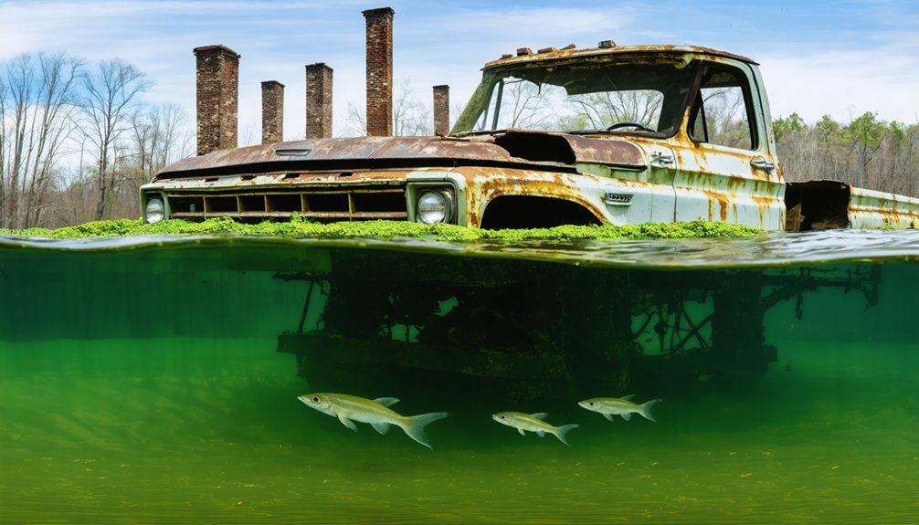
You’ll find mine offices and portions of communities buried under water—casualties of the 1943-1944 dam construction that displaced 1,200 families. The Tennessee Valley Authority flooded dozens of settlements to power aluminum production, washing out Highway 288 and isolating survivors.
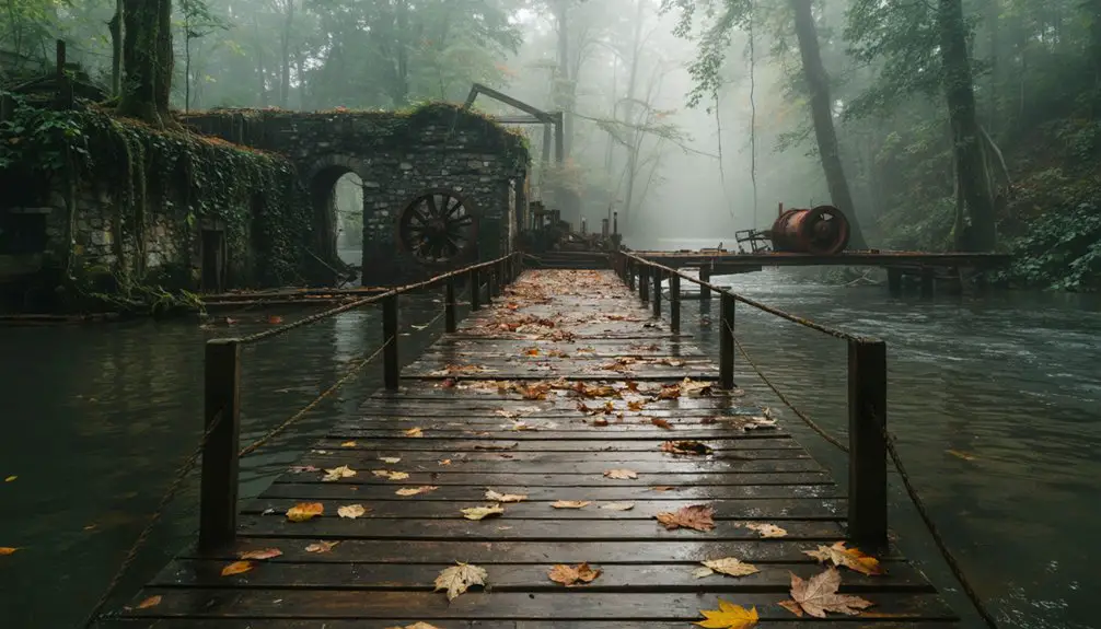
Historical preservation became impossible for structures below the waterline. The Ritter Lumber Mill, once the economic heart of this thriving company town, now lies among the submerged ruins. Above water, moss-covered chimneys and stone foundations mark where homes once stood. The environmental impact extended beyond physical submersion: the government’s broken promise of replacement road access—halted after seven miles—left descendants unable to reach ancestral homesites.
While Proctor’s cemetery and upper sections survived above the high water mark, the flooded remnants represent authoritarian overreach disguised as wartime necessity.
Buffalo’s Watery Grave: Lake Lure’s Submerged Secret
- Infrastructure remnants: Multibeam echosounder sonar identified a submerged bridge and roadway at the lake’s center during hydrographic surveys.
- Mechanical equipment: Abandoned devices stripped of usable parts before inundation.
- Intact watercraft: 32-foot boat “Pooh Bear” discovered with legible bow markings.
- Community displacement: Complete relocation included homes, church materials, cemetery graves, and Ledbetter Store. The Rocky Broad River was impounded at Tumbling Shoals to create the 720-acre lake with 27 miles of shoreline. Buffalo was a Gold Rush era town that now lies approximately 50 feet underwater.
This government-sanctioned flooding erased Buffalo from historical records entirely.
Fontana Dam: Engineering Marvel and Community Destroyer
You’ll find World War II’s insatiable demand for aluminum production and atomic research directly caused the Tennessee Valley Authority to construct Fontana Dam in just 35 months, generating 293.6 megawatts to power Oak Ridge’s Manhattan Project facilities.
This engineering achievement—utilizing 2.8 million cubic yards of concrete to create the Eastern United States’ tallest dam at 480 feet—came at the cost of nine complete communities.
The reservoir’s impoundment beginning November 7, 1944, permanently submerged Proctor, Forney, Almond, Japan, Judson, Bushnell, Tuskeegee, Wayside, and Welch beneath Fontana Lake‘s 11,000 acres.
Wartime Power Generation Needs
Within nine days of the Pearl Harbor attack, Congress authorized the Tennessee Valley Authority to construct what would become the highest dam in the eastern United States—a 480-foot concrete barrier designed not for peacetime prosperity but for wartime survival.
The strategic imperative was clear:
- Aluminum Production: Aircraft manufacturing demanded unprecedented electrical capacity, driving agricultural decline as farmland disappeared beneath rising waters.
- Manhattan Project Support: Oak Ridge National Laboratory required massive power to produce uranium-235 for America’s first atomic bomb.
- Accelerated Timeline: 6,000 workers laboring in three shifts, seven days weekly, completed construction in thirty-five months—half the peacetime duration.
- Operational Achievement: First generators activated January 1945, delivering 202.5 megawatts while obliterating cultural preservation efforts in mountain communities.
The cost: $74.7 million and fourteen lives.
Communities Lost to Progress
As Fontana Dam’s concrete reached its record-breaking 480-foot height—2,365 feet long and 376 feet thick at its base—nine communities along the Little Tennessee River faced systematic erasure. Proctor, Forney, Almond, Japan, Bushnell, Judson, Tuskeegee, Wayside, and Welch disappeared beneath the 11,000-acre reservoir‘s 240-mile shoreline.
You’ll find no archaeological surveys documented their cultural heritage before inundation. The $74.7 million project prioritized wartime electricity generation over 6,000 workers’ three-shift schedules rather than community preservation.
Environmental impacts extended beyond submerged towns—over 40,000 acres transferred to Great Smoky Mountains National Park, thousands more to U.S. Forest Service control. The accelerated 35-month construction timeline left displaced residents minimal relocation time, demonstrating how national security imperatives override individual property rights and established settlement patterns.
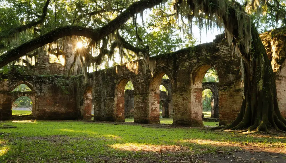
When the Waters Recede: Glimpsing the Ruins Below
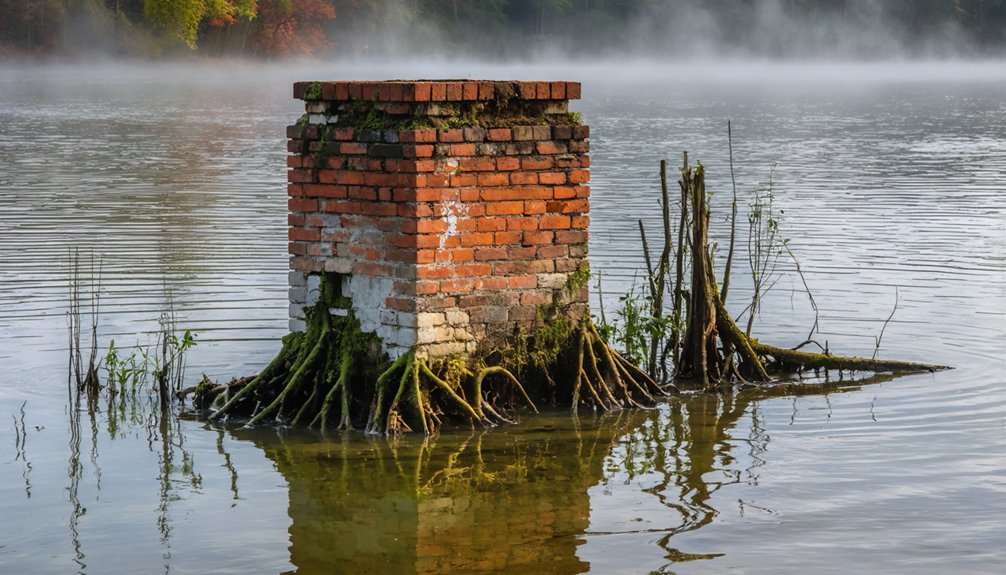
When drought conditions drop reservoir levels below their operational thresholds, North Carolina’s submerged communities resurface with striking clarity. You’ll witness aquatic archaeology emerging from decades of submersion, revealing structural evidence that standard documentation methods can’t capture.
The exposed landscapes transform into accessible research sites where submerged flora recedes to reveal human settlement patterns.
Observable remnants include:
- Stone pathways and foundations at Jordan Lake’s New Hope Valley, connecting domestic structures through deteriorating roadways
- Judson town structures at Fontana Lake’s highest elevations, accessible during authorized drawdown periods
- Railroad spikes and pottery fragments scattered across exposed lake beds, documenting industrial activity
- Bridge supports from Highway 150 and Beattie’s Ford, marking original transportation infrastructure
Pontoon boats enable closer examination when water clarity permits visual penetration of remaining submerged sections.
Wartime Demands and the Price of Power
World War II’s industrial mobilization transformed North Carolina’s landscape through hydroelectric infrastructure development that prioritized national defense over local communities.
War’s energy demands reshaped entire communities, sacrificing local heritage for the urgency of national defense production.
You’ll find Fontana Dam, completed in 1944 as the tallest structure east of the Rockies, generated power for aircraft, munitions, and ships while submerging Judson and displacing 600 residents.
The government seized private land throughout the 1930s-1940s, flooding thousands of acres for wartime energy needs.
Historical architecture vanished beneath reservoir waters as families received inadequate compensation for their seized properties.
Cultural preservation took a backseat to military urgency—family cemeteries became accessible only by ferry, looters stripped abandoned homes of treasures, and entire communities disappeared.
The $52 million settlement paid to Swain County in 2018 acknowledged these forced sacrifices decades later.
The Road to Nowhere: Broken Promises to Displaced Families

On July 30, 1943, federal officials pledged a 30-mile road around Fontana Lake’s northern shore to Swain County residents—a promise intended to compensate for the flooding of Highway 288 and restore access to submerged communities and cemeteries.
The National Park Service accepted construction responsibility while TVA paid $400,000 for the lost highway.
What Actually Happened:
- Construction stalled in 1971 after just six miles when unstable rock and environmental impact concerns halted progress.
- Historical preservation failed as thirty-five cemeteries remained inaccessible without boat transport.
- Legal battles persisted until a 2010 settlement paid Swain County $52 million.
- The unfinished “Road to Nowhere” stands as testimony to governmental promises broken, restricting your freedom to access ancestral lands.
Current $15.7 million reconstruction plans can’t restore what disappeared beneath Fontana’s waters.
Exploring the Underwater Ruins Today
During scheduled drawdowns of Fontana Lake, you can observe foundations, gravestones, and structural remnants of Judson emerging from receding waters. You’ll need permission to access these sites, though pontoon boats allow observation of submerged ruins through clear water between drawdowns.
For direct exploration, technical diving operations reach structures like Whitewater Bridge and Attakulla Lodge beneath Lake Jocassee’s 300-foot depths, where marine archaeology principles guide documented expeditions. Dive shops in the region offer guided underwater photography sessions of these ghost towns, providing unregulated access to sites bureaucrats intended to bury forever.
The Great Smoky Mountains Railroad’s Nantahala Gorge Excursion offers aerial perspectives of four intentionally flooded communities. Lake Lure’s 2024 drawdown—first since 1927—exposed Buffalo’s schoolhouse and building outlines, though authorities closed access through summer 2025.
Frequently Asked Questions
Are There Other Submerged Towns in North Carolina Besides These Three?
Yes, you’ll find several more submerged towns beyond those three. Lake Norman, Jordan Lake, and Falls Lake each hide communities sacrificed for reservoir construction, demonstrating historical preservation challenges and significant ecological impact from North Carolina’s mid-20th-century dam-building initiatives.
Can Scuba Divers Legally Explore the Underwater Ruins Without Special Permission?
You’ll find no legal restrictions or permit requirements for diving Fontana Lake’s submerged ruins. TVA regulations allow public access without special permission, though you must follow standard boating and water safety protocols during your exploration.
Were Residents Compensated Fairly When Their Towns Were Flooded?
Compensation disparities plagued these relocations. You’ll find documented evidence that families deemed payments inadequate, particularly at Jordan Lake where 1964 records show residents protested compensation not reflecting predicted land values. Relocation controversies centered on systematic undervaluation of generational homesteads.
What Happened to Bodies in Cemeteries Before the Towns Were Submerged?
You’ll find burial practices weren’t systematically documented before flooding. Bodies generally remained in place, creating ongoing preservation challenges. Government records lack thorough exhumation data, leaving families to navigate restricted access to submerged ancestral graves independently.
How Deep Underwater Are the Ruins of Each Ghost Town?
You’ll find depths vary dramatically: Jocassee’s Attakulla Lodge sits beneath 300 feet, while Fontana’s Judson occasionally surfaces during drawdowns. Historical preservation and diving regulations restrict access to most sites, though technical divers can explore Jocassee’s documented structures independently.
References
- https://www.onlyinyourstate.com/state-pride/north-carolina/judson-nc-underwater-ghost-town
- https://www.thewanderingappalachian.com/post/the-underwater-towns-of-appalachia
- https://wisenewsnetwork.com/stories/underwater-town-found-in-western-north-carolina
- https://www.blueridgeoutdoors.com/go-outside/sunken-secrets-the-underwater-ghost-towns-of-the-blue-ridge/
- https://avltoday.6amcity.com/remembering-judson-wncs-underwater-ghost-town
- https://www.youtube.com/watch?v=2CE3cdihJ0Y
- https://hiddenhistorian.com/adventures/f/underwater-ghost-town-century-old-ruins-appear-under-lake-lure
- https://www.islands.com/1977921/proctor-north-carolina-great-smoky-mountains-ghost-town-war-history-fishing-destination/
- https://wlos.com/news/local/north-carolina-fontana-lake-proctor-town-submerged-underwater-history-100-years-ancestors-families-shorelines-world-war-2-lee-woods-historian
- https://www.atlasobscura.com/places/proctor-lost-ghost-town-hazel-creek