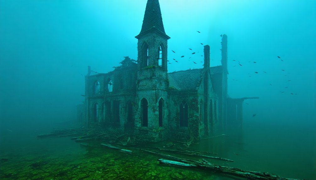
You’ll find at least six documented Ohio communities now submerged beneath reservoir waters, including Atwood (flooded 1936 for the Muskingum Watershed Conservancy District dam), Claylick (submerged under Cave Run Lake 1965–1973), and Elk Lick (beneath William H. Harsha Lake since 1978). The catastrophic 1913 flood, which destroyed Hooksburg and killed nearly 500 people, triggered systematic flood control infrastructure that deliberately sacrificed entire townships. Divers now explore lumber mill remnants, relocated cemeteries, and foundations where 50+ buildings once stood—archaeological evidence of communities displaced by engineered waterways that’ve prevented over $10.7 billion in subsequent damages.
Key Takeaways
- Atwood was entirely submerged in 1936 after dam construction, with residents and cemeteries relocated beforehand for flood control purposes.
- Hook’sburg was destroyed and flooded in 1913 after catastrophic rainfall, obliterating structures and permanently altering waterways in the region.
- Blackburn disappeared before 1950, now submerged under Burr Oak Lake with remains occasionally visible due to fluctuating water levels.
- Claylick in Kentucky shares similarities; it was submerged by Cave Run Lake after lumber operations ceased in 1913.
- Ohio’s 1913 flood killed nearly 500 people, prompting massive dam projects that intentionally submerged towns for flood control.
Blackburn: A Methodist Settlement Lost to Progress
Before Burr Oak Lake claimed the valleys of Morgan County in 1950, the Methodist settlement of Blackburn had already vanished from Ohio’s landscape. You’ll find its former post office site submerged beneath waters covering William A. Shepard‘s large farm, positioned near Union Township’s southern border.
This Methodist community centered around a church on the Shepard property, where both William (1842–1924) and Georgia Peddicort Shepard (1844–1915) established their homestead before relocating to Franklin County.
Unlike typical reservoir-displaced towns, Blackburn’s abandonment preceded the lake’s construction by decades. The settlement included Union Township No. 9, a school located on the Blackburn farm owned by William Wesley Acker. The Shepard family’s departure marked the settlement’s decline, leaving only abandoned farmland. Fluctuating water levels have periodically exposed and concealed the settlement’s foundations over the decades.
Today, Vicksville occupies the former homestead site, while some Blackburn residents rest in Fairview Cemetery. Their graves stand as tangible evidence of this forgotten Methodist community.
Hooksburg: Captain Hook’s River Town Swept Away in 1913
Hook’s 1906 gravestone reveals his understanding of flood preparedness—he placed a small boat atop it so he could “row away if it flooded.”
His premonition proved prophetic. The Great Flood of 1913 released 6–11 inches of rain over five days, partially destroying Hooksburg and washing away both church and gravestone, demonstrating nature’s supremacy over human settlement. The catastrophe damaged 69 bridges across the Muskingum River Watershed alone, crippling transportation throughout the region. Like Utopia’s devastating 1847 flood that claimed 150 of 156 citizens, the 1913 deluge forever altered Ohio’s riverside communities.
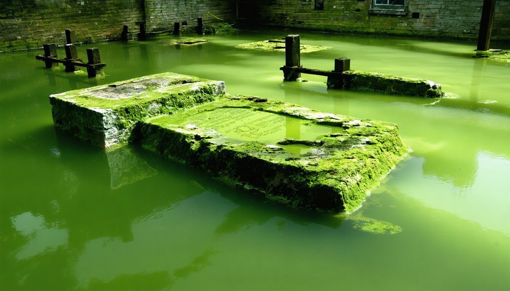
Claylick: Ohio’s Largest Town Destroyed by Repeated Flooding
You’ll find Claylick’s history rooted in southeastern Bath County, Kentucky—not Ohio—where the Licking River’s strategic position enabled Sterling Lumber Company to establish a 32-mile narrow-gauge railroad terminus connecting to the Chesapeake and Ohio line at Salt Lick.
The community’s destruction resulted primarily from the 1913 sale and dismantling of Yale Lumber Company operations rather than catastrophic flood events, though chronic flooding in the lower Licking River valley accelerated abandonment.
Cave Run Lake’s construction between 1965 and 1973 by the U.S. Army Corps of Engineers ultimately submerged the former townsite as part of regional flood control infrastructure. The submerged town remnants remain visible to divers exploring what was once a thriving lumber community. Similarly, Tappan Lake in Harrison County conceals the forgotten village of Laceyville beneath its 2,350-acre surface after dam construction in 1936 flooded the community.
Strategic River Location
Claylick’s position along the Licking River in southeastern Bath County placed it at a critical junction of Ohio’s river commerce network, yet this same location sealed its fate as the state’s largest town destroyed by repeated flooding.
You’ll find the settlement occupied strategic terrain where the narrow-gauge railroad connected to the Chesapeake and Ohio at Salt Lick, enabling efficient lumber transport to broader markets. However, the lower Licking River valley‘s topography channeled upstream runoff directly through town, accelerating river erosion that undermined structures with each inundation.
Without modern flood mitigation infrastructure like Cave Run Lake—constructed decades later—Claylick remained defenseless against cyclical disasters. The catastrophic 1913 flood proved terminal, forcing Yale Lumber Company’s exodus and eliminating the economic foundation that justified continued occupation. The floodwaters reached five feet deep on town roads as residents evacuated to higher ground on surrounding hills to escape the rising waters.
Twin Floods’ Devastating Impact
Between 1900 and 1913, Claylick endured two catastrophic flood events that systematically dismantled the town’s physical and economic infrastructure. The Licking River’s initial overflow destroyed homes, mills, and farms, halting commerce entirely.
You’ll find the second mid-1910s deluge exceeded the first in volume, collapsing remaining structures and rendering agricultural lands unusable through silt deposition. Over 50 buildings were demolished, including Yale Lumber Company facilities.
The geological formations channeling floodwaters through this narrow valley proved fatal—no federal intervention existed to counter nature’s assault. Cultural influences from Appalachian self-reliance couldn’t overcome repeated inundation.
Population plummeted from several hundred to zero as residents permanently abandoned the site. The 32-mile railroad submerged, six graveyards relocated, and economic activity ceased. Similar to Buck Run’s post office operations that ended in 1904, essential services disappeared as infrastructure collapsed.
Claylick became Ohio’s largest flood-destroyed settlement.
Atwood: Sacrificed for Flood Control and Lake Creation
Unlike Claylick’s abandonment due to natural flooding, Atwood’s submersion resulted from deliberate engineering intervention by the Muskingum Watershed Conservancy District.
You’ll find this Carroll County settlement was systematically abandoned in 1936 when authorities completed a 20-meter-high, 1,128-meter-long dam across the Indian Fork River, creating a 6.2-square-kilometer reservoir.
The project relocated an entire farming community—including residents, infrastructure, and even cemetery remains—to prevent flood disasters like the catastrophic 1913 event that killed over 1,000 people statewide.
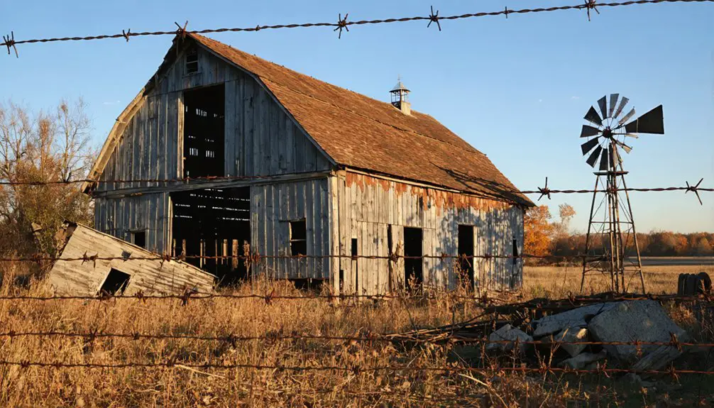
Before its submersion, the town featured essential community services including a general store, multiple churches, a blacksmith shop, and a school that served local families.
The Atwood reservoir was part of Arthur Morgan’s master plan that included 15 dams and reservoirs designed to manage water across the watershed’s 8,000 square miles.
Carroll County Town Abandoned
When the Muskingum Watershed Conservancy District completed the Atwood Dam in September 1936, the unincorporated settlement of Atwood vanished beneath the waters of the newly formed reservoir.
This Carroll County community, established along the Indian Fork River in the early 1800s by Virginia transplant John Shober, had functioned without formal incorporation for over a century.
The 20-meter-high, 1,128-meter-long dam sacrificed a town that once supported essential infrastructure: a post office, Wheeling & Lake Erie Railroad station, store, blacksmith shop, school, and town hall.
Urban decay never claimed Atwood—deliberate flooding did.
Historical preservation efforts manifested through two protected cemeteries and a dedication plaque at State Route 542 and Fargo Road, ensuring residents’ freedom to honor ancestral connections despite the settlement’s submersion.
Atwood Lake Flood Control
The Muskingum Watershed Conservancy District engineered the Atwood Dam as a 20-meter-high, 1,128-meter-long flood control structure at a construction cost of $1,403,900, completing the project in September 1936.
You’ll find this historical engineering achievement emerged from the catastrophic 1913 flood that killed nearly 500 people and caused $300 million in property damage.
The 1939 Flood Control Act transferred operational control to the U.S. Army Corps of Engineers, establishing federal authority over flood mitigation while MWCD maintained recreation facilities.
The reservoir’s design accommodates flows 36% larger than the 1913 storm event, with a peak capacity of 6,100 cubic feet per second.
This infrastructure has prevented over $10.7 billion in damages, though ecological impacts included submerging communities and transforming watershed ecosystems permanently.
Residents Relocated for Infrastructure
Engineering Atwood Dam required removing approximately 50 households from their ancestral lands, as construction specifications permitted no permanent structures within the designated flood pool zone. You’ll find that governmental authority superseded private property rights when the Muskingum Watershed Conservancy District initiated forced relocation in 1936.
Urban decay accelerated as residents abandoned commercial establishments, the operating school, and civic infrastructure before reservoir flooding commenced.
The displacement process involved:
- Mandatory evacuation of families from farming operations predating the 1820s settlement period
- Archaeological preservation efforts for cemetery relocations, though grave transfer documentation remained incomplete at Big Spring and Zion sites
- Zero compensation protocols for intangible losses including community dissolution and severed generational connections to land
The 6.2-square-kilometer reservoir permanently submerged what residents couldn’t relocate.
Elk Lick: Submerged Beneath William H. Harsha Lake
Nestled in southeastern Batavia Township along the East Fork of the Little Miami River, Elk Lick once occupied a strategic position in Clermont County’s settlement geography approximately four miles south of Batavia, Ohio.
The community developed around Donnells Trace’s river crossing, later experiencing brief prosperity during 1868’s gold rush when Samuel Atchley discovered gold on Robert Wood’s farm.
William H. Harsha Lake’s creation between 1970-1978 erased this settlement from Ohio’s landscape.
Archaeological findings documented before inundation included two gold mines—one featuring a 400-foot flume and another tunnel operation near Twin Bridges Road.
The Miami Purchase Association preserved the Elk Lick House by relocating it to Heritage Village Museum.
Today, hydroelectric development and flood control have replaced this community, leaving only Elk Lick Road as commemorative evidence.
Sprucevale: Canal Era Remnants Along the Sandy and Beaver
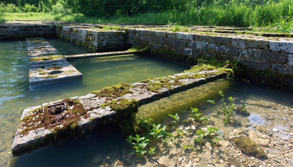
Founded in 1837 along the Sandy and Beaver Canal, Sprucevale emerged as a transportation-dependent settlement in what’s now Beaver Creek State Park, Columbiana County. You’ll find this ghost town’s canal remnants accessible via wilderness trails, including Hambleton’s Mill ruins, Gretchin’s Lock stonework, and a partially submerged cotton mill.
The canal operated briefly from 1848-1852 before engineering failures—insufficient water infrastructure and missing aqueducts—doomed commercial viability. Final residents departed by 1870.
Key Site Features:
- Lock No. 36: Parallels Little Beaver Creek with interpretive markers documenting 1828-1848 construction timeline.
- Structural Remains: House foundations, bridge crossings, and mill ruins with visible graffiti modifications.
- Ghost Legends: Gretchin (1837 malaria victim), Esther Hale (spurned bride), and Pretty Boy Floyd (1934 shooting) narratives documented through folklore investigations.
You’ll navigate reclaimed coal-strip landscapes, now reforested, at coordinates 40.708519, -80.576598.
Frequently Asked Questions
Can You Scuba Dive or Explore the Submerged Towns Underwater Today?
You can’t legally dive these submerged ghost towns—they’re off-limits. Underwater archaeology sites lack public scuba diving safety protocols, and authorities restrict access. Your freedom to explore ends where flood control infrastructure and preservation regulations begin, unfortunately.
Historic ghost towns in Tennessee hold untold stories beneath the waters, waiting to be discovered by historians and curious adventurers alike. While the underwater sites remain hidden from view, the land above continues to attract visitors eager to learn about the history and lore of these once-thriving communities. Exploring the remnants of these towns offers a glimpse into the past, provoking thoughts about the lives once lived in these now-desolate locations.
Were Residents Compensated When Forced to Relocate From These Flooded Towns?
Compensation policies varied considerably across Ohio’s flooded towns. You’ll find MWCD offered modest relocation payments in the 1930s, though relocation challenges meant some residents couldn’t retrieve belongings before flooding began, revealing inconsistent governmental accountability.
Are There Any Artifacts or Remains Still Visible Above Water Levels?
You’ll find Sprucevale’s canal locks remain visible above water, offering rare archaeological discoveries for historical preservation. However, Atwood, Claylick, and Blackburn’s artifacts lie submerged, with only Fairview Cemetery’s graves accessible above Burr Oak Lake’s surface.
How Many Total Ohio Towns Have Been Submerged by Dam Projects?
You’ll find only five confirmed dam-submerged Ohio towns documented: Laceyville, Tappan, Atwood, Elk Lick, and Claylick. However, complete historic preservation records weren’t maintained, so the actual environmental impact likely affected more communities than currently verified.
Can Water Levels Drop Enough to Reveal the Original Town Foundations?
No documented cases exist where you’ll find ancient ruins exposed in Ohio’s reservoirs. MWCD operations maintain water levels for flood control, preventing full drawdowns that would reveal historical snapshots of submerged town foundations beneath managed lakes.
References
- https://ohioghosttowns.org/morgan-county/
- https://www.thewanderingappalachian.com/post/underwater-ghost-towns-of-appalachia
- https://wrkr.com/ohio-ghost-towns/
- https://en.wikipedia.org/wiki/List_of_ghost_towns_in_Ohio
- https://www.youtube.com/watch?v=ONB5GV9T-GI
- https://www.youtube.com/watch?v=bGIHllVn8uE
- https://www.onlyinyourstate.com/state-pride/ohio/abandoned-underwater-town-oh
- https://ohioghosttowns.org/county-data-charts/
- http://librarybooklists.org/mybooklists/drownedtowns.htm
- https://www.youtube.com/shorts/M2OPNiydCe0