Oregon’s submerged ghost towns include seven complete communities lost to reservoir construction and coastal erosion between 1926 and 1958. You’ll find Celilo Falls and its Native villages beneath The Dalles Dam‘s reservoir since March 1957, while Robinette lies 100 feet underwater in Brownlee Reservoir. Six settlements—Landax, Eula, Lawler, Signal, Reserve, and Carter—disappeared beneath Lookout Point Lake’s 35-mile expanse. Bayocean Resort, once promoted as the “Atlantic City of the West,” now rests buried under Tillamook Bay following catastrophic erosion and a 1952 storm breach that permanently transformed the landscape.
Key Takeaways
- Celilo Falls submerged in 4.5 hours on March 10, 1957, flooding Wyam and S’kin communities after The Dalles Dam gates opened.
- Six towns—Landax, Eula, Lawler, Signal, Reserve, Carter—lie completely submerged beneath Lookout Point Lake’s 35-mile reservoir since the 1950s.
- Robinette rests 100 feet beneath Brownlee Reservoir since 1958, with only archival photographs documenting the town before submersion.
- Detroit was submerged by Detroit Dam’s reservoir in 1953 after residents relocated in 1952 following Army Corps land acquisition.
- Klamath Junction submerged beneath Emigrant Lake near Ashland, often confused with Brownlee Reservoir due to geographic inaccuracies in research.
Klamath Junction: Lost to the Brownlee Reservoir
The historical record contains a significant error regarding Klamath Junction‘s submersion. You’ll find Klamath Junction erroneously listed as lost to Brownlee Reservoir, but evidence proves otherwise.
Dam construction on the Snake River at the Idaho-Oregon border created Brownlee Reservoir beginning in 1955, flooding only Snake River communities like Robinette, Oregon. Reservoir formation never reached Klamath Junction, which sits near Ashland on Emigrant Creek—over 250 miles from Brownlee’s location at 44°50′10″N 116°54′00″W. The dam’s catchment area spans 72,590 square miles across the upper Snake River basin.
Klamath Junction’s actual submersion resulted from Emigrant Lake’s expansion, a completely separate project. Emigrant Lake was created in 1926 for irrigation of Rogue Valley farms. This documentation error conflates two distinct reservoirs and geographic regions.
When researching submerged communities, you’re entitled to accurate site-specific information that respects historical facts and geographic reality.
Celilo Village: A Native American Community Displaced
When The Dalles Dam’s floodgates closed at 10:00 a.m. on March 10, 1957, reservoir waters submerged Celilo Falls—located at river mile 204 on the Columbia River—in just 4.5 hours.
This action eliminated North America’s largest waterfall by volume and the sixth largest worldwide.
At least 10,000 witnesses gathered as Celilo Lake formed, flooding Celilo Village and nearby communities Wyam and S’kin.
The Yakama, Warm Springs, Umatilla, and Nez Perce tribes lost fishing sites that had sustained them for over 10,000 years.
Native traditions describe the falls as remains of the Swallow Sisters’ dam, destroyed by Coyote.
Despite federal compensation preserving 1855 treaty rights, fishery decline shattered the economic foundation of these communities.
Chief Tommy Thompson led opposition, but the government’s development agenda prevailed.
The falls had served as a major trading hub where tribes from British Columbia to California and the Great Plains gathered during salmon runs to fish, trade, socialize, and gamble.
Fishers stood on rocks or wooden platforms and used dip nets attached to hoops extending 20 feet or more to capture salmon from the churning waters below.
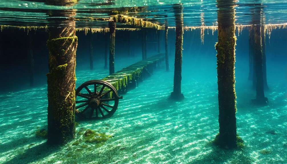
Lookout Point Towns: Six Communities Beneath the Lake
While Columbia River tribes confronted displacement from ancient fishing grounds, another wave of submersion was already underway 200 miles south in Oregon’s Cascade foothills. You’ll find six communities drowned beneath Lookout Point Lake: Landax, Eula, Lawler, Signal, Reserve, and Carter.
The U.S. Army Corps of Engineers completed the 276-foot dam in the early 1950s, impounding 477,700 acre-feet across 35 miles of shoreline. These towns maintained independent grade schools until 1940, demonstrating community resilience before consolidation at Lowell.
Wooden structures likely disappeared, but cement foundations remain beneath silt at depths reaching 534 feet. Unlike towns such as Lowell where residents received compensation or relocation assistance, these six communities were completely razed before flooding, leaving only submerged remnants. Trees and structures were demolished to prevent downstream damage from debris, a common practice that caused emotional distress among former residents. The reservoir generates 120,000 kilowatts while providing flood control—drowning history for hydroelectric power.
Water drawdowns expose this submerged landscape seasonally, revealing traces of Middle Fork Willamette River settlements sacrificed for regional development.
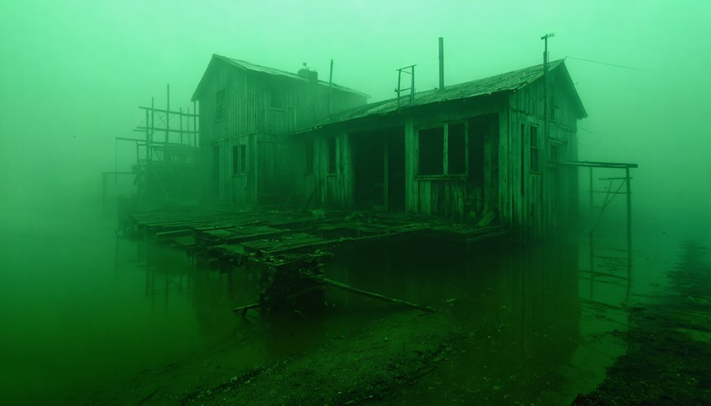
Bayocean Resort: From Vacation Paradise to Buried Ruins
You’ll find Bayocean Resort’s transformation from Oregon’s “Atlantic City of the West” to submerged ruins spans just four decades of documented development and destruction.
The Potter family’s 1906 project featured a natatorium with a 160-foot heated pool, hotels, and 600 sold lots before the 1914-1917 north jetty construction triggered accelerating erosion from 1 foot to 50 feet annually.
Storm-driven breaches in 1952 and subsequent inundation buried the resort’s infrastructure underwater, where archaeological remnants now rest beneath Tillamook Bay’s stabilized spit. The breach allowed ocean water to flood into Tillamook Bay, destroying not only the resort structures but also the area’s oyster farms.
The U.S. Army Corps of Engineers constructed a breakwater in 1956 to protect remaining bay industries, ultimately stabilizing the spit but marking the definitive end of Bayocean as a habitable location.
1920s Vacation Spot Development
In 1906, Thomas Irving Potter’s vision transformed a remote sand spit into what developers boldly marketed as the “Atlantic City of the West.” After convincing his parents to finance the venture, Potter partnered with Harkness Lucius Chapin to form the Potter-Chapin Realty Company in May 1907, establishing Portland headquarters and purchasing the original homesteads on Tillamook Spit.
You’ll find that aggressive marketing campaigns launched in July 1907 sold lot contracts throughout the Pacific Northwest. The four-mile sand spit’s 100-foot ridgeline offered dual views of bay and ocean—perfect for an exclusive resort.
Developers constructed a centerpiece natatorium with a 160-foot heated saltwater pool featuring a wave machine, alongside a grand hotel, bowling alley, and dance pavilion. Streets were surveyed and graded by 1911, with concrete paving already covering half of the roads to accommodate the growing resort community. By 1914, approximately 1,600 lots had been sold, marking the peak of Bayocean’s initial development phase as homes and cottages began appearing across the landscape. Today, marine archaeology efforts document these submerged structures, attracting underwater tourism interest in Oregon’s coastal ghost towns.
Ocean Erosion and Storms
Though developers celebrated the completion of the north jetty at Tillamook Bay’s mouth in 1917, the U.S. Army Corps of Engineers’ single-jetty design immediately disrupted natural littoral sand transport.
You’ll find evidence of coastal erosion beginning at one foot annually, accelerating to fifty feet yearly by the 1940s.
The first cottage succumbed in 1927, with storm breaches transforming the spit into a temporary island throughout the 1920s.
By 1932, the natatorium’s foundation collapsed as ocean waves consumed the 100-foot ridgeline.
Today’s marine archaeology reveals how jetty extension in 1931 intensified shoreline retreat, with structures toppling directly into the sea.
Winter gales drove waves across the narrowing peninsula, ultimately burying Bayocean beneath sand and surf.
Final Destruction and Burial
By 1932, structural collapse reached catastrophic proportions as the natatorium’s west wall foundation gave way completely, marking Bayocean’s shift from deteriorating resort to active demolition site.
You’ll find no historical preservation efforts saved oceanfront cottages as they tumbled into advancing waves or were abandoned to nature’s reclamation.
The 1952 breach delivered the final blow—saltwater inundation destroyed Tillamook Bay’s oyster farms while winter storms crashed across the remaining settlement.
Though the Corps of Engineers’ 1956 breakwater restored spit stability, Bayocean’s infrastructure lay buried beneath accumulating sediment.
Today you’re exploring pristine coastal lands where environmental impacts erased an entire town.
Only the name survives this complete transformation from exclusive destination to naturally-recovered peninsula.
Detroit and Coe: Railroad Towns Claimed by the Dam
Colonel T. E. Hogg’s Oregon Pacific Railroad established Coe in 1889 as a work camp, with Detroit developing alongside these rail efforts in the North Santiam River area. Three mills sustained these railroad towns through timber operations until A.B. Hammond’s 1934 death and the Great Depression collapsed both industries.
The United States Army Corps of Engineers acquired 3,580 acres in 1946 for flood mitigation purposes, forcing Detroit’s 200 residents to relocate in 1952. Detroit Dam’s June 1953 completion—fifth largest in the U.S.—inundated Old Detroit beneath the reservoir.
The 2015 drought exposed archaeological preservation opportunities when Deputy Dave Zahn discovered an 1870s wagon in pristine condition. Low oxygen levels preserved artifacts buried under silt, though authorities concealed locations to prevent looting until water returned.
Robinette: Completely Submerged With No Trace Above Water
Unlike Detroit and Coe, where remnants occasionally surface during low water, Robinette lies 100 feet beneath Brownlee Reservoir’s surface with no visible traces above water since the 1958 flooding.
The townsite’s complete submersion—including all foundations, structures, and the former railroad terminus—represents the most thorough erasure of any Oregon settlement by dam construction.
Pete Basche’s photographic documentation now provides the primary visual record of this Baker County railroad community that served Pine Valley and Eagle Valley before Idaho Power Company’s Brownlee Dam submerged it entirely.
Total Submersion Details
When Brownlee Dam’s construction concluded in 1958, the Snake River’s backed-up waters submerged Robinette completely, erasing all surface evidence of the town that once served as a railroad junction along the Oregon-Idaho border.
The reservoir buried the entire townsite under approximately 100 feet of water, eliminating any opportunity for historical preservation of structures or foundations.
You’ll find no accessible remnants today without specialized diving equipment.
The submersion created these conditions:
- Complete inundation of all buildings and infrastructure
- Zero visibility of original town boundaries from surface
- Permanent inaccessibility to casual visitors or researchers
- Irreversible loss of physical town layout documentation
Idaho Power Company’s hydroelectric project prioritized regional energy generation over ecological impacts, transforming Robinette into Oregon’s most thoroughly vanished settlement—existing now only in pre-1958 photographic records.
Pete Basche’s Documentation
Before Brownlee Reservoir consumed Robinette beneath 100 feet of water, Pete Basche methodically documented the town’s final years with his camera, creating the only all-encompassing visual archive of a settlement that would vanish without trace.
Born in nearby Home—another drowned village—Basche moved to Robinette in 1942 and immediately began capturing its essence through advanced black-and-white historical photography techniques.
You’ll find his town preservation work irreplaceable: buildings, families, daily activities, children playing in sagebrush, fishermen hooking Snake River catfish.
As waters rose in 1958, Basche recorded the inexorable submersion against Hells Canyon’s basalt walls.
His daughter Betty, born in their Robinette home, still lives in that same house—relocated to Richland before flooding.
Today, Basche’s photographs scroll across digital archives, providing the sole visual evidence of Robinette’s existence.
Frequently Asked Questions
Can Scuba Divers Legally Explore the Underwater Remains of These Ghost Towns?
You’ll face significant diving restrictions at these sites due to federal and state management. Underwater preservation laws likely prohibit disturbing artifacts, though specific permissions aren’t documented. Extreme dangers and poor visibility make low-water exploration more practical than scuba diving.
Exploring abandoned towns in New Mexico can provide a fascinating glimpse into the past. The remnants of these ghostly settlements tell stories of former lives and the forces that led to their decline. However, visitors should remain cautious, as many sites can be unstable and hidden dangers may exist among the ruins.
Are There Any Plans to Drain the Reservoirs to Recover Artifacts?
No draining plans exist for artifact recovery. You’ll find mining relics remain submerged as reservoir management prioritizes hydroelectric operations over archaeological excavation. Environmental impact assessments don’t support drainage, leaving documented sites like Robinette permanently underwater.
How Were Residents Compensated When Their Towns Were Flooded by Dam Projects?
The Army Corps purchased your property outright through eminent domain, paying fair market value. You’d relocate structures when feasible, though historical preservation wasn’t prioritized. Environmental impact assessments didn’t exist then—government compensation focused solely on land acquisition costs.
What Happens to Cemeteries and Graves When Towns Are Intentionally Submerged?
Cemeteries are typically relocated before flooding, though you’ll find historical preservation records often lack specifics. Environmental impact studies weren’t mandated then, leaving grave handling undocumented in Oregon’s dam projects, compromising site documentation and your access to complete burial records.
Do Water Levels Ever Drop Low Enough to Reveal the Submerged Structures?
Yes, you’ll see submerged structures during extreme droughts. Detroit Lake dropped to 1,426 feet in 2015, exposing old Detroit’s wagon and foundations—unlike ancient shoreline or tidal fluctuations, reservoir drawdowns reveal these documented archaeological sites temporarily.
References
- https://thatoregonlife.com/2016/07/4-underwater-lost-cities-oregon-people-dont-know/
- https://www.opb.org/news/article/oregon-bayocean-ghost-town-resort-tillamook-bay/
- https://pnwphotoblog.com/detroit-oregons-underwater-ghost-town-coe/
- https://www.youtube.com/watch?v=eJ3KsCe6fWk
- https://en.wikipedia.org/wiki/List_of_ghost_towns_in_Oregon
- https://en.wikipedia.org/wiki/Brownlee_Dam
- https://www.ijpr.org/show/as-it-was/2017-12-19/as-it-was-klamath-junction-emerges-from-drought-stricken-emigrant-lake
- https://www.mckenzieriverreflectionsnewspaper.com/story/2014/07/12/history/the-underwater-lost-cities-of-oregon/2058.html
- https://www.highonadventure.com/Hoa05dec/LanceDec05/Klamath Junction.htm
- https://docs.idahopower.com/pdfs/relicensing/hellscanyon/hellspdfs/techappendices/Aquatic/e31_02_ch02.pdf


