You’ll find four documented submerged towns beneath Pennsylvania’s reservoir systems: Somerfield under Youghiogheny River Lake (flooded 1944), Livermore beneath Conemaugh Reservoir (submerged 1952), Wilsonville under Lake Wallenpaupack (inundated 1926), and structures near Kinzua Dam. These settlements were systematically demolished by the Army Corps of Engineers following the catastrophic 1936 St. Patrick’s Day Flood, which displaced 135,000 residents and prompted federal flood control legislation. During severe droughts, when water levels drop below 1,392 feet, archaeological remains emerge—including the 1818 Great Crossings Bridge’s three-arch sandstone structure and residential foundations. The structural integrity, paranormal legends, and geological significance of these sites warrant closer examination.
Key Takeaways
- Somerfield and Livermore are Pennsylvania ghost towns submerged under reservoirs after systematic demolition in the 1940s-1950s for flood control.
- The Great Crossings Bridge, built in 1818, remains structurally intact 50 feet underwater and becomes visible during severe droughts.
- Droughts exposing these ruins occur when water levels drop below 1,392 feet, revealing foundations, streets, and historic structures temporarily.
- Both towns were flooded to create reservoirs preventing disasters like the 1936 St. Patrick’s Day Flood that devastated Pittsburgh.
- Underwater archaeological features include preserved stone foundations, fireplaces, submerged tree stumps, and original settlement infrastructure detectable by sonar.
Somerfield: The Town Beneath Youghiogheny River Lake
Youghiogheny River Lake in southwestern Pennsylvania conceals beneath its surface the complete remains of Somerfield, a settlement established in 1818 at the critical juncture where the National Road—America’s first federally funded interstate highway—crossed the Youghiogheny River.
America’s first federal highway once crossed through Somerfield, now permanently submerged beneath Pennsylvania’s Youghiogheny River Lake since 1944.
This 150-resident community demonstrated strategic town planning, thriving for over a century with hotels and tree-lined streets before the Army Corps of Engineers systematically demolished it in 1940.
The government relocated residents and flooded the valley by 1944, prioritizing Pittsburgh’s flood control over community resilience.
You’ll find stone foundations and structural rubble exposed during drought conditions, as water levels drop intentionally each winter.
The severe 2024 drought revealed these archaeological remains for only the second time since submersion, documenting how federal infrastructure projects permanently displaced established settlements.
The town’s original bridge featured three stone arch spans measuring 80-100 feet in length, with a width of 10-14 feet designed to accommodate horse and buggy travel during President James Monroe’s era.
The dam’s construction in 1942 created the Youghiogheny Reservoir, permanently submerging the town’s infrastructure along with bridges and building remains beneath the lake’s waters.
The Great Crossings Bridge: A Submerged Engineering Marvel
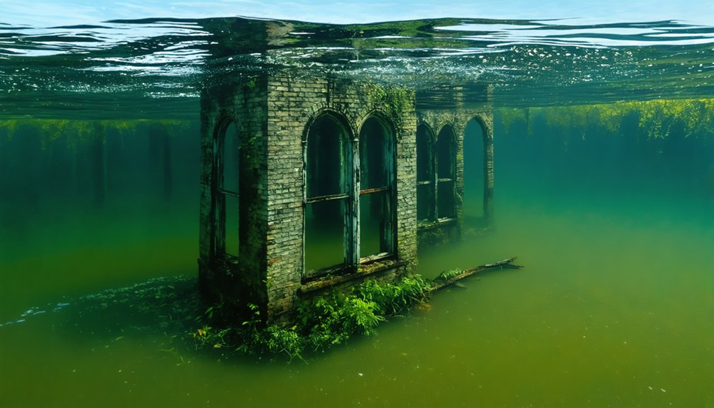
You’ll find the Great Crossings Bridge—a three-arch sandstone structure measuring 375 feet long and 40 feet high—constructed between 1813 and 1818 to carry the National Road across the Youghiogheny River.
This engineering achievement remains structurally intact despite residing 50 feet underwater since 1940, when the U.S. Army Corps of Engineers created Youghiogheny River Lake for flood control. The bridge’s dedication ceremony took place on July 4, 1818, with President James Monroe in attendance.
The bridge becomes visible only during severe droughts when water levels drop below 1,392 feet elevation, with recent exposures documented in fall 2024 (below 1,370 feet), 2019, 1998, and the 1950s-1960s. The U.S. Army Corps of Engineers has closed off the bridge to public access due to concerns about its structural stability and safety risks for visitors.
Historic Construction and Design
How does a sandstone bridge constructed over two centuries ago remain structurally intact beneath 50 feet of water? The Great Crossings Bridge demonstrates remarkable maritime engineering through its three-arch configuration, spanning 375 feet across the Youghiogheny River. Built between 1813 and 1818 by James Kinkead, James Beck, and Evan Evans, this 40-foot-high structure utilized locally-sourced sandstone blocks secured without modern adhesives.
The 30-foot-wide roadbed carried National Road traffic until the 1940’s submersion. You’ll observe preservation challenges as the U.S. Army Corps of Engineers doesn’t maintain the structure’s integrity.
During reservoir drawdowns, exposed stone piers reveal minimal erosion—testament to craftsmen’s precision. President Monroe’s 1818 dedication ceremony recognized engineering excellence that defied conventional bridge-building limitations, establishing standards for transportation infrastructure you’d recognize today. The reservoir’s seasonal water level changes can expose foundation remains of the original structures when lowered during winter months. The bridge originally connected to Somerfield, which now lies flooded beneath the lake, its original structures submerged alongside the historic crossing.
Rare Underwater Exposures
Since 1944, the Youghiogheny River Lake has concealed the Great Crossings Bridge beneath water levels averaging 50 feet deep at normal summer pool elevation of 1,439 feet above sea level.
You’ll witness the structure emerge only when water drops below 1,392 feet—a phenomenon occurring every 5-10 years during winter drawdowns. The November 2024 drought produced the fifth-lowest recorded level at 1,362.18 feet, exposing stonework unseen since 1998 and drawing over 10,000 visitors.
This six-week exposure revealed both the bridge’s foundation and Somerfield’s submerged ruins before precipitation submerged it again December 13.
The bridge was constructed from sandstone with three arches, measuring 375 feet long, 40 feet high, and 30 feet wide. Built in 1818, the structure historically served travelers along the National Road until the early 1940s, connecting Fayette and Somerset counties.
Historical preservation remains impossible underwater, while the ecological impact of periodic exposures on lake ecosystems requires ongoing monitoring by the U.S. Army Corps of Engineers.
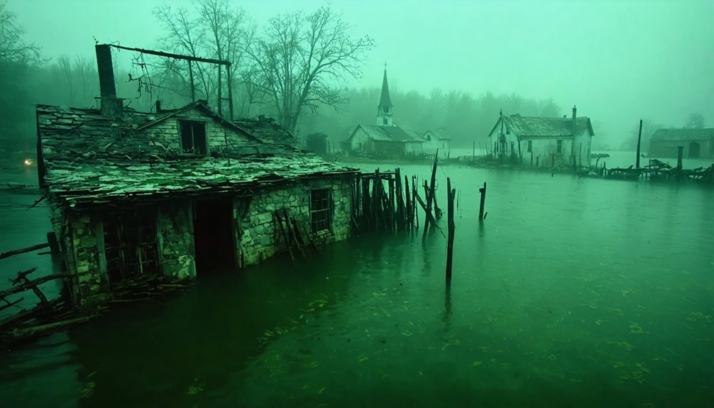
Livermore: From Johnstown Flood Victim to Dam Sacrifice
When John Livermore established his eponymous settlement in 1827 along the Conemaugh River, he positioned it strategically between Blairsville and Saltsburg in Derry Township, Westmoreland County.
The Pennsylvania Canal system sustained the town’s economy until the catastrophic Johnstown Flood of 1889 rendered the waterway inoperable, severing vital trade routes.
The 1936 St. Patrick’s Day Flood inundated Livermore with eighteen feet of water, destroying infrastructure and claiming one life.
Federal intervention followed: the Army Corps of Engineers mandated demolition in the early 1950s for dam construction.
Fifty-seven residents relocated as historical preservation yielded to flood control objectives.
The 1952 Conemaugh Dam submerged Livermore’s foundations, creating ecological impact through reservoir formation while preventing $2 billion in subsequent flood damage—quantifiable evidence of sacrificing community autonomy for regional protection. Despite its submersion, Livermore Cemetery remains above the water line, where visitors report paranormal phenomena including phantom footsteps and unexplained equipment malfunctions. Local folklore attributes the town’s destruction to a witch’s curse from the late 1790s, when a woman accused of witchcraft allegedly promised floodwaters would consume the area a century after her death.
The Witch’s Curse Legend of Livermore
Local folklore attributes Livermore’s destruction to supernatural causation originating over a century before the town’s 1827 establishment.
Legend claims a witch’s curse sealed Livermore’s fate long before the settlement’s founding, predicting its eventual watery demise.
You’ll find documented claims of a witch’s execution and her pronouncement that flood waters would submerge the area precisely one hundred years post-mortem on May 31st.
The 1889 Johnstown Flood fulfilled this timeline with documented precision, destroying historical ice houses and infrastructure.
Subsequent events—1936’s catastrophic inundation depositing 18 feet of water, eliminating commercial structures and claiming lives—reinforced belief in preternatural retribution.
The site’s intentional submersion beneath Conemaugh Reservoir in 1952 hasn’t eliminated paranormal reports.
Investigators document anomalous phenomena: unexplained audio recordings, temperature variations in the cemetery, and apparitions along former underground waterways.
The location retains its “Satan’s Seat” designation, meriting cautious exploration during daylight hours only.
Wilsonville: Drowned by Lake Wallenpaupack
The 12,000-acre tract James Wilson purchased in 1793 underwent systematic transformation when PPL Corporation acquired land from 100 owners at $20 per acre between 1924-1926.
Construction crews rerouted 17 miles of roads and utility infrastructure while relocating Purdytown Cemetery to accommodate the reservoir’s 6,000-acre footprint.
The dam’s closure in 1926 initiated a seven-month flooding process that submerged Wilsonville and permanently altered the Wallenpaupack Creek watershed.
Wilson’s Land Becomes Lake
You’ll find the company acquired commercial and residential properties at approximately $20 per acre, demolishing or relocating structures before the 1924-1926 flooding.
The environmental impact was substantial: contractors clear-cut forests, though sonar reveals remaining stumps beneath the surface.
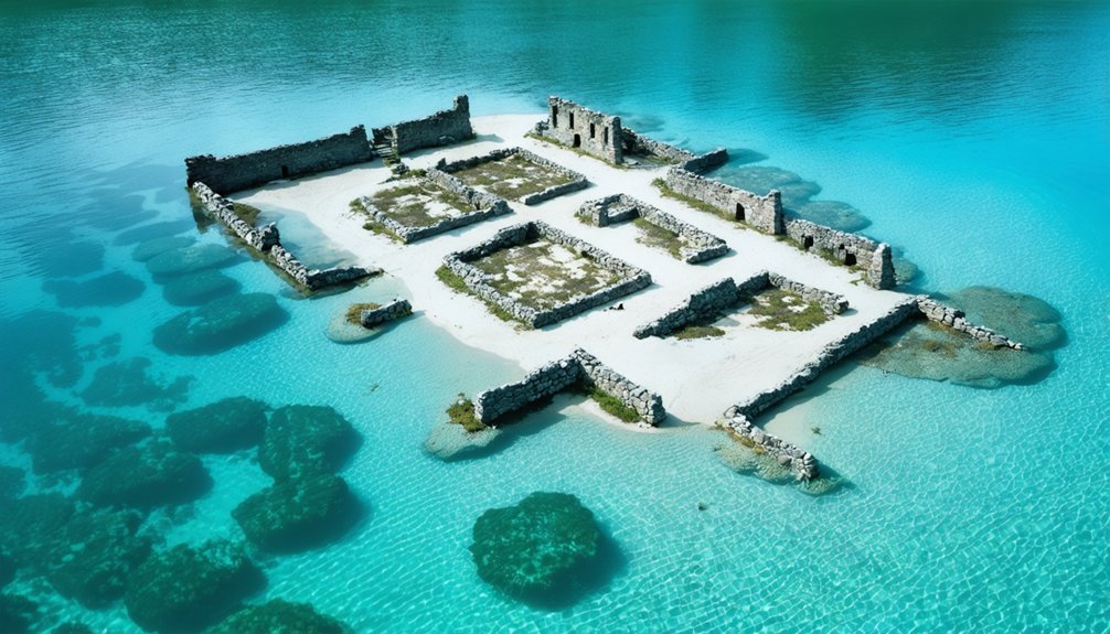
Wilson’s namesake settlement vanished entirely, leaving only submerged foundations and stone walls as archaeological evidence of the commonwealth’s drowned past.
Relocated Cemetery and Roads
Before inundating 5,700 acres, PP&L executed systematic infrastructure displacement across seventeen miles of affected terrain between 1924-1926.
You’ll find documented evidence of complete cemetery exhumation, with remains relocated to preserve burial sites from permanent submersion.
The cultural impact extended beyond graves—Welwood Avenue’s rerouting altered regional connectivity patterns fundamentally.
Three critical relocations occurred:
- Cemetery grounds: Complete exhumation coordinated with descendant families
- Road networks: Seventeen-mile realignment preserving access corridors
- Communication infrastructure: Telephone pole displacement matching transportation routes
Historical artifacts potentially remaining underwater include foundation stones, road remnants, and logging-operation tree stumps—observable via sonar imaging and during low-water events.
While myths suggest intact structures persist, archaeological evidence confirms systematic demolition preceded flooding.
You’re observing engineered transformation, not preservation.
The Great St. Patrick’s Day Flood of 1936
During winter 1935-36, meteorological conditions converged to create what’d become Pennsylvania’s most catastrophic flood event of the twentieth century.
You’ll find that 63 inches of snowpack, combined with frozen ground impermeability, eliminated natural absorption capacity. When March 16 brought two inches of rain and thermal melting, river ecology couldn’t accommodate the rapid discharge.
Waters reached 46 feet at Pittsburgh’s Point—21 feet above flood stage—inundating 65% of the business district. The deluge killed over 100 Pennsylvanians, displaced 135,000 residents, and caused $300 million in damage.
Fifty bridges collapsed, steel mills ceased operations, and 60,000 workers faced unemployment.
This disaster ultimately prompted federal flood insurance programs and exhaustive river management reforms you’d recognize today.
Dam Construction and the Flood Control Acts
The catastrophic losses from March 1936 galvanized Congress to pass the Flood Control Act on June 22, 1936, establishing the first federally-coordinated flood mitigation program in United States history.
You’ll find this Copeland Omnibus Act authorized nine reservoirs across Pennsylvania’s upper Allegheny Valley, addressing industrial vulnerabilities exposed when Pittsburgh’s business district submerged under 21 feet of water.
The Army Corps of Engineers confronted significant engineering challenges implementing this systematic approach:
- Kinzua Dam (1965): Required condemning 10,000 acres of Seneca Nation territory despite tribal opposition.
- Hammond-Tioga Project (1979): Cost exceeded $200 million controlling 402 square miles of drainage.
- Prompton Dam (1960): Utilized restricted-outflow conduits for downstream regulation.
Each structure generated substantial environmental impact, permanently submerging communities while delivering flood protection you’d previously lacked.
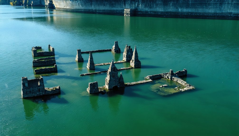
What Remains Visible Today: Ruins and Artifacts
When reservoir water levels recede during drought conditions or scheduled drawdowns, you’ll observe structural remnants that document pre-inundation settlement patterns.
Stone bridge arches emerge as the most architecturally intact features, exhibiting masonry techniques and load-bearing configurations from 19th-century construction methods.
Foundation walls, street grid layouts, and preserved organic materials—including standing timber and root systems—provide stratified evidence of town morphology and vegetation communities prior to controlled flooding.
Exposed Stone Bridge Arches
Beneath Youghiogheny River Lake’s surface, stone arches of the Great Crossings Bridge remain structurally intact despite submersion under 50 feet of water since 1940. During severe drought conditions in fall 2024, you’ll witness archaeological findings revealing this 206-year-old National Road infrastructure—a monument to pre-modern engineering that requires no modern restoration despite eight decades underwater.
The exposed structure demonstrates remarkable preservation:
- Core arch integrity: Multiple stone spans maintain load-bearing capacity, permitting pedestrian traversal during exposure events.
- Drought-dependent access: Historic low water levels (lowest in 25 years) create explorable conditions approximately twice since impoundment.
- Contextual ruins: Somerfield village foundations, sidewalks, and street remnants materialize alongside bridge remnants.
You’re observing engineered permanence—stone masonry outlasting the civilization it served, accessible only when climate conditions permit direct examination of subaqueous historical sites.
Foundations and Street Remnants
Beyond bridge infrastructure, cement foundations and residential structural elements persist as primary archaeological indicators across submerged Pennsylvania settlement sites.
You’ll find multi-story house footprints with preserved front steps beneath mud accumulation, while foundation archaeology reveals construction patterns through visible grooves indicating structural reinforcement methods.
Wall sections demonstrate varied preservation states, with lower portions maintaining structural integrity despite decades of submersion.
Fireplace remnants display original indentations and masonry techniques from late 1700s construction periods, documenting domestic heating infrastructure.
Stone configurations expose multiple-layer building practices where protective concrete coatings have crumbled away, leaving metamorphic rock fragments like schist visible.
Metal detector activity confirms continued artifact discovery within these ruins, with concentrated deposits marking excavation zones.
These foundation structures, spanning 1827 to 1940, provide tangible evidence of architectural progression across generations.
Submerged Trees and Stumps
Although contracted loggers systematically removed most vegetation before dam construction, submerged tree stumps and standing trunks remain as prominent biological markers across Pennsylvania’s flooded settlement sites.
You’ll find these remnants serve multiple investigative purposes:
- Tree ring analysis enables precise dating of settlement chronology and pre-flooding climate conditions.
- Underwater ecology studies reveal how preserved wood structures create habitat zones within reservoir ecosystems.
- Sonar mapping identifies standing white pines and conifers that loggers left behind during incomplete clearance operations.
When Lake Wallenpaupack’s levels drop, you can observe Somerfield’s stumps protruding through exposed mud along former street alignments.
These specimens retain structural integrity despite decades of submersion, their cellular composition preserved by anaerobic lake-bottom conditions.
Sonar equipment reveals tall standing trees beneath the surface, documenting the valley’s original forested landscape.
Exploring the Underwater Ghost Towns During Low Water
When hydrological conditions permit, the submerged townscapes of Somerfield and Livermore transform into accessible archaeological sites that reveal preserved remnants of mid-20th century displacement. You’ll navigate former Bridge Street and River Road when reservoir drawdowns exceed 100 feet, exposing foundations and infrastructure protected by aquatic ecosystems for decades.
The November 2024 drought created unprecedented access to the 1818 Great Crossings Bridge ruins—only the second visibility event since dam completion. You’re walking mid-street through sites where water quality typically maintains 100-foot depths.
Route 22 West provides entry to Livermore’s nature-reclaimed floodplains, while Somerfield’s 1860 street grid emerges intact. These regulated drawdowns by the U.S. Army Corps of Engineers offer unrestricted temporal windows for documenting submerged cultural resources.
Paranormal Activity and Urban Legends at Submerged Sites
Beneath Lake Wallenpaupack’s 5,700-acre expanse, Wilsonville’s submerged infrastructure has generated documented paranormal claims since the dam’s 1926 completion flooded commercial districts, residential zones, and Lenape burial grounds.
Haunted legends center on construction worker McDonald’s drowning—witnesses reported his body appeared forcibly submerged despite no proximate individuals. These submerged mysteries manifest through reported spectral phenomena at three critical zones:
- Lenape burial grounds: Unmarked graves disturbed during flooding generate acoustic anomalies witnesses describe as whispers.
- Commercial district remnants: Sonar-detected structures correlate with concentrated paranormal activity reports.
- Cemetery relocation sites: Incomplete exhumations left biological material beneath current waterline.
Investigation teams document electromagnetic field variations and temperature fluctuations above submerged Wilsonville coordinates. The reservoir’s displaced communities and construction fatalities fuel ongoing urban legends about souls trapped in watery strata.
Frequently Asked Questions
Can You Scuba Dive or Kayak Over the Submerged Ghost Towns?
You can’t legally scuba dive over Pennsylvania’s submerged ghost towns due to reservoir restrictions, limiting marine exploration. However, you’re free to kayak surface waters above sites like Wilsonville, though historical preservation efforts don’t permit underwater access to ruins.
Winter visits to Pennsylvania ghost towns provide a unique opportunity to explore their haunting beauty during the cold season. The layered history, combined with the eerie atmosphere, makes these abandoned sites captivating for photographers and history enthusiasts alike. As snow blankets the structures, visitors can imagine the stories that once filled these towns.
Were Residents Compensated Fairly When Their Towns Were Flooded for Dams?
Historical records don’t detail specific compensation amounts for Livermore or Somerfield relocations, leaving compensation controversies unresolved. You’ll find no documented lawsuits, though relocation challenges amid 1940s-50s displacement suggest residents had limited recourse against government flood-control projects.
Are There Other Underwater Ghost Towns in Pennsylvania Besides These Three?
You’ll find four underwater ghost towns documented, not three: Marburg, Milford Mills, Social Hall, and Tohickon Village. Historical impact includes displaced communities, while archaeological discoveries remain submerged, limiting your access to these reservoir-locked sites for independent exploration.
How Often Do Water Levels Drop Enough to See the Ruins?
Like clockwork, you’ll witness ruins during annual November drawdowns for historical preservation, though severe droughts—occurring roughly once per decade—dramatically amplify environmental impact, exposing complete structures. The U.S. Army Corps documents approximately twelve significant revelation events since the 1940s.
Can You Visit the Sites Where These Towns Once Stood Today?
You can’t access most submerged Pennsylvania towns due to restrictions protecting historical preservation. Somerfield offers rare archaeological exploration opportunities during low-water events, while Livermore’s cemetery remains closed. Lake depths prevent direct visitation of structural remnants year-round.
References
- https://www.onlyinyourstate.com/trip-ideas/usa/432649
- https://pittsburghghosts.com/livermore-pennsylvania-ghost-town/
- https://wallybites.com/wilsonville-wallenpaupacks-underwater-town/
- https://en.wikipedia.org/wiki/Livermore
- https://www.youtube.com/watch?v=qCzDNVmZO5s
- https://www.youtube.com/watch?v=_DK6Anx_t8I
- https://bridgehunterschronicles.wordpress.com/2024/12/03/mystery-bridge-nr-227-the-submerged-bridge-at-somerfield-pa/
- http://swpare.blogspot.com/2011/01/youghiogheny-dam-and-forgotten-town-of.html
- https://www.youtube.com/watch?v=ujCWM9PefHI
- https://www.somerset.pagenweb.org/addison/somerfield_town.htm


