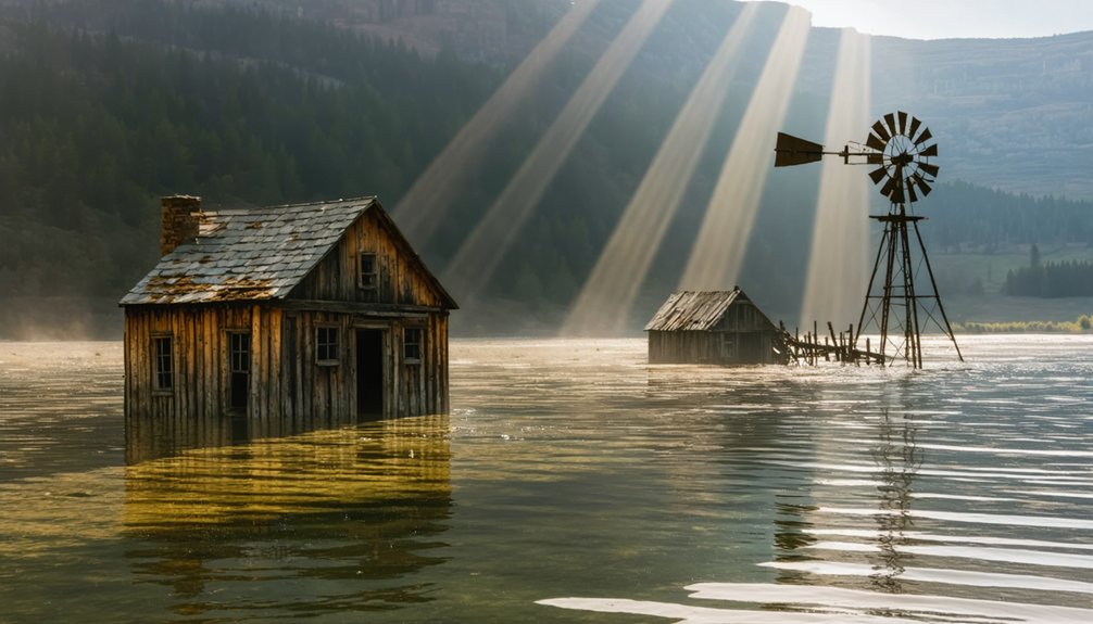
You’ll find at least three documented frontier settlements submerged beneath South Dakota’s reservoirs, with Camp Crook under Pactola Lake representing the most archaeologically significant site. Established in 1875 during the Black Hills gold rush, this mining community was inundated following the dam’s 1952–1956 construction under the Pick-Sloan Flood Control Act. Structural remnants—including foundations, cabins, and bunkers—remain preserved at depths reaching 140 feet, though sediment accumulation and poor visibility create challenging documentation conditions. These submerged archaeological sites offer unique insights into the region’s complex history of development versus preservation.
Key Takeaways
- Camp Crook, established in 1875 near Pactola Lake, was submerged in the 1950s during dam construction.
- Pactola Dam’s creation displaced over 300 residents and flooded historic mining settlements under the Pick-Sloan Flood Control Act.
- Structural remnants including foundations, bunkers, and cabins remain underwater at depths reaching 140 feet in Pactola Lake.
- Sheridan is another South Dakota community submerged beneath Sheridan Lake, with remains preserved underwater like Camp Crook.
- Poor water clarity and sediment buildup make these underwater ghost towns challenging to explore and document archaeologically.
The Rise and Fall of Camp Crook: From Gold Rush to Ghost Town
When General George Crook’s troops established a military encampment near present-day Pactola Lake in 1875, they inadvertently founded what would become one of the Black Hills’ most ephemeral mining settlements.
A military encampment birthed an unintended legacy—one of the Black Hills’ most fleeting settlements, destined for obscurity.
You’ll find Camp Crook emerged during the Panic of 1873‘s aftermath, when prospectors violated the 1868 Treaty of Fort Laramie seeking economic opportunity.
The settlement’s mining technology centered on placer operations, extracting gold from Rapid Creek’s alluvial deposits.
Settlement architecture remained rudimentary—typical of transient boom camps prioritizing extraction over permanence.
Despite developing faster than neighboring Buffalo, Camp Crook’s bypassed county seat status limited infrastructural investment.
The military presence reflected broader campaigns to control dissident Native bands following gold’s discovery in 1874, with Fort Sheridan and similar posts established to suppress Sioux resistance throughout the region.
Resource exhaustion proved inevitable as placer yields diminished, while hardrock mining operations concentrated elsewhere.
By the time Deadwood installed its colored street lights in July 1908, Camp Crook had already faded from regional prominence.
The town’s decline accelerated through the early 1900s, leaving minimal archaeological evidence before Pactola Lake’s waters submerged this freedom-seeking community‘s remnants.
Why Pactola Dam Swallowed an Entire Settlement
Although Pactola ranked as Pennington County’s oldest settlement since the 1870s, the community’s historical significance couldn’t prevent its deliberate inundation under federal water management policy.
The Pick-Sloan Flood Control Act of 1944 authorized the dam’s construction, prioritizing Rapid City’s water supply and flood mitigation over preservation of historical sites.
Government entities condemned all property below 4,621.5 feet elevation, effectively erasing your access to this cultural landscape.
Construction crews systematically dismantled the settlement between 1952-1956, salvaging buildings and infrastructure before flooding commenced. Nearly 200 workers participated in the project, earning wages between $1.25-$2.75 an hour while moving millions of cubic yards of earthfill and rockfill.
The settlement once housed over 300 residents who worked the placer mining operations and established one of the Black Hills’ first post offices.
Today, you’ll find water recreation opportunities where miners once extracted gold, though haunted stories persist about submerged structures beneath the reservoir’s surface.
The dynamite bunker and abandoned cabins remain entombed underwater, inaccessible archaeological resources sacrificed for municipal utility.
What Lies Beneath: Exploring the Submerged Remains
Beneath Pactola Lake’s recreational surface at depths reaching 140 feet, archaeologically significant structural remnants from the 1870s mining settlement persist in deteriorating condition. Maritime archaeology techniques would reveal the dynamite bunker’s concrete integrity and foundation stones marking former commercial districts.
However, you’ll find accessibility severely restricted—this submerged site ranks as the Black Hills’ most challenging ghost town to document. Underwater preservation faces constant degradation from recreational boat traffic, sediment accumulation, and thermal stratification cycles.
Local legends often exaggerate what’s visible, though diving expeditions could catalog remaining structural elements before complete disintegration occurs. The reservoir was constructed between 1952-1956 following the Pick-Sloan Flood Control Act of 1944, transforming the mining settlement into South Dakota’s most unusual historical preservation site. The single surviving cabin downstream offers tangible connection to pre-dam settlement patterns, while most relocated buildings now exist in Silver City, preserving architectural heritage above water where you’re free to explore without specialized equipment. The lake now serves as a popular recreational area for fishing, boating, swimming, and hiking activities throughout the year.
The Pick-Sloan Flood Control Act and South Dakota’s Drowned Communities
The Flood Control Act of 1944 authorized unprecedented hydraulic infrastructure development across the Missouri River Basin, institutionalizing a merged engineering vision that would permanently alter South Dakota’s landscape through reservoir inundation.
You’ll find that Pick-Sloan’s implementation constructed Oahe, Fort Randall, Big Bend, and Pactola dams between 1946-1966, submerging communities across multiple Dakota reservations.
The flood impact eliminated 353,313 acres from Yankton, Rosebud, and Santee territories alone.
Native displacement affected nearly 1,000 families as White Swan disappeared beneath Fort Randall’s waters and Fort Thompson vanished under rising Lake Oahe.
Engineers promised 1 million irrigated acres as compensation—promises that remained largely unfulfilled through 2016.
The U.S. Army Corps of Engineers and Bureau of Reclamation divided jurisdictional authority over dam construction and hydroelectric development following the October 1944 Omaha Conference.
Grave disturbances at Fort Randall exemplified the cultural devastation, with ancestral remains only recovered when drought exposed former riverbeds in 2000.
The inundation submerged burial sites that held spiritual significance to the Lakota and Sioux tribes, including those of early settlers like Abner Daly.
Diving Into History: How to Experience Camp Crook Today
While massive reservoir projects like Oahe displaced indigenous communities across central South Dakota, Pactola Dam‘s construction in the Black Hills erased Camp Crook—a settlement whose military and mining heritage now lies preserved in an unintended underwater archive.
Pactola Dam transformed Camp Crook from a living Black Hills settlement into an accidental underwater museum of frontier military and mining history.
Accessing Camp Crook’s submerged remains requires:
- Recreational diving certification – Navigate depths where rotting structures persist beneath Pactola Lake’s surface.
- Historical exploration permits – Coordinate with local authorities before documenting underwater archaeological features.
- Specialized equipment – Cold-water gear essential for examining the dynamite bunker and possible downstream cabin remnants.
You’ll find minimal above-water evidence of the 1875 cavalry outpost or subsequent mining operations.
The 4,319,993 cubic yards of embankment fill created conditions that both protect and obscure Camp Crook’s physical record, offering freedom-seekers a unique opportunity to witness preservation through submersion rather than traditional conservation methods. The lake’s water clarity rarely permits visibility of these submerged structures due to depth variations throughout the reservoir.
Like Sheridan beneath Sheridan Lake, Camp Crook represents one of several Black Hills communities sacrificed to modern water infrastructure development.
Frequently Asked Questions
Are There Other Ghost Towns Underwater in South Dakota Besides Camp Crook?
Yes, you’ll find several submerged settlements beyond Camp Crook. Pactola Lake covers Barren, Deerfield, and Pactola town sites, while Lake Oahe inundated Forest City and LeBeau. Sheridan Lake submerged Sheridan. These sites offer unique underwater exploration opportunities for historic preservation documentation.
Were Residents Compensated When Camp Crook Was Flooded for the Dam?
Yes, you’ll find residents received compensation when the government condemned their land under eminent domain for Pactola Reservoir construction. However, historical records don’t document specific compensation claims amounts or any resulting legal disputes from the 1950s displacement.
Can Artifacts Be Legally Removed From the Submerged Town Site?
No, you can’t legally remove artifacts. Legal restrictions classify submerged archaeological resources as state property requiring permits. Artifact ownership remains with South Dakota on state-controlled submerged lands, preserving cultural heritage while protecting your freedom through transparent regulatory frameworks.
What Happens to Camp Crook’s Remains During Drought Conditions or Low Water?
During drought conditions, you’ll observe Camp Crook’s submerged remnants becoming increasingly exposed as water level fluctuations lower the reservoir. Climate impact affects visibility of the dynamite bunker and foundation debris, creating accessible archaeological opportunities for preservation documentation.
Did Anyone Refuse to Leave Camp Crook Before the Flooding Occurred?
No documented evidence supports refusal claims—you’ll find these are urban legends rather than historical fact. Flood myths often emerge around reservoir projects, but government condemnation records show orderly relocation procedures preceded Pactola’s controlled inundation in 1956.
References
- https://973kkrc.com/south-dakota-underwater-ghost-town-2/
- https://www.youtube.com/watch?v=NIYpCOKhN88
- https://blackhillsvisitor.com/learn/pactola/
- https://www.onlyinyourstate.com/state-pride/south-dakota/underwater-ghost-town-sd
- https://www.onlyinyourstate.com/state-pride/south-dakota/pactola-underwater-ghost-town-sd
- https://kxrb.com/the-journey-to-south-dakotas-hidden-ghost-town/
- https://www.travelsouthdakota.com/trip-ideas/pactola-reservoir-south-dakotas-version-atlantis
- https://www.americanhistorycentral.com/entries/black-hills-gold-rush/
- https://www.cityofdeadwood.com/historic-preservation/page/timeline-deadwood-south-dakota
- https://www.youtube.com/watch?v=KXz6I5ZXleQ


