You’ll find at least seven complete towns submerged beneath Tennessee’s reservoir system, primarily resulting from TVA dam construction between 1933-1946. Notable sites include Loyston (90 feet under Norris Lake), Butler (150 feet beneath Watauga Lake with 20,000 exhumed graves), and Cherokee heritage sites like Tanasi and Chota under Tellico Lake. Lewis Hine’s 1933 photographs documented Loyston’s final days, while archaeological surveys have mapped foundations, roads, and structures visible during drawdowns. These displacement projects affected approximately 2,761 families and submerged cemeteries, churches, and cultural landmarks—physical evidence that reveals Tennessee’s complex infrastructure history.
Key Takeaways
- Tennessee Valley Authority dam projects submerged entire towns like Loyston, Butler, and Rhea Springs, displacing thousands of families for hydroelectric power and flood control.
- Loyston lies 90 feet underwater in Norris Lake, preserving streets, churches, and businesses documented in 1933 photographs by Lewis Hine before submersion.
- Butler was relocated after the 1940 flood killed six people; Watauga Dam submerged the town beneath 150 feet of water, requiring 20,000 grave exhumations.
- Cherokee sacred sites including Tanasi and Chota now rest underwater in Tellico and Nickajack lakes, severing cultural continuity and spiritual connections.
- Underwater foundations, roads, and artifacts become visible during lake drawdowns, offering archaeological insights into these lost communities and cultural heritage.
The Tennessee Valley Authority’s Legacy of Submerged Communities
When the Tennessee Valley Authority Act passed in 1933, it granted the federal government sweeping eminent domain powers that would fundamentally reshape the region’s landscape and displace thousands of residents.
You’ll find that approximately 2,000 families faced mandatory relocation during Chickamauga Dam’s construction alone, with entire communities like Bakewell, Soddy, and Harrison disappearing beneath reservoir waters. The economic impact devastated established settlements—hosiery mills, gristmills, stores, and schools vanished permanently.
While landowners received compensation and relocation assistance, many families refused to abandon generational farms despite soil depletion and rural poverty. The environmental changes proved irreversible: thousands of acres of farmland submerged for flood control and power production, erasing historical sites like Fort Henry’s Civil War remnants and fundamentally altering Tennessee’s river ecosystems. Norris Dam’s creation of Norris Lake in the 1930s flooded towns including Big Barren, where 25 deaths occurred during the devastating 1916 flood before the area was ultimately submerged.
The Watauga Dam project required relocating 125 homes and 50 businesses from Butler, with workers exhuming 1,281 graves—including some unmarked and Indian burial sites—before the original town site disappeared beneath Watauga Lake.
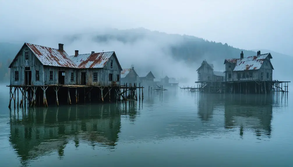
Loyston: Tennessee’s Best-Documented Underwater Settlement
Among the Tennessee Valley Authority’s displaced communities, Loyston stands out for its exceptional archival documentation. You’ll find this settlement, established around John Loy’s foundry in the early 1800s, now rests 90 feet beneath Norris Lake’s Loyston Sea.
Lewis Hine’s 1933 photographs captured the town’s final days—its Methodist Episcopal Church, filling station, and 70 residents before Norris Dam’s 1936 completion submerged everything.
Lewis Hine documented Loyston’s church, businesses, and seventy souls before Norris Dam’s waters erased their world forever.
TVA sociological surveys meticulously recorded displacement impacts, including residents’ choice to relocate independently rather than accept government-assigned fertile lands. While ancient artifacts from this community remain preserved underwater, new underground ecosystems have colonized the submerged structures.
The town once featured a post office, school, churches, and small businesses that served as the backbone of this early 19th century trading center. Before flooding, Loyston served as a trading hub for local farmers along State Highway 61.
This data-rich site represents your most thoroughly documented example of eminent domain’s human cost during Depression-era infrastructure development.
Rhea Springs and the Loss of a Grand Resort Destination
How does a thousand-acre resort destination vanish beneath 90 feet of engineered reservoir? You’ll find Rhea Springs‘ answer in the TVA’s 1936 river management plan.
This mineral spring healing site, rooted in Native American spirituality, drew patrons from Atlanta, Memphis, and New Orleans seeking hydrotherapy treatments since the 1790s. The resort’s mineral waters allegedly cured liver, stomach, and kidney ailments, establishing it as East Tennessee’s largest watering place.
The 1878 yellow fever epidemic amplified its fame as a refuge. By the 1930s, the settlement encompassed a lavish hotel, Methodist church, academy, and hundreds of residents. Visitors often stayed weeks at a time at the resort, enjoying the healing waters and social activities.
The TVA Act changed everything—800 families surrendered their land. Residents received a letter regarding their land needs on August 1, 1936. Watts Bar Dam’s completion in 1942 submerged the entire community. Today, only the cemetery remains accessible above the reservoir’s surface.
Butler: The Only Incorporated Town Beneath TVA Waters
Butler’s location at the confluence of Roan Creek and the Watauga River made it susceptible to catastrophic flooding events, including seven major floods between 1867 and 1940 that culminated in a violent 1940 event killing six people. The 1940 flood also destroyed the railroad line from Elizabethton to Mountain City, which was never rebuilt.
The Tennessee Valley Authority responded by constructing Watauga Dam in 1942, halting construction during World War II before resuming in 1946 and closing the gates on December 1, 1948. The dam’s massive structure required over 1.48 million cubic yards of clay and 2 million yards of rock to complete.
This engineering solution necessitated relocating 650-761 families through eminent domain acquisitions and exhuming over 20,000 graves, ultimately submerging Butler under 150 feet of water—the only incorporated municipality flooded by TVA operations.
Butler’s Devastating Flood History
When the Tennessee Valley Authority constructed Watauga Reservoir, Butler earned the somber distinction of becoming the only incorporated town permanently submerged beneath TVA waters.
You’ll find this submerged archaeology site distinguished from neighboring communities—unlike Big Sandy, which dykes protected, or unincorporated settlements that lacked Butler’s legal status.
The town’s century-long existence along the Watauga River ended when structures, roads, and graves disappeared beneath the reservoir’s surface, creating underwater ecosystems where streets once connected homes.
Today’s flood risk data reveals ongoing vulnerability: 32.5% of properties face flood threats annually, projected at 30.7% over thirty years.
FEMA floodzone X classification means you’re not required to carry flood insurance despite high risk scores, particularly concerning given the area’s $36,000 median household income—substantially below national averages.
While the area faces moderate earthquake risk at 41%, the primary hazard remains water-related threats from the reservoir and surrounding flood-prone terrain.
Geographic information systems provide visual mapping of current floodplain boundaries and inundation zones throughout the Butler area.
Watauga Dam Construction Response
The Tennessee Valley Authority initiated Watauga Dam construction in 1942, implementing a terrace-structured design engineered for dual-purpose flood control and hydroelectric power generation.
You’ll find archaeological evidence contradicting myth debunking claims that Butler’s submersion was unnecessary—documented floods in 1867, 1886, 1901, 1902, 1916, 1924, and 1940 killed six people and destroyed infrastructure.
Construction halted during World War II, resuming in 1946 despite resident skepticism. The Authority acquired nearly 12,000 acres through eminent domain, displacing 761 families at undervalued compensation rates.
Power generation commenced August 29, 1948, with gates closing December 1, 1948. Butler became the only incorporated town TVA flooded, submerging over 20,000 exhumed remains beneath 150 feet of water.
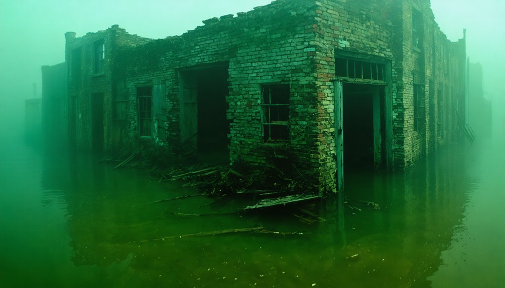
The 1983 drainage exposed foundations, roads, and structures—tangible archaeological evidence confirming the town’s physical erasure.
Town Relocation and Emergence
Among depression-era TVA projects, Butler represented the largest single community removal and remains the only incorporated town the Authority submerged across its southeastern modernization program.
You’ll find that 761 families relocated from nearly 12,000 acres before reservoir filling in 1948. The relocation infrastructure included 54.9 miles of roads, three bridges, and 66 miles of utility lines. Construction crews moved 1,281 graves to higher ground, though some families left ancestral sites undisturbed.
When 1983 dam servicing lowered water levels, Old Butler emerged as “the town that wouldn’t drown.” Exposed foundations, stone walls, and preserved building pads revealed how submersion altered river ecology and sedimentation patterns.
Former residents returned during this drawdown, their emotional homecoming documented by television crews examining the underwater preservation phenomenon.
Cherokee Heritage Sites Lost to Dam Construction
You’ll find that TVA reservoir construction submerged multiple Overhill Cherokee towns of considerable archaeological significance, including Tanasi (Tennessee’s namesake) beneath Tellico Reservoir. Several settlements are also now under Nickajack Lake following dam completion in 1967.
These inundations created a dual displacement pattern: Cherokee communities experienced twentieth-century flooding of sites already lost through eighteenth-century warfare and forced removal, while European-American settlers faced mid-1900s relocations.
The submerged archaeological record now includes platform mounds like Toqua (added to the National Register in 1978 before 1979 inundation), burial sites containing hundreds of individuals, and thousands of artifacts that connect Mississippian cultures to historic Cherokee occupation.
Historic Cherokee Townsites Submerged
When TVA constructed Tellico Dam during the 1970s, its impoundment obliterated approximately 16,500 acres of the Little Tennessee River valley, inundating archaeological sites that documented continuous human occupation spanning 10,000 years.
You’ll find Tanasi—the 1720s Overhill town from which Tennessee derives its name—now exists only as a reservoir-side marker five and a half miles southwest of Sequoyah Birthplace Museum. The original Chota townsite lies submerged beneath Tellico Reservoir, though Eastern Band of Cherokee maintains an elevated memorial with pillars representing seven clans.
Salvage excavations recovered ancient artifacts and 191 Native American remains before flooding, now housed at McClung Museum in Knoxville.
Sacred sites including Toqua community and Tellico Blockhouse settlements in Monroe County remain permanently inaccessible underwater, severing physical connections to ancestral heritage.
Dual Displacement: Cherokee and Settlers
Federal dam construction throughout Tennessee’s river valleys imposed sequential layers of dispossession—first targeting Cherokee sacred sites, then frontier settler communities established on those same ancestral lands.
You’ll find Tellico Dam submerged Tanasi and Chota townsites in the 1970s, destroying locations of spiritual significance where Cherokee connected with ancestors and the Great Spirit. Archaeological salvage excavated 191 remains and ancient artifacts now housed at McClung Museum.
Cherokee Dam’s 1940-1941 construction displaced Bean Station’s 87% of families, flooding historic taverns and Civil War battlegrounds.
Douglas Dam followed in 1942-1943, though Dandridge survived through petition.
Chickamauga Dam relocated 2,000 families, including Bakewell’s 40 African-American households. These federal projects systematically erased both indigenous ceremonial landscapes and subsequent settler communities without consent or adequate compensation.
Cultural Legacy Beneath Lakes
Beneath Tennessee’s reservoir systems lie inundated Cherokee ceremonial centers whose submersion represents quantifiable cultural erasure through mid-20th century federal hydroelectric development.
You’ll find Nickajack Dam’s 1967 completion flooded numerous Cherokee towns across southeast Tennessee, while Tellico Dam submerged the capitals Tanasi and Chota—operational 1721-1730—eliminating direct archaeological access.
The environmental impact extends beyond physical displacement: these sites remain underwater, creating permanent archaeological challenges for cultural documentation.
TVA’s wartime power priorities superseded preservation protocols, though pre-flooding salvage operations recovered artifacts now displayed at McClung Museum.
Cherokee Lake’s 28,780 acres and associated reservoirs transformed accessible heritage landscapes into inaccessible underwater zones.
Current memorial sites at Chota—elevated above flood levels and maintained by Eastern Band of Cherokee Indians—substitute for original townsite access, acknowledging what federal infrastructure permanently removed from public reach.
Fort Henry and Other Military Landmarks Now Underwater
Located approximately 12 miles west of Fort Donelson on the Cumberland River, Fort Henry occupied a strategically critical but fundamentally flawed position on the Tennessee River near Dover, Stewart County, Tennessee.
You’ll find this Confederate fortification represents a unique case of urban decay accelerated by environmental impact—the site’s poor engineering rendered it vulnerable to flooding that ultimately determined the battle’s outcome on February 6, 1862.
Heavy precipitation submerged the parade ground beneath two feet of water, compromising ammunition stores and positioning cannons below ideal firing angles.
Fort Henry’s strategic failure emerged when rising floodwaters rendered defensive positions inoperable before Union forces even arrived.
By February 8, floodwaters completely inundated the fortress.
This unconditional surrender opened Tennessee River navigation to Union forces, enabling systematic destruction of Confederate infrastructure upstream.
Today, the fort’s submerged remains demonstrate how hydrological factors can permanently alter military geography and strategic landscapes.
Fontana Lake’s Flooded Towns: Judson and Proctor

When the Tennessee Valley Authority initiated construction of Fontana Dam in 1942, the hydrological consequences permanently erased two thriving mountain settlements from Tennessee’s geographical record. Proctor and Judson, autonomous communities exceeding 2,000 residents collectively, vanished beneath 440 feet of engineered reservoir.
The 480-foot concrete structure displaced over 1,300 families who’d established submerged urban planning featuring schools, theaters, sawmills, and commercial infrastructure. You’ll find ancient artifacts occasionally surface during operational drawdowns, exposing road networks and cemetery foundations.
The government’s 1943 access agreement remains substantially unfulfilled—your right to reach ancestral burial grounds depends on boat navigation or arduous cross-country routes. This forced relocation eliminated 25% of Swain County’s population, demonstrating how centralized power projects prioritize industrial objectives over individual property rights and cultural preservation.
Frequently Asked Questions
Can Scuba Divers Explore the Underwater Ghost Towns in Tennessee?
You can explore several submerged Tennessee towns through scuba diving, particularly in Norris and Fontana Lakes’ clear waters. These historical wrecks aren’t designated tourist attractions, but they’re accessible during appropriate water conditions with proper diving certification and equipment.
Are Artifacts From Submerged Towns Preserved in Museums?
You’ll find Butler’s preserved artifacts in museums—including ancient relics like the horse-drawn hearse and mill equipment. However, maritime archaeology recovery from other submerged Tennessee towns remains limited, with most documentation focusing on grave relocations rather than artifact preservation.
How Were Residents Compensated When Their Towns Were Flooded?
How’d displaced residents fare financially? You’d receive government assistance through TVA’s compensation policies, which mandated fair market value payments for seized properties. However, documented evidence shows these standardized assessments often inadequately reflected actual relocation costs and emotional displacement.
Do Droughts Ever Expose the Submerged Towns to Visitors?
Yes, you’ll find droughts and winter drawdowns expose submerged settlements, creating dry lakebeds for exploration. You can access archaeological discoveries including foundations, cemeteries, and roads at Norris Lake’s Bean Station and Loyston during documented low-water events.
Were Any Historical Buildings Relocated Before the Towns Were Flooded?
You’ll find Butler’s “resettlement initiative” successfully preserved 125 homes and 50 businesses through systematic town relocation. However, preservation challenges plagued other communities—Loyston’s attempted move failed entirely, while Jefferson’s demolition proved unnecessarily destructive when floodwaters never materialized.
References
- https://www.tnmagazine.org/tennessees-underwater-ghost-towns/
- https://www.blueridgeoutdoors.com/go-outside/sunken-secrets-the-underwater-ghost-towns-of-the-blue-ridge/
- https://www.thesmokies.com/underwater-ghost-towns/
- https://www.thewanderingappalachian.com/post/the-underwater-towns-of-appalachia
- https://www.youtube.com/watch?v=1Db_kVj9qOc
- https://en.wikipedia.org/wiki/Loyston
- https://www.youtube.com/watch?v=wM7jS4r4SDE
- https://www.archives.gov/education/lessons/tva-relocation.html
- https://www.luc.edu/eminent-domain/siteessays/norristn/losttownloyston/
- https://7feetnorth.com/2018/04/16/the-underwater-ghost-town/