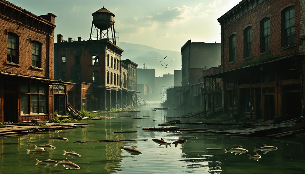
You’ll discover the Great Plains’ ghost towns aren’t scattered across prairies—they’re submerged beneath reservoirs. Preston, Texas, once a essential Butterfield Overland Mail crossing, disappeared under Lake Texoma in 1944. Hagerman’s agricultural hub, thriving after 1909’s railroad arrival, met the same fate. Oklahoma’s Uncas farming community vanished beneath Kaw Lake, while North Fork Town—site of the 1842 Creek Grand Council—lies under Lake Eufaula since 1964. Dam construction for flood control and hydropower displaced hundreds of families, leaving foundations, artifacts, and cemeteries visible only during extreme droughts. These sites reveal infrastructure’s human cost.
Key Takeaways
- Preston, Texas served as a Butterfield Overland Mail crossing before submersion beneath Lake Texoma in 1944, covering 89,000 archaeological acres.
- North Fork Town was submerged in 1964 after dam construction, containing artifacts from Indigenous presence and historic treaty signings.
- Uncas, Oklahoma lies beneath 110 feet of water, revealing building foundations, farm implements, and streets during drought conditions.
- Toledo Bend Reservoir construction in 1964 displaced communities and submerged 26 cemeteries containing 1,572 graves across the region.
- These towns were flooded by federal dam projects prioritizing hydropower and flood control, displacing residents through eminent domain.
Etowah: The Town That Vanished Beneath Lake Allatoona
When Mark Anthony Cooper surveyed the confluence of Stamp, McKaskey, and Allatoona Creeks in 1845, he recognized the hydropower potential that would transform this Etowah River location into Georgia’s most ambitious antebellum industrial complex.
Cooper’s Etowah Manufacturing and Mining Company produced twelve to fifteen tons of iron daily, supporting railroad expansion through spike and rail machinery production. The historical architecture encompassed blast furnaces, foundries, mills, and housing for 1,200 residents—a self-sufficient industrial town connected to Western & Atlantic Railroad’s river transportation network by 1859. Before the Civil War, the town’s population reached around 2,000 and included mills, a hotel, and workers’ homes.
A self-sufficient industrial town of 1,200 souls, producing fifteen tons of iron daily for America’s expanding railroads.
Union forces destroyed the complex in May 1864. The Battle of Allatoona Pass occurred months later on October 5, 1864, when Confederate General Hood’s campaign to destroy railroad lines resulted in a Confederate defeat. The U.S. Army Corps of Engineers’ Allatoona Dam construction submerged Etowah’s ruins between 1941-1949.
Cooper’s Furnace monument stands alone above the waterline, marking where Georgia’s industrial ambitions now rest beneath Lake Allatoona.
Coosawattee Valley: Cherokee Heritage Lost to Carters Lake
Where the Coosawattee and Conasauga rivers converge, the Cherokee established Ustanali as their nation’s capital—a settlement whose archaeological significance extends far beyond its eighteenth-century political prominence. You’ll find Cherokee history layered atop Mississippian foundations at the Little Egypt site (9 MU 102), where three platform mounds dominated 12.5 acres.
Archaeological remains reveal stratigraphic sequences from early-middle Archaic through Historic Cherokee occupation, with the main mound’s four construction stages documenting successive chiefdom developments around 1475 A.D. The valley’s location between the Cumberland Plateau and Smoky Mountains created natural corridors that concentrated prehistoric settlements along migratory paths used by indigenous peoples for millennia. The site’s platform mounds reflect the Southeastern Ceremonial Complex traditions that flourished during the Mississippian Era, with burial and platform structures indicating social hierarchy and religious practices. The U.S. Army Corps of Engineers’ Carters Dam flooded this irreplaceable cultural landscape in the early 1970s, creating Georgia’s deepest reservoir.
Pre-impoundment excavations uncovered Dallas and Hiawassee ceramic influences, pre-ceramic components, and evidence of paramount chiefdom governance—all now submerged beneath 376 square miles of watershed drainage.
Judson: A North Carolina Community Drowned for Progress
Six hundred mountain residents lost their homes when Fontana Dam’s reservoir submerged Judson in 1944—a calculated wartime sacrifice that transformed a self-sufficient Swain County settlement into North Carolina’s most contested submerged landscape.
You’ll find hidden histories beneath Fontana Lake’s surface: foundations, cemeteries, and infrastructure from a thriving Appalachian community that operated schools, sawmills, and churches. The Tennessee Valley Authority prioritized Manhattan Project electricity over community resilience, displacing over 1,300 families and submerging thirty-five burial grounds.
The government’s promised 30-mile replacement road—meant to restore cemetery access—became the notorious “Road to Nowhere” after completing just six miles. Swain County didn’t receive compensation until 2018’s $52 million settlement, seventy-four years after displacement. The dam’s construction provided hydroelectric power essential for WWII munitions and ship production facilities.
During extreme drawdowns, you can witness submerged remnants challenging official narratives about necessary wartime progress. The submerged town’s remains become visible approximately 1 to 3 times annually when lake levels drop significantly, offering rare glimpses of foundations and graves that once defined this mountain community.
Preston: Where the Butterfield Stage Once Crossed the Red River
You’ll find Preston’s historical significance rooted in its role as the official Red River crossing for the Butterfield Overland Mail, where Benjamin Franklin Colbert’s ferry transported the transcontinental stage line across the shifty waters from September 1858 until March 1861.
The Grayson County settlement marked the Division 6-7 boundary of the 2,795-mile route from St. Louis to San Francisco, with infrastructure investments including stage stations every twenty miles for employee housing, dining facilities, and livestock corrals.
John Butterfield, who had previously founded the American Express Company through alliances with Wells and Fargo, received the mail route contract from the postmaster general in 1857.
The transcontinental trip took approximately 21 to 23 days and cost passengers about $200.
Lake Texoma’s impoundment in 1944 submerged this once-vital crossing point, leaving behind archaeological deposits beneath approximately 89,000 acres of reservoir waters.
Historic Crossroads and Trails
Before Preston vanished beneath the waters of Lake Texoma in 1944, it stood as one of North Texas’s most strategically significant transportation hubs—the precise point where the Butterfield Overland Stage Line crossed the Red River into Texas.
Benjamin Franklin Colbert’s ferry facilitated this crossing, launching travelers onto 740 miles of Texas terrain toward El Paso.
Digital mapping now reveals Preston’s submerged infrastructure, where stations once stood every twenty miles with corrals, dining facilities, and livestock operations. Passengers traveling the route were advised to carry extra food and blankets, as only two meals were served daily at designated station stops. The route passed through significant Texas towns including Sherman, Gainesville, and Jacksboro, where travelers encountered the expansive plains characteristic of the region.
Archaeological excavations have documented the competing investments between Preston and Sherman, where Grayson County businessmen constructed new roads to redirect the profitable route.
You’ll find this crossing represented the gateway where semi-weekly mail service, beginning September 16, 1858, connected eastern and western termini across 2,795 miles of American frontier.
Life Before Lake Texoma
When Grayson County businessmen constructed their road to Preston in 1858, they transformed a tiny Red River community into the gateway for 2,795 miles of continental mail service.
You’ll find Preston’s selection wasn’t random—Captain R.B. Marcy’s 1849 expedition had documented this southern route’s superior terrain and minimal snow.
The Butterfield Stage entered Texas at Colbert’s Ferry, where flatboats ferried passengers and cargo across the Red River’s unpredictable channels.
Preston’s dominance lasted until Sherman paid Colbert’s Ferry passage fees, diverting the route southward.
What remain are forgotten legends of twelve Choctaw Nation stations and mystery legends surrounding the 192-mile Indian Territory section.
Stations appeared every 10-20 miles, requiring enormous capital investment in corrals, supplies, and infrastructure.
This 1858-1861 operation encouraged settlement before Civil War‘s intervention ended transcontinental service.
Remnants Beneath the Waters
The Preston crossing site sits beneath Lake Texoma’s waters today, its precise location marked by bathymetric surveys at approximately 96°04’W longitude where Colbert’s Ferry once operated.
You’ll find the submerged remnants of Preston’s riverbank infrastructure—flatboat ramps, stone foundations, and stage station footings—preserved in lake sediment layers.
Ancient artifacts from the Butterfield Stage era intermingle with Choctaw trade goods along the former Texas Road corridor.
Modern fisheries now occupy the 192-mile route that once took coaches 38 hours through Indian Territory.
Divers occasionally document rusted hardware and wagon wheel fragments embedded in the lakebed.
The reservoir’s stable environment has protected structural evidence that Sherman’s competing infrastructure couldn’t erase—Preston’s stone-lined ferry approaches remain archaeologically intact beneath fifty feet of impounded water.
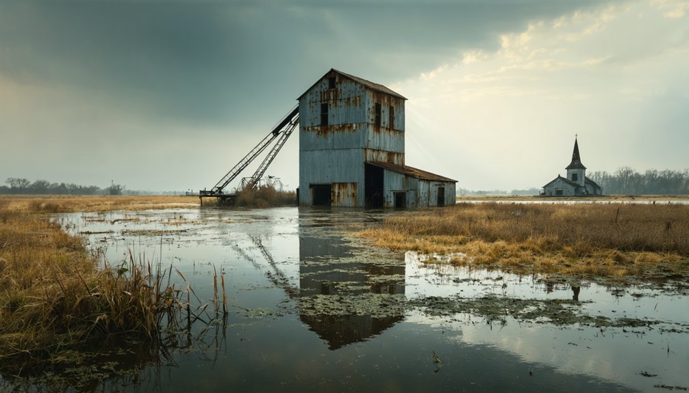
Hagerman: A Thriving Town Sacrificed to Lake Texoma
You’ll find Hagerman reached its demographic zenith in the 1930s-1940s with 150 residents, a population sustained by the Missouri-Kansas-Texas Railroad’s 1909 arrival at Dever Switch.
The community’s economy centered on agricultural commerce and rail transportation, with citizens relocating from the original Steedman settlement eight miles northwest of Sherman to capitalize on railroad access.
Before Lake Texoma’s 1944 impoundment forced abandonment in 1942, residents maintained standard rural operations including a church, cemetery, and farm-based enterprises along the spur off FM 1417.
Peak Population and Economy
As oil derricks punctured the Oklahoma landscape during the 1920s boom era, Hagerman’s population swelled to several thousand residents—a dramatic transformation from its agricultural origins. You’ll find the town’s economic diversification extended beyond petroleum extraction to include ranching operations and railroad-facilitated commodity transport along the Red River corridor.
During the 1951-1957 drilling intensification, private mineral rights generated substantial subsurface revenues while creating high-wage employment opportunities that drew workers statewide. This mirrored Oklahoma’s broader economic expansion, where gainful employment surged from 266,000 to 828,000 by 1930.
However, population decline accelerated when Denison Dam construction commenced in the 1930s, culminating in complete evacuation before Lake Texoma‘s impoundment submerged the community’s surface infrastructure while preserving underlying mineral estates under federal acquisition terms.
Life Before the Flood
Before economic prosperity gave way to forced evacuation, Hagerman’s residents built a functioning agricultural and transportation hub on Red River bottomland.
You’d have found 150 citizens maintaining farms, operating businesses along the MKT Railroad spur, and utilizing stage coach connections to Sherman by the 1930s.
The town’s strategic position on emigrant trails and fertile bottomland sustained generations until federal planners designated it for reservoir development.
When Denison Dam construction began in 1938, you witnessed systematic dismantling of infrastructure—railroads rerouted, highways relocated, cemeteries exhumed.
The 1946 establishment of Hagerman National Wildlife Refuge addressed impact on local wildlife displaced by flooding.
Today, cultural memory preservation exists through refuge exhibits and exposed grave markers during drought conditions, remnants of a community you’ll never walk through again.
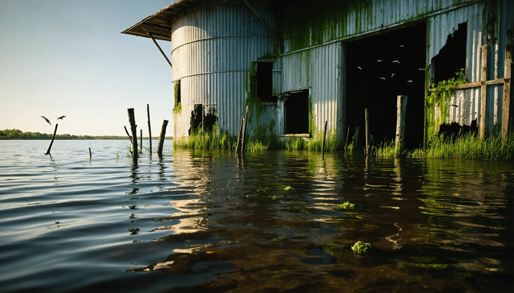
Cedar Mills: From Boom Town to Underwater Ruins
Norwegian immigrants founded Cedar Mills in the 1890s along Minnesota’s Cedar River, transforming the remote prairie site into a thriving milling operation that processed wheat into 200 barrels of flour daily at peak capacity.
Railroad access in 1899 catalyzed explosive growth—you’d have found 800 residents, three general stores, and harvest festivals drawing over 1,000 visitors by 1910.
The U.S. Army Corps of Engineers selected the site in 1939 for flood prevention infrastructure under the Flood Control Act.
Construction displaced fifty families before the $2.5-million dam flooded 5,000 acres in 1942.
Lake Carlos now submerges the town at forty-foot depths, where low-oxygen sediment enables archaeological preservation.
You’ll find sonar-mapped ruins spanning two miles, including the mill wheel and 1920s vehicles, attracting 500+ divers annually.
Toledo Bend’s Forgotten Cemeteries and Displaced Communities
When the Sabine River Authority initiated construction of Toledo Bend Reservoir in 1964, the Texas Archeological Salvage Project mobilized to document and relocate burial grounds across the projected 186,000-acre impoundment zone spanning the Texas-Louisiana border.
Burial preservation efforts addressed twenty-six cemeteries containing 1,572 graves. Archaeological challenges emerged immediately—thirty-nine of seventy-two graves at Toledo Bend Cemetery remained unidentified, while approximately ten family burial grounds on abandoned farms couldn’t be relocated because property owners disappeared.
Thirty-nine graves at Toledo Bend Cemetery defied identification, while ten family burial grounds vanished with their property owners.
Workers excavated six feet deep, using soil analysis to identify grave outlines where disturbed earth retained distinct boundaries.
Eight graves containing African American remains outside cemetery fences were relocated to Scott Cemetery.
Despite systematic documentation, multiple burial sites remain submerged beneath 110 feet of water, occasionally exposed during severe droughts like those in 2006 and 2011.
Uncas: An Oklahoma Farming Settlement Submerged by Kaw Lake
While Toledo Bend’s burial relocation efforts addressed twenty-six cemeteries across 186,000 acres, similar reservoir projects across the American South created additional drowned landscapes. You’ll find Uncas submerged beneath Oklahoma’s Kaw Lake, where the Army Corps of Engineers closed dam gates in 1976, permanently flooding this 1886 farming settlement.
The agricultural history of this Arkansas River valley community ends at a couple hundred residents—never experiencing the oil booms that transformed neighboring Kaw City.
Water level fluctuations now reveal what bureaucratic planning concealed: building foundations, farm implements, and street grids visible on the lakebed floor. Park roads incorporate original town streets, while former residents gather at reunions, maintaining collective memory of their evacuated community.
Lead park ranger Jim Anderson documents these submerged remnants for visitors seeking evidence of government-mandated displacement.
North Fork Town: The Crossroads Community Below Lake Eufaula
Beneath Lake Eufaula’s 102,500-acre expanse lies North Fork Town, a Creek settlement that functioned as the political and commercial nucleus of Indian Territory from its founding shortly after 1836.
You’ll find its coordinates at 35.290390, -95.582318, where the Texas and California Roads intersected half a mile east of modern Eufaula. This crossroads hosted the pivotal 1842 Grand Council and witnessed the 1861 Confederate treaty signing with multiple tribes.
The site’s cultural heritage extends millennia before Creek occupation, though archaeological findings remain submerged since the Canadian River dam’s 1964 completion.
The federal government acquired this territory through eminent domain, compensating individual landowners while bypassing the Muscogee (Creek) Nation entirely.
Your access to this historical record now requires diving equipment.
Frequently Asked Questions
Can You Scuba Dive to Explore These Submerged Ghost Towns?
No, you can’t scuba dive these sites. There’s no permitted underwater navigation, and removing ancient artifacts is illegal. Drought exposure—not diving—reveals stratigraphic layers when reservoirs drop 26+ feet, allowing legitimate archaeological excavation instead of recreational exploration.
Were Residents Compensated When Their Towns Were Flooded for Dam Projects?
Yes, you’d have received compensation through eminent domain land acquisition policies. Congress authorized funding for property buyouts, though compensation policies varied by project. However, some promises—like adequate relocation roads—weren’t always fulfilled, limiting your freedom to maintain community connections.
What Happens to Underwater Structures After Decades of Submersion?
You’ll find 90% of structures decay through hydrostatic pressure and corrosion, yet anaerobic conditions enable exceptional timber preservation in lake-bottom sediments. This archaeological significance attracts independent researchers documenting stratified ruins that government restrictions often prevent you from accessing freely.
Are There Maps Showing Exact Locations of Submerged Buildings?
No extensive maps exist. You’ll find historical cartography limited to pre-flood surveys and archaeological mapping conducted during drought exposures. Most precise locations remain undocumented, requiring you to navigate using historical records and topographic references independently.
Do Underwater Towns Attract Fish and Create Artificial Reef Habitats?
Yes, submerged structures function as artificial reef development in freshwater ecosystems, providing hard surfaces for algae, invertebrates, and cover for fish populations. You’ll find enhanced biodiversity around foundations, walls, and debris that mimic natural habitat complexity.
References
- https://yesterdaysamerica.com/history-submerged-georgias-drowned-towns/
- https://www.blueridgeoutdoors.com/go-outside/sunken-secrets-the-underwater-ghost-towns-of-the-blue-ridge/
- https://cedarbayoumarina.com/four-ghost-towns-under-lake-texoma/
- https://texashighways.com/culture/history/the-lost-underwater-towns-of-texas/
- https://z94.com/lost-oklahoma-towns-underwater/
- https://en.wikipedia.org/wiki/List_of_flooded_towns_in_the_United_States
- https://evhsonline.org/bartow-history/places/allatoona
- https://lisamrussell.substack.com/p/how-lake-allatoona-saved-broad-street
- https://evhsonline.org/bartow-history/places/etowah
- https://thecamakstone.wordpress.com/2013/10/11/the-lost-city-of-etowah-georgia/


