You’ll find northeastern reservoirs concealing entire communities beneath their surfaces, most notably Maine’s Flagstaff Lake, which submerged three townships—Flagstaff, Dead River Plantation, and Bigelow—when Long Falls Dam flooded over 20,000 acres in 1950. During droughts and drawdowns, foundations, street grids, and structures dating to the 1800s emerge from the water, revealing what eminent domain erased. Similar sites exist at New York’s Neversink Reservoir and throughout Appalachia, where stone bridges, mill remnants, and property boundaries remain preserved underwater, offering tangible evidence of displaced communities and their stories.
Key Takeaways
- Flagstaff Lake in Maine submerged three townships in 1950, with foundations and street grids visible during low water levels.
- Long Falls Dam flooded communities like Flagstaff and Dead River Plantation, displacing residents through eminent domain starting in 1947.
- Droughts and reservoir drawdowns expose stone bridges, foundations, and 200-year-old structures from submerged 1800s settlements.
- New York reservoirs including Neversink displaced 340 residents in 1942, submerging family farms and entire communities for water supply.
- Scuba diving and boat exploration provide visual access to underwater ruins, including mills, roadways, and structural remnants.
Flagstaff Lake: Maine’s Drowned Valley
When Central Maine Power completed Long Falls Dam in 1950, it submerged three entire townships beneath what became Maine’s largest man-made reservoir.
You’ll find Flagstaff Lake spanning over 20,000 acres north of Rangeley, where Flagstaff Village, Dead River Plantation, and Bigelow once thrived.
The Dead River valley’s flooded ecosystems now cover settlements dating to the 1800s, including mills, homes, and streets that supported logging communities.
Central Maine Power purchased land in 1930, cleared the flowage area by 1949, and forced residents’ evacuation.
Property owners received compensation through eminent domain, though some residents were reluctant to abandon their longtime communities.
Displaced families relocated to nearby towns like Eustis and Stratton, leaving behind homes that would soon rest beneath the rising waters.
Today, you can explore submerged wildlife habitats and town remnants when water levels drop, exposing foundations and street outlines.
Among these hidden gems are the underwater ghost towns in the Midwest, where history lies beneath the surface waiting to be uncovered. As you venture into these submerged landscapes, you might stumble upon old structures that give a glimpse into the lives once lived in these forgotten communities. Each visit offers a unique opportunity to witness the interplay between nature and history, as the water continues to reclaim what was once a bustling town.
In addition to those in the Midwest, there are also fascinating underwater ghost towns in Texas that tell stories of past lives and lost communities. When the lakes recede, remnants of these towns emerge, providing a striking contrast between the serenity of the water and the echoes of history. Adventurers seeking a deeper understanding of the state’s rich heritage will find that these submerged sites are both intriguing and haunting.
Scuba diving reveals structures left standing as waters rose, preserving evidence of communities destroyed for hydroelectric development.
The Dam That Changed Everything
The Long Falls Dam project on the Dead River transformed Maine’s landscape when construction began in 1947, creating Flagstaff Lake and permanently submerging four established communities.
You’ll find the towns of Flagstaff, Dead River Plantation, Bigelow, and portions of Carrying Place beneath approximately 20,000 acres of water.
Engineers and planners documented over 60 buildings, including homes, mills, and farms, before flooding commenced in 1950—preserving a record of what now exists only as underwater foundations and remnants.
The displacement forced families to relocate their homes and move cemetery graves to higher ground, a common practice among communities facing submersion by reservoir projects. Similar to West Virginia’s submerged town of Gad beneath Summersville Lake, these communities become visible again only during periodic lake drainages for dam maintenance.
Long Falls Dam Construction
After Central Maine Power Company secured land purchases beginning in 1930, the transformation of the Dead River valley into Maine’s largest man-made reservoir commenced through a two-decade construction effort.
Hydroelectric development accelerated when clearing crews arrived in 1948-1949 to remove vegetation from the designated flowage area. You’ll find that land acquisition methods proved controversial—eminent domain forced residents from their ancestral homes against their will.
The Dead River’s diversion occurred in fall 1949, preceding full impoundment. Long Falls Dam‘s completion in 1950 came at a cost of $4,800,000, with contractors Hollingsworth and Whitney Company executing Walter Wyman’s vision. By contrast, the earlier St. John Lumber Company dam began construction in 1907 with a comparatively modest $50,000 budget, though it too transformed its region’s logging economy.
The facility now controls Kennebec River flow while generating power and managing floods. Some structures like the schoolhouse were razed before flooding, while others remained standing due to compensation disputes with property owners. During low water conditions, you can still witness submerged remnants—silent testimony to communities sacrificed for centralized energy production.
Communities Lost to Flooding
Across America’s Northeast and Appalachia, hydroelectric and water supply projects erased entire communities from the map through deliberate inundation. You’ll find that New York’s reservoir system submerged small farm towns by 1913, prioritizing city water demands over rural settlements.
The Gilboa Dam’s 1917 completion and Pepacton Reservoir’s 1955 filling displaced 974 residents from communities like Neversink. Lake Texoma’s 1944 creation merged multiple settlements including Preston, Texas, which lost its identity as a once-prosperous crossing point on the Red River.
Historical preservation efforts documented these losses through TVA sociological surveys and Lewis Hine’s photographs of Loyston, Tennessee, before Norris Dam flooded it in 1935. Environmental impacts extended beyond human displacement—entire railroad sections vanished underwater, altering regional infrastructure permanently. Fontana Dam’s 1944 completion supplied crucial electricity to Oak Ridge during World War II military operations.
Communities Sacrificed for Progress:
- Andersonville, South Carolina: Submerged beneath Lake Hartwell despite 154-year history
- Loyston’s documented disappearance: Complete sociological record captured pre-flooding
- Cemetery access obstructed: Families require ferry transportation post-inundation
- Infrastructure losses: Delaware and Northern Railroad sections permanently submerged
- Drought exposures: Lake Texoma’s 2011 drop revealed Cedar Mills gravestones
Communities Lost Beneath the Waters
When you examine Flagstaff Lake’s 20,000-acre expanse near Eustis, Maine, you’re looking at three complete townships—Flagstaff, Bigelow, and Dead River—that disappeared beneath the reservoir following Long Falls Dam’s 1950 completion.
The hydroelectric project displaced entire communities through eminent domain proceedings, submerging homes, businesses, and infrastructure under rising waters that permanently altered the region’s settlement patterns.
During low water periods, you’ll find exposed foundations and street layouts that document the systematic flooding of this populated valley, offering measurable evidence of these relocated communities. Similar to Summersville Lake’s winter drawdowns, these seasonal water level changes reveal the hidden architecture of submerged settlements. The three stone arches of historic bridges demonstrate engineering craftsmanship that has endured over two centuries beneath the water’s surface.
Flagstaff Lake’s Submerged Villages
Beneath Flagstaff Lake’s 20 square miles of water lie the complete remains of two villages—Flagstaff and Dead River Plantation—that Central Maine Power Company systematically dismantled in 1949.
You’ll find these communities were erased when Long Falls Dam flooded the historic valley in 1950, creating a hydroelectric reservoir. The flood aftermath eliminated 143 residents who’d built their lives around rich soil and timber resources since the 1800s.
Before submersion, 300 people gathered for Old Home Days on July 4, 1949—a final celebration marking 100 years of independence. Community memories persist through newspaper archives documenting this forced displacement for power generation.
Key Historical Markers:
- Peak population of 179 residents (1930) reduced to zero by 1950
- Benedict Arnold’s 1775 Quebec expedition campsite now underwater
- Original gristmill and sawmill locations submerged since flooding
- Land burned deliberately in 1949 before inundation
- Coordinates 45°9′42.2″N 70°13′19.8″W mark submerged settlement center
Relocation Through Eminent Domain
Federal and state governments wielded eminent domain authority to systematically dismantle Northeast communities for hydroelectric development, establishing legal precedents that prioritized power generation over established settlements.
You’ll find no successful cases of community resistance—despite widespread reluctance, every targeted town ultimately succumbed to legal seizure. The Neversink, New York project exemplifies this pattern: 6,149 acres condemned, 340 residents displaced in 1942, regardless of objections.
While compensation requirements theoretically protected property rights, monetary reimbursement couldn’t preserve the social fabric these communities represented.
Residents demonstrated clear unwillingness to accept payment and relocate, yet enforcement proceeded without exception.
This legal framework fundamentally rendered citizen consent irrelevant—once government agencies designated land for reservoir creation, displacement became inevitable.
The process valued infrastructure expansion above individual autonomy and community self-determination.
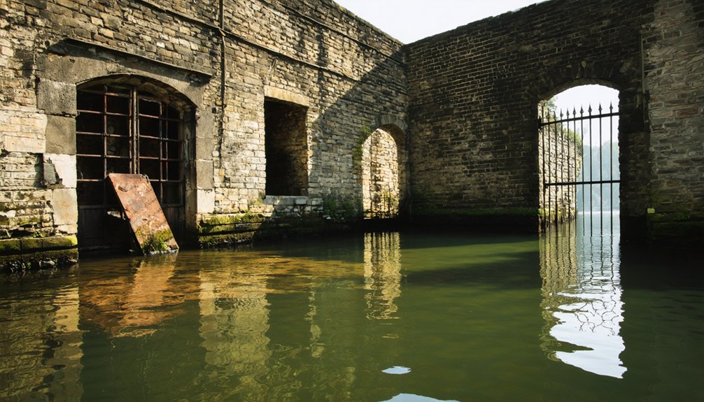
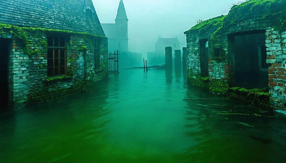
What Remains: Foundations and Forgotten Streets
During periodic drawdowns and drought conditions, the skeletal infrastructure of these drowned communities emerges from reservoir depths with surprising clarity. You’ll find roadways that once connected neighbors, foundations marking family homesteads, and street grids preserving settlement patterns from centuries past.
Water level records reveal these hidden artifacts cyclically—sometimes through planned maintenance, occasionally during severe droughts. Rock carvings from 1800s farming communities remain intact beneath the surface, while cemetery remnants persist despite relocation efforts.
When lakes drain for dam maintenance, you can trace original town layouts and examine structural bases that survived submersion.
What surfaces during drawdowns:
- Foundation outlines from settler-era homes and buildings
- Original roadway systems and street grid patterns
- Cemetery markers and grave sites inadequately relocated
- Rock carvings and historical inscriptions from early communities
- Farm land boundaries and property demarcations
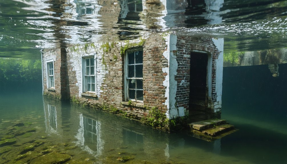
Exploring the Submerged Ruins Today
Modern reservoir management cycles have transformed these submerged settlements into accessible historical sites for dedicated explorers.
At Flagstaff Lake’s 20,000 acres, you’ll navigate exposed foundations and street outlines during drawdowns without guides restricting your access.
Scuba diving provides direct contact with submerged structures at depths reaching 327 feet in Summersville Lake’s crystalline waters, where Sarge’s Dive Shop equips independent expeditions.
The 2024 Youghiogheny drawdown revealed the 1818 Great Crossings Bridge for on-foot documentation—only the second exposure since flooding.
While historical myths and ghost legends persist around sites like Cherokee townsites beneath Tellico Lake, physical evidence contradicts supernatural claims.
You’ll need permission for Fontana Lake’s shoreline access, though pontoon boats offer unrestricted surface observation of Judson’s highest structural remnants during low-water periods.
Life Before the Flood: Stories From the Valley
Before federal dam projects reshaped northeastern waterways, thriving communities like Neversink and Bittersweet, New York, sustained 340 residents across 6,149 condemned acres until 1942 evictions cleared the reservoir site.
These valleys supported generations through historical agriculture and local legends passed through family homesteads. You’ll find documented evidence of 175 relocated buildings and 1,200 displaced gravesites—tangible proof of erased sovereignty over ancestral lands.
Community characteristics before displacement:
- 340 residents maintained independent agricultural operations across valley settlements
- Local legends and oral histories preserved multi-generational land stewardship knowledge
- Self-sufficient economy operated without federal infrastructure dependence
- 175 structures demonstrated permanent community investment and planning
- 1,200 cemetery plots evidenced deep-rooted family territorial claims spanning centuries
The systematic documentation reveals calculated removal of established populations for centralized water management objectives.
Other Vanished Settlements of the Region
While northeastern reservoir projects erased established communities through documented federal action, earlier settlements vanished under circumstances that continue challenging archaeological interpretation.
You’ll find Popham Colony’s 1607 Maine establishment lasted just one year before abandonment, yet its remains constitute a significant undisturbed archaeological site discovered nine years ago. The colony’s failure—stemming from harsh climate and poor Native alliances—influenced Plymouth’s strategic approach.
Meanwhile, Roanoke’s 1587 disappearance remains unsolved, though 2020 excavations uncovered colonial artifacts 50 miles from the original site, suggesting survivor dispersal.
Cape Ann presents a different erasure: indigenous settlements systematically destroyed since 1837 by looters and developers who removed shell heaps and burials, sending bones to anthropologists while historians falsely claimed Indians mysteriously “disappeared” rather than acknowledging deliberate displacement.
Frequently Asked Questions
Are There Other Underwater Ghost Towns in the Northeast Besides Flagstaff Lake?
You’ll find history sleeping beneath waves at Massachusetts’ Quabbin Reservoir, where four towns rest submerged. New York’s Catskill reservoirs—Neversink, Pepacton, Schoharie—offer archaeological discoveries during drawdowns, revealing foundations that challenge conventional historical preservation through aquatic documentation.
The allure of exploring sunken cities of New England draws historians and adventurers alike, as they seek to uncover stories hidden from the surface world. Each dive into these submerged realms unravels a tapestry of lost architecture and forgotten lives, enriching our understanding of the region’s past. These explorations not only highlight the impact of human development on the landscape but also serve as a reminder of the histories that lie beneath the water.
Can You Swim or Fish in Flagstaff Lake Above the Submerged Towns?
You’re free to swim and fish above the submerged towns at Flagstaff Lake. The freshwater ecosystem supports regulated fishing, while historical preservation efforts don’t restrict water activities. Exercise caution near submerged foundations during low-water periods for safety.
Were There Any Cemeteries Relocated Before the Valley Was Flooded?
Yes, you’ll find cemeteries were relocated before flooding—bodies moved, headstones transferred, graves exhumed. Relocation controversies challenged cultural preservation efforts as families faced forced decisions about ancestral remains, balancing water supply needs against your community’s sacred burial grounds and heritage rights.
Do Any Descendants of Displaced Residents Still Visit the Lake Today?
You’ll find limited documented descendant visits at Northeast sites, unlike St. Thomas Nevada’s family reunions. However, local legends persist among displaced families, and you’re free to explore shorelines during low water when submerged remnants become visible again.
Has Climate Change Affected Water Levels and Visibility of the Ruins?
You won’t find climate change “rebooting” these reservoir levels—dam operators control water heights for supply needs. Historical preservation remains submerged by design, not warming. Ecological impacts stem from managed drawdowns during droughts, exposing ruins temporarily without long-term climate-driven trends.
References
- https://wcyy.com/maine-underwater-ghost-town-flagstaff-lake/
- https://en.wikipedia.org/wiki/List_of_flooded_towns_in_the_United_States
- https://www.onlyinyourstate.com/nature/maine/lost-city-flagstaff-lake-me
- https://www.mainesnorthwesternmountains.com/things-to-do/sight-seeing-scenic-drives/the-valley-below
- https://darkdowneast.com/flagstafflake/
- http://www.pauldoiron.com/blog/2009/9/16/flooded-flagstaff.html
- https://www.youtube.com/watch?v=-nQLdB0Y8yo
- https://www.traceyourpast.com/newsletters/ghost-towns
- https://wvtourism.com/did-you-know-there-is-an-underwater-ghost-town-in-west-virginia/
- https://clui.org/newsletter/spring-2005/immersed-remains-towns-submerged-america


