You’ll find numerous submerged communities beneath Southern reservoirs, including North Carolina’s Fontana Lake (which flooded Proctor and Judson in 1945), South Carolina’s Lake Jocassee (covering 600 years of Cherokee settlements), and Lake Hartwell (submerging Andersonville’s 1801 trading hub). West Virginia’s Summersville Lake conceals Gad’s infrastructure, while Lake Marion preserves Ferguson’s lumber operations. These sites feature intact foundations, cemeteries, and stone structures—protected underwater and accessible through technical diving or seasonal drawdowns when water levels drop. Detailed documentation reveals preservation techniques and exploration opportunities across these historic locations.
Key Takeaways
- Multiple Southern towns submerged beneath reservoirs include Proctor in Fontana Lake, Judson, communities in Lake Jocassee, Andersonville in Lake Hartwell, and Gad.
- Lake Jocassee submerged over 600 years of Cherokee settlements; divers explore sites like Attakulla Lodge and Mount Carmel Cemetery underwater.
- Andersonville, destroyed by floods and submerged in 1962, features underwater stone foundations, chimneys, and a relocated cemetery accessible to divers.
- West Virginia’s Gad was relocated before Summersville Dam creation; underwater mill infrastructure remains attract divers while preventing millions in flood damage.
- Seasonal low water levels expose submerged structures like foundations and walls, enabling archaeological documentation and independent exploration of Southern heritage.
Fontana Lake’s Submerged Communities of Proctor and Judson
When the Tennessee Valley Authority completed Fontana Dam in 1945, it created a reservoir that permanently erased two established North Carolina communities from the landscape. Proctor and Judson, once-thriving towns along the Little Tennessee River’s tributaries, now rest beneath Fontana Lake’s 440-foot depths.
Fontana Dam’s completion in 1945 buried two North Carolina towns—Proctor and Judson—beneath 440 feet of water, erasing them forever.
You’ll find Proctor partially submerged, with scattered lumber mill remnants and relocated cemeteries marking what families lost. Judson vanished completely—structures, homes, and graveyards all consumed by the 1,703-foot elevation reservoir.
When lake levels drop seasonally, building foundations emerge as stark reminders of displacement. Over 1,300 families sacrificed their homesteads for wartime electricity production. The dam’s construction washed out Highway 288, the only main road serving Hazel Creek, permanently isolating the region from vehicle access. The North Shore Cemetery Association currently maintains and decorates 28 of these burial sites, preserving connections to the lost communities.
These submerged settlements have become local legends and haunted sites, where you can still access 35 cemeteries only by boat or backcountry hiking through what’s now Great Smoky Mountains National Park.
The Deep Waters of Lake Jocassee Hide Historic Structures
Technical divers can access three significant structures:
- Attakulla Lodge – A former riverside gathering place discovered by dive shop owner Bill Routh.
- Mount Carmel Cemetery – Filmed before flooding for “Deliverance.”
- Camp Jocassee for Girls – Located during underwater expeditions.
Before flooding displaced these communities, archaeological artifacts were recovered and preserved at The Museum of the Cherokee in Walhalla.
The 1785 treaty forced land cession, erasing irreplaceable heritage and regional identity beneath waters you’re now free to explore. The lake’s name itself comes from the Cherokee language, meaning “Place of the Lost One.” The Cherokee Lower Towns were submerged when the lake was created in 1973, ending over 600 years of settlement in this area.
Gad Community Beneath Summersville Lake’s Crystal Waters
Before Summersville Dam’s gates closed on September 3, 1966, the U.S. Army Corps of Engineers acquired and submerged Gad, a farming settlement established around 1889 along McKee’s Creek.
You’ll find this community preservation effort relocated six family graveyards before the 390-foot dam created West Virginia’s largest lake—2,790 acres covering generational homesteads, a general store, school, church, and sawmill.
The reservoir’s crystal-clear waters now attract scuba divers practicing underwater archaeology, exploring visible roadways, foundations, and rock carvings during winter draw-downs near the marina. The lake’s recreational appeal has earned it the nickname “Bahamas of the East Coast,” drawing visitors for swimming, fishing, boating, and snorkeling activities.
While flood control has saved $407,400,000 in Kanawha Valley damages, this “Appalachian Atlantis” represents forced displacement of tight-knit rural families.
Officials nearly named it “Gad Dam” before objections prevailed, yet the submerged town’s legacy persists beneath recreational waters. Former residents and descendants maintain deep emotional ties to the community that vanished beneath the lake’s surface.
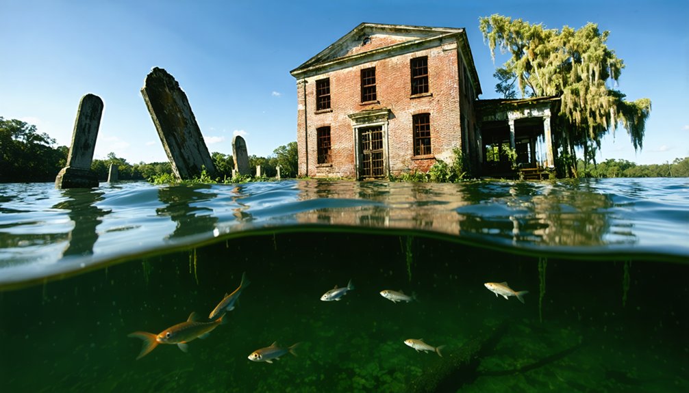
Andersonville’s Flooded Remains in Lake Hartwell
Established by South Carolina’s General Assembly in 1801, Andersonville developed at the strategic confluence of the Seneca and Tugaloo Rivers as a trading and textile center that would serve Anderson County for six decades.
Founded in 1801 at two rivers’ meeting point, Andersonville emerged as Anderson County’s vital commercial and manufacturing hub for sixty years.
Catastrophic floods in 1840 and 1852 destroyed its mills, while railroad expansion sealed its fate by 1893.
Lake Hartwell’s construction completely submerged the town by 1962.
You’ll find architectural preservation efforts limited beneath 60–90 feet of water, though underwater archaeology reveals:
- Stone foundations and chimneys beneath sediment layers
- Relocated cemetery remains at Andersonville Baptist Church
- Andersonville Island—a two-mile remnant accessible only by watercraft
Divers exploring these submerged ruins report weathered walls and structures, though visibility challenges restrict exhaustive documentation of this lost settlement’s physical evidence.
The town thrived in the lowlands along the Savannah River before the dam’s construction in the 1960s.
The Hartwell Dam was constructed to control flooding, generate hydroelectric power, and supply water to the region.
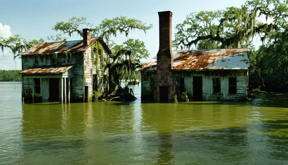
Ferguson’s Industrial Past Under Lake Marion
When Chicago entrepreneurs Francis Beidler and B.F. Ferguson acquired 165,000 acres of South Carolina’s Santee floodplain in 1881, they established an industrial marvel that would vanish beneath Lake Marion’s surface.
The Santee River Cypress Lumber Company built Ferguson—a self-contained town housing 400 workers with advanced amenities including indoor plumbing and gas lighting.
Their lumber technology featured a sophisticated band mill, Lidgerwood cableway system, and pile-supported railways extending into remote swamps.
Railroad remnants connected Ferguson to broader markets through the Eutawville Railroad branch.
Operations ceased in 1915 when oversupply collapsed the cypress market.
The 1930s Santee-Cooper hydroelectric project flooded 60,000 acres of company land, transforming this industrial site into an underwater ghost town.
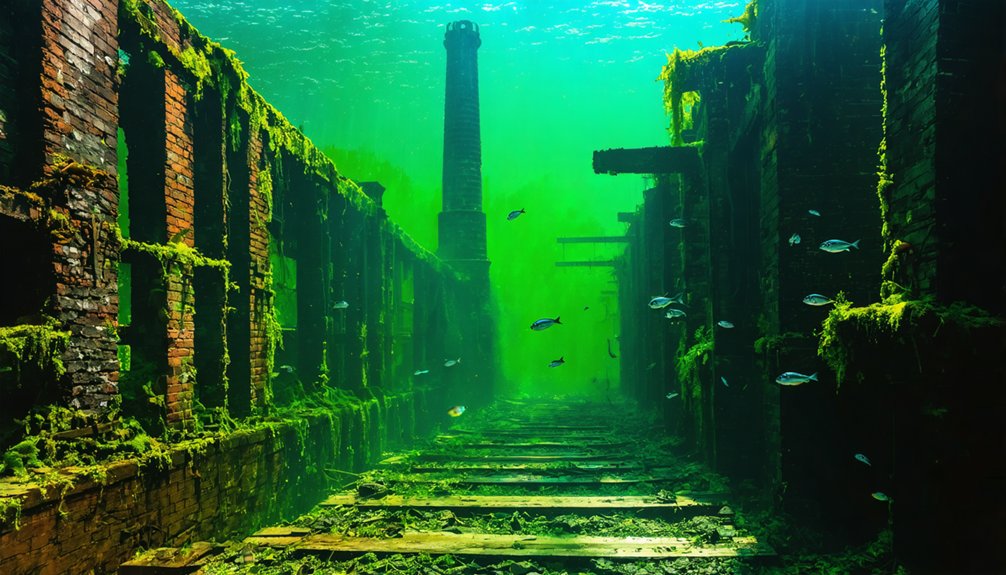
The construction led to abandoned cities submerged in water, their structures slowly decay beneath the surface. Fishermen now traverse the eerie waters, occasionally catching glimpses of old streets and buildings long forgotten. Each dive unearths remnants of a vibrant past, leaving a haunting reminder of what once thrived above the waves.
The phenomenon is not unique to Santee-Cooper, as there are numerous underwater ghost towns in Louisiana that tell a similar story of loss. These submerged communities, once alive with activity, now lie silent beneath the murky waters, their histories obscured by time and tide. Each area has its own narrative of change, inviting explorers to uncover the past buried deep within the swamps.
Mill fragments still pierce Lake Marion’s surface, marking where freedom-seeking laborers once extracted virgin timber.
The lake itself honors Revolutionary War hero Francis Marion, the “Swamp Fox” who conducted raids from the region’s cypress forests.
A steam locomotive known as Santee River Cypress #102 hauled 30-40 logging cars daily along the railroad line.
Saluda River Valley Towns Lost to Lake Murray
German, Swiss, and Dutch immigrants transformed the Saluda River Valley into a thriving agricultural corridor beginning in the early 1750s, establishing settlements like Dutch Fork and Saxe-Gotha township along the confluence of the Broad and Saluda Rivers.
By 1928, these floodplain settlements supported approximately 5,000 residents across nine towns before SCE&G’s dam project erased them from view.
River archaeology now reveals what you’d find beneath Lake Murray‘s surface:
- Intact 1800s stone house with preserved roof structure
- Worker-signed bridge foundations connecting former riverbanks
- Indian attack shelter converted to lock keeper’s residence
Technical divers Steve Franklin and John Baker employ sonar mapping to document submerged schools, churches, and 193 graveyards.
Descendants seeking ancestral graves rely on these precise underwater surveys documenting your accessible heritage.
Exploring Submerged Southern Heritage Through Diving and Drawdowns
Unlike surface archaeology where erosion destroys evidence, submerged towns preserve architectural details through water’s protective seal—but you’ll need specialized equipment to document them.
Water preserves what air destroys—submerged ruins remain frozen in time, waiting for those equipped to reveal their secrets.
Ferguson’s lumber kiln foundations and St. Thomas’s forty exposed buildings demonstrate how reservoir drawdowns grant access without government-imposed restrictions.
You can explore Andersonville Island’s remnants during low-water periods, while Fontana Lake’s clarity permits diving expeditions to Proctor’s ruins.
Historical preservation depends on your photographic documentation before silt accumulation obscures structural details.
Environmental impact studies reveal that seasonal water-level fluctuations naturally expose sites like Loyston’s trading center foundations along former Highway 61.
These accessible underwater archaeological sites offer unrestricted opportunities for independent research, allowing you to chronicle Southern heritage without bureaucratic interference or institutional gatekeeping.
Frequently Asked Questions
What Permits Are Required to Dive or Explore Underwater Ghost Towns?
You’ll need sanctuary permits for historical preservation in protected waters, plus standard dive certifications ensuring diving safety. Ironically, regulations protecting these submerged ruins actually grant you freedom to explore responsibly where unregulated sites often close permanently due to damage.
How Do Flooding and Dam Construction Affect Local Property Values Today?
Flooding reduces your property values by 4-12% through environmental impacts like increased insurance costs and buyer hesitation. Historical preservation efforts can’t offset climate-driven risks, as repeated events create lasting stigmatization that extends depreciation for years.
Were Residents Compensated Fairly When Towns Were Condemned for Dam Projects?
Compensation varied widely, but you’ll find most wasn’t fair by today’s standards. Historic preservation and environmental impact weren’t priorities—residents received minimal payments, forced relocations destroyed communities, and many graves remain submerged without proper documentation or restitution.
What Artifacts Have Divers Recovered From These Submerged Southern Communities?
You’ll find divers haven’t recovered artifacts due to underwater archaeology regulations protecting these sites. Artifact preservation laws restrict removal, ensuring historical integrity remains intact. These submerged communities stay protected, allowing you documented observation rights without disturbing cultural resources.
Can Descendants Still Visit Family Graves in These Flooded Locations?
You’ll find access varies—some graves you can visit, some you can’t reach, some don’t exist anymore. Historical preservation efforts relocated 2,300+ graves at Toledo Bend, maintaining cultural significance through exact cemetery replication for your continued family connections.
References
- https://www.blueridgeoutdoors.com/go-outside/sunken-secrets-the-underwater-ghost-towns-of-the-blue-ridge/
- https://wvtourism.com/did-you-know-there-is-an-underwater-ghost-town-in-west-virginia/
- https://www.thewanderingappalachian.com/post/the-underwater-towns-of-appalachia
- https://texashighways.com/culture/history/the-lost-underwater-towns-of-texas/
- https://www.randomconnections.com/the-ghost-towns-of-lake-marion/
- https://www.youtube.com/watch?v=T6gy0y6XFAo
- https://en.wikipedia.org/wiki/List_of_flooded_towns_in_the_United_States
- https://www.youtube.com/watch?v=zm8DWqIZf0s
- https://www.atlasobscura.com/places/proctor-lost-ghost-town-hazel-creek
- https://www.explorebrysoncity.com/the-history-of-the-road-to-nowhere-in-swain-county/


