You’ll find dozens of ghost towns submerged beneath Southwest reservoirs, flooded during the federal government’s 1930s dam-building projects. St. Thomas, Nevada lies under 70 feet of Lake Mead water since 1938, while Kennett, California rests beneath 400 feet of Lake Shasta. Old Bluffton, Texas disappeared under Lake Buchanan’s 30 feet in 1937. During droughts, receding water levels expose foundations, streets, and cemeteries—creating rare windows to explore these sacrificed communities. The ruins, documentation methods, and访问 opportunities reveal how massive infrastructure projects permanently reshaped the region’s cultural landscape.
Key Takeaways
- Multiple Southwestern towns like St. Thomas, Nevada and Old Bluffton, Texas were intentionally flooded during 1930s dam construction projects.
- St. Thomas sits under 70 feet of Lake Mead water; ruins visible since 2002 drought revealed foundations and streets.
- Old Bluffton, Texas submerged under 30 feet of Lake Buchanan in 1937; remains appear when water drops 20 feet.
- Kenne, California, once home to 10,000 residents, now lies 400 feet beneath Lake Shasta after government dam projects.
- Fluctuating reservoir levels expose artifacts, foundations, and cemeteries, creating temporary windows for public exploration and archaeological documentation.
Old Bluffton, Texas: A Town Beneath Lake Buchanan
Old Bluffton, Texas established its foundations in 1852 when Billy Davis arrived from Arkansas Territory and settled along the west bank of the Colorado River. You’ll find this Hill Country settlement was renamed Bluffton in 1854, thriving with fifty families cultivating pecan orchards and cotton fields.
The town’s fate changed when Buchanan Dam construction began in 1931 as a New Deal flood management project. LCRA acquired land through purchase or condemnation, creating a 22,000-acre reservoir. The dam project created over 20,000 jobs during the Great Depression before its completion in 1937. Excess rainfall exceeding 20 inches caused the lake to rise to capacity within months, rapidly flooding the abandoned town.
Historical preservation efforts salvaged 100-200 graves before Lake Buchanan’s waters submerged the town under thirty feet. You can access Old Bluffton‘s ruins during droughts when water levels drop twenty feet below capacity, revealing foundation stones and structural remnants of this submerged community.
St. Thomas, Nevada: Lake Mead’s Vanished Mormon Settlement
The Hoover Dam’s completion in 1935 created Lake Mead, submerging St. Thomas by 1938 under up to 70 feet of water after the federal government purchased the settlement under the Boulder Dam Act of 1928.
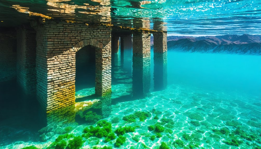
You’ll find that severe drought conditions in the early 2000s caused Lake Mead’s water levels to recede markedly, exposing the town’s ruins in the Overton Arm for the first time in over six decades. The National Park Service has paved a trail to the site and installed educational signs for visitors.
The site now stands approximately 6,000 feet from the current shoreline, serving as both an archaeological resource and a visible indicator of the Colorado River Basin‘s ongoing water crisis. Mormon pioneers originally founded the settlement in 1865 while seeking fertile land, but abandoned it in 1871 due to high taxes before it was resettled by miners and ranchers who helped it thrive until the dam’s construction.
Hoover Dam Floods Town
When Mormon settlers arrived in January 1865 under Brigham Young’s directive, they established St. Thomas near the Virgin and Muddy Rivers confluence.
The town persisted through territorial disputes, mass abandonment in 1871, and successful resettlement in the 1880s, reaching 500 residents by the early 1900s.
Railroad construction (1911-12) and Arrowhead Trail designation (1913) positioned St. Thomas as a viable desert community.
The 1930s Hoover Dam construction, designed for hydroelectric power generation, sealed the town’s fate.
Lake Mead’s reservoir would submerge St. Thomas entirely.
You’ll find residents evacuated completely by June 11, 1938, when Hugh Lord departed.
The cemetery relocated to Overton.
The community’s economy had included agriculture alongside silica and salt mining operations that supported local prosperity.
The settlement’s name honored Saint Thomas, following the Mormon tradition of using religious designations for new communities in the American Southwest.
Today, structural preservation efforts by the National Park Service protect exposed ruins during low-water periods, documenting this sacrificed settlement 60 miles east of Las Vegas.
2002 Drought Reveals Ruins
Lake Mead’s water levels began their precipitous decline in the early 2000s, exposing St. Thomas’s submerged ruins after seventy years underwater. You’ll find building foundations, chimneys, and street layouts emerging as drought conditions persist.
The National Park Service documented this phenomenon, establishing the site as protected archaeological territory within Lake Mead National Recreation Area.
Climate change and inadequate water conservation policies accelerated the reservoir’s retreat, dropping levels from their historic 70-foot depth over the ruins.
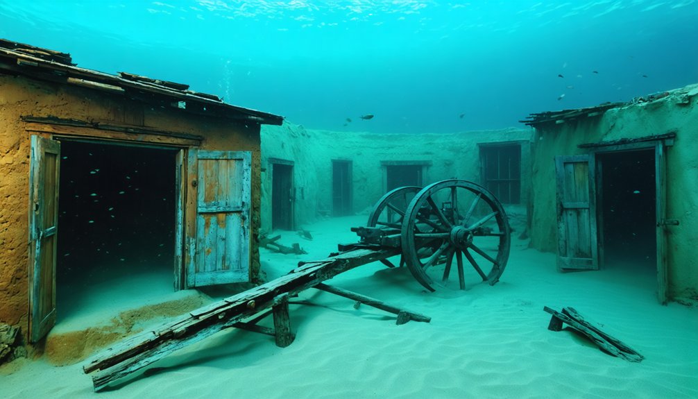
You’re now free to explore former streets where Mormon settlers once cultivated cotton and corn. The site is accessible by traveling south on SR 169 from I-15, then following Old St. Thomas Road approximately three miles to reach the parking area. The Lost City Museum in Overton maintains extensive documentation from the 1930s submersion, while interpretive signage guides your investigation of this reappeared settlement’s architectural remnants and community infrastructure. The town’s peak population of 500 residents had established a thriving community before being forced to relocate in 1871.
When Droughts Reveal Hidden History
When Lake Mead’s water level dropped 70 feet below its historical peak in 2002, St. Thomas’s adobe walls and cisterns emerged after 64 years of submersion, creating documented access points for archaeological study.
You’ll find similar patterns at Lake Altus-Lugert in Oklahoma, where extreme drought conditions expose brick foundations and structural remnants of the 1901 settlement. These periodic exposures provide time-limited windows—measured in months or years depending on precipitation cycles—for researchers and visitors to document architectural features before water levels rise again. The town’s remains lie within Lake Mead National Recreation Area, where park service preservation efforts now protect the exposed foundations and artifacts. Lugert’s submersion resulted from dam construction that began in 1926 and concluded in 1947, transforming the North Fork of the Red River valley into a reservoir that would supply water to the region for decades to come.
Receding Waters Expose Ruins
Drought conditions transform submerged landscapes into archaeological windows, exposing settlements that have remained hidden beneath reservoir surfaces for decades. You’ll witness lakebed ecosystems revealing century-old structures when water level management fails during severe droughts.
In 2009, Lake Buchanan dropped to 26 feet, exposing Old Bluffton’s foundations after 72 years underwater. Lake Altus-Lugert’s 2015 recession to 9 percent capacity unveiled Lugert’s tornado-resistant general store remnants.
When you explore these sites, you’ll discover:
- Cotton gin machinery standing where farmers once processed their harvests
- Cemetery headstones marking graves of freed slaves, their stories preserved in limestone
- Storm cellars and cisterns containing artifacts from daily frontier life
These exposures grant you unrestricted access to historical evidence that government reservoirs typically conceal.
Archaeological Excavation Opportunities
As reservoir levels decline across the Southwest, archaeologists gain unprecedented access to submerged cultural sites that standard excavation methods can’t reach.
You’ll find researchers deploying drones and 3-D imaging at Pueblo Grande de Nevada, documenting structures before further erosion destroys evidence.
The St. Thomas Interpretive Center‘s staff archaeologist conducts systematic studies of settlement patterns, examining foundations exposed after decades underwater.
Ancient artifacts emerge from sites like the 100-room complex near Overton, occupied by Anasazi and Pueblo peoples over 1,000 years ago.
While underwater preservation protected these materials from typical degradation, exposure now creates urgency.
Archaeologists race against vandalism, unauthorized trails, and environmental damage.
These revealed landscapes offer you rare glimpses into pre-contact lifeways, irrigation systems, and architectural sophistication—evidence you’d never access through conventional dig sites.
Temporary Access for Visitors
Receding reservoir levels across the Southwest create limited windows for public access to submerged ghost towns, with visibility duration dependent on sustained drought conditions and water management policies.
Exploring the ghost towns of the desert southwest offers a unique glimpse into the past, revealing stories of communities once vibrant but now quiet and forgotten. As the water recedes, these remnants become accessible, drawing adventurers and historians eager to uncover their mysteries. However, with climate variability and changing policies, the opportunity to experience these fleeting sites may soon disappear again.
You’ll find these rare opportunities at accessible sites where water level fluctuations expose decades-old foundations and artifacts preservation remains challenging.
National Park Service marks receding water lines, while rock color differences reveal the extent of water drops.
Your exploration options include:
- St. Thomas at Lake Mead—accessible via 3-mile dirt road with online directions to foundations exposed since 2002
- Mormon Island at Folsom Lake State Recreation Area—partial remains available for examination since 2013
- Whiskey Flats near Kernville—foundations, old trees, and everyday items visible at 8% capacity
Each site offers unrestricted viewing of pre-flood artifacts from various historical eras.
The Hoover Dam’s Lasting Legacy

When Six Companies, Inc. broke ground in 1931, they initiated what would become one of America’s most ambitious infrastructure projects—a $49 million undertaking that employed 21,000 men over five years and consumed 4.36 million cubic yards of concrete.
You’ll find this dam generates 4 billion kilowatt-hours annually, powering 1.3 million people across Nevada, Arizona, and California while irrigating 1.5 million acres. The project’s revenue repaid its construction costs with interest by 1987.
However, ecological impacts remain significant—submerged communities and altered river ecosystems demonstrate infrastructure’s lasting consequences. Cultural preservation efforts can’t recover what’s lost beneath Lake Mead’s surface.
The dam’s 1995 structural tests confirm concrete strength exceeds specifications, ensuring this monument to Depression-era engineering endures while the ghost towns below remain inaccessible.
Kennett, California and Other Forgotten Communities
Beneath Lake Shasta’s surface, approximately 400 feet of water now conceals what was once California’s prosperous copper mining hub of Kennett.
You’ll find deep water covering a community that reached 10,000 residents during WWI’s copper boom, only to face demolition without public hearings before Shasta Dam’s 1935 construction.
A thriving 10,000-person copper town demolished without public input, sacrificed to federal dam construction and rising waters.
The federal government’s modern infrastructure project erased:
- An incorporated town with schools, hospitals, and 40 saloons that thrived from 1911-1931
- The Mammoth Copper Company’s operations including smelters and railroad connections
- Residents’ property rights as families sold land and watched waters rise in 1944
Documentary evidence and archival photographs preserve what bulldozers couldn’t destroy.
Kennett rests one mile north of Shasta Dam, alongside submerged towns Copper City, Elmore, and Pitt—communities sacrificed for centralized water control.
Visiting Submerged Ghost Towns Today
Today’s fluctuating reservoir levels grant unprecedented access to communities federal dam projects submerged decades ago. You’ll find St. Thomas, Nevada most accessible—a 1-mile desert walk from Overton reveals foundations, schoolhouse ruins, and Hannag Ice Cream Parlor since 2002’s drought exposure.
Lake Texoma’s 2011-2012 low water exposed Hagerman and Cedar Mills gravestones along Red River arms, creating impromptu maritime archaeology sites.
You can explore Andersonville Island in Lake Hartwell’s center by watercraft, documenting textile town remnants amid altered underwater ecosystems.
Lake Altus-Lugert’s receding shoreline reveals Lugert’s brick foundations and tornado-survivor debris piles.
These sites exist outside typical recreational restrictions, letting you witness how reservoir construction reshaped regional landscapes—though unidentified cemetery locations remain submerged, inaccessible to descendants.
Frequently Asked Questions
Are There Any Underwater Ghost Towns in Arizona or New Mexico?
You’ll find three underwater ghost towns: Arizona’s Alamo Crossing lies preserved 80 feet beneath Lake Alamo, while New Mexico’s Bonito Lake and Navajo Lake sites demonstrate environmental impact from damming, offering unique historical preservation through submersion rather than decay.
exploring the depths of California’s lakes reveals lost towns beneath California’s waters, telling stories of communities once vibrant and now silent. These submerged sites hold relics of another time, inviting adventurers and historians alike to uncover their secrets. As divers navigate through the murky depths, they can glimpse the remnants of buildings and streets that hint at the lives that were once lived above the surface.
Can Scuba Divers Legally Explore the Submerged Ruins of These Towns?
You’ll face strict federal restrictions on most sites. Legal exploration requires permits, proof of diving safety certification, liability waivers, and ranger supervision. Marine conservation laws protect submerged archaeological zones, limiting your freedom to independently dive these Southwest ghost towns.
What Happened to Residents Who Refused to Leave Before Flooding?
Historical records show you won’t find documented cases of residents refusing evacuation—government acquisition programs systematically purchased properties before flooding. Water level impact became inevitable once communities accepted compensation, though historical evacuation challenges weren’t recorded.
Do Any Original Buildings Still Have Intact Roofs or Interiors Underwater?
No intact roofs remain underwater due to wood degradation over decades. You’ll find only foundations and partial walls during low-water archaeological access. Diving safety restrictions and preservation techniques prevent underwater exploration, limiting documentation to drought-exposed structural remnants.
Could These Towns Ever Be Permanently Restored if Water Levels Drop?
You won’t see permanent restoration—St. Thomas’s 2002 reemergence proved temporary. Environmental impact demands reservoir operation, while archaeological preservation designates sites like Mormon Island as protected ruins, not resettlement zones. Federal ownership legally prevents repopulation of these submerged properties.
References
- https://www.atlasobscura.com/places/old-bluffton-underwater-ghost-town
- https://mikesroadtrip.com/st-thomas-nevada/
- https://www.youtube.com/watch?v=QNEIN5aixdA
- https://clui.org/newsletter/spring-2005/immersed-remains-towns-submerged-america
- https://www.youtube.com/watch?v=2VbtuvkJCAM
- https://en.wikipedia.org/wiki/List_of_flooded_towns_in_the_United_States
- https://www.buchananlaketexas.com/news–entertainment–Ghost-Town-Under-Lake-Buchanan-Old-Bluffton/7262
- https://101highlandlakes.com/haunted-highland-lakes-old-bluffton-an-underwater-ghost-town/
- https://www.youtube.com/watch?v=x1VRUi_TwoY
- http://wideurbanworld.blogspot.com/2012/12/old-bluffton-ghost-town-rises-from-lake.html


