You’ll find several submerged ghost towns beneath Washington’s reservoirs, deliberately flooded between 1914 and 1944 for dam construction. Moncton lies under Rattlesnake Lake after a 1915 dam failure, while Old Marcus sits beneath Lake Roosevelt following the Grand Coulee Dam’s completion in 1940. Old Alder disappeared under Alder Lake in 1944. During seasonal drawdowns and drought periods, foundations, street grids, sidewalks, and artifacts become visible—including concrete ruins, machinery, and personal belongings. Timing your visit with low-water cycles reveals these preserved remnants of Washington’s engineered flooding history.
Key Takeaways
- Multiple Washington towns were submerged by dam projects, including Moncton (1915), Old Marcus (1940), and Old Alder (1944).
- Lake Roosevelt alone submerged eleven communities in the 1930s-40s, with visible remnants during seasonal water level drawdowns.
- Moncton flooded after a dam failed on unstable ground, with engineers witnessing houses “floating like corks.”
- Seasonal drawdowns and droughts expose foundations, sidewalks, artifacts, and street grids at sites like Marcus and Rattlesnake Lake.
- Spring and fall low-water periods offer optimal visibility for exploring submerged ruins, foundations, and historical artifacts.
Moncton: A Railroad Town Lost to Dam Leaks
When the Chicago, Milwaukee & St. Paul Railway established Moncton in 1906, settlers built their privately-owned homes along Rattlesnake Lake’s northern shore—a distinction that attracted workers seeking autonomy from company towns.
By 1915, over 200 residents occupied this thriving community. Everything changed when Seattle City Light completed the Cedar River Masonry Dam in October 1914.
Springs burst through porous rock faces as reservoir pressure mounted, and Rattlesnake Lake flooded the settlement. The glacial moraine underneath acted like a sponge, allowing dam seepage to redirect water into the lake basin.
Historical photographs document the town’s systematic submersion through summer 1915. You’ll find local storytelling reveals how residents watched their homes literally float away before Seattle condemned the site, paying $47,658.03 in total compensation.
On low-water days, you can observe remnants beneath the lake’s surface—tangible evidence of engineering failure. The dam was constructed 1.5 miles below an earlier timber crib dam that had successfully generated electricity for Seattle since 1905.
Old Marcus: Drowned by the Grand Coulee Dam
While Rattlesnake Lake’s flooding resulted from engineering miscalculation, Old Marcus fell victim to deliberate federal infrastructure development. This Stevens County steamwheeler hub served miners extracting hundreds of thousands in ore value before Grand Coulee Dam’s 1940 completion submerged it beneath Lake Roosevelt’s waters.
Old Marcus surrendered to progress—a thriving mining hub deliberately erased beneath federal waters when Grand Coulee Dam sealed its fate.
The town’s urban decay wasn’t gradual—WPA and CCC workers systematically stripped buildings, relocated graves, and cleared timber before geological shifts created by rising reservoir waters erased the townsite entirely. The reservoir transformed 150 miles of free-flowing river into a storage system that drowned acres of timber, farmland, and Indian villages.
You’ll witness Marcus’s remnants during spring drawdowns when operators lower the lake for flood control:
- Sidewalks and foundations emerge from sediment
- Street grids become visible through shallow water
- Sand and rock formations reveal original topography
The 2023 April drawdown exposed this bureaucratic sacrifice to hydroelectric power generation. Today, a new town named Marcus sits on a bench above the original flooded site, preserving the name but lacking the historical character of its predecessor.
Old Alder: Sacrificed for Hydroelectric Power
How does a logging town of 200 residents vanish in service of wartime power demands? You’ll find the answer beneath Alder Lake‘s surface, where Old Alder disappeared in 1944.
Tacoma’s municipal power authority evacuated residents in 1942, relocating buildings before flooding commenced. The Alder Dam created a seven-mile reservoir reaching 1,205 feet elevation, drowning streets, businesses, and homes forever.
When late-summer drawdowns expose the lakebed, you’ll discover submerged artifacts documenting frontier life: Model A engine blocks, ladies’ shoes, rusty machinery scattered among building foundations.
The schoolhouse ruins crown a central hill—two massive pillars marking what citizens abandoned. Underground pipes from the business district protrude through mud. Explorers document these historic locations with photography and video, preserving stories that would otherwise vanish beneath the water’s surface.
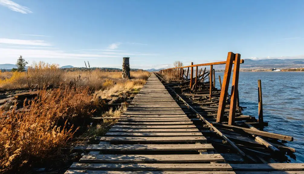
An old railroad trestle emerges near waterline, monument to infrastructure sacrificed when wartime necessity demanded hydroelectric capacity over community preservation. Only three original buildings survived the flood, including a Presbyterian church built in 1904 and relocated near the current Alder site.
The Masonry Dam Disaster of 1915
A $1.4 million gamble against geological reality transformed Moncton into Washington’s most preventable ghost town disaster. You’ll find compelling evidence in the 1915 engineering failure that created Rattlesnake Lake. Despite geologist warnings about unstable glacial moraine, voters approved dam construction in 1912.
The unconsolidated debris functioned as pressurized conduit:
- December 1914: Water storage initiated immediate north bank seepage.
- April 1915: Mini-geysers erupted through clear-cut hillsides as springs burst.
- Summer 1915: Entire town submerged, houses floating “like corks.”
Seattle condemned the settlement for $47,658.03. Today’s underwater archaeology and sediment analysis reveal waterlogged structural remains beneath fluctuating lake levels.
The North Bend Lumber Company’s 1919 lawsuit secured $361,867.81 after devastating 1918 washouts. Three years earlier, Superintendent James D. Ross had initiated the ambitious Skagit River hydroelectric project that would eventually supply power to Seattle starting in 1924. The masonry dam, constructed over four years beginning in 1914, had replaced the original timber crib dam from 1902. No casualties occurred despite complete submersion.
Lake Roosevelt’s Sunken Communities
When you examine Lake Roosevelt behind Grand Coulee Dam, you’re observing eleven former towns and settlements submerged during 1930s construction that transformed 150 miles of the Columbia River into a reservoir.
The most accessible ghost town evidence appears at Marcus, where foundations, sidewalks, and street infrastructure emerge during spring drawdowns—operational water level reductions designed to accommodate snowmelt runoff.
These seasonal exposures reveal archaeological features including foundation slabs and building remnants that typically remain submerged beneath the reservoir’s 100,000-acre surface. Among the submerged communities, Kettle Falls was both a town and a geographical waterfall that now lies beneath Lake Roosevelt. Peach, situated at the Columbia River’s sandy bottom near Hawk Creek’s confluence, became the first and lowest town to be cleared and inundated, with residents forced to vacate by January 1, 1939.
Grand Coulee Dam Construction
The government’s acquisition program required:
- Purchase of nearly 7,000 town lots, railways, and factories.
- Demolition or relocation of more than 5,000 buildings.
- Exhumation and reinterment of burial grounds to higher elevations.
You’ll find that most communities—Keller, Lincoln, Gifford, Daisy, Kettle Falls, Marcus, Boyds, and Inchelium—relocated before the 1939 deadline.
However, Peach and Jerome disappeared entirely, their residents scattered after government-mandated evacuation.
Spring Drawdown Visibility
Once those displaced communities settled into their new locations, Lake Roosevelt began its annual cycle of revealing what remained behind. Each spring, you’ll observe the reservoir drop as managers create capacity for mountain snowmelt runoff. This drawdown prevents Columbia River flooding while generating hydroelectric power and supporting endangered fish species downstream.
The process dramatically alters lake ecology, exposing foundations, sidewalks, and streets at Marcus Island’s south end for days or weeks. You’ll find concrete slabs and structural bases emerging from sediment deposition accumulated over decades.
On April 16, 2023, particularly deep drawdown revealed extensive remnants of Marcus, Peach, Inchelium, and eight other agricultural communities submerged since the 1940s. These ghost towns remain underwater most months, surfacing only when operational demands require significant water release.
Marcus Town Remnants
At the south end of Marcus Island, concrete foundations and sidewalk systems emerge from accumulated sediment during seasonal drawdowns, providing physical evidence of a settlement that served as the region’s primary transportation hub from 1863 until its forced relocation in 1940.
The historical settlement’s infrastructure remains intact beneath Franklin D. Roosevelt Lake’s waters, alongside Indigenous sites that were similarly inundated during Grand Coulee Dam’s construction in the 1930s.
Archaeological features visible during spring reservoir drawdowns include:
- Concrete building foundations from commercial and residential structures
- Intact sidewalk networks marking the original street grid pattern
- Transportation infrastructure remnants from Marcus’s role as a stern-wheeler terminus
These remnants have remained periodically accessible for 60 years, offering tangible documentation of communities sacrificed for hydroelectric development.
When the Waters Recede: Seasonal Visibility Patterns
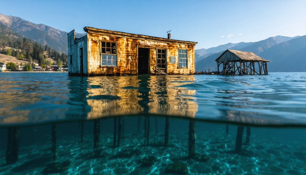
During prolonged winter droughts, Rattlesnake Lake’s water levels drop dramatically, exposing the concrete foundations and brick fireplaces of Moncton beneath its surface. December 2023 marked record lows after months of insufficient precipitation, according to watershed observations.
You’ll find these conditions intensifying as warmer, drier summers extend into traditional wet seasons, fundamentally altering aquatic ecosystems and water chemistry cycles.
The submerged town—flooded in 1915 when the Masonry Dam’s construction triggered springs through porous rock valleys—resurfaces when nature permits. Recent drought patterns mirror historical 1915 conditions but stem from climate shifts rather than engineering failures.
You can access chopped stumps, house foundations, and artifacts during these exposure windows. Watershed data confirms decades of rising and falling cycles, with current trends favoring extended low-water periods that grant unprecedented access to Cedar Falls’ drowned remnants.
Exploring the Rattlesnake Lake Recreation Area
Seattle Public Utilities maintains Rattlesnake Lake Recreation Area as a 111-acre non-development buffer zone outside the Cedar River Municipal Watershed‘s hydrologic boundaries, though the watershed itself supplies 65% of unfiltered drinking water to nearly 800,000 residents across the Seattle region.
You’ll find unrestricted access dawn to dusk year-round at this day-use area, located three miles southeast of North Bend via I-90 exit 32.
Current regulations permit:
- Gas BBQs on non-flammable surfaces only
- Private gatherings under 30 people (special permitting suspended August 2025)
- Boating, fishing, and swimming in spring-fed waters
The submerged townsite generates persistent urban legends and ghost stories among visitors.
Drone operations remain prohibited within this buffer zone protecting Seattle’s primary water supply from potential contamination.
Remnants and Artifacts Left Behind
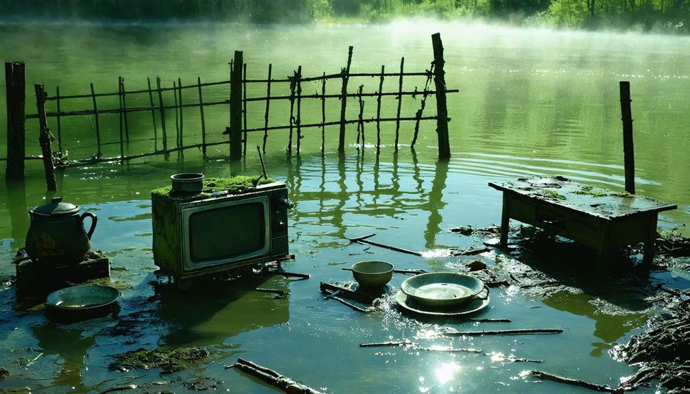
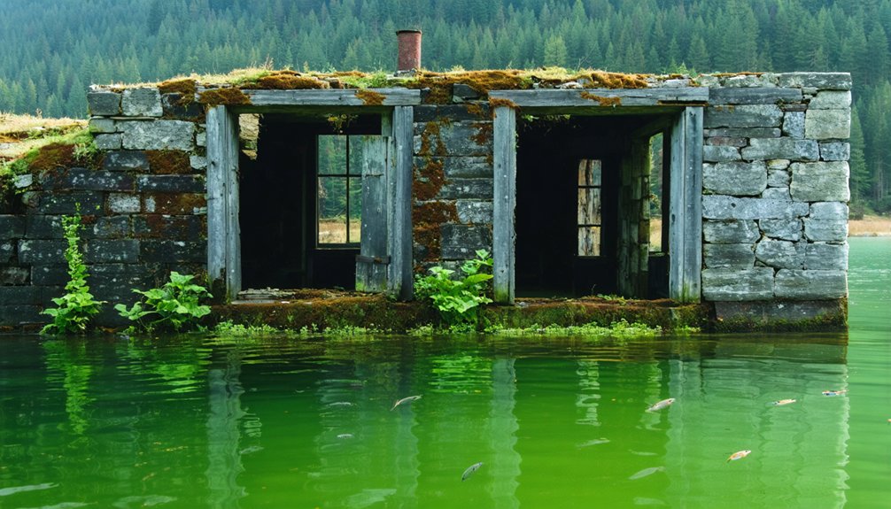
Beneath Rattlesnake Lake’s surface, you’ll encounter physical evidence of Old Alder’s abrupt 1918 abandonment. The schoolhouse’s stone foundation features two massive pillars marking its entryway, while rusted underground pipes connect the former business district.
You’ll spot ladies’ shoes from bygone eras near the waterline and a Model A Ford engine block breaking the surface. The railroad trestle’s cement posts and heavy gauge wire guardrails remain visible at the lake’s lowest points, though erosion threatens their complete disappearance.
Within accessible mine tunnels, century-old drill bits remain in situ alongside whiskey barrels rigged for water capture. Original timbers and ventilation systems survive in waist-deep, water-filled passages.
This submerged archaeology coexists with underwater biodiversity, creating unique documentation challenges before wildfires, vandalism, and time erase these remnants forever.
Other Forgotten Towns Beneath Washington’s Lakes
Washington’s hydroelectric ambitions created multiple submerged settlements beyond Rattlesnake Lake‘s well-documented case. You’ll find forgotten communities across the state where dams and reservoirs claimed entire townsites:
- Moonax in Klickitat County – Railroad station submerged beneath reservoir waters around 1940, its depot and infrastructure now hosting submerged artifacts accessible only through archival records.
- Almota in Whitman County – Ghost town at Almonta Creek’s Snake River confluence, where rising waters erased this once-thriving settlement.
- Lake Washington’s earthquake legacy – Ancient Seattle Fault slides created underwater forests spanning both Lake Washington and Lake Sammamish.
Their submerged flora is preserved alongside 400 downed boats and industrial equipment.
These sites represent governmental infrastructure projects that permanently displaced communities, trading human settlements for centralized power generation.
Planning Your Visit to See the Submerged Ruins
You’ll need to time your visit strategically, as water levels directly determine ruin visibility—target fall months or drought periods when reservoirs reach seasonal lows.
Access varies considerably by site: Rattlesnake Lake offers paved paths suitable for casual hikers, while Alder Lake’s island ruins require watercraft at high levels or scrambling over exposed lakebed at low points.
Bring sturdy footwear for uneven terrain, navigation tools for unmarked areas, and check current reservoir levels through local reports before departing.
Best Times for Viewing
Timing your expedition to Washington’s submerged ruins requires understanding the specific hydrological and tidal patterns that govern visibility at each location.
Optimal Viewing Windows:
- Winter Droughts (October-February): Rattlesnake Lake’s dramatic water level drops expose Moncton’s foundations, stumps, and fireplaces. Historic lows reveal structures from lakeshore trails, with visibility peaking during recent record-low years.
- Extreme Low Tides (Year-round negatives): Coastal erosion and lighthouse history sites become accessible during -2 feet tides. Dawn timing at Cape Disappointment and Long Beach Peninsula maximizes safe exploration before rising waters.
- Storm Season (November-March): Pacific storms generate high waves and king tides, amplifying coastal features. January’s sun-moon-Earth alignment produces peak tides, while fewer crowds optimize unobstructed viewing of wave-highlighted ruins and ghost forests.
Trail Access and Difficulty
Since water levels dictate accessibility more than traditional trail difficulty ratings, planning your approach to Washington’s submerged ruins requires monitoring hydrological conditions rather than evaluating elevation gain or terrain challenges.
You’ll find Rattlesnake Lake offers paved paths and straightforward lakeshore routes when Moncton’s foundations emerge during fall drawdowns.
Alder Lake provides direct walking access through the former business district, with the schoolhouse island featuring stone foundations that inspire local urban legends and folklore.
Lake Roosevelt’s Marcus townsite presents seasonal navigation opportunities during spring drawdown cycles, exposing streets and sidewalks.
Riffe Lake’s Kosmos remains requires coordination with recreation area management due to limited trail designation.
Physical exertion levels stay minimal; your primary challenge involves timing visits when reservoir operations expose these historically significant sites.
What to Bring Along
Successful exploration of Washington’s submerged ghost towns demands methodical preparation across five equipment categories: protective clothing, timing tools, navigation gear, documentation instruments, and environmental supplies.
You’ll need waterproof boots and quick-dry layers for variable lakeshore conditions. Polarized sunglasses help spot submerged cultural heritage features during low-water periods.
Essential documentation equipment includes:
- Waterproof camera for photographing foundations and structural remnants
- GPS device for precise artifact location marking
- Trash bags to minimize environmental impact by removing debris
Pack water level charts and smartphone apps tracking reservoir drawdowns to optimize timing.
Navigation essentials include detailed Rattlesnake Lake maps, compass, first-aid kit, and emergency whistle.
Don’t forget life vests for boat access, sunscreen, insect repellent, and adequate hydration supplies for multi-hour expeditions.
Frequently Asked Questions
Can You Scuba Dive or Snorkel to Explore the Submerged Ghost Towns?
You can’t scuba dive or snorkel these sites—they’re restricted for historical preservation. Underwater exploration isn’t permitted at Rattlesnake, Alder, Riffle Lakes, or Lake Roosevelt. You’ll access remnants only through surface viewing during documented low-water periods when townsites emerge.
Were Residents Compensated When Their Towns Were Flooded for Dam Projects?
Residents received compensation through federal land acquisitions, though no uniform standards existed. You’ll find economic impacts varied considerably, with buyouts and extensions granted inconsistently. Historical preservation wasn’t prioritized—power generation superseded community rights and documentation of displaced families’ losses.
Are There Any Human Remains or Graves Still Underwater in These Towns?
Grand Coulee’s Peach and Jerome potentially contain undisturbed graves underwater, though aquatic archaeology hasn’t confirmed this. Other sites show no documented human remains, but tidal erosion and incomplete historical records mean you can’t entirely rule out their presence.
Is It Legal to Take Artifacts Found at the Submerged Town Sites?
No, you can’t legally take artifacts from these submerged sites. Artifact theft carries serious legal ramifications: misdemeanor fines ($500-$5,000) for minor items, felony charges ($20,000/five years) for significant pieces, plus immediate confiscation.
How Do Water Levels Affect Fish Populations in These Reservoir Lakes?
Fluctuating reservoir levels directly impact fish populations by altering water temperature and oxygen levels. You’ll find drawdowns expose shallow habitats, while dam operations balance power generation with maintaining adequate flows and conditions for endangered species migration downstream.
References
- https://www.thetravel.com/underwater-ghost-town-moncton-washington/
- https://en.wikipedia.org/wiki/List_of_ghost_towns_in_Washington
- https://www.wta.org/go-hiking/hikes/moncton-ghost-town
- https://happywonderer.com/2023/04/25/old-marcus/
- https://washingtonourhome.com/old-alder-visit-before-it-vanishes/
- https://www.historylink.org/File/2436
- https://mtsgreenway.org/blog/the-town-that-slowly-sank/
- https://livingsnoqualmie.com/snoqualmie-valley-history-the-lost-town-of-moncton/
- https://www.seattle.gov/utilities/protecting-our-environment/our-water-sources/cedar-river-watershed/history
- https://pauldorpat.com/2015/11/28/seattle-now-then-rattlesnake-lake/