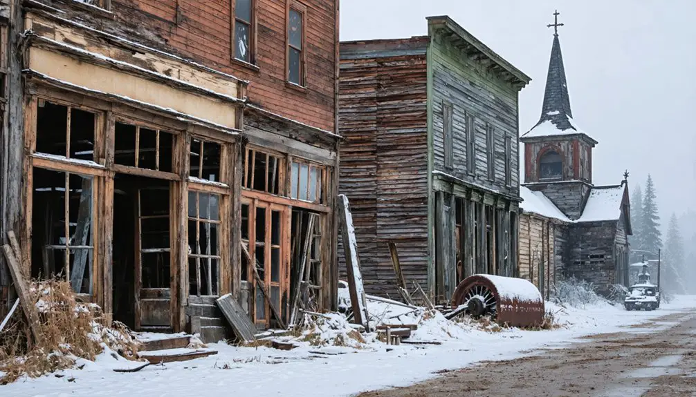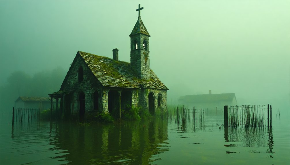
West Virginia’s Summersville Lake conceals entire ghost towns beneath its remarkably clear waters, most conspicuously Gad—an 1889 settlement established along McKee’s Creek that now rests 390 feet below the dam’s crest. When the U.S. Army Corps of Engineers completed the flood control project in 1966, they submerged multiple communities including Sparks, displacing residents and relocating six cemeteries from Gad alone. Today’s divers document foundations, roads, and artifacts during seasonal drawdowns, while the lake’s exceptional visibility reveals structural remnants that underwater archaeologists continue to catalog and preserve.
Key Takeaways
- Gad, established 1889, and Sparks, established 1907, are submerged communities beneath Summersville Lake, called “Appalachian Atlantis.”
- Communities were displaced under the 1938 Flood Control Act; entire towns including cemeteries were relocated before submersion in the 1960s.
- Summersville Dam, completed 1966, created West Virginia’s largest lake covering 2,700 acres over former settlements and cultural sites.
- Seasonal water drawdowns expose foundations, roads, and artifacts, enabling underwater archaeologists and divers to document submerged remnants.
- Clear reservoir waters exceeding 20 feet visibility allow detailed exploration of structures, with hundreds of divers visiting these underwater ghost towns.
The Vanished Community of Gad, Nicholas County
Established in 1889 along McKee’s Creek in Nicholas County, Gad derived its name from the surname Gadd, spelled with two Ds.
This farming community sustained itself through the 1960s, maintaining a sawmill, church, school, general store, and post office.
The U.S. Army Corps of Engineers purchased the properties in the 1960s, forcibly relocating residents to construct Summersville Lake’s dam, completed in 1966.
Six family graveyards were relocated during clearance.
Today, the town’s remnants rest intact beneath the reservoir’s clear waters, forming what divers call the “Appalachian Atlantis.”
Summersville Lake has earned the nickname “The Little Bahamas of the East” for its warm, clear waters.
Scuba explorers document preserved structures, including clapboard houses, fences, and vintage automobiles.
The Reese family made the initial discovery while diving in the lake’s exceptionally clear waters.
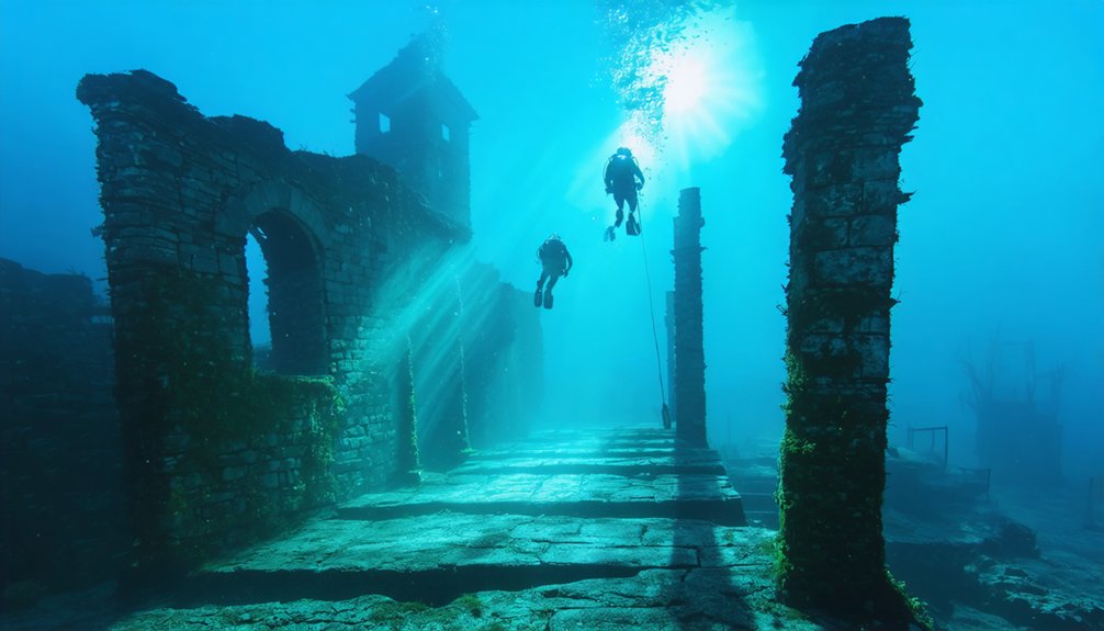
This site serves as an underwater archaeology destination where historians conduct methodical documentation.
Local legends persist about the “Maids of Gad,” maintaining their submerged homes with fresh curtains.
Building Summersville Lake: Engineering Flood Control
The U.S. Army Corps of Engineers initiated Summersville Dam construction in 1960.
They completed the 390-foot-high, 2,280-foot-long rock-fill structure in 1966 at a cost of $48 million.
You’ll find this dam manages an 803-square-mile watershed to control flooding across five West Virginia counties in the Kanawha Valley.
Engineers incorporated a 29-foot-diameter outlet tunnel as the primary release mechanism, allowing precise water discharge regulation downstream.
The hydroelectric facility, completed in 2001, generates 80 megawatts of electricity for the region.
The dam sits on the Gauley River in Nicholas County, creating West Virginia’s largest lake with nearly 2,800 surface acres.
Dam Construction Timeline
Authorized under Section 4 of the Flood Control Act of 1938, Summersville Dam commenced construction in February 1960 under United States Army Corps of Engineers supervision.
You’ll find the industrial archaeology of this project reveals systematic displacement — Gad’s farming community relocated before construction began.
The rolled-earthfill design demonstrated engineering precision:
- 1960-1965: Dam construction progressed using 12,000,000 cubic yards of dirt and rock
- 1965: Topping out completed at 390 feet height, 2,280 feet length
- 1966: Full construction finished; President Johnson dedicated the facility September 3
- 1996-2001: Hydroelectric development added 80 MW capacity via two Francis turbines
The ecological impact transformed 803 square miles of watershed into a 2,700-acre reservoir with a 327-foot maximum depth — creating flood control at considerable environmental cost. The dam maintains a minimum flow of 100 cubic feet per second downstream to support ecological requirements. The structure stands as the second-largest rock-fill dam in the Eastern United States, a testament to mid-century engineering ambition.
Flood Control Purpose
Beyond its dramatic transformation of West Virginia’s landscape, Summersville Dam functions as a critical component in the Ohio River Basin’s flood control infrastructure. You’re looking at a system that controls 803 square miles of drainage area, managing the historically volatile Gauley River that once threatened agricultural history and Indigenous settlements downstream.
The Corps operates this 390-foot rock-fill barrier through seasonal elevation changes—raising waters to 1,652 feet for summer recreation, then lowering to 1,575 feet for maximum flood storage capacity. This methodical approach has prevented $345 million in flood damage since 1966, protecting Nicholas County and the Kanawha River valley.
The project’s $48 million construction cost paid for itself multiple times over, demonstrating how engineering intervention preserves both property and regional autonomy. The 2,790-acre reservoir created by the dam serves multiple purposes beyond flood control, including flow augmentation and recreation. Water release is controlled through a tunnel with three 9-ft valves, which then flows through a hydropower plant built in 2001.
Engineering the Diversion Tunnel
Before engineers could raise a 390-foot barrier across the Gauley River, they confronted an elemental challenge: you can’t build a dam’s foundation while millions of gallons surge through the construction site.
The solution required audacious intervention—literally moving a mountain to redirect nature’s flow.
Starting in spring 1962, crews executed a precise sequence:
- Tunnel excavation – Teams bored simultaneously from opposite mountain flanks, meeting mid-ridge to install steel reinforcement.
- River diversion – Temporary cofferdam redirected flow through the completed tunnel.
- Foundation preparation – Workers removed 2,000 feet of sediment to bedrock for sedimentation management.
- Core installation – Clay trench created the impervious barrier essential for hydroelectric power generation.
This methodical approach transformed uncontrollable water into controlled resource, enabling foundation work that would ultimately displace entire communities. The tunnel’s circular design would eventually split into three separate conduits, each equipped with specialized valves for precise flow control. The 29-foot outlet tunnel would later serve as the primary water conveyance system when hydroelectric facilities were added to the dam in 2001.
Other Lost Communities Beneath West Virginia Reservoirs
Beyond Gad’s submerged remnants, you’ll find Sparks community resting beneath the same Summersville Lake waters after its 1966 inundation.
Established in 1907 and named for Joseph Sparks, this farming settlement left minimal documentation compared to its neighbor. The Stiltner and East Lynn communities met similar fates under different West Virginia reservoirs.
Though surviving records provide limited details about their pre-flooding populations and infrastructure.
Sparks Community Under Water
Approximately sixty years after its establishment, the Sparks farming community disappeared beneath Summersville Lake’s waters when the U.S. Army Corps of Engineers acquired all properties under the Flood Control Act of 1938.
Named after Joseph Sparks in 1907, this settlement met the same fate as neighboring Gad during the 1960s dam construction.
Technical specifications of the submersion:
- Reservoir depth reaches 327 feet at maximum capacity
- Nearly 3,000 acres now cover former community lands
- Drainage occurs every 10 years, exposing original roads and foundations
- Water clarity exceeds 20 feet visibility for documentation
Local legends persist among displaced families, though ecological impacts created West Virginia’s clearest freshwater reservoir.
You’ll find minimal historical records compared to Gad, yet underwater remnants verify the community’s existence through foundation structures accessible during maintenance drawdowns.
Stiltner and East Lynn
The U.S. Army Corps of Engineers permanently submerged Stiltner in 1969 beneath East Lynn Lake‘s waters. You’ll find this unincorporated Wayne County community at coordinates 38°07′55″N 82°22′50″W, where Brush Creek once met Twelvepole Creek.
The Stiltner family’s namesake settlement operated a post office before flood control operations drowned it. Underwater archaeology reveals infrastructure remnants inaccessible to surface investigation.
East Lynn Lake’s construction displaced residents who’d established rural homesteads in this tributary valley. The impoundment exemplifies government reservoir projects that eliminated communities without consent.
Reservoir ecology now dominates where families once lived freely. You can’t visit Stiltner’s submerged remains—they’re locked beneath the lake’s surface.
This ghost town joins West Virginia’s catalog of settlements sacrificed for centralized water management systems that prioritized flood control over individual property rights.
As a result, similar underwater ghost towns in Ohio serve as reminders of the often unseen impact of infrastructure development on local communities. These submerged sites tell stories of families displaced and histories lost beneath the water’s surface. Exploring these areas reveals a haunting beauty and a complex relationship between progress and preservation.
Diving the Appalachian Atlantis: What Lies Below
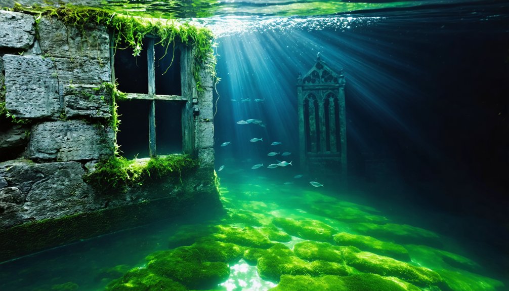
Beneath Summersville Lake’s surface lies what divers call the “Appalachian Atlantis”—the submerged remains of Gad, a town that disappeared when the US Army Corps of Engineers completed the rock-fill dam in 1966.
Located near the marina at coordinates 38°14′23″N 80°53′3″W, the site offers unrestricted exploration through West Virginia’s clearest waters.
Documentation reveals varying conditions:
- Structural remnants: Foundations, road traces, and scattered artifacts persist after decades underwater.
- Visibility factors: Notoriously clear water enables detailed examination of underwater flora and aquatic fauna colonizing historic structures.
- Seasonal access: Winter drawdowns occasionally expose roads, foundations, and personal items like marbles.
- Dive positioning: Proximity to Summersville Marina provides convenient entry points for independent exploration.
Contrasting reports exist—some sources claim intact houses while others document only foundational scraps.
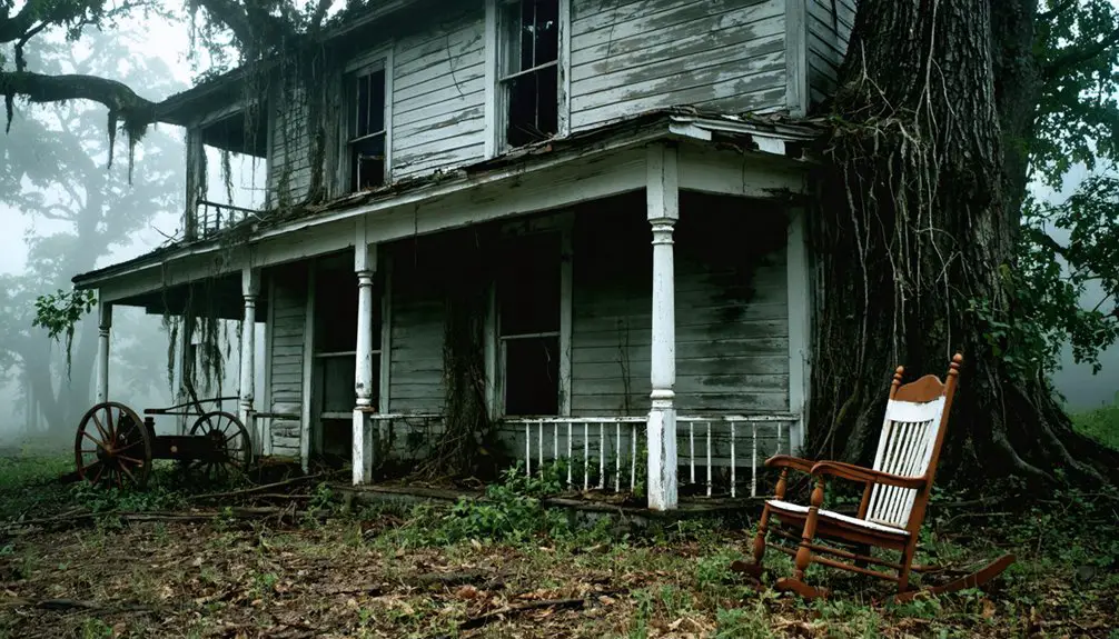
The Human Cost of Relocation
When federal authorities initiated property acquisitions in the 1960s, the U.S. Army Corps of Engineers systematically dismantled Gad and surrounding communities for Summersville Lake construction.
You’ll find documented cases where residents were forced from generational farming lands between 1960 and 1966, their property rights subordinated to flood control objectives.
The emotional trauma proved devastating—elderly farmers never recovered from displacement shock, while families witnessed their ancestral burial sites become inaccessible underwater graves.
Hugh Lord’s defiant act of burning his home before departing by boat exemplifies the psychological toll.
While authorities cite economic impact benefits of $407,400,000 in prevented flood damages, relocated populations paid immeasurable costs.
Six family cemeteries required relocation, entire communities scattered, and residents described feeling “run like ducks somewhere”—their autonomy sacrificed for centralized development priorities.
Recreation on Sacred Ground: Summersville Lake Today
Since 1966, Summersville Lake has transformed the submerged remains of Gad and surrounding settlements into West Virginia’s premier recreational destination. It spans 2,800 acres with 60 miles of shoreline along the impounded Gauley River.
Nearly one million annual visitors now explore waters concealing folklore legends and potential archaeological discoveries beneath limestone-filtered depths.
Current recreational infrastructure includes:
- Water sports operations: kayaking, paddleboarding, jet-skiing, and cliff diving from Nuttall sandstone formations
- Technical climbing access: 1,000+ routes on exposed cliffs surrounding the reservoir
- Controlled whitewater releases: six weekends annually (September-October) generating world-class Gauley River rafting
- Land-based facilities: 177-acre state park, hiking trails, and mountain biking networks
This recreational overlay exists directly above former community sites, creating tension between heritage preservation and public access to these transformed landscapes.
Preserving the Memory of Submerged Appalachia
Despite Summersville Lake’s economic benefits—$407.4 million in prevented flood damages since 1966—the deliberate inundation of Gad and neighboring settlements represents an irreversible erasure of Appalachian cultural landscapes that agencies now struggle to document.
The $407.4 million in flood prevention came at an incalculable cost: entire Appalachian communities erased beneath engineered waters.
You’ll find preservation efforts fragmented across unofficial channels. Divers photograph submerged structures and standing forests, while winter drainings expose roadways, foundations, and stone carvings for temporary documentation.
Online repositories archive these remnants, though degradation accelerates with each flooding cycle. Ancient artifacts from six relocated cemeteries received formal reburial, yet countless unmarked sites remain underwater.
Ecological impacts compounded cultural losses—native flora vanished beneath engineered reservoirs. No government database catalogs Gad’s oral histories or architectural records.
Wikipedia entries and YouTube testimonials preserve what federal authorities dismissed: communities sacrificed without exhaustive historical accounting.
Frequently Asked Questions
Are There Any Artifacts or Personal Belongings Still Recoverable From Underwater Gad?
You’ll find artifact preservation conditions favorable in Summersville Lake’s clear waters, though no extensive underwater archaeology inventory exists. Divers continue documenting remnants, but recovery depends on legal permissions and your commitment to proper archaeological protocols and documentation standards.
How Deep Is Summersville Lake Where the Town of Gad Once Stood?
Buried beneath time’s watery veil, Gad rests where water depth measurements aren’t precisely documented for that specific location. You’ll find lake sedimentation has likely obscured exact depths, though surrounding areas reach 100-327 feet depending on topography.
Do Descendants of Relocated Families Ever Dive to See Their Ancestral Homes?
Yes, you’ll find documented cases where descendants have dived to ancestral Gad sites. A 2016 report confirms one family scuba-dived and photographed their submerged homestead, preserving family memories and heritage through underwater documentation of their generational farmland.
Were Any Structures Intentionally Preserved or Documented Before the Lake Filled?
Documentation efforts remain unclear, though you’ll find most lakeside architecture was demolished rather than preserved. Historical preservation wasn’t Duke Energy’s priority—only property disputes saved structures like Attakulla Lodge. Verification of photographic evidence stays incomplete.
What Happened to the Livestock and Farm Equipment During Relocation?
You’ll find no direct records documenting livestock displacement or farm equipment salvage methods. However, evidence suggests families relocated animals themselves before flooding, while equipment was likely sold or transported, maintaining your ancestors’ autonomous property rights during forced relocation.
References
- https://www.thewanderingappalachian.com/post/underwater-ghost-towns-of-appalachia
- https://www.onlyinyourstate.com/trip-ideas/west-virginia/gad-wv
- https://www.blueridgeoutdoors.com/go-outside/sunken-secrets-the-underwater-ghost-towns-of-the-blue-ridge/
- https://www.thewanderingappalachian.com/post/the-underwater-towns-of-appalachia
- https://www.youtube.com/watch?v=IABhuspHxuU
- https://en.wikipedia.org/wiki/List_of_ghost_towns_in_West_Virginia
- https://visitwv.com/the-atlantis-of-appalachia/
- https://wvtourism.com/summersville-gad-dam/
- https://aceraft.com/new-river-gorge/summersville-lake/summersville-dam/
- https://wvpublic.org/september-3-1966-summersville-lake-and-dam-dedicated/