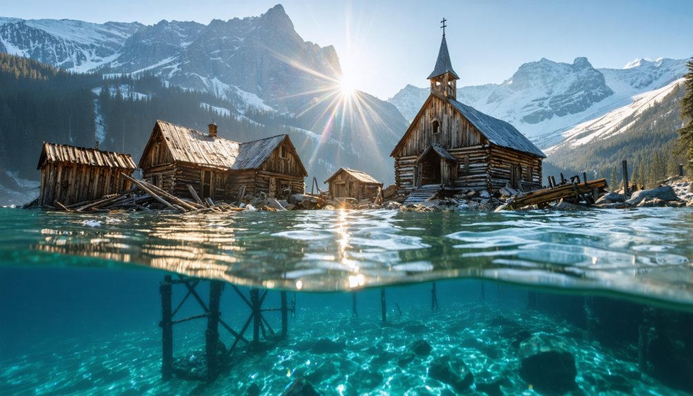
You’ll find several submerged settlements in Rocky Mountain reservoirs, including Alberta’s Minnewanka Landing (flooded 1941) and Colorado’s Montgomery (submerged 1957). These sites resulted from hydroelectric dam construction between the 1890s-1960s, which systematically flooded entire communities. Cold, glacier-fed waters (approximately 2°C) create anoxic conditions that inhibit bacterial decomposition, preserving timber structures and foundations at depths reaching 18-60 feet. Seasonal drawdowns periodically expose archaeological features including hotel foundations, cemeteries, and infrastructure remnants. The outlined sections below detail specific sites, preservation mechanisms, and exploration protocols.
Key Takeaways
- Lake Minnewanka in Alberta contains a submerged village flooded in 1941, with preserved timber foundations visible at 18-meter depths in glacier-fed waters.
- Montgomery, Colorado was completely flooded in 1957 after dam construction, leaving only Montgomery Mill above water while structures rest underwater.
- Stout, a sandstone quarrying town, was submerged in 1946 during Colorado-Big Thompson Project reservoir filling, with foundations visible during drawdowns.
- Dillon, Colorado was relocated multiple times before final submersion in 1963 to create a reservoir for water supply infrastructure needs.
- Cold glacier-fed waters preserve underwater structures exceptionally well, allowing scuba divers to explore intact foundations and archaeological artifacts.
Minnewanka Landing: Alberta’s Submerged Summer Village
What transforms a thriving resort village into an underwater archaeological site? You’ll find the answer at Minnewanka Landing, where three successive dams between 1895 and 1941 progressively submerged Alberta’s premier summer destination.
The final wartime embankment raised water levels 30 meters, completely flooding the settlement under the War Measures Act. Today, glacier-fed waters preserve this submerged architecture with remarkable integrity—you can observe intact wood grain on century-old timbers at 18-meter depths.
The lake ecology supports exceptional preservation conditions, maintaining foundations, wharves, and 1912 dam technology as Canada’s most intact underwater village. Eight thousand advanced divers annually explore these sites, where sidewalks, bridge pilings, and hotel remnants emerge suddenly from low-visibility conditions. The submerged town once featured four avenues and three streets that formed the organized layout of this bustling summer community.
This involuntary resettlement created an unintended archaeological treasure within Canada’s national park system. Before the flooding, Minnewanka Landing thrived as a lively resort town during the 1890s.
Montgomery Reservoir: Colorado’s Drowned Mining Settlement
When prospectors discovered placer gold deposits in the Platte River valley in 1861, they established Montgomery six miles north of Alma at Mount Lincoln’s base—creating one of Park County’s earliest settlements after Buckskin Joe.
Founded in 1861 following a gold strike, Montgomery became one of Park County’s first settlements alongside Buckskin Joe.
The town’s nine mines along the Kansas-Magnolia vein supported over 1,000 residents across 150 cabins, hotels, and taverns. The settlement’s popular dancehall drew miners from surrounding camps, while successive mineral discovery waves fueled expansion of hospitality businesses and family formation.
After ore depletion triggered abandonment, Colorado Springs acquired the land for water conservation purposes. Montgomery Dam’s 1957 completion submerged the entire settlement beneath what’s now Montgomery Reservoir.
You’ll find the Magnolia Mill standing as the sole above-water remnant, while most structures rest at the reservoir bottom—creating an underwater archaeology site accessible only through documentation. The original five sawmills that once operated in Montgomery have been reduced to this single visible structure.
The reservoir’s crystal-clear waters attract anglers pursuing rainbow trout above Colorado’s drowned mining heritage.
Horsetooth Reservoir: Fort Collins’ Hidden Historical Townsite
While sandstone quarrying operations dominated the economic landscape near Fort Collins during the 1870s, the settlement of Stout emerged in 1873 as Colorado’s premier source of high-grade building stone. You’ll find its legacy embedded in historical architecture from the Colorado State Capitol to Chicago’s 1893 World’s Fair structures.
The town peaked during the 1880s-1890s, housing hundreds of workers serviced by Colorado and Southern Railroad terminals. Fort Collins’ prohibition laws created an unexpected economic boost, as Stout became an alcohol purchasing haven for residents seeking spirits outside city boundaries.
The Bureau of Reclamation sealed Stout’s fate in 1946, acquiring properties for the Colorado-Big Thompson Project. By January 1951, groundwater influence transformed the valley into Horsetooth Reservoir’s south basin. The reservoir’s filling submerged the entire town, leaving only remnants beneath the water.
You can explore submerged foundations during low-water periods, with visible sandstone deposits flanking today’s reservoir. The former boarding house remains visible above waterline—testament to this vanished quarrying community.
Dillon Reservoir: A Relocated Community Beneath the Waters
Unlike Stout’s singular relocation beneath reservoir waters, Dillon underwent three documented migrations before its final submersion in 1963. You’ll find this community’s history reflects calculated displacement: founded 1881, first relocated for railroad access, then moved again in 1892 to capture consolidated rail traffic.
Denver Water Board’s early 1900s surveys initiated systematic property acquisition, accelerated through Depression-era tax foreclosures. By 1961, over 800 residents—Summit County’s largest population—faced forced sales.
Urban archaeology reveals minimal infrastructure remains: only road traces and foundations survived flooding. The environmental impact extended beyond structures; 300+ cemetery graves required court-ordered exhumation in 1962.
Ten homes physically relocated, though demolition claimed most buildings. Remaining buildings were either moved or abandoned before the reservoir waters rose. This engineered submersion prioritized South Platte water supply over established settlement patterns. The reservoir’s construction included the Harold D Roberts Tunnel, which diverted water resources essential to Colorado’s water infrastructure.
Preservation and Visibility: When Ghost Towns Resurface
When reservoir water levels drop during drought conditions or seasonal drawdowns, you’ll observe previously submerged structures emerging from depths exceeding 30 meters.
The glacier-fed, 2°C waters of these Rocky Mountain reservoirs substantially decelerate bacterial decomposition and inhibit wood-consuming organisms, preserving timber foundations, wharves, and architectural elements for decades.
You can document this preservation phenomenon at sites like Horsetooth Reservoir, where receding waters periodically expose intact hotel towers.
And Lake Minnewanka, where stone foundations and indigenous artifacts spanning 13,000 years maintain structural integrity without significant biological degradation. The 1941 dam construction raised the lake by 30 meters, creating the submerged landscape that divers explore today.
Low Water Level Reveals
Prolonged drought conditions and strategic water releases transform submerged ghost towns from inaccessible archaeological sites into visible historical landscapes. You’ll observe this phenomenon across Rocky Mountain reservoirs where water levels dropped drastically in 2021.
Among these sites are the underwater ghost towns in Montana, which reveal the remnants of once-thriving communities that adapted to a different way of life. As the waters recede, visitors can wander through the remains of buildings and streets, gaining insight into the area’s history and the effects of environmental change. This rare opportunity to explore the past is not only captivating for history enthusiasts but also serves as a poignant reminder of the ongoing challenges posed by climate change.
Navajo Reservoir near Pagosa Springs fell 70 feet below full pool, exposing railroad grades and town foundations at Arbolese Point. Blue Mesa Reservoir between Gunnison and Montrose experienced similar drops due to emergency releases preventing Lake Powell’s collapse.
Horsetooth Reservoir’s low water revealed Stout’s hotel tower at the south end. These environmental consequences enable unrestricted pedestrian access to previously submerged structures.
Montgomery Reservoir’s exposed sawmill remnant documents 1861 silver mining operations. During drawdowns, foundations and graves occasionally surface and can be viewed by boat, similar to documented occurrences at other reservoirs.
The cultural impacts include unprecedented opportunities for surface-level archaeological documentation without diving equipment, though regional over-usage accelerates reservoir depletion.
Structural Preservation in Cold Water
Glacier-fed waters averaging 2°C create ideal preservation conditions that maintain organic materials in Rocky Mountain reservoirs for decades beyond typical underwater degradation timelines.
You’ll find wooden structures retain visible grain details, with foundations, wharves, and infrastructure resisting bacterial decomposition that normally destroys submerged timber. Mineral-rich glacier water inhibits organic decay processes, allowing Lake Minnewanka’s 1895 federal dam footings and hotel foundations to remain identifiable.
Digital mapping technologies enable 8,000 annual divers to document these sites with unprecedented accuracy when seasonal clarity permits detailed observation. The cultural significance extends beyond colonial structures—indigenous campsites and artifacts coexist with twentieth-century infrastructure.
Cold water clarity facilitates archaeological documentation efforts, though natural flooding events periodically challenge visibility parameters essential for extensive structural assessment and photographic evidence collection.
Exploring Submerged Communities: Access and Recreation
You can access Rocky Mountain submerged settlements through scuba excursions at Lake Minnewanka, where Parks Canada documents the most intact underwater village in Canada at depths reaching 60 feet.
Seasonal reservoir drawdowns at sites like Horsetooth Reservoir expose structural remnants including hotel towers and foundations when water levels drop below normal operating ranges.
Legal entry requires permits from managing authorities, while cold glacier-fed waters demand technical certification and thermal protection equipment for safe exploration.
Diving and Boat Tours
While most ghost towns require terrestrial hiking, submerged communities demand specialized aquatic access methods that reveal preserved architectural remnants beneath reservoir surfaces.
You’ll access Lake Minnewanka’s 1941-flooded resort through scuba diving, where glacier-fed waters preserve house foundations, wharves, and bridge pilings for underwater archaeology documentation.
Technical dives at Jocassee Lake reach 300-foot depths to examine Attakulla Lodge and Mount Carmel Cemetery’s readable tombstones, enabling historical reconstruction of pre-dam settlements.
Fontana Lake offers pontoon and houseboat rentals for surface observation during drawdown periods when Judson’s foundations emerge.
You’ll require dive shop guides for deep-site navigation and land-access permissions for drawdown exploration.
Horsetooth Reservoir’s southern end exposes hotel tower remnants at low water levels.
Montgomery Reservoir’s 150 submerged structures remain inaccessible without authorized programs.
Seasonal Water Level Changes
Reservoir drawdown cycles create temporal windows for terrestrial access to submerged archaeological sites, with hydrological variations governed by drought patterns, irrigation demands, and dam operations.
You’ll find Cultural Impact manifestations when water levels drop dramatically—Iola’s general store and flagpole emerged at 40% capacity, while Navajo Reservoir’s 70-foot decline exposed previously hidden structures.
Environmental Effects include altered water tables transforming former cemeteries into wetlands, as documented at Olive hamlet’s burial grounds beneath Ashokan Reservoir.
Access opportunities during drawdown include:
- Terrestrial exploration of Judson’s foundations and graves at Fontana Lake’s lowest levels
- Pontoon boat reconnaissance over submerged ruins during intermediate water clarity periods
- Archaeological documentation within reservoir take lines during extended drought cycles
- Cemetery site observation along exposed shorelines at multiple Rocky Mountain reservoirs
Safety and Legal Considerations
Before accessing submerged ghost towns in Rocky Mountain reservoirs, you must navigate complex regulatory frameworks that intersect federal recreation area mandates, provincial heritage protections, and municipal water authority jurisdictions.
Lake Mead National Recreation Area requires entrance fees and boundary-specific permits for St. Thomas access.
Parks Canada designates Lake Minnewanka’s underwater structures as protected cultural heritage sites with archaeological management oversight.
Fontana Lake demands special authorization before drawdown-period viewing of Judson’s remains.
Scuba certification and cold-water equipment are mandatory for Lake Minnewanka’s glacier-fed waters, where recent floods severely reduce visibility.
Advanced diver experience levels become critical given these challenging conditions.
Wildlife interactions require additional precautions in these protected ecosystems.
Water management authorities control reservoir levels, directly affecting both accessibility and structural preservation at sites like Dillon and Montgomery, where original townsites remain submerged under regulated protection.
The Legacy of Hydroelectric Development in the Rockies
The transformation of the Rocky Mountain region through hydroelectric development fundamentally altered western water policy and economic geography throughout the twentieth century. Dam construction reshaped hydroelectric ecology across multiple watersheds, from Roosevelt Dam‘s 1911 completion through Glen Canyon’s controversial mid-1960s creation.
You’ll find this infrastructure enabled unprecedented regional transformation:
- Agricultural electrification: Salt River Project achieved 100% farm electrification by 1929, powering 7,000 operations.
- Industrial expansion: Copper mining and Phoenix metropolitan growth depended on Roosevelt Dam’s reliable electricity.
- Interstate water compacts: The 1922 Colorado River Compact facilitated federal investment, fundamentally restructuring western water rights.
- Multi-state power distribution: Hoover Dam supplies millions across California, Nevada, and Arizona.
These projects prioritized economic development over preservation, creating the submerged ghost towns you’re exploring today.
Many of these remnants, like those found in ghost towns in the Great Plains, serve as haunting reminders of a bygone era. As you wander through these areas, you can visualize the lives that once thrived there. Each structure tells a story of resilience and change, reflecting the economic tides that have shaped this region.
Frequently Asked Questions
Are There Any Safety Concerns When Diving Near Submerged Ghost Towns?
You’ll face significant diving safety risks including hypothermia in glacier-fed waters, structural collapse from deteriorated foundations, entanglement hazards, and decompression challenges at extreme depths. Historical preservation regulations also restrict access, requiring permits and guided dives for compliance.
How Do Extreme Weather Patterns Affect Underwater Ghost Town Visibility?
While you’d expect consistent conditions, climate change drives erratic water levels and sedimentation that’ll dramatically alter your visibility. Extreme floods suspend sediments reducing clarity to under 20 feet, while droughts expose sites but increase turbidity through runoff.
What Artifacts Have Been Recovered From Rocky Mountain Submerged Towns?
You’ll find ancient artifacts including Clovis spearpoints over 10,000 years old, prehistoric skulls, blacksmith tools, and preserved structures like hotel sites, concrete steps, and 1912 dam technology recovered from Rocky Mountain submerged settlements through systematic archaeological documentation.
Can Underwater Photography Capture the Preserved Structures in These Ghost Towns?
Yes, you’ll capture preserved structures effectively. Technical divers document artifacts at 300-foot depths using specialized camera equipment. Underwater reflections don’t notably impair imaging—cold Rocky Mountain waters maintain visibility ranges of 20-30 feet for photographing intact foundations and architectural remnants.
Were Residents Compensated When Their Towns Were Flooded for Reservoirs?
Yes, residents received compensation, though economic impacts varied considerably. You’ll find Dillon’s early property acquisitions and Depression-era tax sales demonstrate relocation challenges. Documentation shows Bureau of Reclamation purchased rights, but individual settlement terms weren’t uniformly equitable across projects.
References
- https://www.smithsonianmag.com/travel/underneath-canadian-lake-sits-preserved-ghost-town-180964645/
- https://www.blueridgeoutdoors.com/go-outside/sunken-secrets-the-underwater-ghost-towns-of-the-blue-ridge/
- https://avltoday.6amcity.com/remembering-judson-wncs-underwater-ghost-town
- https://www.youtube.com/watch?v=svK6rZjY7A8
- https://www.onlyinyourstate.com/trip-ideas/colorado/underwater-colorado-ghost-town
- https://collegeavemag.com/246811/features/horsetooth-reservoir-the-underwater-history-of-a-long-lost-ghost-town/
- https://en.wikipedia.org/wiki/List_of_ghost_towns_in_Colorado
- https://kekbfm.com/colorado-old-dillon-ghost-town/
- https://bmoreenergy.wordpress.com/2022/08/10/top-ten-cool-facts-about-lake-dillon-co-an-underwater-ghost-town/
- https://globalnews.ca/news/9172928/alberta-lake-minnewanka-indigenous-history/


