
You’ll find several submerged communities beneath West Coast reservoirs, revealed only when drought lowers water levels. Kennett lies 400 feet below Shasta Lake since 1944, while Whiskey Flats and Old Kernville remain under Lake Isabella from 1954 flooding. Millerton disappeared beneath Friant Dam in 1939, and St. Thomas emerges periodically from Lake Mead after its 1935 submersion. These sites preserve gold rush infrastructure, pioneer foundations, and indigenous heritage—tangible records of displacement through dam construction. Understanding their locations, histories, and accessibility patterns requires examining each settlement’s unique circumstances.
Key Takeaways
- Kennett, California, thrived for 60 years before submersion beneath Shasta Lake in 1944, displacing residents without public hearings.
- Whiskey Flats became underwater in 1954 beneath Lake Isabella; foundations emerge during droughts at California Historical Landmark #132.
- Old Kernville was condemned in the 1940s, with 500 residents relocated before flooding in 1954 under Isabella Dam.
- Millerton submerged after 1939 under Friant Dam, once serving as the Fresno-Madera boundary with extensive gold excavations.
- St. Thomas, Nevada, founded in 1865, lies beneath Lake Mead since 1935, revealing pioneer foundations during drought periods.
Kennett: The Drowned Railroad Town of Shasta Lake
In 1944, the waters of Shasta Lake rose to submerge Kennett under 400 feet of water, erasing a railroad town that had thrived for six decades in Northern California’s Shasta County. You’ll find no trace of the 40 saloons, opera house, or bustling mining infrastructure that once defined this settlement.
Hydroelectric dams promised regional progress, but residents received no public hearings before displacement. The Mammoth Mine had already closed in 1923 following pollution lawsuits, leaving the community vulnerable when federal dam plans materialized. The town had boomed during WWI when rising copper prices drove expansion of mines, smelters, and railways throughout the district.
Water level fluctuations now reveal scattered foundations where 6,000 acres of private property once stood. Before the mines arrived, 250 Wintu villages had dotted the Kennett area until disease and war decimated the indigenous population by 1835. Construction began in 1935, systematically flooding Kennett alongside Copper City, Elmore, and Pitt—erasing communities without meaningful consent from those who’d built them.
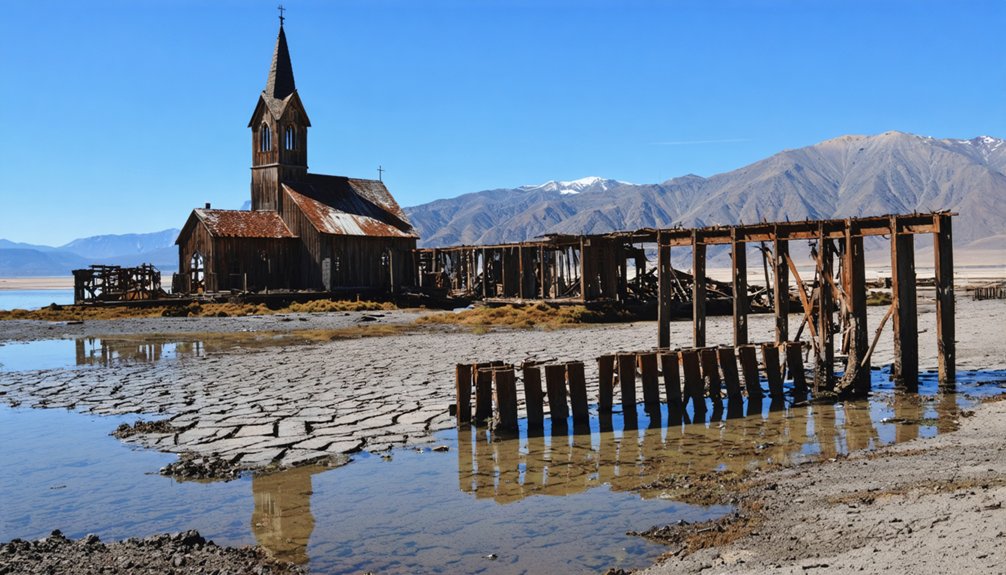
Whiskey Flats: Gold Rush Memories Beneath Lake Isabella
When gold-seeker Lovely Rogers struck ore at the Big Blue Mine in 1858, he triggered a rush that would transform a remote Kern River canyon into one of California’s most notorious mining settlements.
One prospector’s 1858 discovery at Big Blue Mine sparked the gold rush that birthed a legendary Kern River boomtown.
Adam Hamilton established what locals called Whiskey Flat in 1860, where his saloon served both liquor and Sunday worship.
You’ll find this site’s mining heritage documented at California Historical Landmark #132, now submerged beneath Lake Isabella since the 1954 Kern River damming.
The reservoir’s fluctuating levels periodically expose foundations of the schoolhouse, general store, jail, and Methodist church.
During September 2022’s drought, when capacity dropped to 8%, you could witness these River legends reemerge.
The town gained additional fame as a filming location for Hollywood westerns including “Stagecoach” and “Treasure of Sierra Madre.”
Resident Newt Walker famously demonstrated his gun-drawing skills in a 1905 courtroom appearance, exemplifying the settlement’s Wild West character.
The Kern River Valley Historical Society preserves this history through annual Whiskey Flat Days reenactments each February.
Old Kernville: A Relocated Community’s Flooded Past
Three miles upstream from Whiskey Flat, the settlement of Rogersville emerged in 1858 after Lovely Rogers discovered gold while pursuing his escaped mule near the Big Blue Mine.
You’ll find this community evolved through several identities—Rogersburg, Williamsburg, Whiskey Flat, and finally Kernville in 1864—before federal authorities condemned it in the late 1940s for Isabella Dam construction.
Despite residents’ resistance to government acquisition, approximately 500 people relocated before the 1953-1954 flooding.
Officials dynamited the schoolhouse, general store, jail, and 1898 Methodist church rather than preserve them.
Today, you can observe building foundations when drought lowers reservoir levels, though clearing sediment reveals how little effort went into preserving artifacts.
The area once served as a peaceful settlement for the Tubatulabal and Kawaiisu tribes before conflicts erupted.
The Isabella Dam and Reservoir, completed in 1950 under the 1944 Flood Control Act, transformed this valley into a permanent water storage facility.
California Historical Landmark #132 now marks where your freedom to stay was overridden by irrigation and flood control objectives.
Millerton: The Vanished Settlement of Friant Dam
The Central Valley Project‘s Friant Dam construction between 1937 and 1942 eliminated Millerton, the former county seat situated on the San Joaquin River at the boundary of Fresno and Madera Counties.
You’ll find this settlement, once 15 miles north of Fresno, now rests beneath 520,500 acre-feet of water.
The dam’s excavation work uncovered 5,400 ounces of placer gold and ancient artifacts, including Native American burial sites that were relocated during construction.
Hydroelectric projects like this transformed California’s agricultural capacity—the resulting Madera and Friant-Kern Canals irrigated millions of acres across four counties.
When Millerton Lake’s water levels drop, you can spot the SS Relief floating restroom, a rare visible remnant of the community forced to relocate before 1942’s final flooding.
The 1939 groundbreaking ceremony drew over 50,000 attendees, marking one of the valley’s largest celebrations as the region witnessed the beginning of its massive transformation.
The submerged town stands as a testament to water infrastructure’s cultural impacts, representing how California’s dam projects reshaped not only landscapes but entire communities throughout the state’s water-rich regions.
St. Thomas: Nevada’s Mormon Town Rising From Lake Mead
Forty miles northeast of Las Vegas, St. Thomas emerges from Lake Mead‘s receding waters, revealing a Mormon settlement founded in 1865.
You’ll find concrete-lined irrigation canals, house foundations, and a 60-foot chimney marking what was once a thriving agricultural community.
When Hoover Dam‘s construction demanded the land in 1928, the government seized it through eminent domain, forcing evacuation by 1932.
Lake Mead’s waters submerged the town over 60 feet deep in 1935.
Today’s drought exposes ancient artifacts and indigenous traces alongside remnants from explorers, miners, and LDS pioneers.
The exposed ground reveals sedimentary rock layers formed over millions of years from ancient seas that once covered this region.
Archaeologists catalog discoveries while preserving most in situ.
The lake’s fluctuating levels have allowed for reunions at the site, with former residents gathering in 1945, 1965, and 2012 to reminisce about their lost community.
You can access the site via northern Lake Mead’s trailhead, where dropping water levels continuously reveal new evidence of Western settlement patterns and displacement history.
Bombay Beach and the Accidental Salton Sea
When the Colorado River breached an irrigation canal in spring 1905, it flooded the Salton Sink for eighteen months and created California’s largest inland sea.
You’ll find Bombay Beach, established in 1929, once thrived as a water recreation haven where Frank Sinatra visited and property values soared through the 1960s.
The environmental impact began when agricultural runoff increased salinity levels by the 1970s.
Hurricane Kathleen’s 1976 flooding—raising sea levels eight feet in three hours—destroyed structures beyond protective berms.
Fish populations collapsed by the 1980s, triggering massive die-offs and avian botulism outbreaks.
Today, you’re exploring a ghost town where only invasive tilapia survive in toxic waters.
The ecosystem’s collapse drove residents away, leaving abandoned marinas and shuttered businesses as evidence of unchecked environmental degradation.
When Droughts Reveal Hidden History: Visiting Submerged Towns
While Bombay Beach’s toxic waters emerged from human intervention and climate catastrophe, Western droughts operate differently—they temporarily reverse decades-old flooding to expose submerged communities.
You’ll find underwater archaeology opportunities at St. Thomas, Nevada, where Lake Mead’s receding waters reveal Mormon pioneer foundations from 1865 and ancient Pueblo Grande de Nevada villages dating to AD 300.
Exploring the remnants of past communities can lead to unexpected discoveries, much like the ghost towns in the Pacific Northwest that tell stories of a different era. These abandoned sites, enveloped by nature, offer a glimpse into the lives of those who once thrived there. As you walk through the overgrown streets, it’s easy to imagine the hustle and bustle that once filled these now-silent places.
Old Kernville’s 1800s gold rush remnants surface when California reservoirs drop, displaying houses relocated before 1940s dam construction.
Texas’s 2011 drought impact exposed Cedar Mills gravestones and Preston’s Butterfield Stage crossing points beneath Lake Texoma.
Colorado’s Lake Dillon periodically discloses the original 1883 town site, including cemetery locations where 300 graves once rested.
These ephemeral windows let you document vanishing Western heritage before waters return.
Frequently Asked Questions
Can Recreational Divers Legally Explore These Submerged Ghost Towns Year-Round?
No, you can’t dive year-round due to regulatory restrictions, maintenance closures, and seasonal conditions. You’ll need permits respecting historical preservation protocols and marine ecology protection. Access depends on federal authorities, water levels, and operational schedules limiting your exploration freedom.
Were Residents Compensated When Their Towns Were Flooded for Dam Projects?
Though bittersweet pills to swallow, relocation policies did provide compensation for condemned properties. Historical documentation shows you’d have received fair market value payments, though forced displacement meant communities lost invaluable heritage and autonomy beyond monetary measure.
What Artifacts Have Been Recovered From These Underwater Ghost Towns?
You’ll find lost artifacts like metal pieces, pottery, and building foundations have surfaced during droughts. Historical remnants include gold rush-era walls, 1800s structures, and random household items that’ve floated up over decades, requiring careful preservation by cultural resource experts.
Are There Plans to Permanently Preserve Any Towns if Droughts Continue?
Like drowning echoes, you’ll find no permanent preservation plans exist. Historical preservation efforts clash with ecological impacts as droughts persist. Water authorities prioritize dam infrastructure over town remnants, leaving these submerged communities to nature’s unpredictable cycles.
How Do Fluctuating Water Levels Affect the Structural Integrity of Submerged Buildings?
Fluctuating water levels cause structural weakening through repeated wetting-drying cycles that crack foundations and accelerate corrosion processes. You’ll see thermal expansion damage exposed walls, while hydrostatic pressure shifts collapse submerged features, compromising your ability to access these historic sites.
References
- https://www.idyllicpursuit.com/5-underwater-ghost-towns-in-the-us-visible-from-the-surface/
- https://adventure.com/ghost-town-emerges-from-shrinking/
- https://www.youtube.com/watch?v=Aedo5L1NoDo
- https://www.youtube.com/watch?v=tzAEhn1O5xM
- https://www.themodernpostcard.com/the-salton-sea-a-ghost-of-former-glory-in-the-california-desert/
- https://www.youtube.com/watch?v=JnIIQymTY3w
- https://en.wikipedia.org/wiki/List_of_flooded_towns_in_the_United_States
- https://www.youtube.com/watch?v=Ej-YEdHoPIk
- https://westernmininghistory.com/towns/california/kennett/
- https://www.ijpr.org/show/as-it-was/2019-12-26/as-it-was-once-bustling-mining-town-lies-under-shasta-dam-waters


