You’ll find Kansas’s most photogenic ghost towns tucked into the Flint Hills, where October transforms limestone ruins into amber-lit poetry. Cedar Point’s 1875 grist mill stands beside tallgrass prairies ablaze with autumn color, while Clements’ weathered stone arch bridge spans 175 feet through golden cottonwoods. Elmdale’s abandoned storefronts glow against fall’s crispy leaves, and Diamond Creek hides Santa Fe Trail remnants beneath seasonal maples. These forgotten settlements offer solitude, history, and that perfect intersection of decay and natural beauty that photographers chase throughout autumn’s brief Kansas window.
Key Takeaways
- Cedar Point in Chase County features a ruined 1875 limestone mill, tallgrass prairies, and amber autumn light for photography.
- Clements’ 1888 Stone Arch Bridge spans 175 feet over Cottonwood River, surrounded by tallgrass prairies and fall colors.
- Elmdale along Highway 50 offers weathered limestone buildings and Cottonwood River bottomland with active fall foliage displays.
- Diamond Creek in Morris County contains autumn maples, Santa Fe Trail remnants, and an 1849 mail station among fall colors.
- Dunlap, a historic Black community with fewer than 30 residents, features overgrown structures and a National Register cemetery.
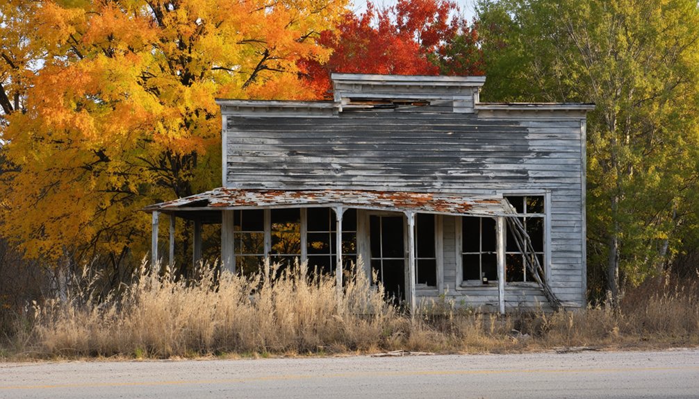
Cedar Point: A Mill Town Frozen in Time
Deep in the Flint Hills of Chase County, where the Cottonwood River carves through limestone bluffs, Cedar Point stands as a proof to Kansas’s mill town era. You’ll discover the 1875 limestone grist mill—a magnificent ruin that’s begged for artistic photography since railways bypassed this settlement in 1871.
When October’s amber light filters through empty windows, you’re witnessing seasonal photography gold against tallgrass prairies ablaze with russet and gold.
The town’s population crashed from 190 souls in 1920 to just 22 today. You’ll find Carpenter’s Garage still operating, a lonely Pepsi machine, and that 1916 Pratt Truss bridge spanning westward. Founded in 1862, Cedar Point once bustled with 113 residents by the 1880 Census before decline set in. Local preservationists are restoring the old mill to prevent complete collapse of this 1870s landmark. There’s no tourist trap veneer here—just authentic decay where O. H. Drinkwater’s waterwheel once turned, grinding wheat for a century before silence claimed everything.
Clements and Its Historic Stone Arch Bridge
Where the Cottonwood River bends through Chase County’s tallgrass prairies, you’ll find the limestone colossus that refuses to surrender—Clements Stone Arch Bridge, rising 40 feet above water that’s carved this valley since ice ages retreated.
Built in 1888 from Flint Hills stone, its double arches span 175 feet through autumn’s gold-and-crimson corridor.
You’ll walk where wagons once rattled—the roadbed now ends in a farmer’s field, closed to vehicles but open to wanderers.
The bridge served the settlement once called Hunt’s Station, a trading post that evolved into Crawfordsville after the Santa Fe Railroad arrived in 1881.
Recent floods dumped a football-field-length log jam against its flanks, creating preservation challenges that’d make architectural restoration experts wince.
Yet it stands, hidden in hackberry and cottonwood, while FEMA paperwork crawls forward and modern bridges steal priority.
The construction crews hoisted limestone blocks with a traveling derrick supporting nineteen tons on steel-wire cables—engineering ambition that’d make today’s contractors reconsider their equipment.
The tallgrass whispers around limestone that outlasts bureaucracy.
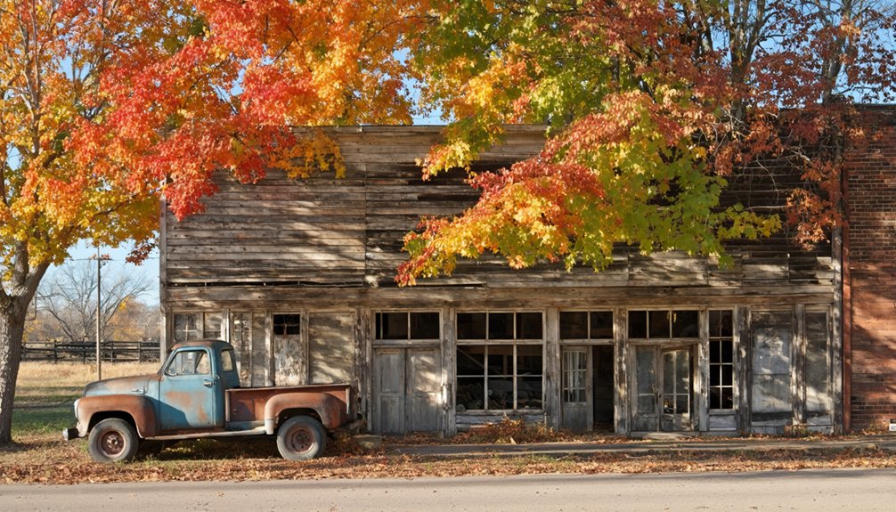
Elmdale’s Autumn Transformation
Along US Highway 50, between the river bends and prairie swells, Elmdale’s weathered limestone buildings catch October light like old photographs fading to sepia. You’ll find yourself wandering past two abandoned schools standing sentinel, their empty windows framing cottonwood trees ablaze in gold.
The 1898 bank building—survivor of the Great Depression—still anchors Main Street, its stone walls warm against fall’s crisp air.
While larger towns host crowded harvest festivals, Elmdale offers something rarer: solitude among history.
The Cottonwood River bottomland transforms into one of Kansas’s unexpected leaf peeping spots, where amber willows trace the floodplain that shaped this town’s fate. Approximately 50 residents still call this place home, keeping watch over the crumbling structures as prairie grass slowly reclaims what the floods left behind. The Elmdale Trading Post marks the entrance to this historic railroad town, established in the 1870s when steel rails first crossed the prairie.
You’re free to explore at your own pace, photography uninterrupted, with only the Methodist church bell marking Sunday mornings.
Diamond Creek: Hidden Santa Fe Trail Remnant
You’ll find Diamond Creek tucked away in Morris County’s rolling hills, where autumn maples blaze orange above the weathered trace of the Santa Fe Trail.
The springs that once saved countless travelers from the brutal stretch ahead—the aptly named Journey of the Dead—now bubble quietly beneath a canopy of gold and crimson leaves.
Locating this hidden remnant means traversing unmarked prairie paths where fallen foliage obscures the wagon ruts that once carried Missouri traders toward New Mexico’s distant mountains.
Stone ruins from the 1849 mail station—which once housed a hotel, restaurant, and blacksmith shop—still dot the landscape among the fall colors.
The route here follows where traders and freighters once navigated multiple lines of travel, their specific paths shifting with weather conditions and the ever-present dangers from hostile encounters.
Santa Fe Trail History
When William Becknell left Franklin, Missouri, in 1821 with just $300 in trade goods, he couldn’t have imagined his route would become the artery pumping life into the American Southwest for nearly six decades. The Santa Fe Trail stretched 900 miles across untamed territory, climbing from 500 feet to over 8,000 feet without a single bridge.
Historical trade routes like this carved freedom into the frontier, though not without cost. Twelve Native American tribes watched their lands bisected by endless wagon columns. Native American impacts intensified through the 1860s, forcing merchants to circle their caravans defensively. By 1829, military escorts began accompanying caravans after Major Riley received orders from President Jackson to protect traders from increasing Indian attacks.
You can still trace Becknell’s pioneering spirit along Kansas’s remaining trail segments, where autumn leaves now blanket the ruts worn deep by commerce-hungry wheels seeking opportunity beyond civilization’s edge. Over 150 historic sites remain preserved throughout Kansas, including visible wagon ruts and stream crossings that served as vital waypoints for traders.
Locating the Hidden Site
The best-preserved secret of the Santa Fe Trail hides behind a cattle gate thirteen miles west of Council Grove, where U.S. Highway 56 meets Kansas 149. You’ll find Diamond Spring on private ranchland, marked by a weathered sign most travelers speed past without noticing.
The “Diamond of the Plains” now feeds cattle through concrete cisterns—a far cry from George Sibley’s 1825 description of “perfectly accessible” crystal water that saved countless pioneers.
Local legends say Ben Jones’s original discovery sparked settlement here by 1830, but Missouri bushwhackers erased the town in 1863.
Today, stone ruins and an old cemetery whisper stories among the cottonwoods.
These cultural landmarks demand you leave pavement behind, respecting private property while chasing authentic frontier ghosts.
Autumn Landscape Challenges
Walking Diamond Creek’s valley in autumn reveals why photographers curse this historic site—prairie grasses steal the show from trees that barely exist. You’ll squint at sparse cottonwoods along the creek, hoping for that Instagram-worthy canopy that never materializes. The foliage density here couldn’t fill a postcard.
Morris County’s autumn weather compounds your frustration. Summer’s drought leaves whatever leaves manage to sprout looking crispy rather than crimson. You’re maneuvering uneven trail ruts while scanning for color that vanished weeks ago, your boots catching on remnants of wagon tracks where emigrants once worried about Comanche raids instead of leaf-peeping disappointments.
The spring still flows into its concrete trough, indifferent to your scenic expectations. This landscape refuses to perform on schedule.
Dunlap’s Dramatic Decline Through the Decades
After decades of vibrant commerce and community life, Dunlap’s fortunes began to fade in the early 1900s.
You’ll witness urban decay etched across three critical phases:
- 1940s-1960s Sharp Decline – The Great Depression hit Black workers hardest, triggering mass migration from rural Kansas to urban centers seeking opportunities beyond agricultural dependence.
- Post Office Closure (1988) – This final blow severed Dunlap’s connection to the wider world, marking its shift from struggling community to ghost town.
- Present Day – Fewer than 30 souls remain among overgrown houses and an empty gas station, where autumn leaves now blanket abandoned storefronts.
Yet historical preservation persists. The Dunlap Colored Cemetery, added to the National Register in 2018, honors 125-130 graves—silent testament to those who dared claim freedom’s promise here.
Planning Your Fall Ghost Town Adventure
Golden leaves crunch beneath your boots as you chart your route through Kansas’s abandoned settlements, where crisp October air carries whispers of forgotten Main Streets. Start in Chase County, where Cedar Point’s standing mill and Clements Stone Arch Bridge—currently undergoing preservation efforts—offer architectural treasures you’ll traverse on foot. Pack a county-by-county map from Wikipedia’s thorough lists, plotting Diamond Springs along the historic Santa Fe Trail.
You’ll encounter wildlife sightings near abandoned rail lines intersecting state refuges. Cool sunshine illuminates cemetery headstones marking ghost communities across Franklin and Osage counties.
If you need respite, Ellinwood’s Underground tours run $15, while the Historic Wolf Hotel serves Sunday dinners. Self-guided exploration lets you wander freely, capturing photographs where amber foliage frames forgotten doorways.
Frequently Asked Questions
What Photography Equipment Works Best for Capturing Ghost Town Fall Foliage?
Golden hour light vanishes fast—you’ll need equipment selection like Sony’s weather-sealed bodies and 16-35mm wide-angles. Master lighting techniques with polarizers enhancing amber leaves against weathered wood, while your 70-200mm compresses those hauntingly beautiful, freedom-soaked autumn scenes.
Are There Camping Facilities Near Chase County Ghost Towns?
You’ll find free primitive camping at Chase State Fishing Lake near these ghost towns, where local legends whisper through amber cottonwoods. Historic preservation efforts haven’t touched Elmdale’s crumbling facades, and Camp Wood YMCA offers comfortable cabins nearby.
Which Ghost Towns Allow Metal Detecting or Artifact Collecting?
Ironically, you’ll find freedom’s greatest where rules exist: Mertilla and unnamed pre-Civil War sites welcome detectors with landowner permission. Metal detecting laws require you follow artifact collection regulations—secure permission, use shallow tools, and you’re golden exploring Kansas’s abandoned treasures.
How Do Fall Foliage Peak Times Vary Across Kansas Counties?
You’ll witness seasonal leaf change progressing south and west across Kansas. Northern counties blaze gold by mid-October, while regional climate patterns delay southern and western areas until early November—nature’s freedom unfolds gradually across the prairie landscape.
What Wildlife Might Visitors Encounter While Exploring Abandoned Kansas Towns?
You’ll spot native birds like red-tailed hawks circling overhead and great horned owls perched in decaying rafters. Forest critters—raccoons, opossums, and white-tailed deer—roam freely through crumbling structures, reclaiming these forgotten spaces as their wild domain.
References
- https://thewanderingpigeon.com/2015/10/03/day-of-kansas-ghost-towns/
- https://www.travelks.com/blog/stories/post/13-most-haunted-places-in-kansas-you-must-visit-this-fall/
- https://www.youtube.com/watch?v=SyTlkr_4aFM
- https://en.wikipedia.org/wiki/List_of_ghost_towns_in_Kansas
- https://www.hhhistory.com/2019/05/ghost-towns-of-kansas.html
- https://legendsofkansas.com/leavenworth-county-extinct-towns/
- https://www.youtube.com/watch?v=e3D0OIQvQIc
- https://www.youtube.com/watch?v=89wwg5vBCfI
- https://backroadspress.com/_blog/just-wandering-through-cedar-point
- https://en.wikipedia.org/wiki/Cedar_Point


