You’ll find Vermont’s most atmospheric ghost towns framed by spectacular fall foliage in early October, when vibrant maples surround crumbling stone foundations at Ricker Basin and Plymouth 5 Corners. The abandoned mining settlement of Glastenbury Mountain offers eerie hiking through the “Bennington Triangle,” while Tyson Furnace’s 1835 iron works sit reclaimed by colorful forest near Somerset Reservoir. Emily’s Bridge in Stowe adds haunted ambiance to your foliage tour, with paranormal legends mixing with autumn beauty. The sections below reveal specific trails, peak timing, and photography strategies for each location.
Key Takeaways
- Ricker Basin features stone foundations and cellar holes along Stevenson Brook Trail, surrounded by vibrant maple trees glowing with October colors.
- Plymouth 5 Corners displays gold rush remnants including cellar holes, mill foundations, and mine shafts amid Okemo Valley’s spectacular fall foliage.
- Glastenbury Mountain ghost town, disincorporated in 1937, offers mysterious ruins accessible through trails framed by autumn’s colorful landscape.
- Tyson Furnace near Somerset Reservoir shows 1835 iron community remains with stone foundations now reclaimed by nature and fall colors.
- Early October provides optimal conditions for exploring Vermont’s ghost towns, combining peak foliage with moderate weather for photography and hiking.
Ricker Basin: Stone Foundations Along Scenic Trails
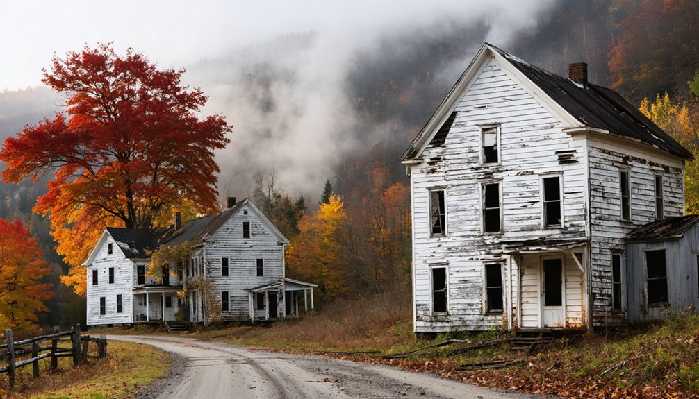
When autumn transforms Vermont’s mountains into a tapestry of crimson and gold, the forgotten settlement of Ricker Basin offers hikers a haunting glimpse into nineteenth-century frontier life.
You’ll discover stone foundations and cellar holes scattered along the Stevenson Brook Trail in Green Mountain National Forest, where fifty families once carved out existence on 4,000 unforgiving acres.
Along these weathered trails lie the scattered remains of fifty families who wrestled survival from four thousand merciless mountain acres.
Trail maintenance keeps paths accessible to landmarks like the Almeron Goodell farmhouse and three historic cemeteries.
You’ll find remnants of sawmills that powered the community’s timber economy, alongside crumbling foundations of the Gideon Ricker and Dom McCoy farms. The relentless rainfall of 1927 triggered catastrophic flooding that sealed the community’s fate, forcing the final abandonment of this mountain settlement.
The Waterberry Dam construction, completed in 1938, submerged portions of the old ruins beneath its reservoir while providing crucial flood control for the Wooki River valley.
Historical preservation efforts protect these sites from complete disappearance, though nature steadily reclaims what floods couldn’t destroy in 1927 and 1934.
Glastenbury: Vermont’s Most Mysterious Abandoned Town
While Ricker Basin’s stone foundations whisper of hardship and perseverance, Glastenbury Mountain harbors darker legends that’ve made it Vermont’s most infamous ghost town. You’ll find remnants of Fayville scattered through wilderness that once supported 241 souls during the charcoal boom. Vermont disincorporated this settlement in 1937, and the Forest Service claimed what remained—hardly an example of historic preservation.
The “Bennington Triangle” gained notoriety through mysterious disappearances between 1945-1950, when hikers vanished along mountain trails. Indigenous peoples warned of a “human-eating rock” here, and modern adventurers report disorienting experiences in these woods. Near the summit sits a mysterious stone cairn, human-built without any clear rational explanation.
Unlike typical urban decay, Glastenbury’s logging roads and abandoned communities blend into autumn foliage, creating an atmosphere where you’re genuinely free to explore Vermont’s most unsettling backcountry mystery. The town’s troubled past includes mysterious murders that contributed to its dark reputation alongside failed development schemes.
Plymouth 5 Corners: Cellar Holes Among Autumn Landscapes
You’ll find Plymouth 5 Corners nestled in Windsor County’s Okemo Valley, where stone-lined cellar holes emerge from beneath crimson maple and golden birch canopies each October. The ghost town’s preserved footpaths let you trace the routes miners took during the 1855-1860 gold rush, now bordered by brilliant foliage instead of bustling saloons and boarding houses.
Walk these quiet trails past remnants of the assayer office’s four-foot rock walls and imagine when this agricultural hamlet briefly transformed into Vermont’s answer to California’s goldfields. The settlement’s rapid rise began when William Hankerson’s sluicing discoveries sparked development of mills, stores, and entertainment venues before the boom town quickly collapsed into abandonment. The site once featured a gold mill that processed ore during the brief but intense mining activity of the 1850s.
Stone-Lined Historical Foundations
Hidden beneath Vermont’s crimson and gold canopy, the stone-lined cellar holes of Plymouth Five Corners tell the story of a boom-and-bust gold rush that transformed a quiet farming village into a bustling mining town.
You’ll discover these historical preservation sites scattered throughout Camp Plymouth State Park, where building foundations mark former hotels, mills, and homes from the 1850s rush.
Stone walls and forges dot the landscape alongside collapsed mine shafts like the Fox Mine.
The foliage photography opportunities here are exceptional—autumn’s vibrant colors frame these forgotten foundations, creating powerful contrasts between nature’s renewal and human abandonment.
These remnants serve as historical reminders of the transient, boom-and-bust nature of towns based on resource industries that couldn’t withstand economic shifts.
Footpaths from the gold panning era still wind through the terrain, connecting cellar holes where prospectors once dreamed of striking it rich in Vermont’s backcountry.
Originally known as Salstash in the late 1780s, this small farming community experienced its brief transformation when William Henderson discovered gold in 1858.
Quiet Rural Setting Returns
The gold fever that once consumed Plymouth Five Corners burned out as quickly as it ignited, and by the early 1900s, nature began reclaiming what prospectors left behind. Today, you’ll find a virtual ghost town where autumn maples stand sentinel over forgotten dreams. The old cemetery persists among brilliant fall colors, while Camp Plymouth State Park preserves the Fox Mine’s crumbling shafts and rusty rails.
What you’ll discover wandering these quiet grounds:
- Four-foot rock walls marking the assayer office foundation—once bustling with fortune seekers testing their finds
- Railroad ties rotting beneath crimson leaves where horse-drawn ore carts once rattled
- Stone-lined cellar holes emerging through October mist
Historical preservation meets landscape photography here, where peaceful farmland has swallowed a boomtown’s ambitions whole. The community once supported hotels, schools, and dance halls serving over 100 miners who made Bridgewater’s main industry gold extraction rather than agriculture during the 1850s mining boom. The enigmatic Henry Fox worked alone at the Rooks Mine as a hermit for nearly three decades until his death in 1919 marked the final chapter of Plymouth’s gold mining era.
Footpaths Through Fall Foliage
Where autumn transforms abandoned roads into corridors of amber and rust, Plymouth Five Corners reveals itself through a network of trails that weren’t built for hikers—they’re the actual streets where miners once walked home from twelve-hour shifts.
You’ll find old maple trees lining these forgotten pathways, their canopies ablaze with October color above cellar holes and crumbling foundations. The Arthur Davis Wildlife Management Area encompasses most of this terrain, offering miles of graded roads connecting Plymouth, Reading, and Woodstock.
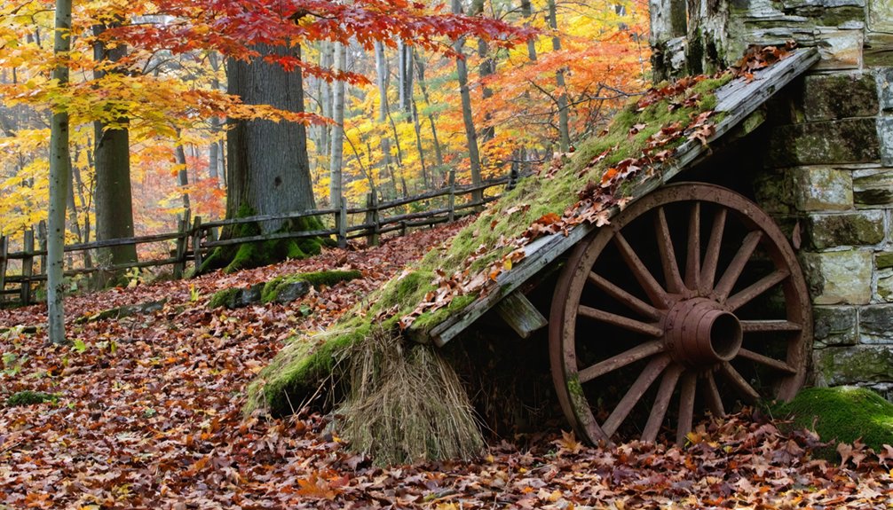
Archaeological findings dot the landscape—handmade bricks from the 1840s, mine shaft entrances, cemetery stones—each discovery a monument to cultural preservation through abandonment rather than restoration.
Access starts at the Colby Pond trailhead, where mountain bikers and hikers follow routes that served a community of 100 gold miners.
Smith Family Farms: Hidden Remnants in the Woods
Deep in Vermont’s Green Mountains, generations of Smith family farmers carved homesteads from wilderness that autumn now reclaims in brilliant color. You’ll discover these farmstead remnants along wood roads near Rochester, where the abandoned Chester M. Smith site sits at 1900 feet on Mt. Horrid’s east slope. Stone structures and orchard ruins emerge from forests that’ve consumed 200-acre lots first cleared in 1791.
Three remnants worth seeking:
- Kinsman homestead foundations accessible via Forest Service Road 113, where maples blaze against crumbling chimneys
- Stephen Gleason Tavern site in Shrewsbury, operating until 1835 before the town banned spirits
- Hidden cheese factory ruins scattered across three locations, markers to post-dairy transitions
These ghost farms offer solitude autumn hikers crave—freedom through forgotten pathways.
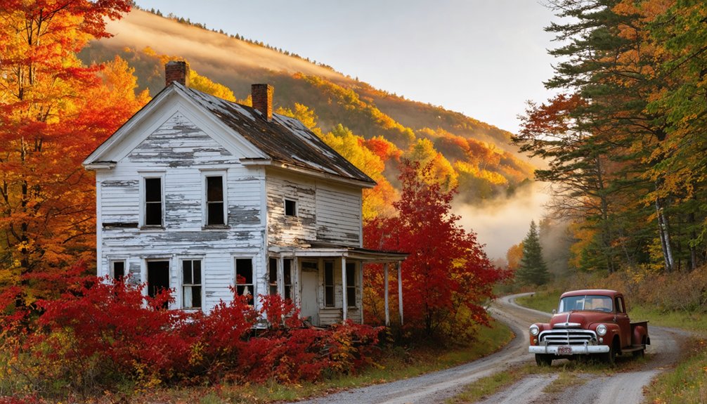
Tyson Furnace: Remote Ghost Town Near Somerset Reservoir
Along Vermont’s Route 100 where Echo Lake reflects October’s crimson maples, you’ll find remnants of an industrial experiment that once defied wilderness. Isaac Tyson’s 1835 iron furnace transformed this remote valley into America’s first anthracite-coal processing site.
Where crimson October maples meet Echo Lake, stone remnants whisper of Isaac Tyson’s audacious 1835 industrial vision amid Vermont wilderness.
This area eventually housed 175 workers in a self-contained company town.
Today, stone foundations peek through fallen leaves near the still-operating Echo Lake Inn. The archaeological significance lies hidden—a hillside cemetery tucked near Somerset Reservoir, cellar holes marking where physicians and merchants once thrived.
Historical preservation efforts catalog these scattered ruins, though nature’s reclaimed most evidence of the bustling operation that supplied Civil War gunboats.
Hike these wooded paths during peak foliage, when autumn colors frame what remains of Vermont’s forgotten industrial frontier.
Emily’s Bridge: Stowe’s Haunted Covered Bridge
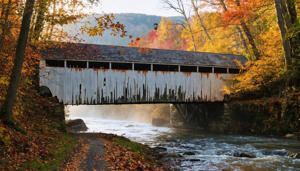
You’ll find Gold Brook Covered Bridge just outside Stowe, where autumn transforms the 1844 structure into a scene framed by blazing maples and golden birches.
The bridge gained its darker name from Emily, a jilted bride who allegedly hanged herself from the rafters after her lover failed to appear for their midnight elopement.
Local visitors report scratches on car doors, phantom handprints on foggy windshields, and apparitions of a woman in white—encounters that intensify during October when the veil between worlds feels thinnest along Gold Brook’s mist-shrouded banks.
The Legend of Emily
When autumn mist settles over Gold Brook in Stowe, the weathered timbers of Vermont’s oldest covered bridge seem to hold more than just structural history.
You’ll find Emily’s story woven into local legends—a tale of forbidden love from the mid-1800s that defies historical preservation records.
The legend unfolds in three haunting acts:
- The Midnight Plan: Emily arranged a secret elopement at the bridge, defying her family’s social expectations
- The Betrayal: Her lover never appeared, leaving her waiting in darkness beneath the Howe Truss rafters
- The Tragedy: Consumed by despair, she reportedly hanged herself from the very beams that shelter travelers today
No death records confirm Emily’s existence, yet her name draws freedom-seekers nationwide to this 1844 span, where folklore trumps fact.
Paranormal Activity and Encounters
Whether Emily existed or not, something lingers at Gold Brook Bridge that transforms skeptics into believers. You’ll hear disembodied cries for help echoing through the tunnel, witness phantom white lights flashing without source, and feel sudden temperature drops that raise your neck hairs.
Paranormal theories suggest a vengeful spirit—visitors report unexplained scratches appearing on their skin and claw marks gouging their cars’ paint. You might catch a ghostly apparition near the bridge or experience door handles jiggling as something tries entering your vehicle.
Investigators document foggy windshields marked with handprints, photos revealing mysterious figures, and phantom music drifting from Gold Brook below. These ghostly legends persist across decades, with documented encounters dating back to 1948, making this covered bridge Vermont’s most actively haunted location.
Visiting During Autumn Season
As Vermont’s fall foliage reaches its peak in late September through mid-October, Emily’s Bridge becomes framed by nature’s most dramatic canvas. You’ll find this 1844 structure surrounded by glowing gold and crimson maples, creating an irresistible opportunity for autumn photography while honoring its historical preservation.
Your visit should include:
- Morning golden hour shoots – Capture sunlight filtering through the bridge’s weathered frame against brilliant foliage.
- The winding approach – Experience curves and dips through tunnel-like trees ablaze with seasonal color.
- Daytime exploration only – Town ordinances restrict nighttime access, though daylight reveals the bridge’s rustic character without restrictions.
The single-lane crossing creaks beneath your footsteps, its dark wood contrasting sharply with autumn’s vibrant palette. You’re free to explore this National Register site during daylight hours.
Best Times to Visit Vermont’s Abandoned Sites
Weather considerations considerably impact your ghost town adventures. Early October delivers moderate temperatures ideal for hiking to remote foundations and cemeteries.
While September visits might reward you with solitude, they often have incomplete color changes. Pack layered clothing for mountain elevations where temperatures fluctuate dramatically.
After rainfall, stone foundations and trails become treacherous—proper footwear isn’t optional.
Southern locations like Manchester typically peak earlier than northern sites near Stowe, giving you flexibility in planning your abandoned settlement circuit.
Photography Tips for Ghost Towns in Fall Colors
Essential lighting techniques for emotional impact:
- Frame decaying doorways with fiery foliage overlays – the juxtaposition of life and decay creates powerful narrative tension.
- Position low near calm waters to capture mirror reflections of abandoned mills surrounded by autumn glory.
- Shoot through broken windows where golden leaf canopies flood forgotten interiors with nature’s reclamation story.
Use your polarizing filter on wet leaves and rusted metal surfaces to reduce glare while exploring remote, overgrown sites.
Planning Your Ghost Town and Foliage Adventure
When should you venture into Vermont’s forgotten settlements to catch both peak foliage and ideal ghost town exploration? Target mid-September through mid-October when crimson, orange, and yellow hues transform abandoned sites into photographer’s dreams.
Post-Labor Day Weekend offers perfect conditions as dropped leaves reveal hidden cellar holes and stone foundations you’d miss in summer’s dense growth.
Photography techniques benefit from autumn’s slanting light filtering through bare branches at sites like Ricker Basin and Somerset.
Pack layers for unpredictable mountain weather and start hikes early to maximize daylight hours.
Wildlife encounters increase during fall as deer and birds forage before winter.
Prepare for Glastenbury’s vast wilderness with proper navigation tools—that summit cairn becomes essential when fog rolls in.
Respect active roadways like Emily’s Bridge while exploring these hauntingly beautiful relics.
Frequently Asked Questions
Are There Any Safety Concerns When Exploring Vermont’s Abandoned Ghost Towns?
You’ll face real dangers: crumbling foundations, unstable structures, and remote locations limit rescue access. While historical preservation efforts help, many sites lack proper cleanup. Watch for hidden cellar holes, weakened floors, and steep terrain—especially during Vermont’s unpredictable autumn weather.
Can I Camp Overnight Near These Ghost Town Locations?
Picture your tent nestled beneath crimson maples near crumbling foundations. You’ll find designated campsites at Little River State Park and backcountry spots in Green Mountain National Forest, offering historical preservation views and photography opportunities while respecting Vermont’s wild, unregulated beauty.
Are the Ghost Town Sites Wheelchair Accessible?
Unfortunately, you’ll find these ghost towns aren’t wheelchair accessible—they’re reached via rugged forest trails and uneven terrain. However, roadside pulloffs near trailheads offer photography opportunities of Vermont’s historical preservation efforts amid stunning fall foliage without hiking.
Do I Need Permits to Visit These Abandoned Locations?
Most sites need only basic park entry fees, while historical preservation protects these ruins from disturbance. You’ll find freedom exploring state parks and national forests without special permission requirements—just respect seasonal closures and Leave No Trace principles during your autumn adventures.
What Wildlife Might I Encounter While Exploring These Areas?
You’ll encounter impressive wildlife diversity—black bears foraging, moose near wetlands, and soaring turkey vultures. Seasonal migrations bring monarch butterflies and warblers through these abandoned sites. Watch for deer, foxes, and remember Vermont’s timber rattlesnakes in rocky areas.
References
- https://www.islands.com/1965435/stowe-vermont-emilys-bridge-new-england-attraction-blending-haunting-lore-fall-travel-charm/
- https://vermontbandbinn.com/blog/haunted-vermont/
- https://www.youtube.com/watch?v=2fvPo9iQC-w
- https://www.vermonter.com/ricker-basin-vermont-ghost-town/
- https://vermontvacation.com/haunted-vt/
- https://happyvermont.com/2014/10/23/glastenbury-ghost-town/
- https://www.youtube.com/watch?v=m8FRx55xICM
- https://ournewenglandlegends.com/podcast-409-the-ghost-town-of-ricker-basin/
- https://obscurevermont.com/tag/ricker-mills/
- https://www.onlyinyourstate.com/experiences/vermont/the-vermont-ghost-town-thats-perfect-for-an-autumn-day-trip


