You’ll find West Virginia’s most spectacular ghost town autumn displays along the New River Gorge’s 12-mile stretch, where over 60 abandoned coal communities emerge from crimson and gold forests each October. Thurmond’s 1904 depot—still serving Amtrak—frames perfectly against fiery maples, while Kaymoor’s 821 wooden stairs descend through blazing hickories to moss-covered tipples and coke ovens. Peak colors arrive mid-October at these lower elevations, though higher sites like Spruce Knob transform by late September. Proper timing and route selection reveal West Virginia’s most dramatic intersection of industrial heritage and seasonal beauty.
Key Takeaways
- Thurmond, the most accessible ghost town, peaks with fall colors in mid-October along the New River Gorge’s 12-mile stretch.
- Over 60 ghost towns feature abandoned coal structures framed by crimson maples and golden hickories during autumn months.
- Kaymoor offers three trail routes through coal ruins, with bike-accessible paths showcasing vibrant seasonal foliage and industrial remnants.
- Nuttallburg’s foundations and viewpoints provide scenic overlooks of layered ridges displaying reds and golds throughout October.
- Brooklyn Mine Trail spans 2.7 miles through abandoned rail corridors where rusted tracks disappear beneath tunnels of fiery autumn colors.
Understanding Peak Fall Color Timing Across West Virginia Elevations
When September’s first cold snap rolls through West Virginia’s highest peaks, the transformation begins at Spruce Knob’s 4,863-foot summit while valley floors still bask in summer warmth. You’ll witness elevation trends that create a cascading wave of color—Dolly Sods and Bear Rocks ignite in late September at 4,000 feet, their blueberry bushes blazing red first.
Peak timing shifts dramatically with every thousand feet you descend. Canaan Valley at 3,200 feet doesn’t reach its October 14 climax until Spruce Knob’s leaves have already fallen.
The river valleys around Parsons lag two full weeks behind the highlands. Tucker County’s 2,000-foot elevation span gives you flexibility—chase Dolly Sods’ wilderness spectacle early October, then drop to Seneca Rocks for mid-to-late October gold. Blackwater Falls displays vibrant colors from late September through early October, bridging the gap between highland and mid-elevation viewing opportunities. Frost and cold nights trigger the most dramatic color changes, transforming moderate yellows into brilliant reds and oranges within days.
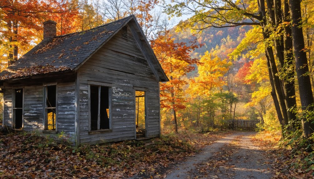
Most Accessible Ghost Towns in the New River Gorge Region
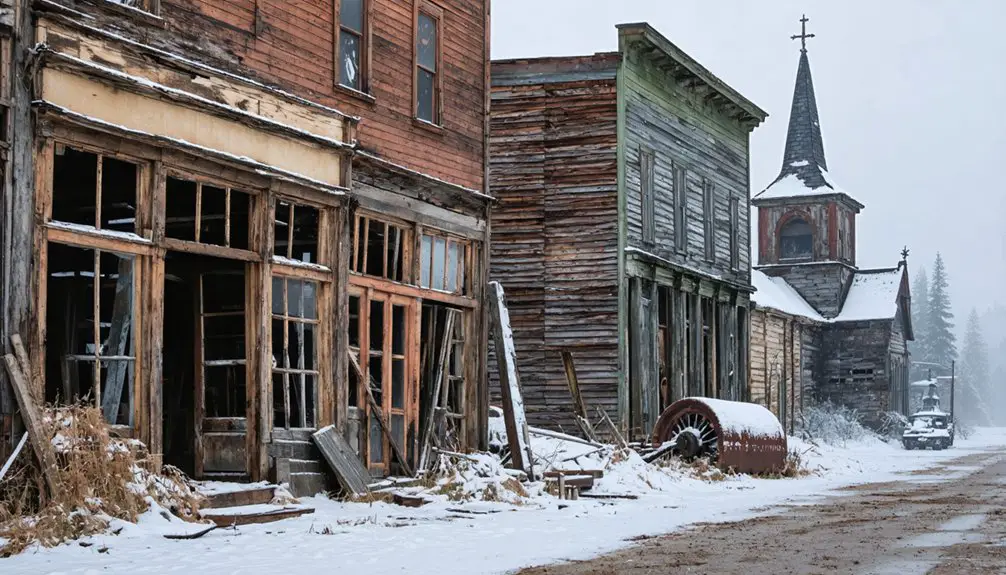
Where coal once powered America’s industrial heartbeat, more than 60 ghost towns now slumber along a dozen-mile stretch of the New River Gorge, their sandstone foundations emerging through autumn’s crimson understory. You’ll find Thurmond most accessible—a 4-resident municipality where the train depot serves as your National Park Service visitor center. Its preserved hotels and bank structures stand proof to industrial heritage predating today’s urban renewal.
Kaymoor offers three trail options, including the bike-accessible Cunard-Kaymoor route, while challenging explorers can descend 821 stairs through mining ruins. During its 1920s peak, Thurmond processed more coal traffic than Cincinnati, Ohio, establishing the gorge as a crucial artery in America’s energy distribution network.
Nuttallburg provides marked foundations and Double Z rapid viewpoints. The main mining complex lies roughly 400 feet into the gorge, with additional ruins extending further below railroad level. The National Park Service maintains these sites with informative signage and improved infrastructure, transforming what coal prospectors developed after 1873 into accessible portals through West Virginia’s unvarnished past.
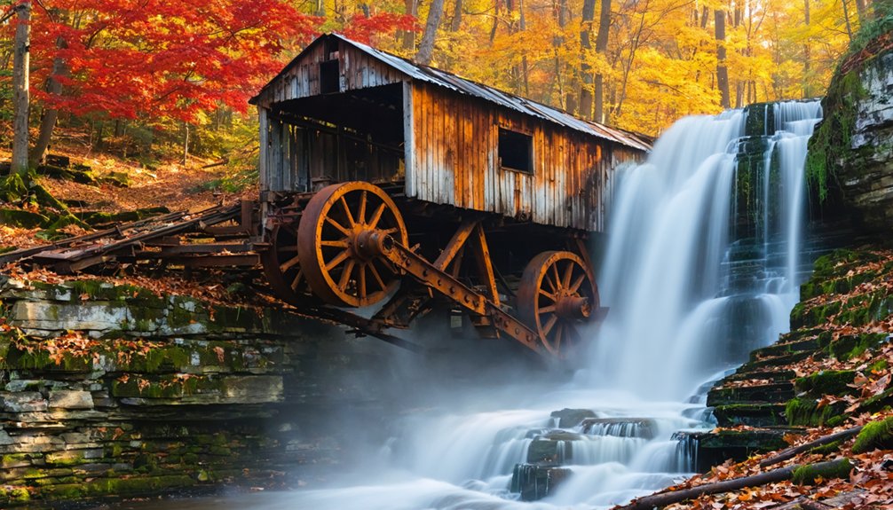
Nuttallburg: A Complete Coal Mining Site Surrounded by Autumn Beauty
Along the serpentine banks where Keeneys Creek surrenders to the New River, England-born entrepreneur John Nuttall glimpsed West Virginia’s black gold future in 1870, purchasing 1,500 acres of gorge land at $1-$8 per acre before the Chesapeake & Ohio Railway punched through three years later.
You’ll discover America’s most intact coal-mining complex here, where industrial ruins stand frozen in time beneath autumn’s crimson canopy.
Henry Ford himself modernized these operations in the 1920s, constructing the world’s largest mechanized mine before railroad disputes ended his vertical integration dreams. His innovations included installing a 1,385-foot conveyor that transported coal to the Henry Ford Tipple for efficient train loading.
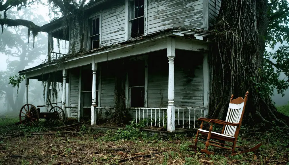
The National Park Service acquired this site in 1998, stabilizing structures that once housed 342 residents across 110 company dwellings. Listed on the National Register in 2005, Nuttallburg stands as one of West Virginia’s most complete coal-related industrial sites.
Mining history breathes through every weathered timber and rusting tipple you’ll encounter along this dead-end road.
Thurmond: Historic Rail Town Gateway to Fall Adventures
You’ll find Thurmond frozen in time along the C&O Railroad tracks, where a town that once moved more coal than Cincinnati now sits eerily quiet with just five residents. The restored depot—still an active Amtrak stop—anchors a collection of weathered hotels, the old National Bank, and mine remnants that tell the story of West Virginia’s explosive 1920s boom.
During its peak between 1900 and the 1920s, Thurman welcomed 75,000+ annual visitors who arrived on up to 15 trains daily at this bustling railway depot. The town earned its reputation as the “Las Vegas” of its era, complete with the robberies and mayhem that characterized this wild railroad hub. When autumn gilds the surrounding gorge, you can walk past rusting conveyor belts and abandoned storefronts while fall colors blaze across the hillsides that witnessed this railroad town’s meteoric rise and inevitable fall.
Exploring Thurmond’s Abandoned Structures
While autumn leaves paint the surrounding mountains in brilliant reds and golds, Thurmond’s abandoned industrial structures stand as stark monuments to the town’s vanished prosperity.
You’ll discover the 1922 coaling tower—a reinforced concrete giant where coal once cascaded into steam locomotive tenders. Abandoned warehouses line the tracks, their empty windows framing views of rust-colored hillsides.
The foundations of two demolished water tanks still mark where 310,000 gallons once fed the railroad’s thirst.
Among these historic landmarks, the crumbling Goodman-Kincaid Building and National Bank of Thurmond reveal different stories. The 1906 structures housed everything from telephone exchanges to doctor’s offices before their roofs surrendered to time.
The devastating fires of 1922 destroyed the entire south side of town, forcing many businesses to relocate and beginning Thurmond’s long decline. The Armour Meatpacking Plant, which operated from 1905 to 1932 with processing facilities below and employee apartments above, met its own fiery end in 1963.
You’re free to photograph these skeletal remains, where nature’s reclaiming what boom-time ambition built.
Railroad Heritage and Depot
Standing at the heart of Thurmond’s renaissance as a heritage destination, the 1904 Chesapeake & Ohio Railway depot anchors a railroad legacy that once moved more freight tonnage than Cincinnati or Richmond.
You’ll discover National Park Service historical preservation efforts that transformed this coal-era hub into a visitor center, where exhibits chronicle operations that handled $4.8 million in coal revenue and served 95,000 passengers yearly.
The depot replaced an 1899 structure lost to fire, emerging as command center for 150+ railroad workers and 18 train crews.
Today, trails radiating from this restored station lead you through wildlife habitats reclaiming abandoned yards where diesel’s arrival ended steam-era prosperity.
Walk these quiet rails where occasional Amtrak trains still pass, connecting past industrial might with present wilderness solitude.
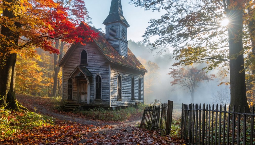
Seasonal Color Along Tracks
As October transforms the New River Gorge into a tapestry of crimson and gold, Thurmond’s abandoned rail corridors become nature’s gallery where rusted tracks disappear beneath tunnels of blazing maples and hickories.
You’ll walk where coal trains once rumbled, following iron paths now claimed by seasonal bloom that erupts in fiery reds and amber yellows. The Brooklyn Mine Trail offers 2.7 miles of freedom—hike, bike, or ride horseback past forgotten mining operations framed by autumn’s fierce palette.
Mid-October delivers peak colors at these lower elevations, though weather patterns shift timing yearly. Check live foliage maps before your journey.
Unlike winter migration patterns that empty these hollows, fall draws wanderers seeking connection with both natural splendor and coal country’s defiant legacy etched in weathered railroad ties.
Hiking to Remote Ghost Towns: Kaymoor and Dun Glen Trails
The wooden steps beneath your boots once carried coal miners to and from their shifts in the depths of Kaymoor, where James Kay’s Low Moor Iron Company extracted black gold from West Virginia’s mountains for nearly sixty years.
You’ll descend 821 wooden stairs through switchbacks and rocky terrain, dropping 900 feet to reach the abandoned ruins—steel tipples, stone powerhouses, and coke ovens reclaimed by moss and mountain.
The trail passes rusted rails from the old haulage system, silent witnesses to 800 workers who once filled these hollows.
Local folklore whispers through the gorge walls, and winter wildlife tracks mark paths between crumbling structures.
It’s a strenuous climb back up, but you’ll earn those views of industrial history surrendering to Appalachian wilderness.
Combining Waterfalls and Fall Foliage Near Abandoned Mining Communities
Where smokeless coal once blackened the skies above Nuttallburg, Cathedral Falls now plunges 60 feet through a seasonal amphitheater of crimson maples and golden birch.
You’ll discover New River Gorge‘s ghost towns become gateways to waterfall exploration when autumn transforms the landscape.
- Glade Creek cascades tumble past Thurmond’s abandoned depot, where local flora reclaims railroad switching yards in brilliant October displays.
- Sandstone Falls near Hinton anchors routes connecting multiple coal camps, offering wide panoramas framed by seasonal wildlife migrations.
- Brooks Falls flows within hiking distance of Kaymoor’s 821-step descent, doubling your reward for the challenging terrain.
- Mill Creek waterfalls thread through Raleigh County’s forgotten mining corridors, where water once powered coal operations.
These combinations let you chart your own course through Appalachia’s layered heritage.
Scenic Overlooks and Natural Formations Enhanced by October Colors
You’ll find West Virginia’s autumn drama intensifies where ancient rock formations meet October’s palette—nowhere more striking than at Seneca Rocks, where 900-foot-high Tuscarora sandstone fins pierce the sky. While surrounding maples and oaks blaze crimson below, the scene becomes even more breathtaking.
The canyon rim viewpoints along nearby Routes 33 and 48 reveal layer upon layer of forested ridges transformed into waves of gold and orange. Their colors are made more vivid against the gray limestone cliffs that mark former mining territories.
These elevated vantages connect the state’s geological story with its industrial past. Overlooks near abandoned coal communities frame both natural formations and the human history carved into these October-painted mountains.
Seneca Rocks Autumn Display
Rising nearly 900 feet above the North Fork Valley, Seneca Rocks’ ancient quartzite fins transform into a photographer’s dream each October when the surrounding Potomac Highlands ignite with crimson and gold.
You’ll find peak fall colors typically arriving late September through early October at these higher elevations, where dawn fog intensifies the vibrant hues.
The 1.3-mile trail delivers:
- Panoramic vistas from the observation deck showcasing mountains dressed in deep crimsons and bright yellows
- Early morning photography opportunities when dew enhances foliage vibrancy
- Access to world-class rock climbing routes through dramatic autumn scenery
- Picnic spots amid October’s natural splendor at the summit platform
This Monongahela National Forest landmark offers unfettered exploration year-round, with Discovery Center trail maps guiding your independent adventures through West Virginia’s untamed backcountry.
Canyon Rim Viewpoints
From the ancient quartzite of Seneca to the carved depths of New River Gorge, West Virginia’s geological drama reaches its autumn crescendo at Canyon Rim’s dramatic overlooks. You’ll navigate 178 wooden steps descending from the visitor center—each drop revealing more of the gorge’s 876-foot vertical expanse where October’s fire paints sandstone cliffs in rust and gold.
These canyon viewpoints expose Wolf Creek’s cascades merging with the ancient river below, while gorge vistas stretch two miles southward through layers of geological time. The accessible boardwalk serves those seeking level passage, but stair-climbers earn unobstructed perspectives of this 300-million-year-old chasm.
Here, where water carved freedom through Appalachian bedrock, autumn’s palette illuminates the patient work of centuries.
Planning Your Ghost Town and Fall Foliage Road Trip
When planning a ghost town expedition through West Virginia’s autumn landscape, timing becomes your most critical variable. Higher elevations above 3,500 feet ignite first—Spruce Knob transforms in late September while mid-elevation sites like Nuttallburg peak mid-October. Check WV Tourism’s live foliage map before departure.
Your logistics demand deliberate preparation:
- Download offline maps—Nuttallburg’s winding dirt access offers zero cell service.
- Pack 4WD essentials for Sewell’s rugged approach near Babcock State Park.
- Wear blaze orange during hunting season at remote sites like Sherwood.
- Coordinate multi-day routes linking Fayette County’s concentrated ghost towns with Potomac Highlands foliage.
National Park Service manages Thurmond, Kaymoor, and Nuttallburg without trespassing concerns. Rangers provide Sewell directions.
Leave early—October’s compressed daylight limits exploration time at 821-stair descents and overgrown coal-era structures.
Frequently Asked Questions
Are Pets Allowed on Ghost Town Trails in New River Gorge?
Yes, you’ll find pets welcome on ghost town trails throughout New River Gorge’s 70,000 acres. Just follow leash regulations and prioritize pet safety—your four-legged explorer needs water while discovering these abandoned coal mining remnants among autumn’s blazing colors.
What Photography Equipment Works Best for Capturing Ghost Towns in Fall?
You’ll want weather-sealed cameras with wide-angle lens selection (16-35mm) for expansive abandoned structures, plus telephoto options (70-200mm) for isolating details. Proper camera settings—polarizers for autumn color saturation and tripods for golden-hour stability—capture West Virginia’s haunting beauty perfectly.
Are There Guided Tours Available for West Virginia Ghost Town Exploration?
You’ll find guided tours at Harpers Ferry focusing on historical preservation and paranormal history, but most ghost towns require self-directed urban exploration. The National Park Service protects New River Gorge sites, though you’re free to wander them independently.
Can Visitors Enter the Abandoned Buildings at Coal Mining Sites?
While time has frozen these coal towns in amber, you can’t enter most abandoned buildings due to preservation efforts and safety concerns. You’ll explore foundations, exteriors, and marked ruins instead, though haunted legends add mystery to your outdoor wanderings.
What Safety Precautions Should Hikers Take When Exploring Ghost Town Ruins?
You’ll need solid navigation skills and constant hazard awareness when exploring West Virginia’s abandoned coal camps. Wear sturdy boots, test rotted floorboards carefully, bring emergency supplies, and always tell someone where you’re venturing into these forsaken hollows.
References
- https://krismariawanders.com/best-places-for-fall-colors-in-west-virginia-what-to-do-there/
- https://wvexplorer.com/2025/10/19/ghost-towns-in-southern-west-virginia/
- https://en.wikipedia.org/wiki/List_of_ghost_towns_in_West_Virginia
- https://wvtourism.com/5-wv-ghost-towns/
- https://www.youtube.com/watch?v=Upekk1DDZeE
- https://www.youtube.com/watch?v=6LiI8WDMoec
- https://www.wvnews.com/leaf-peeping-lore-and-landscapes-fall-adventures-await-in-west-virginia/article_d9eaa37f-990e-430f-ab07-f8b8db05323d.html
- https://www.wvlogcabins.com/news/top-destinations-fall-foliage-in-west-virginia/
- https://gettuckered.com/peak-fall-color-timing-in-tucker-county-west-virginia/
- https://www.explorefall.com/states/west-virginia.html