You’ll find Goldroad, Arizona as a fascinating ghost town established after José Jerez’s 1899 gold discovery. This once-thriving mining settlement produced over $7 million in gold from 1903-1942 and housed up to 2,000 residents along the original Route 66. The town was deliberately razed in 1949 for tax purposes, leaving only crumbling foundations and a historic cemetery. The ruins demand extreme caution due to numerous structural hazards and unmarked mining shafts.
Key Takeaways
- Goldroad began as a gold mining town in 1899 after Jose Jerez discovered gold-bearing quartz that yielded 40-48 ounces per ton.
- The mining operation produced over $7 million in gold between 1904-1931, with the town reaching a peak population of about 400 residents.
- Route 66 initially passed through Goldroad, helping sustain the community despite mining declines until a 1952 realignment.
- The entire town was deliberately razed in 1949 for tax purposes, contributing significantly to its ghost town status.
- Today, visitors can explore crumbling mill foundations and mining artifacts, though numerous safety hazards exist from unstable structures and exposed shafts.
The Gold Discovery That Launched a Boomtown
A handful of gold-bearing quartz in 1899 forever changed Arizona’s mining history when Jose Jerez made his legendary discovery near what would become Goldroad.
While early prospectors, including John Moss in the 1860s, found traces of gold before abandoning them for silver elsewhere, Jerez’s find catalyzed a genuine gold rush.
Working on Henry Lovin’s grubstake, Jerez reportedly discovered the rich ore when he broke off a rock to throw at his stubborn burro.
The assayed ore yielded an astounding 40-48 ounces per ton, ranking among Arizona’s richest discoveries.
Within two years, Jerez and Lovin sold their claims for $50,000 to California investors who quickly established a $1.5 million mining corporation.
Mining legends tell how Jerez later worked as a laborer in the very mine he discovered.
The Burkhardt group’s sale of claims for $275,000 demonstrated the significant economic activity that developed rapidly in the Oatman Mining District.
The town of Goldroad reached its peak population of about 400 residents during the second mining boom around 1911 after reopening under new ownership.
Mining Operations and Early Development
While the initial gold discoveries near Goldroad occurred in the 1860s, substantial mining operations didn’t materialize until the early 1900s when development surged following Jose Jerez’s momentous find.
The Goldroad area remained largely untapped until Jose Jerez’s discovery sparked a mining boom in the early 1900s.
The Gold Road Mining & Explorations Company established early operations after striking rich ore in 1900, developing four main shafts that would eventually extend to impressive depths of 900 feet with over 18,000 feet of underground workings. The mine featured a characteristic gold-bearing vein that strikes N50W and dips 80-85 degrees northeast through the surrounding rock formations.
The mining equipment at Goldroad was state-of-the-art for its time, featuring a rock crusher plant and a mill equipped with cyanide processing capabilities. These facilities were strategically positioned near the Billy Bryan shaft. Though the high-grade ore was largely exhausted by 1907, leading to a mine collapse that temporarily halted operations.
Production flourished between 1904 and 1915, yielding over $6.6 million in gold from the expansive Gold Road Vein that measured over 6,560 feet long within a fault zone in latite.
Daily Life in a Company Mining Town
Goldroad’s bustling mining operations required a substantial workforce, leading to the establishment of a company town designed to support the daily needs of its residents.
Your housing quality reflected your status – workers lived in canvas structures with tin roofs, while foremen enjoyed stone-walled homes with amenities like pianos and libraries. This stratification epitomized mining culture‘s rigid hierarchy.
Despite the harsh desert conditions, community dynamics fostered security and cohesion. You’d socialize at Lovin’s Goldroad Club or shop at the mercantile store. The town’s Mexican influence was evident in local cuisine and cultural celebrations, reflecting the diverse heritage that gave Goldroad its Spanish name meaning garlic.
While census data reveals the town’s evolution from mainly mining jobs to more diverse occupations, including mechanics and farmers, employment remained tethered to the mine’s prosperity.
The population peaked between 1,500-2,000 residents in the 1910s, creating a temporary yet surprisingly stable social fabric despite the transient nature of mining communities. The town yielded approximately $10 million in gold during its productive years, contributing significantly to America’s economy during World War I.
Route 66 Connection and Transportation History
Route 66’s alignment through Arizona’s mining territory transformed Goldroad into a crucial transportation hub, with the treacherous mountain passage near Sitgreaves Pass challenging even the most experienced drivers.
You’ll discover that freight transportation along this section once required over one hundred horses for hauling supplies between Kingman and various mining camps, establishing essential commercial connections throughout the region.
The Great Depression era witnessed significant changes in traffic patterns as desperate migrants used this dangerous mountain route while seeking opportunities further west, simultaneously keeping small communities like Goldroad temporarily viable despite declining mining operations. The crazy switchbacks made the journey particularly hazardous for travelers unfamiliar with the terrain. The highway’s passage through Oatman to Kingman connected vital mining communities that would later become famous attractions along the historic route.
Highway Evolution Timeline
Although often overshadowed by its mining history, Goldroad’s geographical significance emerged through its position along evolving transportation networks that ultimately included the iconic Route 66. The area’s transportation chronicle began with the National Old Trails Road, an early transcontinental route that established key highway milestones before 1926.
When Route 66 officially incorporated segments of these older pathways in 1926, traffic patterns through Goldroad intensified, bringing automotive travelers directly past the mining settlement. Drivers experienced the challenging terrain of Sitgreaves Pass, which remained notorious among travelers seeking adventure on the Main Street of America.
The treacherous Sitgreaves Pass section featured narrow lanes and dangerous switchbacks that characterized early mountain highway engineering. The 1952 realignment proved pivotal—designed for improved safety, this bypass redirected vehicles away from Goldroad, coinciding with the mines’ closure and accelerating the town’s abandonment. The razing of the town in 1949 for tax purposes further contributed to its status as a ghost town.
Today, remnants of the original alignment preserve this transportation legacy.
Perilous Mountain Passage
The perilous passage through the Black Mountains represents one of the most challenging sections along the historic Route 66 corridor, with Goldroad situated at a critical juncture of this treacherous mountain traverse.
You’ll encounter narrow two-lane blacktop without shoulders, featuring hair-raising switchbacks and sheer drop-offs thousands of feet below—quintessential mountain hazards that tested even the most experienced drivers.
Before modern highways, this passage demanded impressive logistics: over 100 horses hauled 3-10 ton loads to mining communities, highlighting the route’s economic significance.
Though ADOT rerouted Route 66 in 1952 to safer valley terrain alongside the railroad (later I-40), the original alignment through Sitgreaves Pass at 3,550 feet remains accessible.
The reward for braving this challenging drive? Spectacular scenic views extending into California and Nevada, offering the freedom to experience Route 66’s most dramatic landscape.
Depression-Era Traffic Flow
During the Depression era, economic hardship fundamentally reshaped traffic patterns along the historic corridor that would become America’s most celebrated highway.
Route 66 emerged as a lifeline for isolated mining communities like Goldroad, facilitating essential commercial connections despite challenging terrain. The depression impacts were evident in the hybrid transportation system that developed—combining early automobile routes with horse-drawn freight teams hauling 3-10 tons of supplies up mountain passages.
You’d have witnessed an intricate network of eight freight teams and daily stages connecting Goldroad to neighboring settlements like Vivian.
This traffic pattern persisted until 1952, when ADOT’s realignment of Route 66 bypassed the mountainous route through Goldroad. This decision, coupled with the town’s 1949 demolition to avoid property taxes, effectively severed Goldroad from the economic revival that postwar Route 66 brought to better-situated communities.
Peak Years and Eventual Decline
Reaching its zenith between 1903 and 1931, Goldroad’s prosperity manifested in extraordinary gold production valued at over $7 million—making it the second-richest gold mining operation in Arizona’s history.
During peak years, the town swelled to approximately 400 residents, with a post office established in 1906 cementing its status as an official settlement.
You can trace Goldroad’s decline through various economic fluctuations and limitations in mining technology that created cyclical boom-bust patterns.
When rich veins depleted around 1907, operations temporarily halted after yielding $2.25 million.
Though reopened in 1911, the population dwindled to just 52 by 1940.
World War II delivered the final blow when government orders closed mines for the “war effort” in 1942, leaving only skeletal remains of buildings visible today along Historic Route 66.
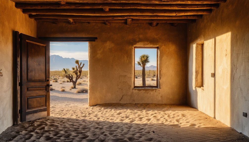
Exploring the Ghost Town Ruins Today

When you explore the decaying ruins of Goldroad, you’ll encounter crumbling mill foundations and deteriorating water tanks that illustrate the town’s once-thriving mining operations.
The site presents significant safety hazards through unstable structures, exposed mining shafts, and weakened retaining walls that require cautious navigation.
Throughout the canyon landscape, observant visitors can discover partially buried mining artifacts and equipment fragments that offer tangible connections to the area’s industrial past.
Crumbling Mills Reveal History
The crumbling mills of Goldroad stand as silent witnesses to the once-thriving gold mining operations that defined this now-abandoned settlement. As you explore, you’ll encounter rusted machinery parts—large gears and ore cart rails—half-buried in rocky soil, offering insights into early 20th-century mining technology.
These crumbling structures reveal the sophisticated engineering that powered Goldroad’s prosperity. The mining heritage is further evidenced by sealed horizontal adits visible in surrounding hillsides. Though closed for safety, these entrances mark access points to the extensive underground network once used for extraction.
Stone foundations of the company store, post office, and miners’ cabins outline the community’s organization. The assay office ruins stand more substantially, silently narrating the scientific processes that transformed raw ore into wealth.
Dangerous Decaying Infrastructure
Visitors to Goldroad today encounter a landscape fraught with structural hazards that demand extreme caution during exploration. The scattered ruins of miners’ cabins and collapsed boardinghouses present unstable foundations hidden by encroaching vegetation.
You’ll find dangerous structures throughout the site, particularly at the partially collapsed company store and post office where weakened walls, exposed nails, and broken glass create imminent threats.
Mine adits pose additional risks, with sealed entrances potentially hiding unstable backfill while unmarked shafts create ground subsidence hazards.
Rusted machinery parts lie in wait to inflict puncture wounds if disturbed. Safety precautions are essential as no warning signs, barriers, or emergency services exist nearby.
The combination of extreme desert temperatures, wildlife hazards, and crumbling infrastructure makes Goldroad’s remaining structures beautiful yet treacherous historical artifacts.
Hidden Mining Artifacts
Despite their decaying state, Goldroad’s ruins contain a wealth of historically significant mining artifacts that offer glimpses into the town’s prosperous past. As you explore, you’ll discover quartz chunks containing gold—similar to those found by Jose Jerez—that reveal the geological basis for Goldroad’s existence.
The site presents a tangible mining heritage through scattered ore cart rails, massive gears, and mill components partially reclaimed by desert soil.
The remains of the assay office and mine administration buildings mark where precious metals were evaluated. Without formal artifact preservation efforts, these historical treasures face continued environmental degradation.
Foundation stones from miners’ cabins and the collapsed company store tell stories of daily life, while processing equipment demonstrates the technical sophistication that once extracted wealth from Arizona’s hills.
The Goldroad Cemetery: Final Resting Place of Miners
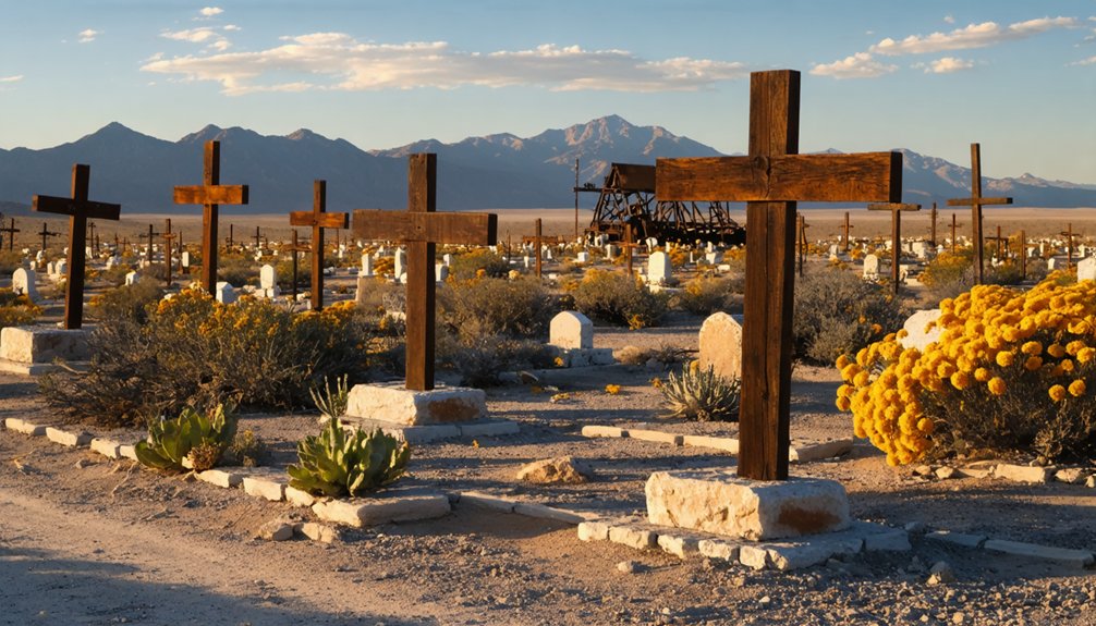
Nestled in a canyon near Sitgreaves Pass along historic Route 66, Goldroad Cemetery stands as a poignant memorial to the mining community that once thrived in this harsh Arizona landscape. Established around 1902, this burial ground offers a glimpse into the social hierarchy and dangerous realities faced by gold miners.
Among the weathered tombstones lies Johnny Ringo’s final resting place, a site that attracts history enthusiasts and curious travelers alike. The infamous cowboy, known for his role in the Gunfight at the O.K. Corral, adds a layer of intrigue to the cemetery’s somber ambiance. As visitors wander through the hallowed grounds, they are reminded of the legends and lives that shaped this rugged region of Arizona.
A silent witness to frontier dreams and tragedies, forever preserved amid the rugged beauty of Arizona’s gold country.
The cemetery’s weathered grave markers, ranging from ornate marble headstones to simple rock cairns, reveal the economic disparities within this frontier society. Its historical significance extends beyond mere documentation of deaths—it’s one of the most intact physical remnants of Goldroad’s story.
- Approximately three dozen visible graves with diverse marker styles
- Masonic symbols on several stones indicating fraternal connections
- Evidence of segregation through a separate burial ground for Mexican and Native American miners
- Graves situated on a gentle slope overlooking the former townsite
- Iron-fenced plots suggesting prosperity among certain residents
Frequently Asked Questions
What Happened to Jose Jerez After Selling His Initial Claim?
Jose Jerez squandered your mining claims’ profits drinking in Henry Lovin’s saloon, returned to work as a laborer at his discovered mine, and tragically ended his legacy impact by committing suicide in 1906.
Were There Any Major Mining Accidents or Disasters at Goldroad?
Devastating deaths documented the dangers of Goldroad’s depths. You’ll find John Cassela’s fatal fall particularly notable, when he plummeted to the 800-level sump. Mining safety was minimal, with accident reports suggesting numerous unreported casualties throughout operations.
What Indigenous Tribes Originally Inhabited the Goldroad Area?
The Mojave people (Pipa Aha Macav) primarily inhabited the area, specifically the Hutto-pah clan. You’ll also find historical connections to the Hualapai Tribe, both sharing profound Native Heritage across this landscape.
Is Metal Detecting or Artifact Collection Allowed at Goldroad Today?
Walking a legal tightrope, you’re prohibited from metal detecting or artifact collection at Goldroad due to stringent artifact preservation policies. Federal and state metal detecting regulations protect historical integrity of this archaeological site.
How Did Prohibition Affect the Social Life in Goldroad?
Prohibition’s impact likely transformed Goldroad’s social gatherings from public venues like the Gold Road Club to private homes or clandestine locations, compounded by the town’s declining mining economy during the 1920s-30s.
References
- https://www.legendsofamerica.com/az-goldroad/
- https://www.cornerstone-environmental.com/publications/item/goldroad-and-the-oatman-mining-district
- https://www.arizonan.com/ghost-towns/goldroad/
- https://www.apcrp.org/GOLDROAD/1000 Goldroad Rev.htm
- https://www.exploratography.com/blog-66/goldroad-amp-sitgreaves-pass-az-rt-66
- https://freepages.history.rootsweb.com/~gtusa/usa/az/goldroad.htm
- https://westernmininghistory.com/towns/arizona/goldroad/
- https://pubs.usgs.gov/bul/0743/report.pdf
- https://www.mindat.org/loc-37290.html
- https://azoffroad.net/oatmangoldroad


