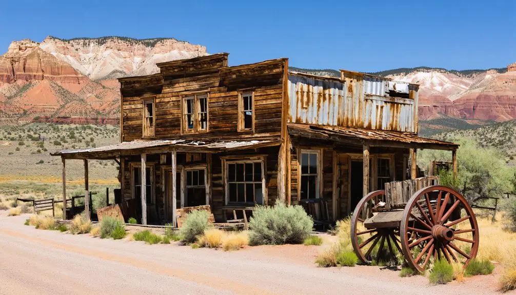
You’ll find Hailstone’s pioneering legacy submerged beneath Utah’s Jordanelle Reservoir. Originally named Elkhorn in 1864, this mining and ranching community thrived until the 1990s when the reservoir’s construction forced its relocation. The town, named after the influential Hailstone family, once bustled with over 300 residents enjoying saloons, concerts, and masquerade balls. Today, drought periods occasionally reveal glimpses of this ghost town’s foundations, hinting at deeper stories beneath the water’s surface.
Key Takeaways
- Hailstone began as a Mormon settlement in 1864, named after the pioneering Hailstone family who established a significant homestead.
- The town flourished through mining, ranching, and logging activities, reaching a population of over 300 residents by 1903.
- Regular social gatherings, dances, and monthly concerts created a vibrant community life during the town’s peak years.
- The entire town was relocated and submerged in 1992 during the construction of Jordanelle Reservoir.
- Historic remnants of Hailstone now lie preserved beneath Jordanelle Reservoir, occasionally visible during drought periods.
The Early Settlement Years
While Mormon colonization of Utah began in 1847, the settlement patterns that would eventually give rise to Hailstone emerged during the broader expansion into southern Utah around 1850.
You’ll find that early settlers faced considerable challenges as they worked to establish viable farmland, manually clearing sagebrush and bunchgrass using oxen, mules, and horses. Following the example of Grafton’s settlers, they initially attempted to grow cotton crops but found limited success.
Like neighboring communities, Hailstone’s development was shaped by the region’s resource-driven settlement approach, following the example of nearby iron towns and agricultural outposts. The discovery of rich iron ore deposits near Cedar City in 1868 influenced settlement patterns throughout southern Utah.
Settler challenges included persistent flooding, occasional conflicts with Southern Paiute peoples, and crop failures that tested their resolve.
Despite these obstacles, the mainly Mormon settlers maintained a communal spirit, implementing agricultural practices that would transform raw frontier land into an organized settlement, though they’d soon face the same viability issues that plagued other regional towns.
From Elkhorn to Hailstone: A Name’s Evolution
The original name of Elkhorn reflected the untamed wilderness that early settlers encountered in this corner of Utah.
Elkhorn’s original name painted a vivid picture of the wild frontier pioneers found in Utah’s untouched landscapes.
You’ll find the name significance deeply rooted in the area’s wildlife and geographic features that greeted pioneers in 1864.
When the Hailstone family established their homestead, they didn’t just settle the land – they shaped its future identity.
Much like how severe thunderstorms can dramatically transform landscapes, the arrival of William Paret and Ann Davis Hailstone permanently altered the character of this Utah settlement.
The homestead became a hub for mining and ranching activities that helped establish the area’s early economic foundation.
William Paret and Ann Davis Hailstone’s influence grew so profound that the community officially changed its name to honor their legacy.
This change from Elkhorn to Hailstone marked a pivotal shift in the settlement’s character, moving from a description of natural features to a celebration of pioneer achievement.
The community legacy of the Hailstone name persisted until the town’s submersion in 1995, and continues to resonate in historical records today.
Mining, Ranching, and Logging Life
Mining dominated Hailstone’s economic landscape, with silver leading the extraction efforts alongside deposits of gold, copper, and zinc.
Like the town of Terrace in 1902, Hailstone eventually succumbed to water supply challenges. You’ll find evidence of advanced mining techniques in the geared wheels and sifters used for ore processing, while the introduction of cyanide processing in 1890 revolutionized how miners extracted value from both old tailings and new deposits. The lack of natural water sources meant that water was trucked in for all mining and residential needs.
The town’s diverse community dynamics centered around three primary industries:
- Mining operations that attracted up to 2,000 residents during the 1873 boom
- Local ranching activities that supported the population’s food needs, though less documented
- Logging efforts that provided essential timber for mine shaft construction and building infrastructure
The town’s fate intertwined with these industries, particularly when the open-pit mine’s collapse brought operations to an abrupt halt, fundamentally altering the community’s composition.
The Community’s Daily Activities
Despite their rugged frontier existence, Hailstone’s residents maintained vibrant social lives centered around communal gathering spots like saloons and general stores.
You’d find townsfolk congregating daily at these social hubs, sharing news and strengthening community bonds through casual interactions. With over 300 people by 1903, the town’s social spaces were constantly buzzing with activity. When special occasions arose, the town came alive with dances, masquerade balls, and holiday celebrations like Thanksgiving.
Much like in Saro Gordo’s American Hotel, the community enjoyed monthly concerts that brought everyone together for entertainment.
Daily life revolved around essential tasks – maintaining stone and wood homes, preparing meals, and tending to children.
While the town lacked formal religious institutions, you’d witness how the community adapted through informal gatherings and celebrations.
Communication with the outside world depended on stagecoach services, which brought mail, supplies, and visitors, helping to break the isolation of frontier living.
Impact of Modern Development
When you explore Hailstone’s modern development history, you’ll find the construction of the Jordanelle Reservoir fundamentally altered the town’s trajectory in the 1990s.
You’ll discover that before the reservoir’s waters submerged portions of the original settlement, residents were required to relocate their homes and businesses to higher ground.
Today, the area attracts many tourists seeking access to the boat ramp at Cisco, drawing parallels to Hailstone’s own waterfront transformation.
Your understanding of the town’s current layout stems directly from this forced relocation, which scattered the once-cohesive community and left only fragments of the original townsite above the waterline.
Similar to the rapid decline seen in mining towns like Frisco, Hailstone’s transformation into its current state happened within a relatively short timeframe.
Reservoir Construction Consequences
The completion of Jordanelle Dam in 1992 brought dramatic changes to Utah’s landscape, submerging the historic communities of Hailstone and Keetley beneath its waters.
The reservoir’s impact extended far beyond physical submersion, fundamentally altering the region’s ecological and social fabric while providing essential water resources for Utah’s growing population.
The community displacement created lasting changes that you can still observe today:
- About 72 residents were forced to relocate, leaving behind their farms, ranches, and pioneer-era buildings.
- Local ecosystems underwent dramatic shifts, affecting both aquatic and terrestrial wildlife habitats.
- Traditional economic activities like farming and lumbering gave way to tourism and recreation around the new reservoir.
While the project supported broader regional development, it came at the cost of lost community identity and historical continuity.
Pre-Submersion Town Relocation
Before Jordanelle Reservoir consumed Hailstone’s landscape, local authorities implemented an extensive relocation strategy that forever changed the lives of its residents.
You’ll find that the systematic dismantling of homes and businesses reflected the community’s resilience in the face of unavoidable alteration. The government coordinated land acquisitions and provided compensation, though the displacement challenges extended far beyond monetary concerns.
Families received options to move to nearby established towns or newly developed areas, while officials worked to preserve historically significant structures through relocation or thorough documentation.
Throughout this changeover, you could see how the physical dismantling of Hailstone mirrored the unraveling of decades-old social bonds, as neighbors who’d shared their lives prepared to scatter across different communities.
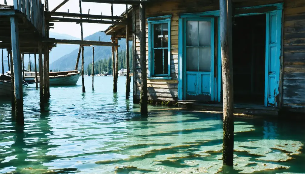
Beneath Jordanelle Reservoir
You’ll find the remnants of Hailstone’s pioneering history resting beneath Jordanelle Reservoir’s waters, following the 1992 dam construction that submerged this once-thriving settlement.
The reservoir’s creation required extensive planning and community displacement, transforming farmlands, ranches, and historic buildings into an underwater landscape that occasionally resurfaces during drought periods.
What lies beneath holds significant archaeological value, including foundations of the original homesteads, railroad infrastructure, and cultural artifacts that tell the story of early Utah settlement patterns.
Reservoir’s Creation and Planning
During the late 1980s, federal planners initiated construction of Jordanelle Reservoir as part of the ambitious Central Utah Project, fundamentally transforming Wasatch County’s landscape.
The reservoir planning faced significant challenges as officials navigated competing interests and environmental impact concerns.
You’ll find the project’s complexity reflected in three key aspects:
- The reservoir aimed to provide critical irrigation water and flood control while incorporating potential hydropower generation.
- Environmental mitigation efforts included creating wetlands at the dam’s base to address conservationist concerns.
- The project sparked intense debate among local geologists, mining interests, and county officials over safety, necessity, and costs.
Despite opposition and geological scrutiny, construction proceeded, marking Utah’s largest water development effort at the time, forever changing the region’s agricultural and mining heritage.
Historic Landmarks Now Submerged
The creation of Jordanelle Reservoir came at a profound historical cost: the complete submersion of Keetley, a once-vibrant Utah town.
You’ll find no visible traces of the community’s submerged structures today, as they rest beneath approximately 13 billion cubic feet of water.
Before its flooding in the mid-1990s, Keetley boasted notable local infrastructure and community buildings of historical significance.
The transformation required extensive changes to the surrounding roadways and highways, permanently altering the landscape.
While historical maps and photographs preserve some documentation of these lost landmarks, you can’t access or study the physical remains without diving.
The town’s submersion represents more than just a geographical change – it’s the physical erasure of a community’s heritage, now preserved primarily through local stories and historical records.
Underwater Archaeological Significance
Beneath Jordanelle Reservoir‘s vast waters lies a complex underwater archaeological environment, where fine-mud deposits and anoxic conditions help preserve Hailstone’s submerged artifacts and structures.
The sedimentary layers create unique preservation conditions that protect important historical evidence of Utah’s past settlement patterns.
You’ll find three key factors contributing to archaeological preservation beneath the reservoir:
- Fine-mud burial promotes protection of wooden and stone artifacts
- Anoxic conditions reduce biological decay processes
- Sediment layers maintain structural integrity of complex ruins
While reservoir fluctuations can threaten submerged artifacts through erosion during drawdowns, the underwater environment generally shields cultural materials from degradation.
Digital reconstruction techniques and underwater remote sensing now allow researchers to study these submerged remains, offering valuable insights into the region’s industrial development and socio-economic transformations.
Historical Documentation and Records
Historical records paint a detailed portrait of Hailstone’s evolution from its 1864 founding as Elkhorn to its ultimate submersion beneath Jordanelle Reservoir in 1995.
You’ll find the town’s local heritage preserved through homestead registries, land records, and census data that document the pioneering spirit of William and Ann Hailstone alongside fellow settlers.
The historical significance of this community emerges through documented economic activities spanning mining, ranching, and logging operations.
Township surveys and cartographic records at 40°36′30″N 111°24′40″W reveal a strategic location at the junction of US-40 and US-189.
Community infrastructure included a school, post office, and store, serving roughly 72 residents before relocation.
During WWII, records note Japanese-American internees leasing agricultural land, adding another layer to Hailstone’s documented history.
Preserving a Submerged History
Since its submersion beneath Jordanelle Reservoir in 1995, preserving Hailstone’s physical remnants has posed unique challenges for historians and conservationists.
The aquatic environment accelerates decay while fluctuating water levels create complex preservation challenges for archaeological techniques.
Modern technology has revolutionized documentation efforts through:
- Aerial drone surveys capturing detailed imagery of exposed foundations
- Digital mapping and photographic archives preserving site layout data
- Non-intrusive research methods adapted for submerged conditions
You’ll find that water damage and sediment cycles have complicated traditional preservation approaches, yet they’ve also preserved certain artifacts in unique ways.
While physical reconstruction isn’t feasible, the site’s documentation serves an essential role in maintaining Utah’s pioneer heritage and demonstrates the environmental trade-offs in regional water management decisions.
Frequently Asked Questions
What Happened to the Residents When Hailstone Was Flooded?
In the blink of an eye, you’d have seen residents pack up and move to Park City and Heber City as Hailstone’s history ended with a planned flood impact, preserving key buildings elsewhere.
Are There Any Remnants of Hailstone Visible During Low Water Levels?
You’ll find ghost town remnants like building foundations and old roadbeds when water levels drop. These underwater artifacts, including mining and ranching structures, briefly emerge during reservoir drawdowns.
How Many People Lived in Hailstone at Its Peak Population?
Like footprints in shifting sand, Hailstone’s peak population remains elusive in history’s records. You won’t find exact numbers, though experts believe it was smaller than comparable Utah ghost towns reaching 150 residents.
This mystery adds to the overall intrigue surrounding the history of Hale, Utah ghost town. Local legends tell of the last days of its inhabitants, who left behind whispers of untold stories and forgotten dreams. Today, the remnants of Hale stand as a silent testament to the passage of time and the fading echoes of its once vibrant community.
Was There Any Opposition to the Jordanelle Reservoir Construction Plan?
You’ll find extensive opposition faced the reservoir construction, from environmental groups, Ute tribes, mining interests, and local communities who challenged geological safety, water rights, endangered species, and economic impacts.
What Native American Tribes Originally Inhabited the Hailstone Area?
Like ancient guardians of the mountains, you’ll find the Ute Tribes were the primary inhabitants of Hailstone’s land, while the Shoshone Culture shared some overlapping territories in the broader region.
References
- https://www.deseret.com/utah/2024/06/03/how-to-visit-utah-ghost-towns/
- https://www.valleyjournals.com/2024/10/02/507818/exploring-utah-s-ghost-towns-seven-abandoned-settlements-with-fascinating-histories
- https://graftonheritage.org/history-settlement/
- https://en.wikipedia.org/wiki/Hailstone
- https://www.historynet.com/ghost-town-silver-reef-utah/
- https://www.youtube.com/watch?v=AoiIha-3iNo
- https://www.uen.org/utah_history_encyclopedia/c/COLONIZATION_OF_UTAH.shtml
- https://www.boxeldercountyut.gov/523/Blue-Creek-History
- https://www.wikiwand.com/en/articles/Hailstone
- https://onlineutah.us/hailstonehistory.shtml


