You’ll find Kentucky’s haunted ghost towns scattered across former coal mining regions, where settlements like Blue Heron Mine 18 and Barthell preserve the skeletal remains of company towns abandoned in the mid-20th century. These sites, established by operations like Stearns Coal and Lumber Company, now feature reconstructed structures and audio testimonies from former residents. Scuffletown, a Cherokee settlement from 1800, vanished beneath Ohio River floods in 1913 and 1937, while Golden Pond disappeared under TVA lake waters in 1970. The stories behind these communities reveal Kentucky’s complex industrial and cultural heritage.
Key Takeaways
- Blue Heron Mine 18 features audio stations sharing former residents’ stories amid ghost-like metal shell structures in McCreary County.
- Golden Pond residents report phantom lights beneath the lake where the town was submerged by TVA between 1964–1970.
- Barthell Mining Camp was abandoned after a 1943 fire, remaining deserted until preservation efforts began in 1999.
- Scuffletown, devastated by 1913 and 1937 floods, left only wetlands and remnants of its Native American settlement heritage.
- Packard in Whitley County closed in 1946, leaving only crumbling foundations marking the former coal mining community.
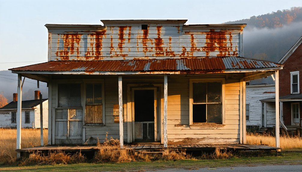
Barthell: The Preserved Mining Camp Frozen in Time
When the Stearns Coal and Lumber Company established Barthell in 1902, it became the first of eighteen mining camps that would eventually dot McCreary County’s landscape.
You’ll find this reconstructed settlement showcases authentic mining heritage through twelve restored miner’s houses, a company store, and schoolhouse.
The camp reached peak production in January 1930 with 100,961 tons of coal extracted.
A devastating 1943 fire destroyed the tipple, effectively ending operations at Mine One.
The site sat abandoned until 1999 when Harold “Sonny” Koger invested over $500,000 in historical preservation efforts.
Today, you can walk through this open-air museum and examine antique cars from 1909-1934, experiencing firsthand how coal miners lived and worked during the early twentieth century.
The camp was named after E.E. Barthell, a Nashville lawyer who served as the company’s general counsel.
The mining operations began under L.E. Bryant’s supervision, who had previously attracted major investors by displaying a massive coal block at the 1893 Chicago Columbian Exhibition.
Blue Heron Mine 18: Ghost Structures Along the Big South Fork
You’ll find Blue Heron Mine 18 nestled along the Big South Fork River, where it operated under Stearns Coal and Lumber Company from 1937 until closing in December 1962 due to unprofitability.
The National Park Service recreated the site in the 1980s as an open-air ghost structure museum within Big South Fork National River and Recreation Area.
Open metal shells now stand where original buildings once housed this isolated coal community, replicating the railroad depot, coal tipple, school, and residences to their original dimensions and locations. Audio buttons at each structure allow visitors to hear stories from former residents who once lived and worked in this remote mining town. The name “Blue Heron” itself refers to multiple historical interpretations, including the native waterfowl spotted along the river and various local landmarks that shared this common designation.
Abandoned Coal Mining Operations
After Justus Stearns purchased 30,000 acres in 1899, the Stearns Coal & Lumber Company emerged in 1902 to exploit Kentucky’s rich coal deposits along the Big South Fork.
Mine 18 opened in 1937, operating until December 1962 when depleted coal seams forced closure.
You’ll find miners once earned less than 60 cents per ton, hand-loading up to 15 tons daily in 32-inch seams.
The high-sulfur #2 coal proved unprofitable without proper core drilling.
Operations ceased when resources played out, leaving buildings to decay.
Stearns sold remaining mines to Blue Diamond Coal Co. in 1976, which ceased operations by 1987.
Environmental impacts from abandoned sites prompted reclaiming efforts, transforming Mine 18 into an interpretive outdoor museum during the 1980s with metal shell replicas marking original structures.
The mine featured five openings capable of processing coal from multiple locations and handling various grades of the resource.
Ghost Structure Museum Display
The National Park Service transformed Mine 18 into an innovative outdoor museum during the 1980s by constructing open metal shells that replicate the mining camp’s original buildings. You’ll discover steel frames marking where structures once stood—the company store, schoolhouse, coal tipple, and workers’ residences—all built to their original dimensions and orientations.
Each ghost structure features button-activated audio stations where former residents share firsthand accounts of life at Mine 18. You’ll hear stories about courtship, family life, and daily routines as you follow the self-guided paved path through this open air museum. The depot serves as the starting point for tours, displaying models of the town as it appeared during the 1950s.
The interpretive center opened in 1989, bringing these metal skeletons to life through photographs and oral histories. Since no complete written records survived the mine’s 1962 closure, these personal testimonies preserve the camp’s authentic legacy.
Big South Fork Location
Nestled along the banks of the Big South Fork River in McCreary County, Kentucky, Mine 18 occupies one of the Cumberland Plateau’s most remote industrial sites. The coordinates 36°40′17″N 84°32′44″W place you deep within territory where geological formations yielded profitable coal seams for decades.
Justus Stearns acquired this rugged landscape in 1899, recognizing its mineral wealth beneath ancient rock layers.
The site’s isolation defined its character:
- Accessible only via Kentucky & Tennessee Railroad through wilderness
- Underground tunnels extended through plateau bedrock following coal veins
- Electric tram system transported ore along both riverbanks
- Slope mine entrance carved directly into geological formations
- Company town housed hundreds of workers miles from civilization
Today’s Big South Fork National River and Recreation Area preserves this ghost camp’s haunting legacy. The surrounding landscape features natural bridges and gorges carved by centuries of erosion across the Cumberland Plateau.
Scuffletown: Cherokee Settlement Lost to Devastating Floods
You’ll find Scuffletown’s origins around 1800, when Jonathan Thomas Stott—a full-blood Shawnee—and his Cherokee wife Mary Polly Cooper established a tavern and trading post that attracted rowdy flatboatmen along the Ohio River.
The settlement survived Stott’s violent death in 1838 and even served as a strategic Civil War outpost with Union troops and gunboats patrolling its waters. The community’s tobacco-processing operation exported 400 to 450 hogsheads annually to Europe for pipe tobacco and snuff, contributing significantly to the regional economy. After Stand Watie’s death in 1871, Chief James Martin led Southern Cherokee refugees from persecution in Indian Territory to reestablish their government in Henderson, Kentucky, where Governor John Young Brown officially recognized the tribe in 1893.
The catastrophic floods of 1913 and 1937 ultimately devastated the community beyond recovery, leaving behind only deserted wetlands where Southern Cherokee descendants once thrived for over a century.
Early Cherokee-Shawnee Founders
Around 1800, Jonathan Thomas Stott—a full-blood Shawnee also known as Scott or Fox—and Mary Polly Cooper, a full-blood Cherokee, founded Scuffletown along the Ohio River in what would become Henderson County.
This Native history represents a unique intersection of two tribal nations establishing autonomous community roots.
The settlement origins reveal significant details:
- Jonathan and Mary had two sons: Jonathan and Thomas.
- Cherokee already resided permanently in Wayne, Pulaski, and McCreary Counties before Scuffletown’s establishment.
- The Cumberland and Ohio Rivers formed accepted territorial boundaries between Shawnee and Cherokee nations.
- Jonathan Thomas Stott died around 1838 during a brawl in Shawneetown, Illinois.
- Their descendant, Thomas “Silver Fox” Scott, later became the third Chief of the Southern Cherokee Nation.
The name Scuffletown itself echoed an earlier settlement pattern, as militia encampments near Knoxville were similarly called “Scuffletown” due to soldier wrestling activities in the 1790s.
This founding established Kentucky’s most distinctive Native settlement.
Scott’s Tavern and Trade
By 1800, Jonathan Thomas Scott—known alternately as Scott Fox—had established a tavern at a prime Ohio River landing just above the Green River’s mouth. This strategic location became essential for river commerce, serving flatboat crews guiding downstream.
Scott’s establishment dispensed liquor freely, and the inevitable result was constant fighting among rivermen. These alcohol-fueled brawls gave birth to community legends and earned the settlement its enduring name: Scuffletown.
The tavern operated from 1800 to 1804 as a critical waypoint for river traffic.
You’ll find it marked the beginning of permanent settlement at this bend in the Ohio. What started as a rough drinking establishment became the foundation for a community that would attract additional settlers like Eneas McCallister Jr., who arrived in 1809.
Twin Floods Sealed Fate
Although Scuffletown survived more than a century of river commerce and territorial conflicts, the settlement couldn’t withstand nature’s overwhelming force.
Flood aftermath transformed this thriving Cherokee community:
- The 1913 Great Flood devastated the city, triggering immediate mass exodus from the Green River settlement.
- Post office operations ceased permanently in 1914, marking official settlement decline.
- The 1937 flood decimated remaining structures and scattered the last residents.
- Vast real estate areas became inexplicably deserted, never recovering their population.
- Southern Cherokee descendants still inhabit Green River today, maintaining ancestral connections.
You’ll find proposals for protected wetland and national wildlife refuge have circulated for decades across this flood-prone landscape.
The twin disasters sealed Scuffletown’s fate as Kentucky’s most significant lost Cherokee settlement, where nature reclaimed what river commerce once built.
Packard: The Forgotten Coal Town of Whitley County
Deep in the Cumberland Mountains of Whitley County, approximately seven miles southeast of Williamsburg, the Thomas B. Mahan family established a mining camp around 1900, naming it after schoolteacher Mary Amelia Packard.
You’ll find mining legends here intertwined with harsh realities—three coal companies employed up to 250 workers who lived trapped by company scrip, redeemable only at inflated-price stores.
The labor struggles of 1922 required Governor Morrow’s National Guard intervention, complete with machine gun squads, when miners struck over cash-less wages. Though unionization brought temporary improvements, workers remained economically subjugated until Mahan Jellico Coal Company ceased operations in 1946.
Today, you can glimpse crumbling foundations from afar on restricted private property—all that remains of this forgotten town where 400 residents once lived.
Golden Pond: Moonshiner’s Haven Claimed by the Lake

When postal records first documented Golden Pond on December 28, 1848, they marked the beginning of what would become the capital of Kentucky’s between-the-rivers region. European settlers officially established the town in 1882, naming it for a pond reflecting golden sunlight 2.25 miles west.
Golden Pond emerged from postal records in 1848, named for sunlit waters that would define Kentucky’s between-the-rivers capital for generations.
During Prohibition (1920-1933), moonshine legends flourished as distillers operated hidden stills throughout the timbered hills. Al Capone himself favored Golden Pond’s high-quality product, secretly shipped to Chicago, Detroit, and St. Louis.
The town survived:
- Devastating fires in 1898 and 1936
- Supporting dozen businesses through town revival periods
- 120 years of postal service until 1968
- TVA’s forced evacuation (1964-1970)
- Submersion beneath the lake
Today, only two concrete mounting blocks remain downtown, though visitors report phantom lights glowing beneath the water’s surface.
Bells Mines: Cemetery in the Wilderness
While Golden Pond vanished beneath rising waters, Bells Mines met a different fate—abandoned to the encroaching wilderness of Crittenden County. John Bell established this coal mining settlement in 1842, attracting workers from England, Germany, France, and Ireland throughout the 1800s.
The community survived a Civil War battle in 1864 when 46 Union soldiers fought 300 Confederate guerrillas, but couldn’t withstand Alcoa’s 1950s land purchase of nearly 12,000 acres. Families sold their homes expecting a promised factory that never came.
Today, Bells Mines Cemetery stands as the sole remnant—a symbol of historical preservation amid advancing forest. Simple slabs and ornate marble monuments mark generations of miners and their families.
Urban legends and ghost rumors now surround this isolated graveyard, transforming cemetery legends into the town’s final chapter.
Spirits of the Mines: Tales From Kentucky’s Coal Country
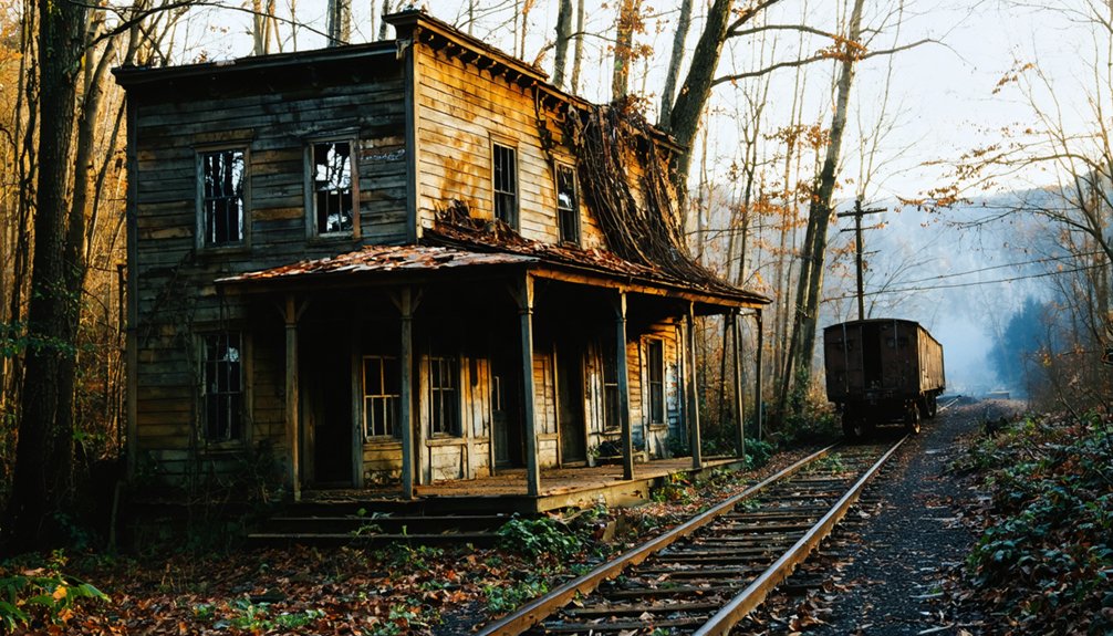
Kentucky’s coal mining industry carved deep scars into the landscape between the 1820s and late twentieth century, leaving behind abandoned settlements that now fuel ghost stories across the commonwealth. Paradise, Lynch, Blue Heron, Empire, Packard, and Barthell stand as testaments to boom-and-bust cycles that displaced thousands.
Spiritual legends emerged from these ruins, with haunting sightings reported where miners once worked.
Notable Coal Town Remnants:
- Paradise – TVA bought out 800 residents by December 1967; only cemetery remains near fossil plant
- Lynch – Founded 1917, peaked before 1940s producing 12,820 tons in nine hours (1923)
- Blue Heron – Mine 18 operated 1937-1962; ghost structures re-created at 1989 interpretive center
- Barthell – Restored company houses preserve shoulder-to-shoulder camp layout
- Empire/Packard – Mid-twentieth century collapse left industrial remnants
Visiting Kentucky’s Abandoned Towns: What Remains Today
Though decades have passed since residents abandoned these settlements, Kentucky’s ghost towns preserve tangible evidence of communities erased by industrial collapse and government intervention.
the allure of exploring abandoned buildings in Kentucky draws urban explorers and history enthusiasts alike. Each structure holds stories of the past, making them fascinating sites for photography and adventure. As visitors wander through crumbling walls and overgrown grounds, they connect with the remnants of lives once lived.
You’ll find Paradise reduced to hilltop cemeteries after TVA buyouts deliberately cleared the land.
Blue Heron Mining Camp offers crumbling structures and rusting equipment within Big South Fork’s boundaries, while Lynch and Kyrock display haunting coal-era ruins.
Historical preservation efforts at Barthell Coal Camp maintain restored company houses in original patterns, contrasting with Six Gun City‘s eerie abandoned amusement park buildings.
Urban legends surround Waverly Hills Sanatorium‘s “Body Chute” and Eastern State Hospital’s decaying patient wards.
Camp Nelson’s Civil War structures stand as designated monuments, and Airdrie‘s iron furnace rises through reclaimed forest, documenting Kentucky’s vanished industrial heritage.
Frequently Asked Questions
Are Overnight Stays Still Available at the Renovated Homes in Barthell?
No, you can’t stay overnight—the renovated homes remain frozen in time, closed for construction since their latest updates. Historical preservation continues while local legends linger. Check barthellcoalcamp.com or call 888-550-5748 for reopening information.
What Safety Precautions Should Visitors Take When Exploring These Ghost Towns?
You’ll need essential safety gear including sturdy boots, flashlights, and first-aid supplies for urban exploration. Travel with experienced companions, avoid unstable structures, watch for environmental hazards like mine shafts, and always inform someone of your location beforehand.
Can You Visit the Cemetery at Bells Mines Year-Round?
You can visit Bells Mines Cemetery year-round within Big Rivers Wildlife Management Area, which opened publicly in 2013. The site’s historical preservation and cultural significance remain accessible, though you’ll follow wildlife management regulations during your visit.
Are There Guided Tours Available at Blue Heron Mine 18?
No guided underground tours exist—you’ll explore Blue Heron’s historic legends independently via self-guided paved trails. The mine entrance remains sealed, but audio exhibits and interpretive signs document authentic miner voices, letting you discover this coal camp’s story at your own pace.
What Artifacts or Structures Remain Visible at Golden Pond Today?
You’ll find two concrete mounting blocks from the 1800s along the former main street. The Golden Pond Visitors Center displays historical photos, family names, and town layouts. Unlike ancient tools or hidden markings, these structures openly document the community’s past.
References
- https://www.onlyinyourstate.com/experiences/kentucky/12-ghost-towns-in-ky
- https://kyforky.com/blogs/journal/haunted-places
- https://www.kentuckybb.com/Blog/Get-Haunted-and-Go-Ghost-Hunting-in-Kentucky.html
- https://www.youtube.com/watch?v=D9gOmfCuKLs
- https://en.wikipedia.org/wiki/List_of_ghost_towns_in_Kentucky
- https://everafterinthewoods.com/abandoned-ghost-towns-in-kentucky-that-still-hold-echoes-of-the-past/
- https://www.freakyfoottours.com/us/kentucky/
- https://thedecorologist.com/ghost-town-cave-city-kentucky/
- https://www.youtube.com/watch?v=3kMLESEo6NE
- https://www.barthellcoalcamp.com/history/timeline.htm