You’ll find Nebraska’s haunted reputation stems from over 900 documented abandoned settlements that vanished by the late 1960s, with Cass County’s 1857 platting boom alone creating 27 towns—42% of its 64 ghost communities. Physical evidence includes graded streets, settler-planted trees, and visible foundations marking sites like Steele City (peaked 1890s), Belvidere (established 1870s), and Knox County’s Bazile Mills (founded 1876). These locations preserve atmospheric remnants alongside folklore accounts, while historic railroad maps from 1874-1915 and aerial imagery reveal additional undocumented sites awaiting discovery through archival methods detailed further below.
Key Takeaways
- Over 900 Nebraska settlements vanished by the late 1960s, leaving behind graded streets, foundations, and settler-planted trees with atmospheric significance.
- Steele City preserves structures from its 1890 peak, including a church, blacksmith shop, and museum, making it a notable ghost town destination.
- Isolated grain elevators beside abandoned rail lines mark former communities, serving as skeletal industrial monuments throughout Nebraska’s landscape.
- Historic maps from 1874-1915 and aerial imagery help locate ghost town sites through soil discoloration, vegetation patterns, and structural remnants.
- Brooklyn’s 1857 settlement pattern and Bazile Mills’ water-powered origins exemplify early Nebraska towns that declined due to economic and transportation shifts.
The Rise and Fall of Nebraska’s 900+ Abandoned Settlements
During the late 1960s, researchers conducting an all-encompassing survey of Nebraska’s rural landscape documented a startling discovery: over 900 settlements had been abandoned or reduced to near-extinction across the state.
Over 900 Nebraska settlements vanished or declined to near-extinction by the late 1960s, researchers discovered in a comprehensive rural survey.
You’ll find these weren’t Hollywood-style mining camps but communities that emerged during railroad expansion between 1870-1890, platted by land development companies along river fords and ferry crossings.
Unlike Colorado’s dramatic ghost towns, Nebraska’s urban decay occurred gradually through eroding rural populations.
The late 1930s agricultural collapse accelerated abandonment, while railroad branch closures sealed many towns’ fates.
Factoryville’s flour mill and college couldn’t survive without rail access.
Fort Kearny’s 1871 military closure emptied Dobytown overnight.
Venus Store exemplified community longevity, operating for nearly 100 years from 1879 to 1979 before finally closing.
Researchers relied on county histories and newspapers to piece together location clues for these vanished settlements.
This cultural heritage persists through graded streets, settler-planted trees, and foundations visible in aerial photographs—testament to communities railroads created, then destroyed.
Cass County’s 1857 Platting Boom and Its 64 Lost Communities
When surveyors completed the official sectionization of Cass County in 1856, they unknowingly triggered one of Nebraska Territory’s most aggressive land speculation episodes. Twenty-seven towns were platted during 1857 alone—representing forty-two percent of the county’s eventual sixty-four ghost towns.
Brooklyn’s February 3, 1857 plat exemplified this explosion of early settlement. You’ll find these communities followed Rock Bluff’s standardized town layout: central public squares with lots radiating outward, typically five blocks south and three blocks west.
Samuel Martin’s 1853 trading post below the Platte River’s mouth preceded this boom under War Department permit. By May 1865, approximately 2,360 covered wagons crossed at Plattsmouth, yet most platted communities never achieved permanent occupation—victims of shifting migration patterns and speculative overreach. Transportation development ultimately sealed many communities’ fates when the Missouri Pacific Railway built stations at strategic locations in 1886, causing populations to relocate and businesses to shutter in bypassed settlements. The county’s fifteen towns include several that remain active today, while others joined the ranks of Nebraska’s ghost town landscape.
Knox County’s Vanished Mill Towns and Cemetery Landmarks
Knox County’s mill town settlements emerged from the convergence of water power and agricultural necessity, with Bazile Mills representing the district’s most ambitious industrial venture. Samuel D. Brooks established his flour mill in 1876 at $15,000, leveraging Bazile Creek’s superior water power three miles north of Creighton.
Water power and agricultural necessity converged at Bazile Mills, Samuel D. Brooks’s ambitious $15,000 industrial venture on Bazile Creek.
Meanwhile, Pischelville‘s diversified economy—blacksmith shop (operational until 1954), saw mill, and flour mill—supported agricultural production until abandonment.
The region’s Midwestern folklore intertwines with abandoned architecture at sites like Bohemian National Cemetery’s artistic grave markers and Frankfort‘s 1856 settlement, where S. Loeber faced frontier violence (Charles Rohe’s 1857 murder by Rudolph Grasso). Creighton’s Bruce Colony organized the town’s establishment in 1871, with early residents constructing sod houses before the first frame structure. Frankfort’s first school, taught by Mrs. Clark in 1871, established the settlement as a center of civilization for Missouri River pioneers.
Knox County’s Ghost Town Typology:
- Mill-dependent settlements (Bazile Mills, Pischelville)
- Service center communities (Venus, post office closed)
- Contested sites (Mansfield, abandoned 1871)
- Flood-vulnerable bottomlands (Frankfort, Missouri River inundation)
Railroad Expansion Ghost Towns Along Forgotten Rail Lines
You’ll discover Nebraska’s vanished railroad towns by locating isolated grain elevators that stand at odd angles to modern county road grids—physical markers of communities founded during the 1870-1890 railroad expansion peak.
Historic railroad maps compared against current aerial photographs reveal foundations, graded streets, and angled rights-of-way where settlements like Poole (post office 1892-1903) and Vroman (active to 1903) once thrived along Union Pacific sidings.
These grain elevators, oriented to serve rail lines abandoned by the late 1930s following agricultural collapse and branch closures like the Wabash’s 1983 shutdown, remain the most visible identification markers distinguishing railroad ghost towns from other vanished settlements. The Wabash Railroad network, which once spanned over 2,000 miles across the Midwest, connected numerous depot towns that either flourished or eventually disappeared as rail traffic declined. Railroad companies often employed alphabetical naming strategies for new towns, with Belvedere followed by Carlton as sequential stops that served as incentives for railroad officials and their families.
Isolated Grain Elevator Markers
Scattered across Nebraska’s windswept plains, grain elevators stand as skeletal monuments to the railroad boom that once promised prosperity to rural communities. These industrial decay markers reveal the fragility of agricultural economics—Neligh’s 1886 and 1899 structures operated nearly a century before structural failure forced demolition in the early 1980s.
The grain elevator symbolism becomes particularly stark when examining abandonment patterns:
- Scoular’s Superior operation (founded 1892) collapsed after mid-1980s farm bills eliminated grain storage subsidies
- Willow Island’s wooden elevator features rotting cloth sacks and caved-in roofing
- 249 miles of Nebraska rail abandoned since 1963, with 310 miles pending
- Country elevators served 84 sites marketing 39 million bushels in 1970
You’ll find these crumbling sentinels wherever rail connections died, leaving communities stranded. At its peak, the company operated 72 grain elevators across eight states before the federal policy shift triggered widespread closures. Despite their listing in the National Register of Historic Places, preservation costs ranging from $350,000 to $650,000 often exceed available funding, consigning these structures to demolition rather than restoration.
Historic Railroad Map Discovery
These crumbling grain elevators mark endpoints of vanished rail corridors that 19th-century cartographers meticulously documented before abandonment.
You’ll find the 1874 Asher & Adams map labels exact mileage between towns along CB&Q and UP routes, establishing historic mapping standards for Nebraska’s railroad boom.
The 1915 official network map—featuring detailed population indexes—captures peak expansion before decline transformed these settlements into ghost town preservation sites.
Union Pacific’s 1880 land grant map (LC Railroad Maps Collection entry 593, scale 1:1,300,000) charts the corporate infrastructure that birthed rail-dependent communities.
Chicago & North Western’s failed Cowboy Line from Omaha to Lander, Wyoming exemplifies transcontinental ambitions reduced to abandoned agricultural branches—stretches still visible across state right-of-ways today.
Methods for Locating Hidden Town Sites Using Historic Maps

You’ll find that historic railroad maps from Nebraska’s 1870-1890 expansion period precisely document station locations, branch line routes, and platted town sites that county plat books filed with surveyor names and dedication dates confirm.
When you overlay these period maps against modern aerial photography, building foundations invisible at ground level become visible, while graded streets shaded by settler-planted trees reveal former thoroughfares decades after abandonment.
Aerial views expose railroad rights-of-way and grain elevators oriented at angles inconsistent with current county road grids—reliable indicators that mark former town sites surveyed by land development companies.
Railroad Maps Show Routes
When comparing modern topographic maps to railroad atlases from Nebraska’s 1870-1890 expansion era, you’ll pinpoint ghost town locations that have vanished from contemporary records. The Nebraska State Historical Society archives document these settlement patterns through preserved railway cartography, revealing urban legends rooted in actual communities.
Railroad Map Indicators of Ghost Towns:
- Graded street patterns visible on 1870s-1880s railroad surveys mark larger abandoned settlements.
- Isolated grain elevators positioned along angled track alignments identify former depot sites.
- Alphabetically named stops like Belvidere (1870s) and Carlton appear on Nebraska City, Sidney, & Northeastern Railway’s 1878 Hastings-Sidney line.
- Speculative town plats exist only on historic maps with minimal surface traces today.
AbandonedRails.com and American-Rails.com provide digitized cartographic evidence, while folklore narratives surrounding these sites emerge from documented railroad operations through the 1930s agricultural collapse.
Aerial Photography Reveals Foundations
Aerial photography transformed ghost town research in Nebraska during the 1930s, when the U.S. Geological Survey began systematic documentation flights. You’ll discover building foundations invisible at ground level through these overhead perspectives, as soil discoloration and vegetation patterns betray former street grids and roadbeds.
Modern satellite imagery extends this capability, revealing structural remnants that escaped urban development pressures. Foundation patterns appear most clearly during seasonal shifts, when dormant vegetation exposes underlying archaeological features. Railroad rights-of-way trace visible lines through contemporary landscapes, connecting abandoned transportation hubs to disappeared settlements.
You can cross-reference these aerial discoveries with county plat maps and land survey records to verify site locations. This photographic evidence provides documentary proof where oral histories and newspaper archives remain incomplete, offering you unrestricted access to Nebraska’s hidden settlement history.
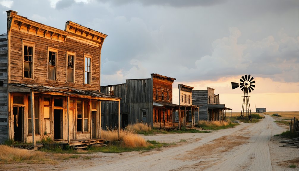
Notable Preserved Examples: Steele City, Belvidere, and Roscoe
Among Nebraska’s most historically significant ghost towns, Steele City stands as the premier preserved example. It was platted in 1873 by Abner Baker and Robert Crinklaw and named for D.M. Steele, president of St. Joe and Western Railway.
You’ll find authentic structures preserved from its 1890 population peak of 380:
- 1882 Baptist Church constructed with Kansas limestone in Romanesque style
- 1902 blacksmith shop restored in the 1980s with working demonstrations
- Turn-of-century bank donated in 1967, restored as living quarters museum
- Original livery barn, schoolhouse, and antique farm machinery displays
Belvidere emerged during the 1870s railroad expansion near the Oregon Trail, though it’s reduced to one-tenth its original size.
Roscoe lacks documented preservation records entirely.
Artistic renderings and folklore legends enhance these sites’ atmospheric appeal for visitors seeking authentic frontier history beyond conventional narratives.
Frequently Asked Questions
Are There Documented Paranormal Activities in Nebraska’s Ghost Towns?
Yes, you’ll find documented paranormal activities including historical hauntings at Fort Sidney Museum (1885 fatal fall) and supernatural legends at Ball Cemetery, where investigators recorded menacing EVPs and captured photographic anomalies during field research.
Which Ghost Towns Allow Public Access Versus Private Property Restrictions?
You’ll find Branched Oak State Recreation Area (Lancaster townsite) welcomes visitors, while most of Nebraska’s 900+ ghost towns involve private property headaches. Access restrictions mean you’re trespassing without permission—historic maps don’t grant you legal entry rights, freedom-seeker.
What Artifacts Can Legally Be Collected From Abandoned Town Sites?
You can’t legally collect artifacts from abandoned town sites without landowner permission. Historical preservation laws (Nebraska Statutes 82-501-510) and legal regulations protect archaeological resources, requiring documented provenance and proper permits for any artifact recovery activities.
Do Any Ghost Towns Offer Guided Tours or Visitor Facilities?
Most Nebraska ghost towns don’t offer facilities, but you’ll find guided tours exploring local legends through Omaha’s haunted sites and Lincoln’s interactive walks, emphasizing historical preservation over authentic abandoned settlements requiring advance booking for paranormal investigations.
For adventurers keen on exploring abandoned towns in Nebraska, there are opportunities to uncover fascinating stories and remnants of the past. Many of these towns showcase unique architecture and history, offering a glimpse into the lives of early settlers. Be sure to pack a camera to capture the eerie beauty of these forgotten places.
While exploring abandoned places in Nebraska, visitors may stumble upon remnants of long-lost homes and storefronts that tell the story of a bygone era. Each location holds its own mysteries, inviting hikers and history buffs alike to delve into the past. Don’t forget to chat with local historians who can provide insights into the intriguing tales behind these deserted sites.
Which Season Is Best for Safely Exploring Nebraska’s Ghost Towns?
Fall (September-October) offers you ideal conditions for exploration, balancing historical preservation access with minimal environmental impacts from Nebraska’s 1870-1890 railroad-era sites, avoiding March-May storms and July-August’s extreme heat documented through 1920-1957 settlement records.
References
- https://history.nebraska.gov/wp-content/uploads/2017/12/doc_publications_NH1937GhostTowns.pdf
- https://negenweb.us/knox/stories/ghosttowns.htm
- https://history.nebraska.gov/finding-nebraskas-ghost-towns/
- https://www.youtube.com/watch?v=l3s2qhSxis8
- https://dawsonpower.com/2020/10/ghost-towns-a-look-at-our-past/
- https://en.wikipedia.org/wiki/List_of_ghost_towns_in_Nebraska
- https://visitnebraska.com/trip-idea/explore-7-authentic-ghost-towns-nebraska
- https://freepages.rootsweb.com/~gtusa/history/usa/ne.htm
- https://everafterinthewoods.com/these-deserted-ghost-towns-in-nebraska-are-full-of-history-and-mystery/
- https://www.geotab.com/ghost-towns/


