You’ll find Vermont’s most haunted ghost town in Glastenbury, where five people vanished between 1945-1950 amid indigenous warnings of a “human eating rock” and cursed boulders. Somerset lies submerged beneath Harriman Reservoir, its logging-camp ruins emerging when water levels drop. Greenbank’s restored covered bridge stands alone after an 1885 fire destroyed the textile mill community. Ricker Basin’s cellar holes dot the mountainside where floods drove residents away, while West Castleton’s quarry ruins hide within Bomoseen State Park, and Lewiston’s depot marks a razed railroad hub—each location preserving stories of mysterious disappearances and spectral sightings throughout Vermont’s wilderness.
Key Takeaways
- Glastenbury features cursed boulders, forest monsters, and an indigenous “human eating rock” legend alongside 1945-1950 disappearances fueling ghost stories.
- Ricker Basin’s cellar holes and mill foundations remain after devastating floods, with persistent local legends of wandering spirits.
- Greenbank’s 1885 mill fire left only foundations and a covered bridge, with haunted tales persisting in the abandoned settlement.
- Somerset lies submerged beneath Harriman Reservoir, revealing eerie ruins like foundations and twisted metal when water levels drop.
- West Castleton and Weston areas feature spectral phenomena including ghostly boats and spirits among Vermont’s haunted settlement legends.
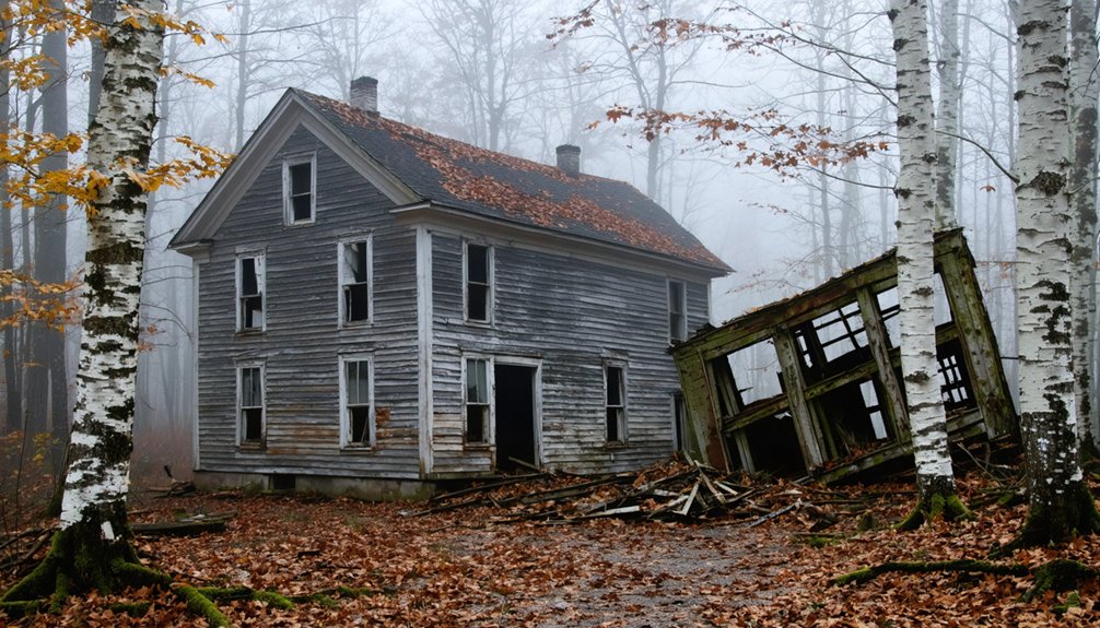
Glastenbury: Vermont’s Most Mysterious Abandoned Settlement
Deep in Vermont’s Green Mountains, the abandoned settlement of Glastenbury stands as one of New England’s most enigmatic ghost towns. Founded by a scheming New Hampshire governor in the early 19th century, this logging community never sustained more than a hundred residents.
Glastenbury: a Vermont ghost town born from political schemes, never thriving beyond a hundred souls in the Green Mountains.
After timber depletion and an 1898 flood destroyed railroad access, the population dwindled to seven by 1937, prompting state disincorporation.
Between 1945 and 1950, five people vanished without trace near Glastenbury Mountain, including hunting guide Middie Rivers and college student Paula Welden.
These disappearances spawned urban legends about cursed boulders and forest monsters. Author Joseph Citro later dubbed the area “The Bennington Triangle,” cementing its reputation for supernatural sightings.
Indigenous tales warned of a “human eating rock,” while colonists reported strange lights and sounds. The town’s earliest days saw only six families residing there in 1791, including George Tibbets, Coffin Wood, and Matthew Fuller, who inhabited this primitive mountain wilderness. However, respected historian Tyler Resch disputes many of these spooky tales, noting that only one documented missing person case can be verified in historical records.
Somerset: The Windham County Logging Town Lost to Time
You’ll find Somerset’s story in southeastern Vermont’s Windham County, where 62 chartered settlers established a remote logging community in 1762 that would peak at 321 residents by the 1880s.
The town served as a strategic beachhead into the southern Green Mountains, with old-growth spruce harvested from Deerfield River valley forests and processed at Mountain Mills—now submerged beneath Harriman Reservoir.
The logging operations extracted staggering quantities of timber through a 41-mile railroad network that connected remote forest areas to Mountain Mills and employed French Canadians, Abenaki, Irish, and other immigrant workers in grueling conditions.
Today, stone foundations and chimneys mark where lumber camps once stood, while the reservoir’s waters occasionally reveal the sawmill ruins that powered this vanished settlement. The town’s final chapter came with the Somerset Dam construction, which began in 1911 and took three years to complete, submerging the remaining structures and marking Somerset’s transformation from thriving community to submerged ghost town.
Somerset’s Lumber Industry Origins
When Mountain Mills emerged in the early 1900s as a bustling logging center, Somerset transformed into the essential beachhead for extracting the southern Green Mountains’ timber wealth.
You’ll find the town’s origins rooted in Vermont’s explosive lumber boom, where timber output skyrocketed from 20 million board feet in 1856 to 375 million by 1889.
Somerset’s strategic importance stemmed from three key advantages:
- River access – Old-growth spruce logs floated down the Deerfield River to Mountain Mills sawmills
- Railroad expansion – 41 miles of track planned by 1906 accessing 300 million feet of timber
- Geographic positioning – Fertile valley land offset agricultural decline while supporting logging operations
The logging operations drew 1,500 workers from diverse regions and backgrounds to construct the infrastructure that would ultimately lead to the town’s demise.
The rapid profit motive drove widespread clearcutting practices throughout the region, with lumber companies showing little interest in replanting efforts.
Unlike Gold mining regions out West, Somerset’s fortune lay in towering trees, making it indispensable to lumber companies seeking unrestricted access to Vermont’s remaining virgin forests.
Strategic Location and Decline
Somerset’s geographic position in Vermont’s southern Green Mountains simultaneously enabled its existence and guaranteed its demise. You’ll find this township arose where ancient trade routes never reached, its mountainous isolation creating opportunity for those willing to extract timber from seemingly worthless land.
The railroad’s 1906 arrival connected 41 miles of logging track to mills, transforming inaccessible wilderness into profitable enterprise.
By the 1880s, 321 residents depended entirely on logging operations. However, ravenous timber demand stripped mountains bare within decades, triggering agricultural decline that no infrastructure could reverse.
French Canadian and Abenaki workers departed as forests vanished.
The 1911 Somerset Dam construction marked the final chapter—reservoir waters submerged what deforestation hadn’t already destroyed, erasing this boom-and-bust settlement completely. Somerset joined neighboring Glastenbury as ghost towns since 1937, their once-thriving logging communities completely abandoned. Vermont’s fragmented forest ownership, with 80% of forests privately held and increasingly divided among smaller parcels, continues to shape logging accessibility and industry viability across the state today.
Preserved Remnants Today
Today’s Harriman Reservoir conceals Somerset’s physical legacy beneath 2,200 acres of water, yet scattered remnants persist along the shoreline and in the submerged zone. When water levels drop, you’ll discover ancient artifacts from the logging era emerging from these submerged landscapes:
- Stone piers and building foundations from sawmills and town structures deteriorate among the ruins
- Six- and eight-inch yellow birch poles mark former logging camp locations throughout the flooded territory
- Ceramic chimney liners and twisted metal bedframes indicate where workers once lived in Somerset’s bustling communities
These physical traces represent Vermont’s extractive industrial history—a testament to the boom-and-bust cycle that transformed wilderness into wealth, then abandoned communities to watery graves nine miles south of modern Somerset. The settlement emerged in the Deerfield River valley, where its position several hundred yards back from the water proved ideal for processing logs that were cut upriver and floated downstream for milling. The town’s origins trace back to September 9, 1761, when Gov. Wentworth chartered the original six-mile-square territory in western Windham County.
Greenbank’s Hollow: Where the Covered Bridge Outlasted the Mill
Deep in the hills of Danville, Vermont, a covered bridge now spans a quiet brook where a bustling industrial hamlet once thrived. Benjamin Greenbank’s textile empire began in 1849, growing into a five-story mill that produced 700 yards of cloth daily and employed 45 workers.
This historical architecture dominated the landscape until December 14, 1885, when flames consumed everything—the mill, bridge, post office, and store. The inferno burned so intensely that residents five miles away in Saint Johnsbury watched the glow.
Greenbank relocated to New Hampshire, and within three years, most residents abandoned the settlement. Today, you’ll find granite foundations and cellar holes marking where homes stood.
Local legends whisper through the restored covered bridge, the sole survivor outlasting Greenbank’s industrial dream.
Lewiston: The Vanished Railroad Community of Windsor County
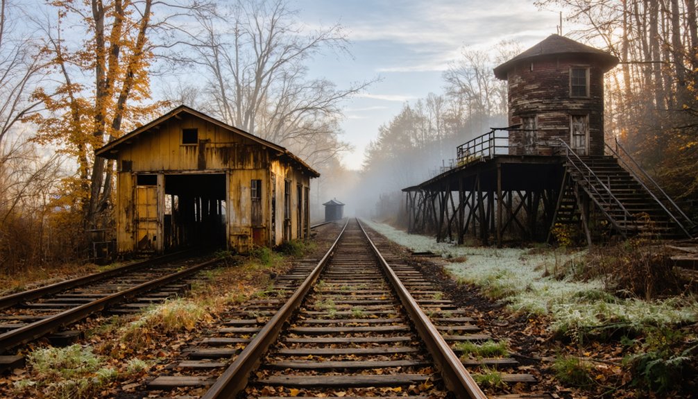
You’ll find Lewiston’s story etched along the Connecticut River’s eastern bank, where a thriving transportation hub emerged in the 1790s connecting Hanover and Norwich. The village reached its zenith after 1848 when the Passumpsic and Connecticut Railroad transformed it into a coal distribution center serving Dartmouth College and the Upper Valley.
Today, you can trace its remnants near Interstate 91’s Exit 13, where Vermont razed nine buildings in 1967, leaving only the 1884 Boston & Maine depot and scattered structures as evidence of two centuries of commerce.
Strategic River Trading Hub
Along the Connecticut River’s Vermont shore, Lewiston emerged in 1765 as a strategic commercial gateway linking New Hampshire’s Hanover with Norwich.
Dr. Lewis established ferry crossings that connected both banks, capitalizing on this natural river passage.
By 1793, he’d acquired mills along Blood Brook, launching the settlement’s industrial foundation.
You’ll find Lewiston exploited three revenue-generating advantages:
- Toll collection from river crossings until the mid-1800s
- Transport hub services for goods destined to Hanover via the 1796 bridge
- Walking-distance access between neighboring commercial centers
The village controlled prime real estate where travelers and freight converged.
Early industries—Burton’s sawmill, tanneries, and bark mills—transformed this crossing point into a thriving commercial node.
Lewiston’s strategic position guaranteed prosperity until transportation patterns shifted away from river-based commerce.
Railroad Town’s Golden Era
When the Passumpsic and Connecticut Railroad laid tracks through Lewiston in 1848, the settlement transformed from a river crossing into a vital transportation nexus.
You’d have witnessed the Boston & Maine Railroad constructing a 24 x 54 foot depot in 1884, featuring Victorian architecture that marked the town’s prosperity.
This railroad architecture became known as Hanover-Norwich Station, serving thousands of Dartmouth freshmen arriving for their education.
Traces Along Connecticut River
Today’s River Road and VT-10A corridor reveal almost nothing of Lewiston’s existence, though this vanished railroad community once thrived along the Connecticut River’s Vermont bank in Windsor County.
You’ll find scant evidence near Ledyard Bridge, where river crossings once brought commerce and settlers to this 1765 township.
Three geographical traces persist:
- Blood Brook’s course – powered Dr. Joseph Lewis’s 1793 grist mill and sawmill operations
- Foley Park area – marks where nine buildings burned in 1967 for Interstate 91
- Narrow flats – between hills and river where Burton’s tannery and bark mill operated
Interstate 91’s Exit 13 construction obliterated structures valued at $377,000, transforming this Upper Valley transportation hub into Windsor County’s most documented ghost town.
The Connecticut River flows past emptied land where rail commerce once sustained an entire community.
Ricker Basin: Hidden Remnants on Ricker Mountain
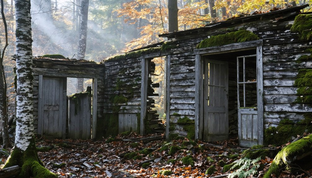
Deep within Little River State Park, the scattered remnants of Ricker Basin tell the story of a 19th-century mountain community that once thrived against formidable odds. Joseph Ricker established this settlement in 1816, where fifty families eventually cleared 4,000 acres of rocky terrain.
Against Vermont’s unforgiving slopes, Joseph Ricker’s 1816 settlement grew into a thriving community of fifty determined families carving civilization from wilderness.
Three sawmills powered by mountain streams drove the economy, supplemented by farms struggling against steep slopes and stubborn soil.
The devastating 1927 flood sealed Ricker Basin’s fate. Winooski River waters rose thirteen feet, destroying homes and isolating survivors.
The 1934 flood finished what nature started, and Waterbury Dam‘s completion in 1938 submerged remaining structures.
Today, you’ll find cellar holes, mill foundations, and the ramshackle Almeran Goodell farmhouse—historic architecture that local legends claim harbors restless spirits of those who refused to abandon their mountain home.
West Castleton: The Ghost Town Within Bomoseen State Park
Between Glen Lake and Lake Bomoseen‘s shores, the vanished village of West Castleton once housed over 300 workers who extracted Vermont’s “gray gold” from Cedar Mountain’s depths. This slate-quarrying settlement thrived from 1850 until the 1929 crash destroyed demand for premium roofing materials.
Today’s Bomoseen State Park preserves these industrial ruins across 600 acres. You’ll discover:
- Cellar holes and quarry gables hidden among maple saplings and goldenrods
- The Slate History Trail leading through abandoned mill sites
- West Castleton Public School No. 9’s foundation marking the community center
Local legends persist about three Irish workers who rowed to a distant tavern and vanished. Their empty boat drifted back at dawn, bodies never recovered.
On full-moon nights, witnesses report a phantom rowboat gliding silently across the water—a spectral echo of this forgotten industrial town.
Frequently Asked Questions
Are Overnight Camping Trips Allowed Near Vermont’s Abandoned Ghost Towns?
Vermont’s abandoned settlements lack designated camping areas, but you’ll find primitive camping on nearby Green Mountain National Forest lands. You’re free to pursue night photography while respecting historic preservation laws—always verify current land ownership and obtain necessary permissions beforehand.
What Safety Precautions Should Visitors Take When Exploring These Ghost Towns?
Vermont’s 300+ abandoned settlements demand respect. You’ll need sturdy footwear, structural awareness, and permission from landowners. Preservation efforts protect these sites’ historical significance—document responsibly, avoid destabilizing ruins, travel with companions, and always inform someone of your exploration plans beforehand.
Can You Legally Remove Artifacts or Items From Vermont Ghost Towns?
No, you can’t legally remove artifacts from Vermont ghost towns. Legal considerations prohibit artifact removal from these sites, as it destroys historical evidence. You’ll face criminal charges regardless of land ownership—take only photographs, leave everything untouched.
Which Ghost Town Is Easiest to Access for Families With Children?
“Easy does it” applies perfectly here—Greenbank’s Hollow offers families the simplest access. You’ll discover ghost town history via a covered bridge and flat mill ruins, where folklore legends meet documented archival sources without challenging hikes restricting your exploration freedom.
Are There Guided Tours Available for Vermont’s Haunted Ghost Towns?
You won’t find formal guided tours at Vermont’s haunted ghost towns. These sites offer self-guided exploration where you’ll discover historical significance through stone foundations and cellar holes, while urban legends remain part of local folklore you can research independently.
References
- https://en.wikipedia.org/wiki/List_of_ghost_towns_in_Vermont
- https://kids.kiddle.co/List_of_ghost_towns_in_Vermont
- https://www.youtube.com/watch?v=2fvPo9iQC-w
- http://freepages.rootsweb.com/~gtusa/history/usa/vt.htm
- https://thecuriousadventuresofkat.wordpress.com/2017/11/09/haunted-vermont/
- https://myfamilytravels.com/supposedly-boring-vermont-towns-hiding-some-truly-strange-landmarks
- https://obscurevermont.com/tag/ruins/
- http://www.onlyinyourstate.com/experiences/vermont/ghost-town-vt
- https://happyvermont.com/2014/10/23/glastenbury-ghost-town/
- https://anna-kasper.com/2025/10/29/my-fuller-ancestors-one-of-six-families-in-glastenbury-vermont-52-ancestors-week-44-rural/


