America’s agricultural ghost towns include Monowi, Nebraska (population: 1), toxic Picher, Oklahoma, and coal-dependent Thurmond, West Virginia. You’ll find Route 66’s forgotten Glenrio straddling Texas and New Mexico, Dust Bowl casualty Center Point in Kansas, and Dearfield, Colorado’s abandoned African-American farming colony. In North Dakota, Hildebran’s empty streets whisper tales of wheat farming dreams. These haunting landscapes reveal how environmental disasters, economic shifts, and transportation changes transformed thriving communities into silent memorials.
Key Takeaways
- Monowi, Nebraska represents extreme rural decline with only one resident maintaining the town’s tavern and 5,000-book library.
- Picher, Oklahoma transformed from agriculture to lead mining, resulting in toxic soil, contaminated water, and eventual forced evacuation.
- Thurmond, West Virginia exemplifies agricultural-industrial collapse, once processing more coal tonnage than major cities.
- Glenrio, Texas/New Mexico illustrates how transportation shifts destroyed agricultural communities when Interstate 40 bypassed Route 66.
- Dearfield, Colorado began as an African-American agricultural colony that thrived during WWI before succumbing to Dust Bowl devastation.
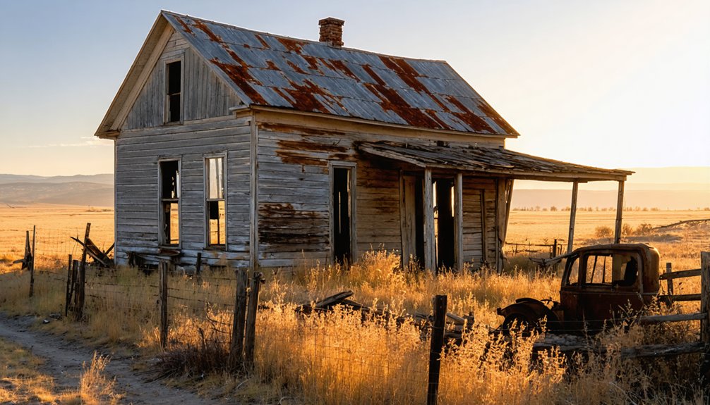
Monowi, Nebraska: America’s One-Person Prairie Town
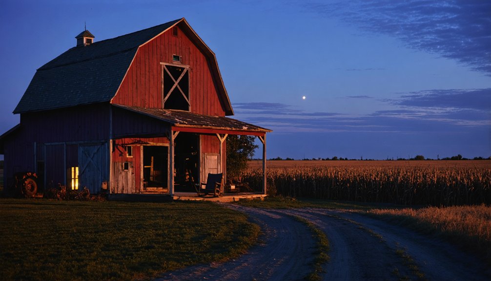
As you journey through the windswept grasslands of northeastern Nebraska, you’ll encounter Monowi, a haunting symbol of the rise and fall of America’s agricultural frontier. This incorporated village, named after a Native American word for “flower,” embodies the stark reality of rural exodus.
Founded in 1902 alongside railroad expansion, Monowi peaked at 150 residents in the 1930s before gradually emptying as younger generations sought opportunities elsewhere.
Today, Elsie Eiler stands as the sole guardian of this place—mayor, tax collector, and proprietor of the Monowi tavern that draws curious visitors worldwide. Her beloved Rudy’s Library houses over 5,000 books in an honor-system arrangement for visitors to explore.
Around her, remnants of community life persist: an abandoned schoolhouse, a church structure, and a library preserving local memory.
This one-person prairie town offers profound historical significance as America’s least populous municipality, silently documenting the transformation of the agricultural landscape. Despite covering 0.212 square miles of Nebraska terrain, Monowi’s population has remained stable at just two residents since 2020.
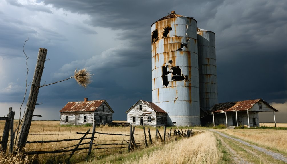
Picher, Oklahoma: From Agricultural Hub to Toxic Ghost Town
If you travel through Picher today, you’ll see toxic chat piles towering where corn and wheat fields once flourished before the agricultural land’s transformation into America’s most productive lead mining district.
What began as a farming community in the early 1900s quickly pivoted to industrial mining that ultimately poisoned the soil, water, and residents with catastrophic levels of lead and zinc contamination. The thriving town reached its peak with over 14,000 residents in 1926 during the height of mining operations.
The abandoned buildings and orange-tinted streams now stand as stark reminders of how industrial priorities destroyed an entire ecosystem and community, forcing the government to permanently evacuate what was once Oklahoma’s most prosperous agricultural-turned-mining town. Children’s health suffered tremendously as evidenced by the orange-colored hair that became common among the young residents exposed to the toxins.
Farming Boom to Bust
While Picher, Oklahoma may seem an unusual entry in a list of agricultural ghost towns, its transformation from thriving mining center to toxic wasteland illustrates the interconnected fate of extractive industries and farming communities throughout America’s heartland.
As you explore Picher’s remains, you’ll witness how mining legacy strangled agricultural potential. The Superfund Site designation in 1983 confirmed the severity of environmental damage that continues to this day.
Farming challenges emerged from:
- Lead-contaminated soil rendering land unusable for crops
- Toxic chat piles leaching chemicals into groundwater
- Acid-polluted Tar Creek destroying water resources for irrigation
- Land restrictions from mining claims limiting agricultural expansion
The town was officially evacuated after a 2006 federal study identified numerous structures at risk of collapse due to the extensive undermining of the area during its mining heyday.
Lead Mining’s Fatal Shift
The town of Picher, Oklahoma stands as a haunting monument to America’s rapid industrial transformation, where one small drill hole in 1913 forever altered the region’s agricultural trajectory.
As you walk through this former boomtown, you’re surrounded by the remnants of a once-thriving mining legacy. Within the city limits, 14,000 shafts once extracted ore worth over $20 billion, supplying more than half the lead and zinc used in World War I.
When mining ceased in 1967, Picher’s economic pulse stopped with it. The town that once dominated the industry with Picher Lead Company ownership gradually faded into obscurity.
The toxic aftermath speaks through orange-stained waterways where acid mine drainage seeps from abandoned tunnels. Children who played in contaminated soil faced devastating neurological damage. A significant 2006 report confirmed these health risks, showing alarming lead poisoning rates among local children.
Environmental Disaster Legacy
Picher’s brief agricultural chapter reads like a desperate epilogue to its mining saga.
You can still see the ghosts of failed farms where toxic chat piles loom over abandoned fields—a permanent environmental impact etched into the landscape.
When the EPA designated Picher as part of the Tar Creek Superfund Site in 1979, they uncovered a toxic legacy that couldn’t be outrun:
- 34% of children suffered from elevated lead levels
- Groundwater contamination rendered wells unusable
- Acidic mine water turned creeks orange with poisonous metals
- Soil toxicity made crop cultivation virtually impossible
The once-thriving community that produced over $20 billion worth of ore became a cautionary tale of environmental devastation.
Thurmond, West Virginia: When the Railroad Left the Farmers Behind
Nestled in the rugged valleys of West Virginia, Thurmond stands as a haunting memorial to how railroad economies transformed—then abandoned—rural communities.
You’ll find a town that once thrived as the epicenter of southern West Virginia’s coal industry, processing more tonnage than Cincinnati and Richmond combined.
The railroad impact created a bustling commercial hub where 95,000 annual passengers disembarked amid freight trains arriving every 15 minutes.
Now, these ghost town dynamics are visible in the abandoned four-story buildings that tower over empty rail yards.
The skeletal architecture of prosperity past stands sentinel over silent tracks where coal fortunes once roared.
The town’s decline mirrors classic boom-and-bust patterns—roads replaced rails, fires destroyed infrastructure, and diesel engines eliminated steam repair jobs. The once-thriving town lost significant business after the Dun Glen Hotel burned down in 1930, accelerating its economic downfall.
Today, you can walk through this National Park Service preservation where only five residents remain in what was once the “Dodge City of West Virginia.”
Glenrio, Texas/New Mexico: A Route 66 Farming Community Forgotten
At the Texas-New Mexico state line, you’ll find Glenrio’s abandoned farmhouses and shuttered Route 66 businesses that once thrived in this unique border town where wheat fields stretched beyond the horizon.
Farmers initially capitalized on railroad access for shipping agricultural products, later shifting to serve travelers along America’s most famous highway with state-line economic advantages—Texas offering gas stations and New Mexico providing bars.
The community’s agricultural foundation couldn’t sustain itself after Interstate 40 diverted traffic away, leaving crumbling buildings that stand as monuments to how transportation networks shape rural America’s rise and fall.
Border Town Farming Struggles
Straddling the Texas-New Mexico border, Glenrio embodied the peculiar challenges of agricultural communities caught between competing state jurisdictions.
These border complexities forced farmers to make strategic agricultural adaptations, transforming the landscape into a patchwork of survival tactics.
You’ll find the geographic paradox shaped Glenrio’s farming reality in four distinct ways:
- Farmers purchased fuel in Texas (lower gas tax) while selling crops in New Mexico.
- Agricultural supplies crossed state lines daily, maneuvering dual tax systems.
- Mail for farm shipments arrived at the Texas depot but processed through New Mexico.
- Crop distribution required maneuvering two sets of agricultural regulations.
The 150-acre plots that once promised prosperity became battlegrounds of bureaucratic tension, where success meant mastering not just the harsh Llano Estacado terrain, but the invisible yet powerful dividing line that cut through fields and fortunes alike.
Route 66 Economic Decline
Glenrio’s economic story changed dramatically when America’s transportation revolution swept through town in the form of Route 66. This legendary highway transformed the small agricultural outpost into a thriving waypoint where the border’s unique restrictions created a fascinating economic geography—Texas-side gas stations and New Mexico-side bars serving travelers between Amarillo and Tucumcari.
You’d find a community that cleverly adapted to its boundary position, with businesses strategically placed to exploit state-line advantages.
Route 66’s economic impact extended beyond mere commerce; it created a cultural crossroads where agriculture and tourism coexisted. The landscape told this story through motels, diners, and a welcome station that punctuated the flat horizon.
But when Interstate 40 bypassed Glenrio in the 1970s, the town’s lifeblood vanished overnight, leaving only wind-swept ruins as evidence of transportation’s fickle power.
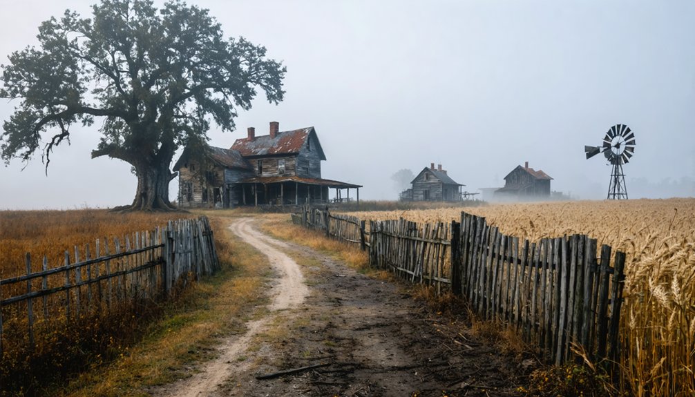
Center Point, Kansas: The Heartland’s Silent Testimony to Dust Bowl Migration
When driving through the windswept plains of western Kansas today, you’ll find little evidence that Center Point once thrived as a bustling agricultural community.
This ghost town stands as a silent witness to the devastating Dust Bowl era that transformed the heartland’s landscape and forced mass exodus westward.
Center Point’s agricultural resilience collapsed under the weight of environmental catastrophe, leading to inevitable community decline.
The town’s story unfolds in these stark phases:
- Fertile farmland turned to barren dust fields from prolonged drought
- Massive topsoil loss rendered wheat farming untenable
- Water sources dried up, crippling local grain mills
- Families abandoned homes, joining the great migration to California
What remains are scattered foundations and memories – testimonies to the freedom sought by those who once cultivated this unforgiving land.
Dearfield, Colorado: The Lost African-American Agricultural Colony
Among the forgotten agricultural settlements dotting America’s western landscape, Dearfield stands as a remarkable tribute to African American resilience and ambition in the early 20th century.
Founded in 1910 by Oliver Toussaint Jackson, this colony embodied the pursuit of Agricultural Independence for Black Americans just 25 miles east of Greeley.
Beyond mere settlement, Jackson’s vision birthed a sanctuary where Black Americans could harvest both crops and dignity.
You’ll find only decaying remnants today where once 700 residents transformed challenging terrain into productive farmland growing everything from corn to watermelons.
The Dearfield Legacy represents one of America’s most significant Black homesteading communities, flourishing during WWI before succumbing to the Dust Bowl’s devastation.
Despite mastering dry farming techniques and establishing churches, schools, and businesses, settlers couldn’t overcome the lack of irrigation rights to the nearby South Platte River—a poignant indication of freedom sought but ultimately constrained.
Hildebran, North Dakota: Where Wheat Fields Reclaimed Main Street
Nestled within the vast prairie expanse of western North Dakota, Hildebran emerged in 1913 as a hopeful outpost along the Great Northern Railway‘s expanding line. This wheat economy-dependent town flourished briefly before environmental and economic forces conspired against it.
As you stand where Main Street once bustled, you’ll find only wheat fields now reclaiming the land.
Hildebran’s decline occurred through a perfect storm of challenges:
- The Great Depression collapsed wheat prices, bankrupting local farmers
- Dust Bowl conditions devastated crops and livelihoods
- Railway service diminished, severing crucial market connections
- Mechanization reduced need for agricultural labor
Today, this quintessential ghost town exists only in foundations and memories, its abandoned ambitions returning to the soil from which they grew—a poignant reminder of rural communities that couldn’t withstand agriculture’s boom-and-bust cycles.
Frequently Asked Questions
Why Don’t Agricultural Ghost Towns Attract as Many Tourists as Mining Towns?
You’ll find agricultural ghost towns lack the dramatic wealth narratives and visible remnants that give mining towns their tourist appeal and historical significance. Their slower decline simply isn’t as enthralling to freedom-seeking explorers.
Can You Legally Explore Abandoned Farm Buildings in Ghost Towns?
Generally no. You’ll face legal implications entering these privately owned spaces without permission. Navigate the historical landscape with caution—safety concerns and property rights intersect where these forgotten structures stand.
How Do Researchers Document the Histories of Forgotten Agricultural Communities?
Like diggers unearthing buried treasures, you’ll find researchers piecing together these lost places through historical records, oral histories, archaeological surveys, census data, and field mapping that reveals their spatial footprints.
Among the many fascinating discoveries are the deserted settlements of the Civil War, which tell stories of resilience and loss. Each location serves as a poignant reminder of the lives once lived there and the struggles faced by the communities during turbulent times. As researchers delve deeper, they illuminate the connections between these sites and their historical significance, enriching our understanding of American history.
What Happened to the Farmland Surrounding These Ghost Towns?
You’ll find abandoned fields where poor farming practices led to soil degradation, while other lands were absorbed into industrial agriculture operations or simply returned to nature, reshaping America’s rural landscape forever.
Are There Efforts to Repopulate Any Abandoned Agricultural Communities?
Like seeds sprouting through cracked concrete, you’ll find community revitalization efforts emerging across America’s abandoned farmlands. Immigration programs, local food infrastructure investments, and sustainable agriculture initiatives are reclaiming these once-empty landscapes, breathing freedom back into forgotten rural spaces.
References
- https://www.visittheusa.com/experience/5-us-ghost-towns-you-must-see
- https://en.wikipedia.org/wiki/Wikipedia:WikiProject_Ghost_towns
- https://www.geotab.com/ghost-towns/
- https://www.wikiwand.com/en/articles/ghost_town
- https://en.wikipedia.org/wiki/List_of_ghost_towns_in_Colorado
- https://whakestudios.com/us-ghost-towns/
- https://en.wikipedia.org/wiki/Ghost_town
- https://devblog.batchgeo.com/ghost-towns/
- https://www.youtube.com/watch?v=AcPIBM_FrP4
- https://www.legendsofamerica.com/gt-emergingghosttowns/