Arkansas contains approximately 20 officially recognized ghost towns according to state tourism records, though you’ll find broader historical inventories documenting over 300 abandoned settlements across the state’s 75 counties. This discrepancy stems from varying definitions—whether you’re counting sites with standing structures versus communities that have vanished entirely. Notable examples include Rush, a zinc mining hub near Buffalo River, and Monte Ne, now submerged beneath Beaver Lake. The distribution spans counties like Washington, Marion, and Union, each preserving distinct frontier heritage that reveals how transportation networks, mining booms, and economic shifts shaped Arkansas’s vanished communities.
Key Takeaways
- Arkansas officially recognizes approximately 20 ghost towns, ranking 48th nationally in official counts.
- Broader inventories list over 300 abandoned places across the state, depending on definition criteria used.
- Discrepancies between sources range from 20 to hundreds due to varying definitions of ghost towns versus urban decay.
- Notable ghost towns include Rush, a zinc mining hub, and Monte Ne, now submerged beneath Beaver Lake.
- Ghost towns are distributed across Washington, Marion, Union, Carroll, and Buffalo River area counties.
Estimating the Total Number of Ghost Towns in Arkansas
How many ghost towns actually dot the Arkansas landscape? You’ll find conflicting data depending on your source. National rankings place Arkansas 48th with just 20 ghost towns.
Conflicting sources list Arkansas anywhere from 20 officially recognized ghost towns to hundreds of abandoned settlements across the state.
Yet historians estimate up to 50,000 exist nationwide, suggesting Arkansas holds far more.
Geotab’s mapping project confirms over 3,800 US sites with standing structures, though Arkansas remains underrepresented in this dataset.
Rootsweb compilations document dozens of Arkansas locations—from Austin to Yochum—while broader inventories list over 300 abandoned places statewide.
The discrepancy stems from definitional differences: strict ghost town criteria versus urban decay classifications.
Historical preservation efforts focus on sites with remaining buildings, excluding countless vanished communities. Many of these communities were established between late 1700s and early 1800s, linked to steamboat trade and railroad access before declining. Notable among Arkansas’s documented ghost towns is Rush, a zinc mining settlement that operated from the 1880s through the 1960s and is now protected as part of Buffalo National River.
You’re likely looking at 20 to 50 documented ghost towns, with hundreds more forgotten settlements awaiting rediscovery.
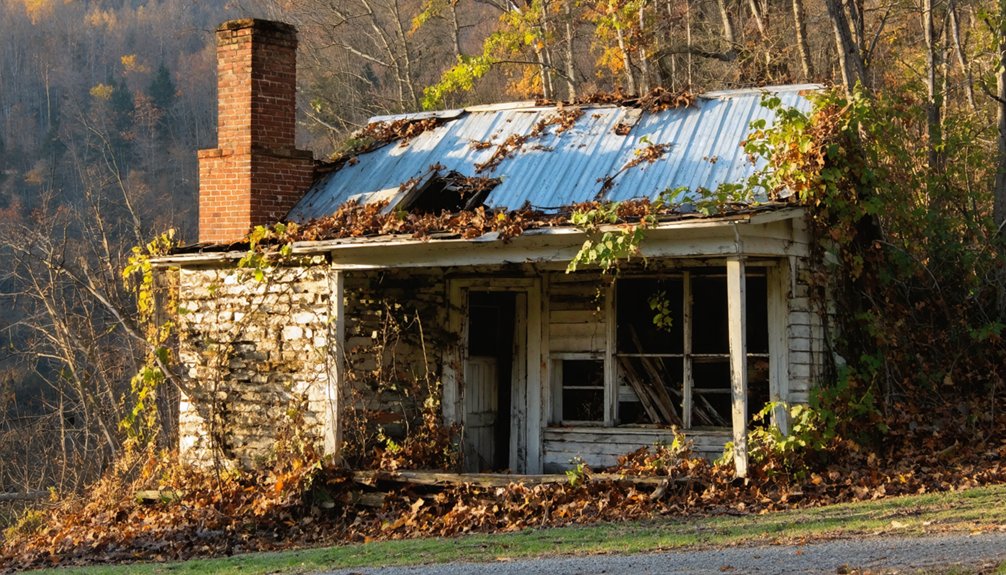
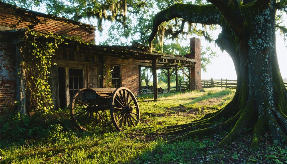
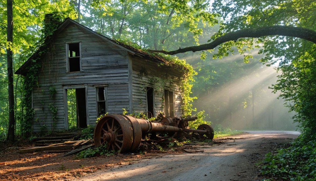
Rush: Arkansas’s Most Famous and Accessible Ghost Town
When prospectors arrived along Rush Creek in the early 1880s searching for lost silver mines from Indian legends, they discovered shiny metallic flakes that would transform the remote Arkansas wilderness into the state’s zinc capital.
What began as a wild west mining camp of tents and rock shelters evolved into Arkansas’s most prosperous city per capita by 1916, with nearly 5,000 residents during World War I.
The dramatic arc of Rush’s existence reflects mining frontier reality:
- Ten mining companies operated 13 developed mines at peak production
- Post-war zinc price collapse triggered irreversible population decline
- The last Morning Star Mine closed in 1931, sealing the town’s fate
- By 1972, Rush earned official ghost town designation within Buffalo National River lands
A large zinc nugget weighing 13,000 pounds from the Morning Star mine received awards at the 1892 Chicago World Fair, cementing Rush’s international reputation.
The 1300-acre historic district preserves remnants of log cabins, rock wall foundations, mines, and community structures from the boom town era.
Today, you’ll find Arkansas’s only ghost town between the Mississippi River and Rocky Mountains.
Submerged History: Monte Ne and Other Water-Lost Communities
You’ll find Arkansas’s most unusual ghost town beneath Beaver Lake’s surface, where William Hope “Coin” Harvey’s Monte Ne resort—established in 1901 with imported Italian gondolas and ambitious infrastructure exceeding $400,000—met its fate during the lake’s 1965 construction.
The U.S. Army Corps of Engineers’ survey error led to the dismantling of Harvey’s once-thriving planned community that operated until bankruptcy in the mid-1930s.
During drought conditions and low water levels, the submerged amphitheater foundations and hotel remnants emerge as Arkansas’s “Atlantis,” revealing the physical legacy of a 30-year resort venture that ended when its founder died penniless in 1936.
The site featured Arkansas’s first indoor swimming pool along with Missouri Row and Oklahoma Row hotel structures.
The site has attracted modern explorers and documentarians investigating the abandoned resort’s atmosphere, with some seeking evidence of residual presence among the ruins of this failed Ozark Mountain community.
Monte Ne’s Visionary Origins
Known as “Coin” Harvey, William Hope Harvey purchased 320 acres around Silver Springs in 1900 and transformed the area into Monte Ne—a name meaning “mountain water”—with remarkably ambitious plans for a resort town. After forming the Monte Ne Investment Company in December 1900, Harvey channeled $100,000 into his visionary planned community, which opened May 4, 1901.
His audacious vision included:
- World’s largest log hotels featuring 300-foot wings and dedicated five-mile rail line
- Progressive social freedoms like mixed-gender swimming and unconventional golf attire
- Complete self-sufficiency through private post office, bank, newspaper, and power company
- Archaeological discoveries preserved today through artistic interpretations at Rogers Historical Museum
Harvey’s ambitious experiment represented freedom from conventional resort development, establishing Arkansas’s first golf course and indoor swimming pool. Guests arrived via Venetian gondola at a transfer station connected to the five-mile rail line from Lowell, crossing a lagoon that separated the station from the hotels. The resort featured an elaborate bathhouse with an indoor pool with slides and heated water, showcasing Harvey’s commitment to modern luxury amenities.
Beaver Lake’s Drowning Impact
By June 1966, the U.S. Army Corps of Engineers completed Beaver Lake’s construction, permanently submerging Monte Ne’s resort community beneath water. You’ll find that almost all original structures disappeared underwater, creating what observers describe as “an Atlantis of Arkansas.”
The amphitheater and bridge structures emerge only during severe droughts—first reappearing on January 22, 1977, when water levels dropped 27 feet below average. In 2006, receding waters exposed the amphitheater’s upper portion again.
Oklahoma Row’s foundation and Missouri Row’s fireplace remnants constitute the primary surviving structures. The visible tower on Oklahoma Row once stood as part of the resort area. The Corps demolished the remaining hotel tower in February 2023 due to vandalism.
These ghostly legends and haunted landscapes attract visitors seeking Arkansas’s submerged history, though most artifacts remain permanently inaccessible beneath the reservoir’s depths. The Rogers Historical Museum preserves Harvey’s legacy through relics including a cement chair, a wooden pyramid model, and his death mask.
Visible Ruins During Droughts
During periods of severe drought, Monte Ne transforms from a fully submerged archaeological site into a partially visible ghost town, with the amphitheater serving as the most prominent and well-preserved ruin to emerge from Beaver Lake’s depths. Water level fluctuations reveal remarkable underwater archaeology that government control typically keeps hidden beneath the surface.
What drought conditions expose:
- 2006’s revelation: Waters receded to their lowest levels since 1984, exposing amphitheater walls that hadn’t seen sunlight in decades.
- Foundation remnants: Oklahoma Row’s basement and Missouri Row’s four-sided concrete fireplace emerge along the shoreline.
- Harvey’s unfinished vision: The retaining wall for his never-constructed pyramid becomes accessible.
- Fishing opportunities: 2005’s low water levels allowed anglers direct access to the amphitheater area.
These cyclical revelations offer you glimpses into deliberately submerged American history.
Mining Boom and Bust: Zinc Industry Ghost Towns
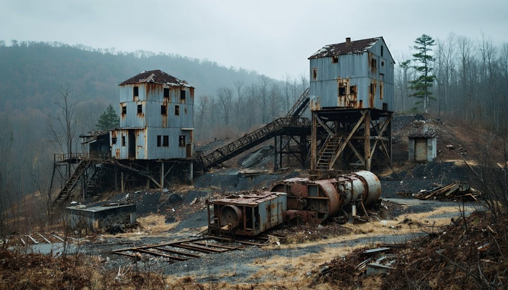
You’ll find Arkansas’s most significant mining ghost towns emerged from the zinc industry‘s dramatic rise and fall during the early twentieth century. Rush, located near the Buffalo River, transformed from a prospecting camp in the 1880s into Arkansas’s zinc capital during World War I.
During this period, prices surged from $14 to $160 per ton, and the population swelled to an estimated 6,000 residents. The post-war market collapse triggered rapid abandonment, leaving Rush and similar communities like Zinc in Boone County as preserved archaeological sites that document the transient nature of extractive industry settlements.
Rush’s Mining Legacy
The discovery of zinc ore along Rush Creek in 1880 transformed a quiet Arkansas hollow into one of the state’s most significant mining districts. John Wolfer’s initial find, though mistaken for silver, sparked four distinct boom periods that would establish Rush as the state’s premier zinc mining center.
The Morning Star Mine alone produced four tons daily by 1898, generating profits of $500-$1,000.
Rush’s enduring achievements include:
- A 12,750-pound smithsonite nugget winning the blue ribbon at Chicago’s 1893 World’s Fair
- Peak wartime production employing thousands at wages of 19-35 cents per hour
- Fourteen operational mines supporting a population of 5,000 residents
- National recognition for zinc mining excellence in ghost town preservation efforts
The district’s economic influence shaped North Arkansas development until final closure in 1931.
Post-War Economic Collapse
When World War I ended in 1918, Rush’s zinc industry confronted an immediate economic crisis as wartime demand evaporated and global prices plummeted. Excess global supply forced multiple mines to close, triggering rapid urban decay as the population crashed from thousands to just 344 by 1920.
You’ll find that subsequent revival attempts in the 1920s failed against cheap imported zinc, while a 1958 mill project near Buffalo River likewise couldn’t compete. The Morning Star Mine, Arkansas’s largest zinc producer, shuttered permanently in 1931.
Processing facilities were dismantled for salvage, and the post office closed mid-1950s. Today, Rush’s transformation into a ghost town enables historical preservation through the Buffalo National River system, maintaining this zinc-era landscape for public interpretation.
Regional Distribution and County Concentrations
- Washington County’s frontier heritage beckons through Pettigrew’s 1,400-resident peak and multiple unincorporated communities along Route 16.
- Marion County’s architectural remnants at Rush and Yochum provide tangible tourism opportunities for independent exploration.
- Union County’s dual sites at Blanchard Springs and Champagnolle Landing preserve Southern Arkansas’s commercial river history.
- Carroll County’s dual listings demonstrate northwestern settlement density during territorial expansion.
Exploring Arkansas’s Lesser-Known Abandoned Settlements
Along the Buffalo River’s limestone bluffs, Rush Ghost Town stands as Arkansas’s most accessible abandoned settlement, where zinc mining operations once employed hundreds during World War I’s metal demands.
Rush Ghost Town preserves World War I-era zinc mining history along Buffalo River’s bluffs as Arkansas’s most accessible abandoned settlement.
You’ll find free access to preserved structures within Buffalo National River boundaries, making preservation efforts tangible for exploration.
Marion County harbors multiple forgotten communities: Eros retains its schoolhouse and general store ruins, while Bruno’s 1800s cemetery documents pioneer settlements.
Local legends surround Monte Ne’s submerged resort structures beneath Beaver Lake, though 2023 demolition removed final visible remnants.
River commerce casualties include Hopefield, consumed by Mississippi River waters, and Davidsonville, now preserved as Arkansas’s first territorial seat.
Timber industry ghosts like Graysonia and Okay reveal silent foundations where company towns once prospered before economic collapse ended operations.
Frequently Asked Questions
Are There Any Legal Restrictions on Visiting Ghost Towns in Arkansas?
You’ll face legal restrictions based on property rights and trespassing laws. Public sites like Rush remain accessible, but private locations such as Dogpatch USA prohibit entry. Always verify ownership before exploring to avoid violations and preserve your freedom.
What Safety Precautions Should Visitors Take When Exploring Abandoned Structures?
Before you enter crumbling doorways, prioritize urban exploration protocols: you’ll need proper safety gear including sturdy boots, helmets, flashlights, and long protective clothing. Always use the buddy system, carry first-aid supplies, and respect all posted trespassing warnings.
Can Artifacts or Items Be Collected From Arkansas Ghost Town Sites?
No, you can’t collect artifacts from Arkansas ghost towns. Federal and state historical preservation laws strictly prohibit artifact collection on public lands, including National Park Service sites and protected archaeological areas, with penalties enforced statewide.
Which Ghost Towns Offer Guided Tours or Visitor Centers?
You’ll find visitor centers at Davidsonville State Park with replica flatboat displays and Rush’s federally-managed interpretive trails. These sites exemplify historic preservation excellence while creating tourism opportunities through self-guided experiences that let you explore Arkansas’s abandoned settlements independently.
How Do Property Ownership Laws Affect Access to Ghost Town Locations?
Property rights dictate you’ll face trespassing violations when entering privately-owned ghost towns without permission, while access regulations permit free exploration of federally-managed sites like Rush, where public land status overrides private claims through historic preservation designations.
References
- https://arkansasfrontier.com/ghost-towns-in-arkansas/303766/
- https://www.axios.com/local/nw-arkansas/2024/01/02/arkansas-ghost-towns-mapped
- http://freepages.rootsweb.com/~gtusa/history/usa/ar.htm
- https://everafterinthewoods.com/forgotten-ghost-towns-in-arkansas-that-are-eerially-scenic/
- https://www.youtube.com/watch?v=sJ1V8Yjr04w
- https://www.geotab.com/ghost-towns/
- https://www.uaex.uada.edu/environment-nature/musings-on-nature-blog/posts/ghost-towns.aspx
- https://en.wikipedia.org/wiki/List_of_ghost_towns_in_Arkansas
- https://www.tripadvisor.com/Attractions-g28925-Activities-c47-t14-Arkansas.html
- https://www.loveexploring.com/gallerylist/188219/the-us-state-with-the-most-ghost-towns-revealed