You’ll find approximately 21 to 30 documented ghost towns across Kentucky, though the exact count remains uncertain due to inconsistent classification criteria—some sources include settlements with dwindling populations while others only recognize fully abandoned sites. This variability stems from fragmented documentation, the absence of a centralized state database, and legal ambiguities surrounding town dissolution. Coal industry collapse, resource depletion, and infrastructure shifts drove most abandonments, with notable examples including Paradise, Blue Heron, and Barthell. The article ahead explores their histories, preservation efforts, and planning guidance for exploration.
Key Takeaways
- Kentucky has approximately 21 to 30 ghost towns, with exact counts varying due to inconsistent classification criteria and fragmented documentation.
- Wikipedia lists about 21 documented sites but acknowledges its inventory is incomplete, reflecting ongoing challenges in comprehensive state-wide documentation.
- Different sources use varying standards—some count settlements with dwindling populations, while others only include fully abandoned sites.
- No centralized state database exists, forcing reliance on scattered records, publications like Speck’s guide, and anecdotal reports.
- Classification challenges stem from legal ambiguities and methodological differences in defining what constitutes a ghost town versus active settlement.
Estimating the Total Number of Ghost Towns in Kentucky
Determining the precise number of ghost towns in Kentucky presents significant methodological challenges due to incomplete documentation and inconsistent classification standards.
You’ll find approximately 21-30 documented locations across various sources, though Wikipedia explicitly acknowledges its list remains incomplete.
The absence of detailed state databases means you’re relying on fragmented historical records and local knowledge rather than systematic cataloging.
Legal classifications further complicate enumeration—Kentucky’s 2022 dissolution of five defunct municipalities, including Poplar Hills, demonstrates how administrative “ghost cities” differ from abandoned settlements.
Urban development patterns and population migration in Appalachia created conditions for gradual depopulation, yet standardized definitions determining what qualifies as a ghost town remain elusive.
Ghost towns often mark past economic activity, particularly from Kentucky’s mining and trade industries that once sustained thriving communities before eventual abandonment.
Many settlements originated as coal mining towns that provided numerous jobs for locals before declining as the industry faded.
Consequently, you can’t establish definitive totals without accepting significant methodological limitations inherent in available documentation systems.
Different Sources Report Varying Counts
The variance in reported ghost town totals reflects the fragmented nature of Kentucky’s historical documentation systems. You’ll find Wikipedia cataloging 21 sites, WBKR identifying 20 locations, and YouTube highlighting 11 towns, while Rootsweb estimates Kentucky contains a fraction of America’s 50,000 ghost towns.
These discrepancies stem from inconsistent classification criteria—some sources count only completely abandoned settlements, others include sites with minimal populations like Yocum’s 20 residents in 1990. Ghost town preservation efforts remain hindered by this documentation chaos, as researchers can’t agree on basic definitions.
The 2022 law targeting “ghost cities” like Poplar Hills demonstrates Kentucky’s struggle with abandoned town populations existing in legal limbo. The Department for Local Government identified five cities for dissolution, including Blandville, Monterrey, South Park View, and Vicco alongside Poplar Hills. You’re witnessing archival records that prioritize different historical markers—mining operations, railroad stations, or municipal dissolution—creating parallel but incompatible inventories. Publications by Gary B. Speck, including The Ghost Town Research Guide backed by over 30 years of research, attempt to provide comprehensive documentation for both casual visitors and researchers.
The Coal Mining Legacy Behind Kentucky’s Abandoned Towns
Coal company dominance fundamentally shaped Kentucky’s ghost town landscape, with corporate entities like Stearns Coal & Lumber Company constructing entire settlements as extractive infrastructure rather than permanent communities.
You’ll find these company towns were deliberately designed as transitory operations—buildings disassembled and moved by train when coal deposits depleted. The Stearns empire controlled Mine 18 and Blue Heron camp until 1962, while U.S. Coal & Coke founded Lynch in 1917, only to abandon it post-1940s.
This pattern of urban decay repeated across Kentucky as economic decline followed resource exhaustion. Mine 18 commenced in 1937, with the Kentucky & Tennessee Railroad transporting coal from the site until mining activity slowed in the 1950s.
Paradise exemplifies corporate control’s ultimate expression: Tennessee Valley Authority bought out 800 residents in 1967 due to ash fall health concerns, then demolished every structure for industrial expansion, erasing the town completely. The town’s name derives from the Latin paradisus, originally meaning a walled garden or enclosed space, an ironic designation for a settlement destroyed by industrial development.
Paradise: Kentucky’s Most Famous Ghost Town
You’ll find Paradise’s story immortalized in John Prine’s 1971 folk ballad “Paradise,” which documents how strip mining and the Tennessee Valley Authority’s fossil plant construction eliminated this Muhlenberg County community along the Green River.
The town’s coordinates (37°16′05″N 86°59′01″W) place it 10.5 miles east-northeast of Greenville, where it operated from its early 1800s founding as Stom’s Landing until its official disincorporation on December 30, 1967. The Paradise Fossil Plants caused environmental controversy through their rain of ash and debris that negatively impacted residents’ respiratory health.
While Prine’s lyrics suggest the Green River “drowned” Paradise, historical records indicate the TVA’s buyout and subsequent demolition—not reservoir submersion—caused the town’s physical erasure, leaving only a cemetery atop a hill near the power plant site. About 1 mile north of Paradise stood Airdrie Hill, an iron furnace built by Scottish immigrants in 1854 that operated for only 8 weeks before boiler failures ended the venture.
John Prine’s Musical Tribute
Few American ghost towns have achieved the cultural immortality that Paradise, Kentucky, earned through John Prine’s 1971 debut single. His song “Paradise” documented Peabody Coal Company’s systematic destruction of Muhlenberg County through strip mining, with lyrics describing how “Mr. Peabody’s coal train” removed the town “track by track.”
You’ll find Prine’s narrative captured the environmental devastation beginning in 1959, when Paradise Fossil Plant construction and mining operations commenced. The song became an anthem highlighting urban decay versus historical preservation, documenting how ash fallout forced residents from their homes and destroyed gardens.
Located 10 miles northeast of Greenville on the Green River in eastern Muhlenberg County, Paradise had operated a post office since 1852. The Tennessee Valley Authority purchased and demolished the remaining structures in 1967, officially closing Paradise with only a hilltop cemetery marking where the town once stood.
Muhlenberg County Location Details
Paradise’s geographical position in Muhlenberg County placed it 10.5 miles east-northeast of Greenville along the Green River. Leonard Stom established a ferry service in the early 1800s that gave the settlement its original name, Stom’s Landing.
The town’s transformation through multiple designations reflected westward expansion patterns before receiving its post office designation as Paradise in 1852.
The settlement’s location proved both advantageous and ultimately catastrophic:
- Coal deposits attracted Pittsburg & Midway and Peabody companies, driving economic growth
- TVA’s Paradise Fossil Plant construction precipitated total urban decay by 1967
- Cemetery preservation represents minimal cultural preservation efforts in the abandoned townsite
You’ll find the cemetery atop a hill overlooking the former street grid, where crumbled memorials and deteriorated concrete mark Kentucky’s most documented ghost town narrative.
Green River Reservoir Submersion
The Tennessee Valley Authority’s systematic acquisition and demolition of Paradise constitutes one of Kentucky’s most thoroughly documented cases of industrial displacement.
Though the town’s destruction resulted from coal plant construction rather than reservoir creation, it stands out for its methodical approach. Unlike typical ghost towns submerged beneath hydroelectric projects, Paradise vanished through deliberate buyout and demolition in 1967.
You’ll find no flooded relics beneath Green River’s waters here—TVA razed all structures after purchasing residents’ properties for what survivors described as minuscule compensation. The approximately 800 final inhabitants departed by December 30, 1967.
Their homes were demolished to accommodate the Paradise Fossil Plant. Only a small cemetery atop a hill survives, marking where a community once thrived along the Green River tributary before corporate interests literally hauled Paradise away.
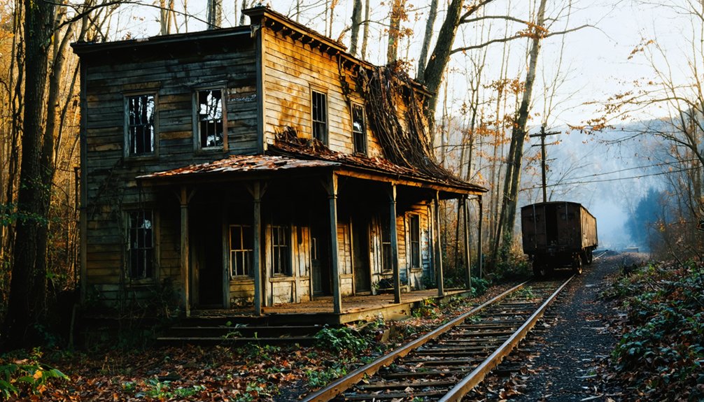
Notable Ghost Towns Worth Exploring
Kentucky’s landscape harbors several ghost towns that offer tangible connections to the state’s industrial and agricultural past, each presenting distinct historical narratives and varying degrees of physical preservation.
Kentucky’s abandoned settlements stand as unvarnished monuments to vanished economies, their weathered remnants documenting industrial collapse and demographic exodus.
Prime exploration sites include:
- Paradise (Muhlenberg County): Immortalized in John Prine’s song, this coal mining community experienced complete erasure following TVA acquisition. Only the hilltop cemetery survives, overlooking vanished streetscapes—a stark example of urban decay.
- Barthell (McCreary County): Established 1902 by Stearns Coal, this camp maintains intact structures despite preservation challenges, offering rare architectural documentation of mining operations.
- Creelsboro (Russell County): This Cumberland River settlement declined post-dam construction. Remaining buildings and Rockhouse Arch natural formation provide accessible historical investigation.
Each site presents unrestricted access to Kentucky’s industrial heritage, permitting independent historical research without bureaucratic constraints.
Blue Heron Mining Camp and Historic Preservation
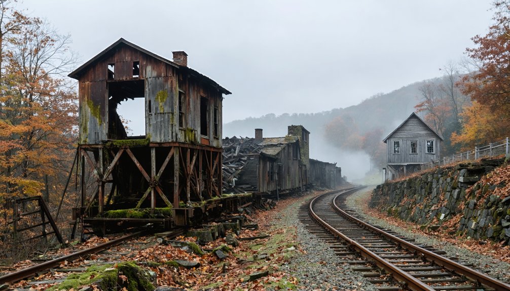
Since 1989, Blue Heron Mining Camp has represented a paradigmatic shift in ghost town preservation methodology, transforming the abandoned Mine 18 site into an interpretive center that prioritizes educational access over structural reconstruction. You’ll find open metal “ghost structures” replacing original buildings that decayed after Mine 18’s 1962 closure.
The National Park Service’s approach addresses preservation challenges inherent to company towns: transitory construction lacking permanent foundations made authentic restoration impossible by the 1980s. Instead, photographic exhibits and oral histories document mining techniques—coal sorting into nut, block, and egg sizes at the tipple, gondola car loading via chutes—while original locomotives and coal cars provide tangible connections.
This methodology allows you to experience historical narratives without artificial reconstruction, maintaining archival integrity while ensuring unrestricted public engagement with Kentucky’s industrial heritage.
Why Kentucky Towns Became Abandoned
When Kentucky’s coal industry entered terminal decline during the mid-twentieth century, extractive economies that had sustained entire communities for generations collapsed with catastrophic demographic consequences. You’ll find urban decay patterns across Barthell, Bells Mines, and Bon Jellico—company towns abandoned when residents couldn’t maintain payments on homes tied to defunct mining operations.
Multiple mechanisms drove abandonment:
- Industrial exhaustion: Harlan, Lynch, and Stearns camps emptied as coal seams depleted and profitability vanished.
- Infrastructural displacement: Paradise’s farming community faced forced relocation when Tennessee Valley Authority’s coal-fired plant created uninhabitable air quality conditions.
- Transportation obsolescence: Creelsboro, Fords Ferry, and Mill Springs declined irreversibly after steamboat commerce ended and highway development bypassed river-dependent settlements.
Historical preservation efforts now document these sites, though structures were systematically demolished, leaving archaeological remnants and cemetery markers as primary evidence.
Ghost Towns Near Covington and Northern Kentucky

Unlike central and eastern Kentucky’s extractive industry ghost towns, northern Kentucky’s settlement patterns near Covington produced no confirmed fully abandoned communities meeting traditional ghost town criteria.
You’ll find instead sites of urban decay within Covington’s historic districts—the John Brenner Brewing Company’s flooded tunnels at 621-625 Scott Street exemplify infrastructure collapse rather than complete abandonment.
Covington’s population decline during the 1960s-1970s left deteriorating structures, but continuous habitation persisted.
The Carneal House and Licking Riverside Historic District demonstrate how preservation efforts maintain architectural integrity while ghost lore attracts tourism.
You’re more likely to encounter haunted history tours commodifying supernatural narratives than authentic ghost towns.
Northern Kentucky’s abandonment manifests as selective building decay within functioning municipalities, not wholesale community evacuation characteristic of mining-dependent settlements elsewhere statewide.
Planning a Ghost Town Road Trip Through Kentucky
Planning a thorough ghost town road trip through Kentucky requires understanding that approximately 21 documented sites appear on Wikipedia’s incomplete list, while Rootsweb directories catalog dozens more across counties including Boyd, Hickman, Estill, and Madison—though no definitive statewide count exists due to inconsistent definitional criteria separating true abandonment from partial decay.
Effective routing balances urban decay documentation with historic preservation appreciation:
- Appalachian concentration: McCreary County’s Barthell and Blue Heron offer restored coal camps with intact steel structures
- Western circuit: Muhlenberg’s Paradise cemetery to Crittenden’s forested Bells Mines via wildlife management trails
- Extended loop: Louisville-based 500-mile haunted circuit covers 10 sites in 9.25 hours
Verify accessibility beforehand, particularly lake-level variations affecting submerged towns like Birmingham and seasonal trail conditions at remote furnace sites.
Frequently Asked Questions
Are Kentucky’s Ghost Towns Safe to Visit and Explore?
You’ll find Kentucky’s ghost towns generally safe for exploration, with preserved sites like Barthell and Blue Heron offering tourism opportunities through historical preservation. However, you should exercise caution at abandoned structures and remote locations with overgrowth or structural hazards.
Can You Buy Property in Kentucky Ghost Towns?
Unlike homesteading frontier territories, you’ll find property purchase regulations strictly govern Kentucky ghost towns. Historic preservation laws and current ownership status—whether private, corporate, or government-held—determine your acquisition possibilities. Research title records before pursuing purchases.
What’s the Oldest Ghost Town in Kentucky?
Paradise, established around 1797-1800, ranks among Kentucky’s oldest ghost towns. You’ll find its historical preservation limited to one cemetery, while the cleared land now serves as wildlife habitats near the former coal plant site.
Do Any Ghost Towns in Kentucky Have Paranormal Activity?
Kentucky’s ghost towns lack documented paranormal investigations or verified ghostly legends. You’ll find atmospheric settings at Blue Heron and Barthell that evoke eerie feelings, but archival sources reveal no substantiated supernatural activity—only compelling industrial ruins and preserved historical structures.
Which Kentucky Ghost Town Is Closest to Louisville?
Blandville in Ballard County stands closest to Louisville, approximately 30-40 miles west. You’ll find minimal historical preservation there, though it’s less developed as tourist attractions compared to Ghost Town on the River’s former Fontaine Ferry Park site within Louisville itself.
References
- https://en.wikipedia.org/wiki/List_of_ghost_towns_in_Kentucky
- https://wbkr.com/visit-these-20-creepy-kentucky-ghost-towns-for-a-halloween-road-trip/
- https://www.youtube.com/watch?v=D9gOmfCuKLs
- http://freepages.rootsweb.com/~gtusa/history/usa/ky.htm
- https://www.kentuckybb.com/Blog/Get-Haunted-and-Go-Ghost-Hunting-in-Kentucky.html
- https://www.geotab.com/ghost-towns/
- https://www.freakyfoottours.com/us/kentucky/
- https://www.lpm.org/news/2023-09-26/a-new-kentucky-law-is-dissolving-ghost-cities-including-one-in-jefferson-county
- https://www.auditor.ky.gov/Auditreports/Miscellaneous/2012GhostGvoernmentSpecialDistrictsreport.pdf
- https://www.youtube.com/watch?v=WGLC7I4uZpU